 Block
From the record
10 National Register listings published here.
Sources: the National Register database, National Park Service
19 topographic sheets cover 10 settlements here, and 10 properties are on the National Register of Historic Places.
10 National Register listings published here.
Sources: the National Register database, National Park Service
Every property in this county listed on the National Register of Historic Places, with the year it was listed and the federal nomination document.
| Photograph | Property | Type | Listed | Reference |
|---|---|---|---|---|
 | Downtown Salem Historic District | district | 2004 | 03001527 |
| First Presbyterian Church | building | 2013 | 13000917 | |
 | Henry Kuhle House | building | 2008 | 08000053 |
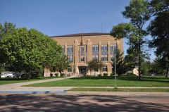 | McCook County Courthouse | building | 1993 | 92001862 |
| Ortman Hotel | building | 1997 | 97000144 | |
| Salem Rest Stop Tipi-Eastbound | object | 2015 | 14001181 | |
| Salem Rest Stop Tipi-Westbound | object | 2015 | 14001182 | |
| South Dakota Dept. of Transportation Bridge No. 44-212-090 | structure | 1993 | 93001302 | |
 | St. Mary's Catholic Church | building | 1985 | 85001354 |
| Stark Round Barn | building | 2001 | 01000637 |
Every wildfire the federal occurrence database records inside this county: 137 of them, burning about 1,803 acres. 2 started naturally and 1 was recorded as arson. Each settlement page carries the fires within five miles of it.
| Reported cause | Fires |
|---|---|
| Missing data/not specified/undetermined | 70 |
| Debris and open burning | 42 |
| Equipment and vehicle use | 13 |
| Railroad operations and maintenance | 3 |
| Misuse of fire by a minor | 2 |
| Natural | 2 |
| Other causes | 2 |
| Recreation and ceremony | 1 |
| Arson/incendiarism | 1 |
| Smoking | 1 |
The five largest, by the area the report gives. None of them was recorded as arson.
| Date | Cause | Size | Reported by | Name on the report |
|---|---|---|---|---|
| 7 May 2017 | Missing data/not specified/undetermined | 320 acres | South Dakota Wildland Fire Suppression | HOFER II |
| 13 April 2016 | Missing data/not specified/undetermined | 240 acres | South Dakota Wildland Fire Suppression | PAUL HOFER |
| 13 February 1999 | Debris and open burning | 140 acres | Spencer Volunteer Fire Department | DEL RAY DORALE |
| 16 October 2014 | Missing data/not specified/undetermined | 105 acres | South Dakota Wildland Fire Suppression | BACH |
| 24 October 1999 | Debris and open burning | 80 acres | Bridgewater Volunteer Fire Department | BRIDGEWATER 3 |
| 28 March 2017 | Missing data/not specified/undetermined | 80 acres | South Dakota Wildland Fire Suppression | WALDERA |
| 9 November 1999 | Debris and open burning | 60 acres | Bridgewater Volunteer Fire Department | BRIDGEWATER |
| 19 April 2020 | Railroad operations and maintenance | 60 acres | South Dakota Wildland Fire Suppression | CAREY |
Every settlement page carries the fires within five miles of it - see the settlement index below.
The NOAA Storm Events Database holds 391 reports for this county, causing 6 deaths, 156 injuries and about $35,871,750 in recorded property damage. Each settlement page carries the reports that name it.
| Kind of event | Reports |
|---|---|
| Hail | 189 |
| Thunderstorm Wind | 126 |
| Tornado | 40 |
| Flood | 18 |
| Flash Flood | 9 |
| Heavy Rain | 5 |
| Lightning | 2 |
| Funnel Cloud | 2 |
The most serious of them, by death, then injury, then recorded damage. The accounts are quoted exactly as the forecast office filed them.
| When | Event | Place named | Harm | What the report says |
|---|---|---|---|---|
| May 1998 | Tornado (F4) | Spencer | 6 killed, 150 hurt, $17,000,000 | The tornado from Hanson County destroyed most of Spencer as it strengthened and continued to grow. Most homes, other buildings, and other structures in Spencer were completely levelled. Debris and belongings were scattered over a large area, and one receipt blown from Spencer was found just west of Chandler, MN about 80 miles east of Spencer. The tornado killed 6 and injured 150 in Spencer. The tornado continued southeast from Spencer, widened, then weakened, and dissipated 4 miles southwest of Salem with another tornado then forming from the same storm. The tornado caused additional damage to trees, power lines, crops, and buildings on farms after moving southeast of Spencer. |
| June 2024 | Thunderstorm Wind | Salem | 2 hurt | Thunderstorm winds downed several trees in Salem and tipped over a semi-truck near town which resulted in minor direct injuries. |
| May 1991 | Thunderstorm Wind | not stated | 2 hurt | no account filed |
| July 1973 | Tornado (F2) | not stated | 1 hurt, $25,000 | no account filed |
| April 2005 | Thunderstorm Wind | Salem | 1 hurt, $10,000 | Thunderstorm winds blew over a truck on Interstate 90, causing minor injuries to the driver. |
| May 1993 | Tornado (F3) | Canistota to | $5,000,000 | A tornado caused extensive damage in the Canistota area. Four metal grain storage bins were severely damaged and the roof was blown off the grain elevator. A large roof was blown off a building in Canistota resulting in rain seeping through the floors of the building. The roof blew into another building causing damage, and the flying debris took out power lines and transformers. The storm nearly totaled a farm including the house, and destroyed barns on other farms. Buildings were damaged in Montrose and a farm and metal buildings were lost on a farm east of Montrose. |
| June 1992 | Tornado (F1) | not stated | $2,500,000 | no account filed |
| June 1992 | Tornado (F1) | not stated | $2,500,000 | no account filed |
| September 1995 | Hail | Salem | $2,000,000 | Widespread golf ball to baseball-size hail fell with some softball size hail reported. The hail broke windows and caused other damage to all homes and unprotected vehicles in Salem, including 150 cars at a dealership. Severe damage occurred to crops in the area. |
| June 2024 | Flood | Bridgewater | $1,720,000 | Rainfall amounts across McCook County from June 20-22 ranged from 5 to 8 inches. Widespread overland flooding ensued with additional flooding along the East Fork Vermillion River, West Fork Vermillion River, and Wolf Creek. ||Flood waters damaged 10 to 15 homes in Montrose, 8 to 10 homes in Salem, and 3 to 4 homes in Spencer. Numerous others reported water in their basements. Sewage backup also occurred in Montrose, Salem, and Spencer. Residential flood damages are estimated to be nearly 547 thousand dollars.||At the peak of flooding, U.S. Highway 81 was closed in more than four locations and South Dakota Highway 38 was closed at Montrose. Many other roads and culverts across the county were damaged or washed out. Preliminary damage assessments estimate loss to public infrastructure across the county to be nearly 1.17 million dollars.||The majority of overland flooding subsided by June 25, but river flooding continued through the end of the month. For additional information on river flooding, please see other flood entries for McCook County. |
| May 1998 | Tornado (F2) | Salem | $900,000 | no account filed |
| March 2019 | Flood | Bridgewater | $660,000 | Interstate 90 was closed due to water flowing over the road between exits 364 and 368 southeast of Salem. Other flooding resulted in extensive damage to public infrastructure including numerous county and township roads, culverts, and some bridges. |
| September 2019 | Flood | Bridgewater | $540,000 | Excessive rainfall from September 10-12 (8.27 inches in Bridgewater, 7.14 inches 6 miles northwest of Montrose, 6.08 inches in Montrose) caused extensive areal flooding. Hardest hit were areas near Montrose, where rising waters in the East Fork of the Vermillion River encroached on eastern portions of the city and prompted a mandatory evacuation of areas along First Avenue from Highway 38 to Main Street on September 12. Numerous county and township roads were washed out. Interstate 90 was closed from Humboldt to Bridgewater on September 12 and portions remained closed through September 16. State Highway 38 was closed from Montrose to Salem. Significant ponding of water also occurred in Spencer and Bridgewater. Lake Vermillion Recreational Area was closed due to flooding and remained closed through September 26 while damage was cleaned up. Property damage costs are rough estimates. Flooding also resulted in crop losses across the area. Crop loss estimates provided by the United States Department of Agriculture. |
| May 1993 | Tornado (F2) | northwest of | $500,000 | A tornado touched down on several farms destroying two pole barns, a grain bin, and a barn roof. |
| August 2004 | Thunderstorm Wind | Salem | $300,000 | Thunderstorm winds blew the press box off the grandstand at an athletic complex, damaged a crow's nest at the complex, and tore the roof off a mobile home. The winds also caused extensive tree damage with several trees blown down. The winds caused power line damage, resulting in a power outage. Crops in the area were damaged, especially corn, but the amount of damage was not known. Several vehicles were damaged by flying debris and windows on some buildings were broken. |
| April 2005 | Thunderstorm Wind | Canistota | $250,000 | Thunderstorm winds damaged numerous homes and other structures, as well as trees and power lines. Roofs were blown off a seed company building, a lumber yard building, and a large machine shed. Additional damage was done to these buildings and others. Shingles were blown off several roofs. The grandstand and one dugout at a ball park was destroyed, and the other dugout, the lights, and the outfield fence were damaged. Debris from the ball park was blown into a yard a block and a half away. Several vehicles were damaged, including windows blown out or knocked out by debris. |
| June 2014 | Flood | Unityville | $100,000 | Persistent moderate to heavy rain caused flooding of fields and other lowlands, including several roads, homes, and businesses. This flooding lasted for almost two days, and was aggravated locally by additional storms during that time. Some roads were damaged or washed out. |
| May 2011 | Thunderstorm Wind | Salem | $100,000 | Thunderstorm winds caused tree damage and blew down power lines in Salem, causing a power outage in Salem. The winds also caused heavy damage at two farmsteads east northeast of Salem. In addition to tree damage, at least four silos, three grain bins and four machine sheds were destroyed, and four augers, a grain cart, and a grain dryer were damaged. Two surviving trees stopped one destroyed grain bin from slamming into the house on one farmstead, while the house on another farmstead suffered minor damage from debris, including a piece of lumber from one machine shed blown into the roof. |
| September 2006 | Tornado (F2) | Bridgewater | $100,000 | A tornado affected 3 farmsteads, destroying numerous outbuildings, damaging farm equipment and a home, killing at least 5 cattle and injuring others. The tornado also damaged a hog confinement building and overturned a semi trailer on Interstate 90. |
| August 2004 | Thunderstorm Wind | Spencer | $100,000 | Thunderstorm winds destroyed a grain bin, damaged other small farm buildings, and blew down signs. The winds also blew down power lines, causing power outages. The winds caused widespread tree damage, including several trees blown down. Vehicles were damaged by tree debris. The winds also caused crop damage, but the amount of crop damage could not be determined. |
| June 2003 | Thunderstorm Wind | Salem | $100,000 | Thunderstorm winds caused tree damage, and blew down two walls of a concrete business. |
| July 2002 | Thunderstorm Wind | Salem | $100,000 | Thunderstorm winds caused widespread tree and power line damage. Many trees were blown down, and power lines were down throughout the city with resulting power outages. Minor damage to structures, such as shingles blown off, was also reported. |
| July 2000 | Thunderstorm Wind | Canistota | $100,000 | Thunderstorm winds destroyed several farm buildings, moved a large barn from its foundation, broke windows, and tore off siding from a house. The winds also caused tree damage, including large trees uprooted. |
| July 2000 | Thunderstorm Wind | Salem | $100,000 | Thunderstorm winds damaged a house and garage. |
| June 1999 | Hail | Canistota | $100,000 | Large hail broke many windows and dented vehicles. The hail also caused crop damage, but the amount of damage was not determined. |
| May 1998 | Tornado (F1) | Canistota | $100,000 | no account filed |
| August 2004 | Thunderstorm Wind | Montrose | $60,000 | Thunderstorm winds extensively damaged a house under construction. The garage was blown apart, and siding and shingles were blown away. The winds also blew down nearby electrical transmission structures and power lines, resulting in power outages. Crops were damaged in the area, with corn crops flattened or leaning. |
| July 2022 | Thunderstorm Wind | Salem | $50,000 | Thunderstorm winds caused significant damage to the Armory roof in Salem. |
| May 2011 | Thunderstorm Wind | Bridgewater | $50,000 | Thunderstorm winds, including a gustnado, caused damage to trrees and power lines, damaged grain bins and farm buildings, destroyed a pig barn, and damaged farm equipment. |
| July 2010 | Flood | Salem | $50,000 | Heavy rain caused major flooding of the east and West Fork Vermillion Rivers, and the Little Vermillion River. Fields, lowlands, roads, and parks were flooded. the most extensive flooding in the county was reported in and near Montrose, where roads, basements, ball parks, a campground, and other low areas were flooded. Flooding threatened a sewer lift station in Montrose, but it was kept operational. |
| May 2007 | Tornado (EF2) | Spencer | $50,000 | A tornado damaged a house on the west side of Spencer and caused tree damage before crossing into western Hanson County. |
| July 2002 | Thunderstorm Wind | Bridgewater | $50,000 | Thunderstorm winds caused widespread tree damage, and also blew down power lines. |
| June 2001 | Thunderstorm Wind | Salem | $50,000 | Thunderstorm winds caused damage at several farms, including a barn blown down, farm equipment damaged, and widespread tree damage. |
| June 1999 | Thunderstorm Wind | Canistota | $50,000 | Thunderstorm winds blew a fertilizer wagon into a car, blew over a propane tank, and caused tree damage. |
| June 1994 | Hail | Emery/Bridgewater/ | $50,000 | A three to five mile wide swath of hail caused widespread crop damage, as well as many broken windows and vehicle damage. Strong winds tore roofs off of several sheds, blew down a wall and signs in Bridgewater, and broke tree limbs. |
| June 1999 | Thunderstorm Wind | Spencer | $50,000 | no account filed |
| May 2016 | Lightning | Salem | $45,000 | Lightning killed 21 cattle that were gathered at a metal feeder. |
| July 2006 | Thunderstorm Wind | Canistota | $30,000 | Thunderstorm winds rolled and destroyed a camper. |
| August 2020 | Thunderstorm Wind | Canistota | $25,000 | Lids were ripped off grain bins, with large tree branches down. Property damage costs are rough estimates. |
| September 2019 | Flood | Canistota | $25,000 | After excessive two-day rainfall in the headwaters of the Vermillion River (6.78 inches 2 miles east of Montrose, 5.63 inches at Montrose), the East Fork of the Vermillion River near Parker (gage site VRPS2) reached the highest crest on record of 5.09 feet above flood stage on September 13. Numerous county roads and bridges from the gaging site upstream were inundated. |
| July 2011 | Hail | Canistota | $25,000 | Large hail stripped leaves off trees, dented vehicles, and caused an unknown amount of crop damage. |
| June 1984 | Tornado (F0) | not stated | $25,000 | no account filed |
| June 1979 | Tornado (F1) | not stated | $25,000 | no account filed |
| April 1973 | Tornado (F1) | not stated | $25,000 | no account filed |
| October 1971 | Tornado (F2) | not stated | $25,000 | no account filed |
| May 1965 | Tornado (F1) | not stated | $25,000 | no account filed |
| May 1965 | Tornado (F1) | not stated | $25,000 | no account filed |
| May 1965 | Tornado (F1) | not stated | $25,000 | no account filed |
| May 1954 | Tornado (F2) | not stated | $25,000 | no account filed |
| August 2004 | Thunderstorm Wind | Spencer | $20,000 | Thunderstorm winds blew over two semi trucks and a camper on Interstate 90. The winds also caused crop damage in the area. |
| July 2019 | Thunderstorm Wind | Canistota | $10,000 | Metal roof panels were ripped off a small apartment building. |
| September 2019 | Flash Flood | Canistota | $10,000 | Water up to 2 feet in depth flooded many roads in Canistota. |
| May 2012 | Thunderstorm Wind | Salem | $10,000 | Thunderstorm winds overturned a semi truck. |
| July 2010 | Thunderstorm Wind | Spencer | $10,000 | Thunderstorm winds blew over billboards and caused tree damage. |
| August 2004 | Thunderstorm Wind | Montrose | $10,000 | Thunderstorm winds caused tree and power line damage, with a resulting power outage. |
| June 1999 | Hail | Salem | $10,000 | Large hail broke windows in farm buildings and dented vehicles. |
| August 1998 | Lightning | Bridgewater | $10,000 | no account filed |
| June 1999 | Thunderstorm Wind | Salem | $5,000 | Thunderstorm winds blew the roof off a farm structure. |
| October 1997 | Thunderstorm Wind | Salem | $3,000 | no account filed |
| May 1965 | Tornado (F3) | not stated | $2,500 | no account filed |
The Survey's mineral resources record lists 5 workings inside this county. All of them still produce. Each settlement page carries the workings within five miles of it.
| Commodity | Workings |
|---|---|
| Sand and Gravel, Construction | 5 |
The least common of them first, because a county's hundredth gravel pit says nothing its first ten did not.
| Where | Site | Commodity | Status | Recorded |
|---|---|---|---|---|
| Brown Gravel Pit | Sand and Gravel, Construction | Producer | ||
| Dexter Mobige Pit | Sand and Gravel, Construction | Producer | ||
| Fendrich Sand & Gravel Pit | Sand and Gravel, Construction | Producer | ||
| Schaffer Pit | Sand and Gravel, Construction | Producer | ||
| Tweed Sand & Gravel Pit | Sand and Gravel, Construction | Producer |
Named settlements recorded in the Geographic Names Information System, each with the topographic sheets covering it. Villages, hamlets and abandoned places alike. Each is shown with the nearest named watercourse or landform and the survey quadrangle it falls on.
Montrose township · 57048 · On Little Vermillion River · Montrose quadrangle
6 sheets, 1955 to 1985
Spring Valley township · 57012 · On Battle Creek · East Vermillion Lake quadrangle
6 sheets, 1955 to 1985