 Block
Salem, South Dakota
6 topographic sheets cover this place, the earliest surveyed in 1955 and the latest in 1985. It stands in Salem Township. It lies in ZIP code area 57058. The Survey maps it on the Salem quadrangle. 1,325 people lived here at the 2020 count. It stands 1,522 feet above sea level.
Research this city
On record in Salem
Buildings and businesses the archive holds for this place. Each opens its own page, with the source record it came from.
On the National Register 6 records
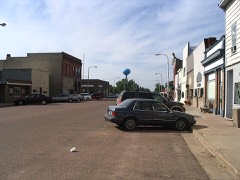 Downtown Salem Historic Districtlisted 2004
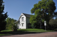 Henry Kuhle Houselisted 2008
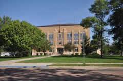 McCook County Courthouselisted 1993
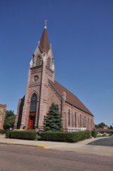 St. Mary's Catholic Churchlisted 1985
- Salem Rest Stop Tipi-Eastboundlisted 2015
- Salem Rest Stop Tipi-Westboundlisted 2015
Population over time
2 figuresSalem fell from 1,347 to 1,325 between 2010 and 2020. These are the recorded population figures Wikidata holds for this place, reached through the Geographic Names Information System number this page is keyed on rather than by name, so they belong to this place and not to another of the same name. Most are census counts, but not all are: an early figure may be a founding or settlement estimate, and an estimate published within five years of a census is left out. The change column is computed, and is left blank where more than 20 years separate a figure from the one before it, because a gap that long is not a change between two counts.
| Year | People | Change |
|---|---|---|
| 2010 | 1,347 | |
| 2020 | 1,325 | -22 (-2%) |
Topographic sheets covering this place
4 surveys from 6 printed sheetsMatched by testing this settlement's coordinate against the published boundary of every sheet in the United States Geological Survey's historical collection. Each opens the scanned sheet at the Survey.
- 1955 USGS Sioux Falls quadrangle1:250000, 3 printings
- 1958 USGS Sioux Falls quadrangle1:250000
- 1964 USGS Salem quadrangle1:24000
- 1985 USGS Salem quadrangle1:100000
Fires near this place
32 since 2002Regional context, not property-specific evidence. The federal wildfire occurrence database lists 32 fires within 5 miles of Salem between 2002 and 2020, burning about 86 acres in total. 1 started naturally. 1 was recorded as arson. Distance is straight-line from the map coordinates, so a fire counted here may appear on a neighbouring settlement's page as well.
| Reported cause | Fires |
|---|---|
| Missing data/not specified/undetermined | 13 |
| Debris and open burning | 11 |
| Equipment and vehicle use | 5 |
| Arson/incendiarism | 1 |
| Natural | 1 |
| Other causes | 1 |
The most recent of them, most recent first, with the day each was reported and the service that recorded it.
| Date | Cause | Size | Reported by | Name on the report |
|---|---|---|---|---|
| 20 September 2008 | Equipment and vehicle use | 3.2 acres | South Dakota Wildland Fire Suppression | not named |
| 6 August 2012 | Equipment and vehicle use | 1.0 acres | South Dakota Wildland Fire Suppression | TUSCHEN M&W |
| 3 August 2018 | Natural | 1.0 acres | South Dakota Wildland Fire Suppression | ERNSTER CRP |
| 25 August 2011 | Debris and open burning | 3.0 acres | South Dakota Wildland Fire Suppression | JOHN SCHEIER |
| 24 August 2011 | Missing data/not specified/undetermined | under an acre | South Dakota Wildland Fire Suppression | SCHOENEVALD |
| 4 July 2002 | Missing data/not specified/undetermined | under an acre | Salem Volunteer Fire Department | TOWNSHIP ROAD DITCH |
| 24 July 2012 | Missing data/not specified/undetermined | under an acre | South Dakota Wildland Fire Suppression | I90 #1 |
| 20 July 2014 | Other causes | 5.0 acres | South Dakota Wildland Fire Suppression | RAILROAD |
Settlements close enough to share some of these fires:
Mines and quarries near this place
3 within 5 milesRegional context, not property-specific evidence. The federal mineral resources record lists 3 workings within 5 miles of Salem: 3 producers. All of them still produce. What was taken out: Sand and Gravel, Construction. Distance is straight-line from the map coordinates, so a quarry counted here may appear on a neighbouring settlement's page as well.
| Where | Site | Commodity | Status | Recorded |
|---|---|---|---|---|
| Brown Gravel Pit | Sand and Gravel, Construction | Producer | ||
| Dexter Mobige Pit | Sand and Gravel, Construction | Producer | ||
| Fendrich Sand & Gravel Pit | Sand and Gravel, Construction | Producer |
Storms near this place
60 of 92 shownRegional context, not property-specific evidence. The National Weather Service names Salem in 92 storm reports between 1995 and 2024: 40 hail, 36 thunderstorm wind, 6 flood, 5 flash flood. The reports record 3 injuries. Each account below is quoted exactly as the forecast office filed it, from the NOAA Storm Events Database, and each date opens the federal record of that event.
| When | Event | Place named | Harm | What the report says |
|---|---|---|---|---|
| June 2024 | Thunderstorm Wind | Salem | 2 hurt | Thunderstorm winds downed several trees in Salem and tipped over a semi-truck near town which resulted in minor direct injuries. |
| April 2005 | Thunderstorm Wind | Salem | 1 hurt, $10,000 | Thunderstorm winds blew over a truck on Interstate 90, causing minor injuries to the driver. |
| September 1995 | Hail | Salem | $2,000,000 | Widespread golf ball to baseball-size hail fell with some softball size hail reported. The hail broke windows and caused other damage to all homes and unprotected vehicles in Salem, including 150 cars at a dealership. Severe damage occurred to crops in the area. |
| May 1998 | Tornado (F2) | Salem | $900,000 | no account filed |
| August 2004 | Thunderstorm Wind | Salem | $300,000 | Thunderstorm winds blew the press box off the grandstand at an athletic complex, damaged a crow's nest at the complex, and tore the roof off a mobile home. The winds also caused extensive tree damage with several trees blown down. The winds caused power line damage, resulting in a power outage. Crops in the area were damaged, especially corn, but the amount of damage was not known. Several vehicles were damaged by flying debris and windows on some buildings were broken. |
| May 2011 | Thunderstorm Wind | Salem | $100,000 | Thunderstorm winds caused tree damage and blew down power lines in Salem, causing a power outage in Salem. The winds also caused heavy damage at two farmsteads east northeast of Salem. In addition to tree damage, at least four silos, three grain bins and four machine sheds were destroyed, and four augers, a grain cart, and a grain dryer were damaged. Two surviving trees stopped one destroyed grain bin from slamming into the house on one farmstead, while the house on another farmstead suffered minor damage from debris, including a piece of lumber from one machine shed blown into the roof. |
| June 2003 | Thunderstorm Wind | Salem | $100,000 | Thunderstorm winds caused tree damage, and blew down two walls of a concrete business. |
| July 2002 | Thunderstorm Wind | Salem | $100,000 | Thunderstorm winds caused widespread tree and power line damage. Many trees were blown down, and power lines were down throughout the city with resulting power outages. Minor damage to structures, such as shingles blown off, was also reported. |
| July 2000 | Thunderstorm Wind | Salem | $100,000 | Thunderstorm winds damaged a house and garage. |
| July 2022 | Thunderstorm Wind | Salem | $50,000 | Thunderstorm winds caused significant damage to the Armory roof in Salem. |
| July 2010 | Flood | Salem | $50,000 | Heavy rain caused major flooding of the east and West Fork Vermillion Rivers, and the Little Vermillion River. Fields, lowlands, roads, and parks were flooded. the most extensive flooding in the county was reported in and near Montrose, where roads, basements, ball parks, a campground, and other low areas were flooded. Flooding threatened a sewer lift station in Montrose, but it was kept operational. |
| June 2001 | Thunderstorm Wind | Salem | $50,000 | Thunderstorm winds caused damage at several farms, including a barn blown down, farm equipment damaged, and widespread tree damage. |
| May 2016 | Lightning | Salem | $45,000 | Lightning killed 21 cattle that were gathered at a metal feeder. |
| May 2012 | Thunderstorm Wind | Salem | $10,000 | Thunderstorm winds overturned a semi truck. |
| June 1999 | Hail | Salem | $10,000 | Large hail broke windows in farm buildings and dented vehicles. |
| June 1999 | Thunderstorm Wind | Salem | $5,000 | Thunderstorm winds blew the roof off a farm structure. |
| October 1997 | Thunderstorm Wind | Salem | $3,000 | no account filed |
| July 2024 | Hail | Salem | - | Hail varied in size from ping-pong to golf ball size in Salem. |
| June 2024 | Flash Flood | Salem | - | Highway 81 south of Salem was impassable due to flooding near 257th Street. For a more comprehensive description of flood damage, please see other entries for areal and river flooding for McCook County. |
| June 2024 | Flash Flood | Salem | - | Rainfall from 2 to 4 inches in a couple of hours late evening caused significant street flooding in Salem, along with several homes with flooded basements. For a more comprehensive description of flood damage, please see other entries for areal and river flooding for McCook County. |
| July 2023 | Hail | Salem | - | Hail up to tennis ball size was reported through a photo. |
| July 2022 | Thunderstorm Wind | Salem | - | A peak thunderstorm wind gust of 78 mph was measured by a personal weather station 2 miles west of Salem. Crop damage is an estimate from insured losses. Information provided by the United States Department of Agriculture. |
| May 2022 | Hail | Salem | - | Crop damage is an estimate from insured losses. Information provided by the United States Department of Agriculture. |
| May 2022 | Thunderstorm Wind | Salem | - | Thunderstorm winds took down powerlines with the mayor reporting power out throughout Salem. |
| May 2022 | Thunderstorm Wind | Salem | - | A 40 by 60 foot outbuilding was destroyed by thunderstorm winds. The single family home next door lost some shingles and had a broken front window. |
| May 2022 | Thunderstorm Wind | Salem | - | An attached garage on a single family home was blown out and destroyed by thunderstorm winds. |
| May 2022 | Thunderstorm Wind | Salem | - | Wind was measured by hand-held anemometer. |
| May 2022 | Thunderstorm Wind | Salem | - | Multiple single family homes sustained significant damage to attached garages. |
| May 2022 | Thunderstorm Wind | Salem | - | The roof overhang on an outdoor patio at a nursing home in Salem was ripped off and tossed across an open lot to the north. A single-family home downstream of the nursing home sustained significant damage to its attached garage. At least two other outbuildings were severely damaged or destroyed. Widespread tree damage was reported across town while other single family homes sustained damage to their roofs or garages. |
| August 2021 | Hail | Salem | - | Hail varied from half-dollar to golf ball size. |
| September 2017 | Thunderstorm Wind | Salem | - | Quite a bit of tree damage. |
| July 2017 | Thunderstorm Wind | Salem | - | A willow tree was downed. |
| July 2015 | Heavy Rain | Salem | - | Heavy rainfall of 4 inches caused minimal flooding in Salem. |
| May 2013 | Heavy Rain | Salem | - | Heavy rainfall of 3.85 inches was measured. |
| May 2012 | Hail | Salem | - | Large hail covered the ground to the extent that there were drifts. Some hail was left unmelted the next morning. The hail was accompanied by heavy rainfall of 2.04 inches. No hail fell one mile north of this location. |
| May 2012 | Hail | Salem | - | Large hail covered the ground deep enough to result in drifts. |
| May 2012 | Flood | Salem | - | Heavy rain caused flooding of the Little Vermillion River, with some roads, parkland and farmland affected. The river crested at 2.12 feet above flood stage near Salem on May 7th. |
| July 2011 | Thunderstorm Wind | Salem | - | Thunderstorm winds blew down several branches. |
| June 2010 | Flash Flood | Salem | - | Heavy rain flooded streets and basements, with water from the flooded streets over sidewalks. |
| June 2010 | Thunderstorm Wind | Salem | - | Thunderstorm winds caused tree damage. The winds were accompanied by heavy rainfall of 1.50 inches. |
| March 2010 | Flood | Salem | - | Rapid melting of a heavy winter snowpack resulted in moderate to major flooding of the Little Vermillion River. Numerous fields and roads were flooded with some roads washed out. The Little Vermillion River crested at 2.3 feet above flood stage near Salem on March 14th. |
| August 2010 | Flood | Salem | - | Moderate to major flooding of the East and West Fork Vermillion Rivers, and the Little Vermillion River, triggered by late July heavy rains, continued into early August before abating. Flooding of fields, lowlands, and parks continued, then steadily abated. The most extensive flooding, reported in the Montrose area, peaked at the start of the month. Parks and campgrounds in this area were affected. |
| September 2010 | Flood | Salem | - | Heavy rain caused minor flooding of the East and West Fork Vermillion Rivers and the Little Vermillion River, with lowlands including some farmland affected. The Little Vermillion River crested at 1.2 feet above flood stage near Salem on September 24th. |
| July 2009 | Thunderstorm Wind | Salem | - | Thunderstorm winds caused an unknown amount of tree damage. |
| July 2009 | Thunderstorm Wind | Salem | - | Thunderstorm winds caused tree damage, including branches blown down in the town of Salem. |
| June 2008 | Flood | Salem | - | Heavy rain caused moderate to major flooding of the West Fork Vermillion, Little Vermillion, and Vermillion Rivers. The main damage was caused by extensive flooding of farmland. The amount of crop damage and damage to farmland from erosion was not known. Several county roads were also flooded. |
| June 2007 | Hail | Salem | - | Large hail fell at mile marker 356 on Interstate 90. |
| July 2006 | Thunderstorm Wind | Salem | - | Thunderstorm winds caused tree and power line damage, resulting in a power outage that lasted a little less than 2 hours. |
| September 2006 | Hail | Salem | - | Large hail was observed by law enforcement on Interstate 90 at mile marker 353. |
| June 2005 | Thunderstorm Wind | Salem | - | Thunderstorm winds caused tree damage, including some trees blown down. The winds also damaged a 60 foot by 80 foot outbuilding. |
| September 2005 | Flash Flood | Salem | - | Heavy rain caused flooding of roads and fields. |
| June 2003 | Flash Flood | Salem | - | Heavy rainfall caused flooding of roadways and other low areas. Minor property damage was reported but the amount of damage was not known. |
| July 2000 | Tornado (F0) | Salem | - | A brief tornado caused no reported damage. |
| July 2024 | Hail | Salem | - | no account filed |
| July 2023 | Hail | Salem | - | no account filed |
| July 2023 | Hail | Salem | - | no account filed |
| August 2021 | Hail | Salem | - | no account filed |
| July 2019 | Hail | Salem | - | no account filed |
| July 2019 | Thunderstorm Wind | Salem | - | no account filed |
| May 2012 | Hail | Salem | - | no account filed |
Nearest settlements
The eight closest, with where each one stands in the county. Distances are straight-line, computed from the Geographic Names Information System coordinates.
| Map | Place | Distance | Sheets |
|---|---|---|---|
| Golden View Colony | 3.7 miles | 6 | |
| Unityville | 6.3 miles | 6 | |
| Canistota | 10.2 miles | 6 | |
| Spencer | 10.8 miles | 11 | |
| Montrose | 11.0 miles | 6 | |
| Orland Colony | 12.0 miles | 6 | |
| Stanley Corner | 12.5 miles | 6 | |
| Bridgewater | 13.5 miles | 11 |
Elsewhere
Matched on this settlement's Geographic Names Information System number rather than its name, so it cannot be a different place of the same name in another state.
| Wikipedia article on Salem | An encyclopaedic summary. Its text is share-alike, so it is linked here rather than copied. |
| Wikidata item Q2189060 | The structured record the population and elevation above come from. Public domain (CC0). |
Provenance
This settlement is recorded in the Geographic Names Information System as feature 1257765. The sheet list is computed by point-in-boundary test against the United States Geological Survey's historical topographic inventory. Both are works of the United States government and carry no copyright under 17 U.S.C. 105.
Wildfire. Short, Karen C. 2022. Spatial wildfire occurrence data for the United States, 1992-2020 [FPA_FOD_20221014]. 6th Edition. Fort Collins, CO: Forest Service Research Data Archive. https://doi.org/10.2737/RDS-2013-0009.6 Collected with United States Government funding and usable without additional permissions or fees.
Mines and quarries. USGS Mineral Resources Data System (MRDS) https://mrdata.usgs.gov/mrds/ A work of the United States government, no copyright under 17 U.S.C. 105.
Storms. NOAA National Centers for Environmental Information, Storm Events Database https://www.ncei.noaa.gov/stormevents/ A work of the United States government, no copyright under 17 U.S.C. 105. Narratives are quoted verbatim from the National Weather Service report and are not edited or summarised.