 Block
From the record
12 National Register listings published here.
Sources: the National Register database, National Park Service
51 topographic sheets cover 28 settlements here, and 12 properties are on the National Register of Historic Places.
12 National Register listings published here.
Sources: the National Register database, National Park Service
Every property in this county listed on the National Register of Historic Places, with the year it was listed and the federal nomination document.
| Photograph | Property | Type | Listed | Reference |
|---|---|---|---|---|
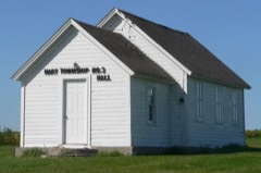 | Hart School #3 | building | 2000 | 00000994 |
| Knapp Ranch | district | 2005 | 05000282 | |
 | New Effington Hospital | building | 1989 | 89000829 |
| New Effington Rest Stop Tipi | object | 2015 | 14001189 | |
| Louis Nigg Barn | building | 2021 | 100006065 | |
 | Roberts County Courthouse | building | 1976 | 76001755 |
| Sisseton Agency Headquarters & Wacipi Grounds | site | 2022 | 100007395 | |
 | Sisseton Carnegie Library | building | 1996 | 96001227 |
| Sisseton School | building | 2020 | 100005818 | |
 | South Dakota Department of Transportation Bridge No. 55-030-418 | structure | 1999 | 99001437 |
 | Andrew and Mary Stavig House | building | 1997 | 97001392 |
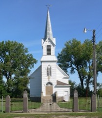 | Walla Lutheran Church | building | 2004 | 04000470 |
Every wildfire the federal occurrence database records inside this county: 262 of them, burning about 4,095 acres. 10 started naturally and 10 were recorded as arson. Each settlement page carries the fires within five miles of it.
| Reported cause | Fires |
|---|---|
| Debris and open burning | 97 |
| Missing data/not specified/undetermined | 56 |
| Misuse of fire by a minor | 34 |
| Equipment and vehicle use | 21 |
| Fireworks | 14 |
| Smoking | 12 |
| Arson/incendiarism | 10 |
| Natural | 10 |
| Recreation and ceremony | 4 |
| Power generation/transmission/distribution | 3 |
| Other causes | 1 |
The five largest, by the area the report gives. None of them was recorded as arson.
| Date | Cause | Size | Reported by | Name on the report |
|---|---|---|---|---|
| 12 April 2003 | Debris and open burning | 280 acres | Waubay National Wildlife Refuge | DANIELSON |
| 21 October 1999 | Debris and open burning | 240 acres | South Shore Volunteer Fire Department | WOHLLEBER |
| 5 April 2000 | Debris and open burning | 200 acres | Corona Volunteer Fire Department | SODAK |
| 16 March 1992 | Smoking | 200 acres | Sisseton Agency | not named |
| 8 April 1996 | Debris and open burning | 160 acres | Sisseton Agency | LBAR |
| 19 May 2009 | Debris and open burning | 153 acres | South Dakota Wildland Fire Suppression | not named |
| 2 April 2003 | Missing data/not specified/undetermined | 150 acres | South Dakota Wildland Fire Suppression | ARTER |
| 6 October 2011 | Missing data/not specified/undetermined | 150 acres | South Dakota Wildland Fire Suppression | BRYCE HEINJE |
Every settlement page carries the fires within five miles of it - see the settlement index below.
The NOAA Storm Events Database holds 341 reports for this county, causing 1 death, 1 injury and about $4,589,530 in recorded property damage. Each settlement page carries the reports that name it.
| Kind of event | Reports |
|---|---|
| Thunderstorm Wind | 139 |
| Hail | 132 |
| Tornado | 32 |
| Flood | 24 |
| Flash Flood | 12 |
| Funnel Cloud | 2 |
The most serious of them, by death, then injury, then recorded damage. The accounts are quoted exactly as the forecast office filed them.
| When | Event | Place named | Harm | What the report says |
|---|---|---|---|---|
| June 1979 | Tornado (F1) | not stated | 1 killed, $2,500,000 | no account filed |
| July 1951 | Tornado (F2) | not stated | 1 hurt | no account filed |
| May 1994 | Hail | Milbank | $500,000 | Widespread hail and strong winds broke many windows, damaged vehicles, ruined crops, stripped many trees, and wrecked outdoor lights. |
| May 1994 | Thunderstorm Wind | to Wilmot | $500,000 | Widespread hail and strong winds broke many windows, damaged vehicles, ruined crops, stripped many trees, and wrecked outdoor lights. |
| August 1979 | Tornado (F2) | not stated | $250,000 | no account filed |
| October 1994 | Tornado (F1) | to 7NE of | $200,000 | A tornado destroyed several small farm buildings, a garage, damaged farm machinery, blew down a grain bin, and uprooted several trees. Several hogs were killed when their shed was destroyed and minor damage was done to some homes. The tornado drove a 6 foot long 1x6 piece of lumber through the center of a large tree limb. |
| April 2019 | Flood | Dahlberg | $191,000 | no account filed |
| April 2023 | Flood | Dahlberg | $150,000 | no account filed |
| June 2008 | Flash Flood | Goodwill | $100,000 | no account filed |
| June 2025 | Flash Flood | Ortley | $50,000 | Emergency management reports several county and township roads under water, in addition to the number of streets under water in the city of Sisseton. Flooding would impact numerous businesses, including Lakes Gas, where about 40 propane tanks were observed floating in flood waters. Numerous cars were also inundated by these flood waters. |
| May 1994 | Hail | Sisseton | $50,000 | The hail broke many windows and caused other damage to houses and vehicles. |
| July 1974 | Tornado (F0) | not stated | $25,000 | no account filed |
| June 1967 | Tornado (F1) | not stated | $25,000 | no account filed |
| May 1964 | Tornado (F2) | not stated | $25,000 | no account filed |
| May 1994 | Hail | Sisseton | $5,000 | Several trees were downed by winds. |
| May 1994 | Thunderstorm Wind | Sisseton | $5,000 | Several trees were downed by winds. |
| August 2009 | Flash Flood | Ortley | $5,000 | no account filed |
| June 1988 | Tornado (F0) | not stated | $2,500 | no account filed |
| June 1975 | Tornado (F0) | not stated | $2,500 | no account filed |
| July 1972 | Tornado (F1) | not stated | $2,500 | no account filed |
| August 1994 | Tornado (F0) | New Effington | $1,000 | The tornado uprooted trees and damaged a corn planter. |
| June 1992 | Tornado (F1) | not stated | $30 | no account filed |
| June 2025 | Flood | Summit | - | The South Dakota Department of Transportation reported water over the roadway. |
| July 2025 | Thunderstorm Wind | Summit | - | A peak gust of 77 mph was recorded by the South Dakota Department of Transportation mesonet station one mile north-northwest of Summit. |
| July 2025 | Thunderstorm Wind | Wilmot | - | A COOP observer in Wilmot relayed that several large tree branches were downed around town by the thunderstorm winds. |
| July 2025 | Thunderstorm Wind | Hammer | - | The caller stated that their calf shelters were thrown into the fence by estimated 65 mph wind gusts. |
| July 2025 | Thunderstorm Wind | Rosholt | - | A farmer estimated winds up to 60 mph in combination with the hail caused scattered crop damage. |
| July 2025 | Thunderstorm Wind | Peever | - | A trained spotter estimated winds up to 60 mph were responsible for some minor tree damage, including a few branches down. |
| August 2025 | Thunderstorm Wind | Goodwill | - | Thunderstorm wind gusts estimated at 60 mph resulted in broken branches. |
| August 2025 | Flash Flood | Peever | - | Roberts County Emergency Management reports that barricades were required at several locations where water has come up over highways and secondary roads, from portions of highway 15 near Wilmot all the way up to 123rd St 3 miles north of Agency Village. |
| July 2024 | Thunderstorm Wind | Claire City | - | Emergency management reported broken windows due to blow debris from thunderstorm winds. |
| July 2024 | Thunderstorm Wind | Rosholt | - | A trained spotter estimated 60 mph thunderstorm wind gusts had caused tree damage with a number of branches down. |
| April 2023 | Flood | Wilmot | - | Flooding along the northern reaches of the North Fork Whetstone inundated the northern and western portions of Wilmot on April 11th. |
| June 2023 | Thunderstorm Wind | Sisseton Arpt | - | An Automated Surface Observation Station three miles east of Sisseton recorded a wind gusts of 61 mph. |
| June 2023 | Tornado (EF0) | Peever | - | The report of a brief landspout tornado came with a photograph. |
| August 2023 | Thunderstorm Wind | Ortley | - | A heavy wooden trailer with a water tank on it was blown approximately 150 yards across two ditches before hitting a neighbors house. |
| May 2022 | Tornado (EF0) | New Effington | - | Eyewitnesses observed a brief tornado touchdown. No damage|occurred. |
| May 2022 | Thunderstorm Wind | Rosholt | - | Trees were downed across Rosholt by estimated 80 mph wind gusts. |
| May 2022 | Thunderstorm Wind | Sisseton Arpt | - | Campers were rolled by estimated 80 mph wind gusts. |
| May 2022 | Thunderstorm Wind | Ortley | - | Trees were uprooted in Ortley by estimated 75 mph winds. |
| July 2022 | Thunderstorm Wind | Sisseton | - | The Emergency Manager reported several trees and power lines down due to the thunderstorm winds. |
| July 2022 | Thunderstorm Wind | Sisseton | - | A COOP observer reported an estimated wind gust of 60 mph. |
| July 2022 | Thunderstorm Wind | Peever | - | An estimated 60 mph wind gust was reported by the public. |
| September 2022 | Thunderstorm Wind | Peever | - | This report was recorded at mesonet station 143 six miles south-southwest of Peever. |
| September 2022 | Thunderstorm Wind | Summit | - | This report was recorded at mesonet station 55 a milee west-northwest of Summit. |
| July 2021 | Thunderstorm Wind | Peever | - | Estimated 60 mph winds caused minor tree damage with a few limbs up to 5 inches in diameter broken off. |
| July 2021 | Thunderstorm Wind | Sisseton | - | An apple tree was knocked over by estimated 60 mph winds. |
| October 2021 | Tornado (EF0) | Wilmot | - | A tornado touched down briefly. |
| October 2021 | Tornado (EF0) | Goodwill | - | A trained spotter reported a tornado lasting about 5 minutes. |
| October 2021 | Tornado (EF0) | Corona | - | A trained spotter reported a tornado/waterspout on Big Stone Lake. |
| October 2021 | Thunderstorm Wind | Peever | - | A 30-foot trailer pulled by a pickup truck was overturned on Interstate-29 by estimated 70 mph winds. |
| July 2020 | Thunderstorm Wind | Claire City | - | Estimated seventy-five mph winds downed many trees along with causing some power outages in Claire City. |
| July 2020 | Thunderstorm Wind | New Effington | - | Several trees were downed by estimated seventy-five mph winds in New Effington. |
| July 2020 | Thunderstorm Wind | Sisseton | - | Estimated seventy mph winds downed several trees along with causing some power outages in Sisseton. |
| July 2020 | Thunderstorm Wind | Peever | - | Several trees were downed in Peever by estimated seventy mph winds. |
| March 2019 | Flood | Dahlberg | - | Many roads were flooded throughout Roberts county. Up to sixty residential, nonresidential, and public buildings were threatened or received some flooding. The city of Corona was surrounded by water and had water in town with several houses taking on water. They cut three county roads to evacuate water out of town. The Sisseton-Wahpeton Oyate signed an emergency declaration along with Roberts county. |
| August 2019 | Thunderstorm Wind | New Effington | - | Large branches were downed by estimated sixty mph winds. |
| September 2019 | Thunderstorm Wind | Wilmot | - | Estimated sixty mph winds brought down some large branches in Wilmot. |
| June 2018 | Tornado (EF0) | Hammer | - | A tornado touched down briefly southeast of Claire City with no damage occurring. |
| June 2018 | Flash Flood | Hammer | - | Heavy rains of 2 to 4 inches brought flash flooding in and to the east and southeast of Claire City. Several roads were flooded along with several basements in Claire City. |
The Survey's mineral resources record lists 12 workings inside this county. 11 still produce and 1 is closed or unrecorded. Each settlement page carries the workings within five miles of it.
| Commodity | Workings |
|---|---|
| Sand and Gravel, Construction | 12 |
The least common of them first, because a county's hundredth gravel pit says nothing its first ten did not.
| Where | Site | Commodity | Status | Recorded |
|---|---|---|---|---|
| Barlund Sand & Gravel Co Pit | Sand and Gravel, Construction | Producer | ||
| Braun Pit #1 | Sand and Gravel, Construction | Producer | ||
| Braun Pit #2 | Sand and Gravel, Construction | Producer | ||
| Dan Brown Pit | Sand and Gravel, Construction | Producer | ||
| Gravel Pit | Sand and Gravel, Construction | Producer | ||
| Helwig Pit | Sand and Gravel, Construction | Producer | ||
| Kaufman Pit & Mill | Sand and Gravel, Construction | Producer | ||
| Lotzer Sand Pit | Sand and Gravel, Construction | Producer | ||
| Markaseth Pit | Sand and Gravel, Construction | Producer | ||
| Seebeck Pit | Sand and Gravel, Construction | Producer | ||
| Whiterock Colony Pit | Sand and Gravel, Construction | Producer | ||
| Wollschlager Pit | Sand and Gravel, Construction | Past Producer |
Named settlements recorded in the Geographic Names Information System, each with the topographic sheets covering it. Villages, hamlets and abandoned places alike. Each is shown with the nearest named watercourse or landform and the survey quadrangle it falls on.
Harmon township · 57260 · Near Skunk Island · Beardsley NW quadrangle
13 sheets, 1916 to 1985
Geneseo township · 57227 · On Hartford Beach Creek · Big Stone Lake West quadrangle
8 sheets, 1953 to 1985
Long Hollow township · 57262 · Whitestone Lake quadrangle
6 sheets, 1953 to 1979
Lawrence township · 57257 · On Big Spring Creek · Peever quadrangle
12 sheets, 1916 to 1985
Lake township · 57279 · On Hartford Beach Creek · Big Stone Lake West quadrangle
8 sheets, 1953 to 1985