 Block
From the record
5 National Register listings published here.
Sources: the National Register database, National Park Service
24 topographic sheets cover 11 settlements here, and 5 properties are on the National Register of Historic Places.
5 National Register listings published here.
Sources: the National Register database, National Park Service
Every property in this county listed on the National Register of Historic Places, with the year it was listed and the federal nomination document.
| Photograph | Property | Type | Listed | Reference |
|---|---|---|---|---|
 | E. G. Barnum House | building | 1983 | 83003020 |
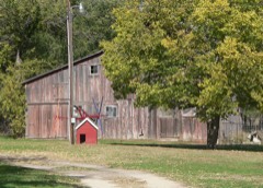 | Manthey Barn | building | 2004 | 03001533 |
| South Dakota Dept. of Transportation Bridge No. 62-220-512 | structure | 1993 | 93001321 | |
 | Tripp County Veteran's Memorial | object | 2009 | 09000947 |
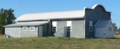 | Wewela Hall | building | 2010 | 10000952 |
Every wildfire the federal occurrence database records inside this county: 275 of them, burning about 8,669 acres. 43 started naturally and 6 were recorded as arson. Each settlement page carries the fires within five miles of it.
| Reported cause | Fires |
|---|---|
| Missing data/not specified/undetermined | 111 |
| Debris and open burning | 45 |
| Natural | 43 |
| Equipment and vehicle use | 35 |
| Misuse of fire by a minor | 17 |
| Fireworks | 9 |
| Arson/incendiarism | 6 |
| Power generation/transmission/distribution | 5 |
| Smoking | 2 |
| Other causes | 1 |
| Recreation and ceremony | 1 |
The five largest, by the area the report gives. One of them was set deliberately.
| Date | Cause | Size | Reported by | Name on the report |
|---|---|---|---|---|
| 18 September 2000 | Natural | 1,500 acres | Winner Volunteer Fire Department | NOVOTNY AND WAGNER |
| 18 September 2000 | Natural | 1,000 acres | Winner Volunteer Fire Department | FOSTER AND NOVOTNY |
| 11 July 2012 | Missing data/not specified/undetermined | 500 acres | South Dakota Wildland Fire Suppression | MUTUAL AID TO WINNER |
| 11 March 2006 | Debris and open burning | 403 acres | Rosebud Agency | MOISAN |
| 21 September 2000 | Equipment and vehicle use | 350 acres | Winner Volunteer Fire Department | AHLMAN AND DOCKER |
| 18 September 2000 | Natural | 350 acres | Dallas Volunteer Fire Department | VIADOCK ROAD EKTORH |
| 18 March 2011 | Natural | 342 acres | Rosebud Agency | DIAMOND RANCH |
| 7 March 2006 | Arson/incendiarism | 300 acres | South Dakota Wildland Fire Suppression | not named |
Every settlement page carries the fires within five miles of it - see the settlement index below.
The NOAA Storm Events Database holds 595 reports for this county, causing no deaths, 3 injuries and about $4,905,530 in recorded property damage. Each settlement page carries the reports that name it.
| Kind of event | Reports |
|---|---|
| Hail | 282 |
| Thunderstorm Wind | 246 |
| Tornado | 35 |
| Flood | 19 |
| Flash Flood | 9 |
| Funnel Cloud | 2 |
| Heavy Rain | 1 |
| Wildfire | 1 |
The most serious of them, by death, then injury, then recorded damage. The accounts are quoted exactly as the forecast office filed them.
| When | Event | Place named | Harm | What the report says |
|---|---|---|---|---|
| May 1965 | Tornado (F5) | not stated | 1 hurt, $2,500,000 | no account filed |
| May 2010 | Hail | Colome | 1 hurt, $600,000 | Golfball to baseball sized hail damaged homes and automobiles in Colome. A woman was hit in the head by a hail stone. |
| July 1998 | Funnel Cloud | Winner | 1 hurt | FUNNEL CLOUDS CONTINUED AS THE STORMS MOVED INTO TRIPP COUNTY. |
| June 1994 | Thunderstorm Wind | Winner | $500,000 | Several structures were damaged with broken windows and shingles torn off. The roof was blown off a bingo hall, and a mobile home was destroyed. |
| June 2009 | Thunderstorm Wind | Winner | $300,000 | Wind gusts to 75 mph downed numerous power poles and trees across south central Tripp County. A few small barns and sheds were also blown over by the wind. The combination of hail and wind destroyed siding on a house south of Winner and flattened crops. |
| June 2008 | Flash Flood | Colome | $250,000 | no account filed |
| June 2004 | Flash Flood | Winner | $200,000 | no account filed |
| August 2003 | Thunderstorm Wind | Winner | $100,000 | no account filed |
| May 2010 | Tornado (EF2) | Winner | $80,000 | A tornado tracked along East 3rd Street in Winner, blowing down carports, trees, and tractor-trailers. A large barn was destroyed east of Winner; the curved roof was blown off in one piece and tossed across a corral. Another machine shed was blown apart. Based on the extent of the damage, wind speeds were estimated around 75 mph through town with peak winds 95 to 115 mph. |
| June 2003 | Hail | Winner | $50,000 | Large hail broke car windows. |
| August 2011 | Hail | Clearfield | $50,000 | no account filed |
| June 2024 | Flash Flood | Colome | $30,000 | Runoff from heavy rain caused flash flooding. At least 12 county roads were inundated with water and debris. The hardest hit areas were around Witten, Winner, and Hamill. |
| May 2016 | Tornado (EF1) | Clearfield | $25,000 | A brief tornado touched down north of Clearfield in southwestern Tripp County and tracked across a farm, causing considerable property damage. Two livestock trailers were tossed by the winds estimated near 100 mph. A pole shed was destroyed with the poles torn from the ground and metal siding and roof blown across the yard. The home had roof and siding damage. Two power poles were downed. There were no injuries. |
| September 1968 | Tornado (F1) | not stated | $25,000 | no account filed |
| August 1967 | Tornado (F1) | not stated | $25,000 | no account filed |
| June 1957 | Tornado (F2) | not stated | $25,000 | no account filed |
| July 2010 | Thunderstorm Wind | Witten | $20,000 | Wind gusts broke branches ten inch in diameter off trees. |
| August 2009 | Hail | Hamill | $15,000 | no account filed |
| May 2016 | Flash Flood | Keyapaha | $10,000 | Street flooding occurred in Colome and several county roads in southeastern Tripp County were flooded. |
| July 2013 | Flood | Witten | $10,000 | Heavy rain caused Cottonwood Creek, Two Nations Creek, and Little Dog Creek in northwestern Tripp County and Sand Creek in southwestern Tripp County to overflow. Highway 44 was flooded in six locations and numerous county roads were damaged. |
| May 2010 | Hail | Millboro | $10,000 | Hail caused minor damage to homes and automobiles. |
| June 2006 | Thunderstorm Wind | Winner | $10,000 | 3 power poles were downed in Winner. |
| July 1999 | Thunderstorm Wind | Winner | $10,000 | Nine power poles and several large trees were blown down. |
| May 2016 | Thunderstorm Wind | Colome | $5,000 | Thunderstorm winds destroyed a small shed, blowing the debris across a field almost a mile. A semi truck and trailer were tipped over. Time was estimated from radar. |
| May 2010 | Hail | Carter | $5,000 | Golfball sized hail broke windows and skylights. |
| June 1999 | Thunderstorm Wind | Winner | $5,000 | Wind damage from a thunderstorm. A convenience store roof was damaged, power lines were down and several large trees were blown over. |
| June 2003 | Tornado (F1) | Winner | $5,000 | no account filed |
| June 2001 | Tornado (F1) | Winner | $5,000 | no account filed |
| June 2009 | Hail | Witten | $4,000 | no account filed |
| July 2009 | Tornado (EF1) | Clearfield | $3,000 | A small tornado trouched down on a farm west of the intersection of 286th Street and 313th Avenue. The tornado blew a garage off its foundation, tipped over a combine, and snapped large cottonwood trees. Event times were estimated from radar data. |
| August 2002 | Thunderstorm Wind | Hamill | $3,000 | Severe thunderstorm wind gusts damaged a roof. |
| August 2009 | Hail | Colome | $3,000 | no account filed |
| April 1985 | Tornado (F1) | not stated | $2,500 | no account filed |
| April 1957 | Tornado (F2) | not stated | $2,500 | no account filed |
| May 2016 | Thunderstorm Wind | Keyapaha | $2,000 | Strong winds caused roof damage to farm buildings. |
| July 2015 | Thunderstorm Wind | Ideal | $2,000 | The roof of the old school house was blown off. |
| May 2010 | Hail | Keyapaha | $2,000 | Two inches of rain also fell. |
| July 2009 | Tornado (EF1) | Clearfield | $2,000 | A small tornado tracked across Dog Ear Township from 311th Avenue to near the intersection of 289th Street and 312th Avenue. The tornado blew down large cottonwood trees. Event times were estimated from radar data. |
| September 2000 | Thunderstorm Wind | Winner | $2,000 | An awning was torn off a building in Winner. |
| August 2024 | Thunderstorm Wind | Winner | $1,000 | Shingles were blown off of roof and five inch diameter tree branches broken off of trees. |
| June 2024 | Flood | Hamill | $1,000 | Runoff from an estimated 3 to 5 inches of rain in less than 24 hours caused minor flooding along the White River. Agricultural land along the White River was inundated with water and debris. The White River near Oacoma river gage crested at 16.07 feet and 12,800 cfs at 215 AM CST. |
| August 2017 | Hail | Winner | $1,000 | The combination of hail and wind broke a window in a home. |
| July 2015 | Flash Flood | Ideal | $1,000 | A section of US Highway 183 was washed out. |
| June 2011 | Thunderstorm Wind | Ideal | $1,000 | The strong winds moved an empty stock tank, stripped roofing tin from a building, and broke small branches on trees. |
| July 2000 | Thunderstorm Wind | Colome | $1,000 | Several 300 pound hog feeders were blown over and damaged. |
| May 1998 | Hail | Colome | $1,000 | Hail broke two house windows . |
| July 2001 | Thunderstorm Wind | Winner | $500 | A thunderstorm over Winner produced a heat burst with damaging winds. Temperatures at the Winner airport jumped to 92F. One power pole was blown down. |
| August 1982 | Tornado (F0) | not stated | $30 | no account filed |
| June 2025 | Thunderstorm Wind | Witten | - | SD mesonet recorded wind gust. |
| June 2025 | Thunderstorm Wind | Wewela | - | SD mesonet recorded wind gust. |
| July 2025 | Thunderstorm Wind | (Icr)Winner Airport | - | ASOS recorded wind gust. |
| July 2025 | Thunderstorm Wind | Witten | - | SD Mesonet recorded wind gust. |
| July 2025 | Thunderstorm Wind | Witten | - | SD Mesonet recorded wind gust. |
| July 2025 | Thunderstorm Wind | Witten | - | SD Mesonet recorded wind gust. |
| July 2025 | Hail | Winner Arpt | - | Trained spotter reported small hail and winds gusting 40 to 50 mph as well. |
| July 2025 | Hail | Winner Arpt | - | Spotter submitted hail report. |
| July 2025 | Hail | Winner Arpt | - | Public submitted report via social media. |
| July 2025 | Thunderstorm Wind | (Icr)Winner Airport | - | ASOS recorded wind gust. |
| July 2025 | Thunderstorm Wind | (Icr)Winner Airport | - | ASOS confirmed wind gust. |
| July 2025 | Hail | Clearfield | - | Storm chaser report. |
The Survey's mineral resources record lists 15 workings inside this county. 3 still produce and 12 are closed or unrecorded. Each settlement page carries the workings within five miles of it.
| Commodity | Workings |
|---|---|
| Sand and Gravel, Construction | 12 |
| Stone, Crushed/Broken | 2 |
| Stone | 1 |
The least common of them first, because a county's hundredth gravel pit says nothing its first ten did not.
| Where | Site | Commodity | Status | Recorded |
|---|---|---|---|---|
| Woidneck Pit | Stone | Producer | ||
| Carlson Battelyoun Butte Pit | Stone, Crushed/Broken | Past Producer | ||
| Carlson's Red Butte Quarry | Stone, Crushed/Broken | Producer | ||
| Gravel Pit | Sand and Gravel, Construction | Past Producer | ||
| Gravel Pit | Sand and Gravel, Construction | Past Producer | ||
| Gravel Pit | Sand and Gravel, Construction | Past Producer | ||
| Gravel Pit | Sand and Gravel, Construction | Past Producer | ||
| Gravel Pit | Sand and Gravel, Construction | Past Producer | ||
| Gravel Pit | Sand and Gravel, Construction | Past Producer | ||
| Gravel Pit 11n | Sand and Gravel, Construction | Past Producer | ||
| Gravel Pit No 10 | Sand and Gravel, Construction | Prospect | ||
| Gravel Pit No 12 | Sand and Gravel, Construction | Past Producer | ||
| Gravel Pit No. 115 | Sand and Gravel, Construction | Producer | ||
| Pit No 13 | Sand and Gravel, Construction | Past Producer | ||
| Rosebud Sioux Gravel Pit 2842 | Sand and Gravel, Construction | Past Producer |
Named settlements recorded in the Geographic Names Information System, each with the topographic sheets covering it. Villages, hamlets and abandoned places alike. Each is shown with the nearest named watercourse or landform and the survey quadrangle it falls on.