 Block
From the record
10 National Register listings published here.
Sources: the National Register database, National Park Service
25 topographic sheets cover 7 settlements here, and 10 properties are on the National Register of Historic Places.
10 National Register listings published here.
Sources: the National Register database, National Park Service
Every property in this county listed on the National Register of Historic Places, with the year it was listed and the federal nomination document.
| Photograph | Property | Type | Listed | Reference |
|---|---|---|---|---|
 | Brown Palace Hotel | building | 1983 | 83003022 |
 | A. H. Brown Public Library | building | 1978 | 78002573 |
| Brown-Evans House | building | 1990 | 90000960 | |
| Java Depot | building | 2001 | 01000640 | |
| Johnson Barn | building | 2005 | 05000950 | |
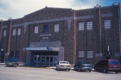 | Mobridge Auditorium | building | 1986 | 86001189 |
 | Mobridge Masonic Temple | building | 1977 | 77001259 |
| Molstad Lake Park | district | 2010 | 10000953 | |
 | Selby Opera House | building | 1987 | 87001730 |
 | Walworth County Courthouse | building | 1999 | 99000680 |
Every wildfire the federal occurrence database records inside this county: 69 of them, burning about 4,985 acres. 7 started naturally and 1 was recorded as arson. Each settlement page carries the fires within five miles of it.
| Reported cause | Fires |
|---|---|
| Missing data/not specified/undetermined | 34 |
| Equipment and vehicle use | 12 |
| Debris and open burning | 8 |
| Natural | 7 |
| Other causes | 2 |
| Railroad operations and maintenance | 2 |
| Smoking | 2 |
| Misuse of fire by a minor | 1 |
| Arson/incendiarism | 1 |
The five largest, by the area the report gives. None of them was recorded as arson.
| Date | Cause | Size | Reported by | Name on the report |
|---|---|---|---|---|
| 6 July 2006 | Railroad operations and maintenance | 2,500 acres | South Dakota Wildland Fire Suppression | 1804 |
| 4 November 1999 | Equipment and vehicle use | 1,000 acres | Mobridge Volunteer Fire Department | GRASS 6 |
| 21 August 2001 | Equipment and vehicle use | 400 acres | Lowry Volunteer Fire Department | RITTER |
| 1 May 2001 | Other causes | 350 acres | Mound City Volunteer Fire Department | HARLAN KRAUSE |
| 12 April 2015 | Missing data/not specified/undetermined | 200 acres | South Dakota Wildland Fire Suppression | TOWER HILL |
| 14 February 2000 | Debris and open burning | 75 acres | Hoven Volunteer Fire Department | RON ANBUSH |
| 2 June 2009 | Equipment and vehicle use | 70 acres | South Dakota Wildland Fire Suppression | not named |
| 27 September 2012 | Missing data/not specified/undetermined | 60 acres | South Dakota Wildland Fire Suppression | ROCK |
Every settlement page carries the fires within five miles of it - see the settlement index below.
The NOAA Storm Events Database holds 410 reports for this county, causing no deaths, 2 injuries and about $3,921,050 in recorded property damage. Each settlement page carries the reports that name it.
| Kind of event | Reports |
|---|---|
| Thunderstorm Wind | 187 |
| Hail | 177 |
| Tornado | 28 |
| Flash Flood | 8 |
| Flood | 7 |
| Funnel Cloud | 3 |
The most serious of them, by death, then injury, then recorded damage. The accounts are quoted exactly as the forecast office filed them.
| When | Event | Place named | Harm | What the report says |
|---|---|---|---|---|
| June 1964 | Tornado (F2) | not stated | 2 hurt, $25,000 | no account filed |
| May 2018 | Flash Flood | Java | $3,000,000 | no account filed |
| April 2019 | Flood | Akaska | $292,300 | no account filed |
| June 1978 | Tornado | not stated | $250,000 | no account filed |
| June 1961 | Tornado (F2) | not stated | $250,000 | no account filed |
| July 1994 | Thunderstorm Wind | Selby | $50,000 | Thunderstorm Winds destroyed a garage and some trees on a farm. |
| July 1970 | Tornado (F1) | not stated | $25,000 | no account filed |
| July 1959 | Tornado (F2) | not stated | $25,000 | no account filed |
| June 1971 | Tornado (F1) | not stated | $2,500 | no account filed |
| June 1994 | Thunderstorm Wind | Java | $500 | A large maple tree was blown down. |
| July 1991 | Tornado (F0) | not stated | $250 | no account filed |
| August 1986 | Tornado (F1) | not stated | $250 | no account filed |
| April 1955 | Tornado (F1) | not stated | $250 | no account filed |
| July 2025 | Thunderstorm Wind | Selby | - | An mPING report indicated estimated 60 mph winds, which resulted in broken branches, damaged power lines, and shifted poles. |
| July 2025 | Thunderstorm Wind | Selby | - | The caller stated wind gusts had topped out around 60 mph. |
| July 2025 | Thunderstorm Wind | Mobridge | - | In Mobridge, powerful thunderstorm winds broke three power poles. The roof of a business, which had been previously damaged, was completely ripped off. The nearby Automated Surface Observing System at the Mobridge Regional Airport reported a gust of 61 mph. |
| July 2025 | Thunderstorm Wind | Sitka | - | A peak wind gust of 63 mph was observed by a South Dakota State University mesonet station in the town of Glenham. |
| July 2025 | Thunderstorm Wind | Lowry | - | A peak wind gust of 76 mph was measured by the South Dakota Department of Transportation weather station two miles south of Lowry. |
| September 2025 | Tornado (EF1) | Glenham | - | The tornado tracked north-northwest over mainly open country near the city of Mobridge. This tornado initially hit a farmstead where damage was observed to a grain silo. It then tipped two semi-trailers on SD Highway 1804. The tornado destroyed an outbuilding at another farmstead located a mile south of US Highway 12. As the tornado crossed US Highway 12, it overturned a camper being pulled by a vehicle and bent a power pole. After crossing US Highway 12, the tornado tracked just west of 290th Avenue, taking down a series of six power poles that were either completely broken or severely bent before the tornado dissipated. |
| September 2025 | Thunderstorm Wind | (Y26)Mobridge Arpt | - | The Walworth County Emergency Manager estimated the wind speed to top out between 60 to 70 mph as the storm passed through after the ASOS lost power. |
| June 2024 | Thunderstorm Wind | Glenham | - | A national weather service employee estimated the wind speeds between 60 and 70 mph. |
| June 2023 | Thunderstorm Wind | Sitka | - | A member of the public reported a wind gust of 60 mph 5 miles west of Selby. |
| April 2022 | Thunderstorm Wind | Lowry | - | Wind destroyed a large outbuilding/chicken coop. |
| April 2022 | Thunderstorm Wind | Glenham | - | Damage to brick roof/facade on the old school building. |
| July 2020 | Thunderstorm Wind | Mobridge | - | Estimated seventy mph winds brought some power lines down in Mobridge. |
| July 2020 | Thunderstorm Wind | Glenham | - | Sixty mph winds were estimated. |
| July 2020 | Thunderstorm Wind | Glenham | - | Sixty-five mph winds were estimated. |
| July 2020 | Thunderstorm Wind | Selby | - | Seventy mph winds were estimated. |
| June 2020 | Thunderstorm Wind | Glenham | - | An estimated eighty mph wind destroyed a ten unit storage shed. The back wall was pushed over with metal spread downwind up to a quarter mile. The boats inside were not moved. |
| March 2019 | Flood | Java | - | Several roads were flooded in the county. |
| August 2019 | Hail | Java | - | Golf ball to baseball size hail broke home and vehicle windows. |
| August 2019 | Hail | Lowry | - | Half dollar size hail caused some garden and crop damage. |
| August 2019 | Hail | Java Jct | - | Golf ball to baseball size hail along with severe winds brought a destructive path of crops from northwest of Java to Java during the evening hours. The path width was anywhere from 2 to 5 miles. The destruction was shown on satellite. |
| August 2019 | Thunderstorm Wind | Selby | - | Sixty mph winds were estimated with quarter size hail. |
| August 2019 | Thunderstorm Wind | Java | - | Sixty mph winds were estimated. |
| July 2019 | Thunderstorm Wind | Lowry | - | Sixty mph winds were estimated. |
| July 2019 | Thunderstorm Wind | Akaska | - | Estimated sixty mph winds brought down several large tree branches. |
| July 2018 | Thunderstorm Wind | (Y26)Mobridge Arpt | - | Several campers were overturned along with many boats damaged at the marina as estimated ninety mph winds occurred. There were people in the campers that were rescued with no injuries reported. There was also roof damage to a building near the marina. |
| July 2018 | Thunderstorm Wind | Mobridge | - | Estimated ninety mph winds downed numerous trees and tree branches in Mobridge along with causing some property damage. Some fences and outside furniture were damaged along with several homes and businesses. There were signs blown over, windows blown out, along with several reports of vehicle damage. The electricity was also out on the east side of town for awhile. The cover of a storage building was ripped off along with the roof of a hanger at the airport. |
| June 2018 | Tornado (EF0) | Glenham | - | A tornado touched downed briefly just northeast of Glenham. No damage was reported. |
| May 2018 | Flash Flood | Selby | - | Due to the very heavy rainfall earlier, the dam at Lake Hiddenwood broke in the early morning hours spreading water northwest through a creek. Several roads were flooded along with crop and pastureland. The earthen dam was built in 1927 and was 27 feet high with a concrete spillway. The bridge over the spillway was also destroyed. The lake was one of the first artificial lakes in South Dakota. Lake Hiddenwood State Park was closed indefinitely. |
| May 2018 | Flood | Glenham | - | Flooding continued through the night and through the next day across the region. Agricultural land along with many roads were flooded. |
| May 2018 | Thunderstorm Wind | Java | - | Sixty mph winds were estimated. |
| July 2017 | Thunderstorm Wind | Selby | - | Seventy mph winds were estimated. |
| July 2017 | Thunderstorm Wind | Java | - | Seventy mph winds were estimated. |
| July 2017 | Thunderstorm Wind | Akaska | - | Sixty mph winds were estimated. |
| July 2017 | Thunderstorm Wind | Akaska | - | Sixty mph winds were estimated. |
| May 2016 | Thunderstorm Wind | Akaska | - | A large cottonwood tree was downed by seventy mph winds. |
| August 2016 | Thunderstorm Wind | Selby | - | Sixty mph winds were estimated. |
| August 2016 | Thunderstorm Wind | Java Jct | - | Seventy mph winds downed several trees along with many branches at Lake Hiddenwood. |
| August 2016 | Thunderstorm Wind | Mobridge | - | Sixty-five mph winds were estimated. |
| August 2016 | Thunderstorm Wind | Selby | - | Seventy mph winds were estimated. |
| August 2016 | Thunderstorm Wind | Selby | - | An estimated sixty mph wind occurred at Selby. |
| July 2016 | Thunderstorm Wind | Mobridge | - | Sixty mph winds brought tree limbs down. |
| July 2016 | Thunderstorm Wind | Mobridge | - | Seventy mph winds were estimated. |
| July 2016 | Thunderstorm Wind | Akaska | - | Sixty mph winds were estimated. |
| July 2016 | Thunderstorm Wind | (Y26)Mobridge Arpt | - | Seventy mph winds downed some power lines and many tree limbs in Mobridge. |
| July 2016 | Thunderstorm Wind | Akaska | - | Sixty mph winds were estimated. |
| June 2015 | Thunderstorm Wind | Selby | - | Sixty mph winds were estimated. |
| August 2015 | Hail | Lowry | - | Hail damaged some door screens. |
The Survey's mineral resources record lists 1 working inside this county. It still produces. Each settlement page carries the workings within five miles of it.
| Commodity | Workings |
|---|---|
| Sand and Gravel, Construction | 1 |
The least common of them first, because a county's hundredth gravel pit says nothing its first ten did not.
| Where | Site | Commodity | Status | Recorded |
|---|---|---|---|---|
| Jensen Mill Pit | Sand and Gravel, Construction | Producer |
Named settlements recorded in the Geographic Names Information System, each with the topographic sheets covering it. Villages, hamlets and abandoned places alike. Each is shown with the nearest named watercourse or landform and the survey quadrangle it falls on.