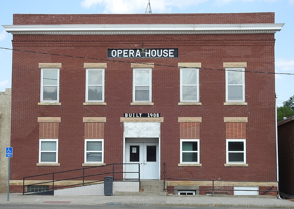
Built in 1909 (Neoclassical architecture). Listed on the National Register of Historic Places in 1987.
From the record
“The Selby Opera House, at 3409 Main St. in Selby, South Dakota is a Classical Revival building built in 1909. It was listed on the National Register of Historic Places in 1987.”
Wikipedia article Selby Opera House, CC BY-SA 4.0.
One of 10 National Register listings published here for Walworth County · listed in 1987 · category: Building · built in 1909, Neoclassical architecture.
National Register reference number.87001730- the number the National Park Service assigned this property when it was listed, and the key its nomination file is catalogued under at the National Archives.
Fires near this property
3 since 1999
Regional context, not property-specific
evidence. The
federal wildfire occurrence database
lists 3 fires within 5 miles of Selby Opera House
between 1999 and 2018, burning about 2 acres in total. 1 started naturally. None was recorded as arson.
Distance is straight-line from the map coordinates, so a fire counted
here may appear on a neighbouring settlement's page as well.
Reported cause
Fires
Missing data/not specified/undetermined
1
Debris and open burning
1
Natural
1
The most recent of
them, most recent first, with the day each was reported and the service
that recorded it.
Regional context, not property-specific
evidence. The federal mineral resources record lists
1 working within 5 miles of Selby Opera House: 1 past producer.
None of them still produces. What was taken out: Sand and Gravel, Construction. Distance is straight-line from the
map coordinates, so a quarry counted here may appear on a neighbouring
settlement's page as well.
Regional context, not property-specific
evidence. The National Weather Service names
Selby, the town this property stands in, in 55 storm reports between 1994 and 2025: 29 hail, 25 thunderstorm wind, 1 flash flood.
No death or injury is recorded in these reports. Each account below is quoted exactly as the forecast office
filed it, from the NOAA Storm Events Database, and each date
opens the federal record of that event.
Due to the very heavy rainfall earlier, the dam at Lake Hiddenwood broke in the early morning hours spreading water northwest through a creek. Several roads were flooded along with crop and pastureland. The earthen dam was built in 1927 and was 27 feet high with a concrete spillway. The bridge over the spillway was also destroyed. The lake was one of the first artificial lakes in South Dakota. Lake Hiddenwood State Park was closed indefinitely.
Eighty mph winds southwest of Selby destroyed a 60 by 120 foot pole barn and took off the top half of a silo. Two grain bins were also blown away along with several trees uprooted.
One-hundred mph winds downed six power poles and caused considerable damage to sunflowers, corn, wheat, and beans. Also, an empty grain bin was blown over and damaged. Numerous trees were snapped off.
One-hundred mph winds downed six power poles and caused considerable damage to sunflowers, corn, wheat, and beans. Also, an empty grain bin was blown over and damaged. Numerous trees were snapped off.
Tennis ball size hail along with high winds caused a lot of damage throughout Selby. Many east and north windows were broken along with many vehicle's windshields. Also, many vehicles were dented, house siding was damaged, gardens were completely destroyed, and many acres of crops around Selby were destroyed.
High winds destroyed a 160' by 50' machine shed causing some damage to a tractor loader. Boards went through the window of the garage with one going through the door. An empty grain bin was blown over onto a grain cart, both were damaged. The house and other buildings sustained some shingle damage. A pole barn was also blown apart.
No historic map-sheet match is published
for this property yet. That does not mean no map exists. This record needs
a coordinate-quality review before it can be joined to a sheet boundary.
Browse the county's mapped places while that work is
pending.
Listed places nearby
2 within 8 miles
Other National Register properties close
enough to walk or drive between, ordered by distance from this one. Both
positions come from the same geocoding pass that matched these properties
to their map sheets.
Listing record. National Park Service National Register of Historic Places, listed-properties dataset, current to 2026-05-22.
Map join. Address geocoded through the United States Census geocoder, then tested against the published boundary of every sheet in the USGS Historical Topographic Map Collection.
How this page is made. Listing fields come from federal records; map-sheet coverage is a labelled coordinate-to-boundary calculation, not a source-field claim.
Wildfire. Short, Karen C. 2022. Spatial wildfire occurrence data for the United States, 1992-2020 [FPA_FOD_20221014]. 6th Edition. Fort Collins, CO: Forest Service Research Data Archive. https://doi.org/10.2737/RDS-2013-0009.6 Collected with United States Government funding and usable without additional permissions or fees.
Mines and quarries. USGS Mineral Resources Data System (MRDS) https://mrdata.usgs.gov/mrds/ A work of the United States government, no copyright under 17 U.S.C. 105.
Storms. NOAA National Centers for Environmental Information, Storm Events Database https://www.ncei.noaa.gov/stormevents/ A work of the United States government, no copyright under 17 U.S.C. 105. Narratives are quoted verbatim from the National Weather Service report and are not edited or summarised.
 Block