 Block
From the record
1 National Register listing published here.
Sources: the National Register database, National Park Service
25 topographic sheets cover 10 settlements here, and 1 property is on the National Register of Historic Places.
1 National Register listing published here.
Sources: the National Register database, National Park Service
Every property in this county listed on the National Register of Historic Places, with the year it was listed and the federal nomination document.
| Photograph | Property | Type | Listed | Reference |
|---|---|---|---|---|
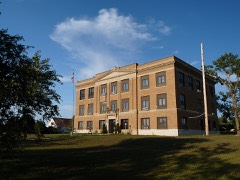 | Ziebach County Courthouse | building | 1993 | 92001864 |
Every wildfire the federal occurrence database records inside this county: 1,294 of them, burning about 43,437 acres. 395 started naturally and 44 were recorded as arson. Each settlement page carries the fires within five miles of it.
| Reported cause | Fires |
|---|---|
| Natural | 395 |
| Equipment and vehicle use | 227 |
| Missing data/not specified/undetermined | 169 |
| Debris and open burning | 139 |
| Misuse of fire by a minor | 138 |
| Fireworks | 89 |
| Arson/incendiarism | 44 |
| Power generation/transmission/distribution | 37 |
| Smoking | 20 |
| Recreation and ceremony | 20 |
| Other causes | 16 |
The five largest, by the area the report gives. None of them was recorded as arson.
| Date | Cause | Size | Reported by | Name on the report |
|---|---|---|---|---|
| 19 October 2000 | Equipment and vehicle use | 9,431 acres | Cheyenne River Agency | GENO H. |
| 17 September 2000 | Natural | 4,648 acres | Cheyenne River Agency | JENSEN |
| 23 August 2020 | Natural | 3,380 acres | Cheyenne River Agency | BENT RIM |
| 3 August 2006 | Natural | 2,330 acres | Cheyenne River Agency | BALL CREEK COMPLEX |
| 5 September 2000 | Natural | 1,102 acres | Cheyenne River Agency | JOHNSON |
| 11 November 1993 | Equipment and vehicle use | 1,089 acres | Cheyenne River Agency | FISHER |
| 5 September 2000 | Natural | 1,052 acres | Cheyenne River Agency | TAKINI#2 |
| 5 September 2000 | Natural | 817 acres | Cheyenne River Agency | BULLCREEK |
Every settlement page carries the fires within five miles of it - see the settlement index below.
The NOAA Storm Events Database holds 489 reports for this county, causing no deaths, 7 injuries and about $4,280,060 in recorded property damage. Each settlement page carries the reports that name it.
| Kind of event | Reports |
|---|---|
| Thunderstorm Wind | 222 |
| Hail | 200 |
| Flood | 27 |
| Tornado | 24 |
| Flash Flood | 13 |
| Funnel Cloud | 1 |
| Wildfire | 1 |
| Heavy Rain | 1 |
The most serious of them, by death, then injury, then recorded damage. The accounts are quoted exactly as the forecast office filed them.
| When | Event | Place named | Harm | What the report says |
|---|---|---|---|---|
| May 2015 | Thunderstorm Wind | Cherry Creek | 3 hurt, $5,000 | Gusty winds blew the community center's roof into the building. About 40 people were attending a meeting and three received minor injuries. |
| June 2010 | Tornado (EF2) | Dupree | 2 hurt, $750,000 | Another tornado touched down just south of Dupree and moved along the west side of town. It tore the roof off the community center, damaged a house and garage, crumpled large grain bins, and tossed several mobile homes. One person was injured when a mobile home was blown into the car in which he had taken cover and another person received minor injuries. |
| August 2016 | Thunderstorm Wind | Bridger | 2 hurt | A trailer house was blown over by thunderstorm winds, injuring two people inside. |
| May 2019 | Flash Flood | Red Elm | $750,000 | Three to five inches of rain fell in about two hours over portions of southern Ziebach County, causing rapid rises on small creeks and overland flooding of rural areas. Several county and BIA roads were washed out, including Dupree Road and BIA 9. US Highway 212 near mile marker 121 was also inundated. |
| August 2011 | Hail | Dupree | $500,000 | The combination of large hail and 50 mph wind gusts caused damage throughout town. |
| June 2008 | Flash Flood | Cherry Creek | $500,000 | Homes and roads were flooded around the community of Cherry Creek. |
| May 2019 | Flood | Red Scaffold | $300,000 | Runoff from heavy rain caused overland flooding and flooding along Cherry Creek, Red Scaffold Creek, and Bear Creek. Several roads were inundated, including Bear Creek Road and Cherry Creek Road. Releases from Angostura Dam, combined with runoff from heavy rain, caused major flooding along the Cheyenne River. The Cheyenne River near Plainview reached a preliminary height of 22.87 feet and a peak flow of 61,900 cfs on May 23, which is a new record height and the second highest discharge ever recorded at the location. |
| June 1983 | Tornado (F3) | not stated | $250,000 | no account filed |
| June 2014 | Flood | Red Scaffold | $200,000 | Flooding occurred along Bull Creek and Cherry Creek and its tributaries. Tankini and Red Scaffold Roads were flooded in a few locations. High water in Howes Grazing Lake and Lake Buffalo eroded the shoulder of SD Highway 34/73 between Bridger and Howes. The highway was closed for eight days while temporary repairs were made and both lakes were drained to more manageable levels. The highway was closed again in early August for five weeks so permanent repairs could be made. |
| June 2008 | Flood | Glad Valley | $200,000 | A portion of the community of Cherry Creek was inundated by flood waters. Major flooding was reported along Cherry Creek, the Moreau River, the Cheyenne River, and their tributaries. |
| June 2010 | Flash Flood | Iron Lightning | $150,000 | Four to seven inches of rain caused flash flooding in Dupree and along Bear Creek, Ash Creek, and the Moreau River. Several sections of U.S. Highway 212 were under water at least a foot deep and the highway was closed for several hours. Basements of several homes and buildings flooded. |
| June 2014 | Flood | Glad Valley | $100,000 | Hail and over four inches of rain fell in less than 24 hours over northern Ziebach County, with the runoff causing significant flooding. Over 140 roads and culverts were flooded or damaged, including the road near Glad Valley Dam. |
| May 2009 | Tornado (EF1) | Red Elm | $100,000 | A tornado touched down west of Dupree and tracked eastward before dissipating northeast of Dupree. It dented several grain bins, blew over a small mobile home and semi trailer truck, tore sheet metal off sheds, and toppled a large communications tower. |
| August 2011 | Thunderstorm Wind | Dupree | $50,000 | The combination of large hail and strong wind caused damage. |
| July 2008 | Thunderstorm Wind | Dupree | $50,000 | Large tree branches were blown down, windows were broken, and automobiles were damaged by the combination of large hail and strong wind gusts. |
| June 2012 | Hail | Glad Valley | $50,000 | no account filed |
| July 2000 | Thunderstorm Wind | Cherry Creek | $50,000 | no account filed |
| June 2012 | Thunderstorm Wind | Dupree | $30,000 | A barn was torn apart and the timber and tin siding were blown about a mile away. Another barn had damage to its rafters, walls, and doors. The house had minor damage and several trees and power lines were blown down. |
| October 2011 | Thunderstorm Wind | Glad Valley | $25,000 | Strong winds blew down tree branches as large as 12 inches in diameter and snapped power poles. |
| June 1962 | Tornado (F0) | not stated | $25,000 | no account filed |
| July 2013 | Thunderstorm Wind | Dupree | $20,000 | The combination of large hail and strong winds broke windows and tore siding off the north side of a house. |
| June 2005 | Hail | Red Scaffold | $20,000 | Hail damaged automobile and roof of house. |
| August 2004 | Hail | Red Scaffold | $20,000 | Calf shelters were blown away, windows were broken, and roof shingles were blown off. |
| July 2010 | Thunderstorm Wind | Dupree | $15,000 | Large wind-driven hail broke windows of homes and automobiles. |
| June 2012 | Thunderstorm Wind | Red Elm | $10,000 | The combination of hail and wind damaged a house and vehicles. |
| June 2010 | Tornado (EF1) | Red Elm | $10,000 | Another tornado touched down southwest of Dupree and crossed U.S. Highway 212. It blew down several power poles. A small satellite tornado was observed at 1730 MST. |
| July 2010 | Thunderstorm Wind | Glad Valley | $10,000 | Large hail and strong winds broke windows. |
| August 2013 | Hail | Dupree | $10,000 | no account filed |
| June 2012 | Hail | Iron Lightning | $10,000 | no account filed |
| June 2012 | Hail | Red Elm | $10,000 | no account filed |
| July 2010 | Hail | Glad Valley | $10,000 | no account filed |
| June 1996 | Hail | Dupree | $10,000 | no account filed |
| May 2013 | Flash Flood | Dupree | $5,000 | Over four inches of rain fell in two hours. Runoff washed gravel off several roads. |
| August 2013 | Thunderstorm Wind | Iron Lightning | $5,000 | A pole barn was lifted off its foundation by strong winds. |
| August 2013 | Thunderstorm Wind | Iron Lightning | $5,000 | The combination of wind and hail caused property damage. |
| August 2011 | Thunderstorm Wind | Red Elm | $5,000 | A spotter estimated wind gusts reached 80 mph. |
| June 2012 | Hail | Glad Valley | $5,000 | no account filed |
| June 2012 | Hail | Red Elm | $5,000 | no account filed |
| July 2005 | Hail | Cherry Creek | $5,000 | no account filed |
| August 2017 | Flash Flood | Red Scaffold | $2,000 | Three to five inches of rain fell during the morning across southern Ziebach County. Runoff from the heavy rain caused flash flooding along Ash and Rattlesnake Creeks. Water ran over county roads north of BIA 6 including BIA27/Ash Creek Road, and several stock ponds exceeded capacity. |
| July 2012 | Thunderstorm Wind | Red Elm | $2,000 | Large tree branches were downed by the wind and steel siding was ripped off a barn. |
| October 1997 | Hail | Dupree | $1,000 | Windows broken in vehicles. |
| June 1983 | Tornado (F0) | not stated | $30 | no account filed |
| July 1982 | Tornado (F0) | not stated | $30 | no account filed |
| April 2026 | Thunderstorm Wind | Bridger | - | SDOT submitted wind gust report. |
| June 2025 | Thunderstorm Wind | Thunder Butte | - | SD mesonet recorded wind gust. |
| July 2025 | Thunderstorm Wind | Thunder Butte | - | Chaser reported a tree uprooted. |
| July 2025 | Thunderstorm Wind | Thunder Butte | - | Snapped the trunk of a 30 ft tall Elm Tree that was about a foot in diameter. |
| July 2025 | Thunderstorm Wind | Thunder Butte | - | Chaser reported a snapped the trunk of a 30 ft tall Elm Tree that was about a foot in diameter. |
| July 2025 | Thunderstorm Wind | Bridger | - | SD Mesonet recorded wind gust. |
| September 2025 | Thunderstorm Wind | Bridger | - | SD Mesonet Station recorded the wind gust. |
| September 2025 | Thunderstorm Wind | Bridger | - | SD Mesonet Station recorded the wind gust. |
| September 2025 | Thunderstorm Wind | Bridger | - | SD Mesonet Station recorded the wind gust. |
| July 2024 | Thunderstorm Wind | Dupree | - | Roof partially blown off of a barn at the Dupree Rodeo Arena. Tree branches and a few power poles were downed in the area. |
| June 2024 | Thunderstorm Wind | Red Elm | - | The spotter estimated wind gusts at 60 mph. |
| June 2024 | Thunderstorm Wind | Dupree | - | Wind gusts were estimated at around 60 mph. |
| May 2023 | Flood | Cherry Creek | - | Minor flooding of agricultural land along the Cheyenne River occurred. The river gage crested at 22.65 feet on May 15 at 500 AM MDT. |
| June 2023 | Flash Flood | Red Elm | - | Four to six inches of rain fell in three hours between Red Elm and Dupree. The water quickly entered Bear Creek, which became about a quarter mile wide; inundating roads, fields, crops, and outbuildings. Water approached a residence near Red Elm and a home near Dupree. Water covered portions of 216th Avenue and 217th Avenue. |
| June 2023 | Flood | Red Elm | - | The flash flooding transitioned to flooding as high flows continued on Bear Creek after four to six inches of rain fell in three hours between Red Elm and Dupree. Bear Creek was reported to be a quarter mile wide in spots; which inundated roads, fields, crops, and outbuildings. Water approached a residence near Red Elm and a home near Dupree. Water covered portions of 216th Avenue and 217th Avenue. |
| May 2022 | Thunderstorm Wind | Thunder Butte | - | The combination of wind and hail broke windows in a home. |
The Survey's mineral resources record lists 1 working inside this county. It still produces. Each settlement page carries the workings within five miles of it.
| Commodity | Workings |
|---|---|
| Sand and Gravel, Construction | 1 |
The least common of them first, because a county's hundredth gravel pit says nothing its first ten did not.
| Where | Site | Commodity | Status | Recorded |
|---|---|---|---|---|
| Bill Scholl Pit | Sand and Gravel, Construction | Producer |
Named settlements recorded in the Geographic Names Information System, each with the topographic sheets covering it. Villages, hamlets and abandoned places alike. Each is shown with the nearest named watercourse or landform and the survey quadrangle it falls on.
North Ziebach unorganized territory · 57626 · On Flint Rock Creek · Red Elm NW quadrangle
7 sheets, 1951 to 1986
South Ziebach unorganized territory · 57623 · Diermier Ranch quadrangle
6 sheets, 1954 to 1986
South Ziebach unorganized territory · 57622 · On Cherry Creek · Cherry Creek quadrangle
8 sheets, 1954 to 1986
North Ziebach unorganized territory · 57644 · Glad Valley quadrangle
8 sheets, 1953 to 1998
North Ziebach unorganized territory · 57623 · On Knife Creek · Red Elm NE quadrangle
7 sheets, 1951 to 1986
South Ziebach unorganized territory · 57626 · On Red Scaffold Creek · Red Scaffold quadrangle
6 sheets, 1954 to 1986
North Ziebach unorganized territory · 57623 · On Thunder Butte Creek · Thunder Butte quadrangle
8 sheets, 1951 to 1986