 Block
From the record
One of 107 National Register listings published here for Minnehaha County · listed in 2000 · category: District.
Sources: the case file at the National Archives · the National Register database, National Park Service
Listed on the National Register of Historic Places in 2000.
One of 107 National Register listings published here for Minnehaha County · listed in 2000 · category: District.
Sources: the case file at the National Archives · the National Register database, National Park Service
The chapter on Garretson City in History of Minnehaha County, South Dakota. Containing an Account of Its Settlements, Growth, Development and Resources ... Synopsis of Public Records, Biographical Sketches .., published 1899 names Garretson. This is what it says, exactly as the scans read.
C. W. Locke was appointed city physician, and the Garretson Prog-ress was made the official newspaper; ordinance No. 1, was introduced, fixing- the salary of the city officials at one dollar each for mayor and aldermen, one hundred dollars for the auditor, and for the treasurer two per cent, of all moneys collected. At a meetingheld December 14, Charles O'Leary was appointed street commissioner.
Passage source: History of Minnehaha County, South Dakota. Containing an Account of Its Settlements, Growth, Development and Resources ... Synopsis of Public Records, Biographical Sketches .., published 1899.
The Garretson Progress. - This newspaper was established at the city of Garretson, and its first issue g-iven to the public on the 12th day of November, 1889. It was a weekly newspaper, Republican in politics, and edited and published by Frank Eastwood, wdio remained in charg-e about three years. For a few months in 1892, while the political campaig-n was in prog-ress, a Mr. Hunt was in charg-e of this paper, and if there are any persons who were at that time candidates for office in Minnehaha county who did not g-et acquainted with him and loan him a few dollars, they must have been unusually hard pressed financially, or had little confidence in their election. The writer is on the list, but felt comfortable upon compairing notes with other candidates and finding- what amount they had contributed to this newspaper enterprise. After the campaig-n was over he soug-ht a new field. Dean P. Buell succeeded Mr. Hunt, and the first issue of the paper under his manag-ement was on the 23d day of December, 1892. He remained in charg-e until February 17, 1893, when J, B. Morrison of Sioux Falls became the owner of the plant, and continued its publication until July, 1894, when it again came into the hands of Frank Eastwood. He chang-ed the name of the paper to that of the Minnehaha County Herald, and shortly after sold out to Messrs. Edmison and Jameson of Sioux Falls, who issued their first paper on the 24th day of Aug-ust, 1894. They published it until March, 1896, when they sold out to Henry A. Beards- ley, who chang^ed the name back to that of The (rarretson Progress. December 1, 1897, the Ward Brothers of Dell Rapids bout^ht the paper and H. W. Ward took editorial charg-e of the same and has since been its editor and publisher. During- its entire career it has 1)een chiefly devoted to local matters, and at times has been a <»'ood newspaper. The present editor is eneru-etically endeavor injjf to make it a good county paper, and it is pleasing- to the writer to be able to sav, that he is succeeding- in doing- so, and that the livelv little cit\' of (iarretson has a newspaper worthy of the ])atronage of her citizens.
Passage source: History of Minnehaha County, South Dakota. Containing an Account of Its Settlements, Growth, Development and Resources ... Synopsis of Public Records, Biographical Sketches .., published 1899.
Machine-read from a century-old scan, so expect the errors a machine makes: misspelled names, dropped words, stray characters.
Read the whole chapter on Garretson City - 38,671 words on its settlement, mills, schools and churches.
Regional context, not property-specific evidence. The federal wildfire occurrence database lists 21 fires within 5 miles of Split Rock Creek Park Historic District between 2009 and 2020, burning about 124 acres in total. None started naturally. None was recorded as arson. Distance is straight-line from the map coordinates, so a fire counted here may appear on a neighbouring settlement's page as well.
| Reported cause | Fires |
|---|---|
| Missing data/not specified/undetermined | 13 |
| Railroad operations and maintenance | 3 |
| Debris and open burning | 2 |
| Misuse of fire by a minor | 1 |
| Recreation and ceremony | 1 |
| Equipment and vehicle use | 1 |
The most recent of them, most recent first, with the day each was reported and the service that recorded it.
| Date | Cause | Size | Reported by | Name on the report |
|---|---|---|---|---|
| 26 September 2011 | Missing data/not specified/undetermined | under an acre | South Dakota Wildland Fire Suppression | STVAWTQ |
| 30 August 2020 | Equipment and vehicle use | under an acre | South Dakota Wildland Fire Suppression | INC NO 91 8/30/2020 |
| 19 August 2020 | Debris and open burning | under an acre | South Dakota Wildland Fire Suppression | INC NO 89 8/19/2020 |
| 25 June 2014 | Missing data/not specified/undetermined | 3.0 acres | South Dakota Wildland Fire Suppression | NORTH IGLOO FIRE |
| 15 June 2020 | Railroad operations and maintenance | under an acre | South Dakota Wildland Fire Suppression | INC. NO 68 6/15/2020 |
| 15 June 2019 | Railroad operations and maintenance | under an acre | South Dakota Wildland Fire Suppression | JUNE BNSF |
| 6 May 2019 | Missing data/not specified/undetermined | under an acre | South Dakota Wildland Fire Suppression | BOYD FIRE |
| 5 May 2015 | Railroad operations and maintenance | under an acre | South Dakota Wildland Fire Suppression | BNSF FIRE 5/5/2015 |
Regional context, not property-specific evidence. The federal mineral resources record lists 13 workings within 5 miles of Split Rock Creek Park Historic District: 8 unknowns, 4 past producers, 1 producer. 1 still produces. What was taken out: Sand and Gravel, Construction. Distance is straight-line from the map coordinates, so a quarry counted here may appear on a neighbouring settlement's page as well.
| Where | Site | Commodity | Status | Recorded |
|---|---|---|---|---|
| Arnold Gravel Pit | Sand and Gravel, Construction | Unknown | ||
| Duane Bly Pit | Sand and Gravel, Construction | Past Producer | ||
| Dubbelde Gravel Pit Nw | Sand and Gravel, Construction | Unknown | ||
| Dubbelde Gravel Pit Se | Sand and Gravel, Construction | Unknown | ||
| Harnack Sand Pit | Sand and Gravel, Construction | Unknown | ||
| Julson Gravel Pit | Sand and Gravel, Construction | Unknown | ||
| Limburger Gravel Pit | Sand and Gravel, Construction | Unknown | ||
| Pat Kinney Gravel Pit | Sand and Gravel, Construction | Unknown | ||
| Sherman Gravel Pit | Sand and Gravel, Construction | Producer | ||
| Ulvio Gravel Pit | Sand and Gravel, Construction | Unknown |
Regional context, not property-specific evidence. The National Weather Service names Garretson, the town this property stands in, in 47 storm reports between 1997 and 2024: 22 hail, 13 thunderstorm wind, 9 flood, 1 tornado. No death or injury is recorded in these reports. Each account below is quoted exactly as the forecast office filed it, from the NOAA Storm Events Database, and each date opens the federal record of that event.
| When | Event | Place named | Harm | What the report says |
|---|---|---|---|---|
| June 2015 | Thunderstorm Wind | Garretson | $1,500,000 | Thunderstorm winds estimated at 100 mph caused widespread damage to trees and power lines and damaged several homes. Many trees were blown over or completely uprooted. At least one house was completely destroyed, and others had parts of their roofs blown off. Windows were broken and a large camper was rolled several times and torn apart. Other vehicles were damaged, some severely by garage debris or falling trees. Grandstands at a baseball field were damaged. At least one barn and several silos and smaller structures at area farms were destroyed. The elevator in town was severely damaged. No injuries were reported. |
| August 2004 | Thunderstorm Wind | Garretson | $1,000,000 | Thunderstorm winds severely damaged a large metal framed storage building, destroyed a 50 thousand bushel grain elevator, and destroyed the press box at a football field. the winds also severely damaged a large recreational building, blew down road signs, and damaged siding and roofs. Holes were left in several homes and city buildings. A brick wall of the old part of the Garretson School was damaged along its length. The winds caused widespread tree damage. Tree debris blocked most roads in Garretson. Power lines and poles were blown down, resulting in power outages which affected both the town and nearby rural areas. Several vehicles were damaged by flying or falling debris. The winds caused widespread crop damage in the area, but the amount of crop damage could not be determined. |
| September 2019 | Flood | Garretson | $100,000 | After excessive two-day rainfall during September 10-12 (record 2-day rainfall of 6.75 inches at Pipestone, 4.37 inches near Garretson), Split Rock Creek near Corson (gage site COSS2) reached the highest stage on record of 10.20 feet above flood stage on September 12. Flood waters completely inundated the Brandon golf course, with State Highway 11 closed in multiple locations. Numerous homes were inundated by water.||Numerous county roads were under water near Sherman, including 250th Street. |
| May 2007 | Thunderstorm Wind | Garretson | $50,000 | Thunderstorm winds heavily damaged two buildings at an auotmobile recycling business, damaged inventory inside one of the buildings, caused tree damage including a few trees blown down, and damaged the porch of a farmhouse. |
| July 2022 | Flash Flood | Garretson | $20,000 | Several vehicles were flooded near the high school in water which reached a depth of 2 to 3 feet. |
| August 2010 | Thunderstorm Wind | Garretson | $5,000 | Thunderstorm winds blew the roof off a barn. |
| May 2024 | Thunderstorm Wind | Garretson | - | A hoop house was blown over and multiple large branches were taken down by thunderstorm winds. |
| June 2024 | Flood | Garretson | - | Split Rock Creek near Corson rose above flood stage the morning of June 21st, cresting around 7.59 feet above flood stage (16.09 feet) on June 22nd. This crest is in the Major Stage. The creek then fell below flood stage on the afternoon of June 25th. For a more comprehensive description of flood damage, please see other entries for Minnehaha County. |
| April 2023 | Flood | Garretson | - | Split Rock Creek near Corson, SD rose above flood stage on the evening of April 9th before cresting around 1.74 feet above flood stage (10.24 feet) on April 9th. The creek then fell below flood stage on the morning of April 10th. |
| July 2022 | Flood | Garretson | - | Heavy rainfall from 3 to 5 inches fell between Garretson and Brandon in the Split Rock Creek Basin. Rapid runoff resulted in brief minor flooding from late on July 5 through early July 6, as Split Rock Creek near Corson (gage site COSS2) crested 1.49 feet above flood stage at 2300CST July 5. A significant amount of low-lying rural land was flooded. |
| March 2019 | Flood | Garretson | - | Snow melt and heavy rainfall (measured 3.07 inches 14 miles north northeast of Sioux Falls and 2.11 inches near Garretson) resulted in significant flooding of agricultural lands. State Highway 11 was barricaded due to water over the road near the confluence with Beaver Creek. Split Rock Creek at Corson (gage site COSS2) reached the tenth highest stage on record cresting 4.42 feet above flood stage on March 14. |
| April 2019 | Flood | Garretson | - | A surge in runoff following a major early spring storm produced another period of flooding for agricultural land between Garretson and the confluence with the Big Sioux River south of Brandon. Split Rock Creek near Corson (gage site COSS2) crested at 0.17 feet above flood stage on April 16. |
| April 2019 | Flood | Garretson | - | Runoff from occasional precipitation in late March and early April produced considerable flooding of agricultural land. Water inundated the garden center near the confluence with the Big Sioux River south of Brandon. Split Rock Creek near Corson (gage site COSS2) crested in moderate flood stage (2.68 feet above flood stage) on April 7. |
| September 2018 | Flood | Garretson | - | With areas north of Sioux Falls just on the northern edge of heaviest rainfall from September 18-20, amounts generally 4 to 7 inches resulted in moderate flooding of agricultural land. Split Rock Creek near Corson (gage site COSS2) crested 3.7 feet above flood stage on September 21, and dropped below flood stage on September 23. |
| June 2018 | Flood | Garretson | - | A week of periodic heavy rainfall ending June 26 resulted in a widespread 4 to 8 inches of rainfall, much of which occurred on June 20, 24 and 25. Specific weekly totals included 4.02 inches at Pipestone, 2.14 inches near Edgerton, 7.48 inches at EROS Data Center and several reports around 8 inches near Garretson. Moderate flooding occurred with significant amounts of crop and pasture land inundated along with a garden center near the confluence with the Big Sioux River as Split Rock Creek at Corson (gage site COSS2) crested 4.3 feet above flood stage on June 21. The river dropped below flood stage on June 22, but returned above flood stage and crested again at moderate flood stage 3.9 feet above flood stage on June 26. The river fell below flood stage on June 28. |
| August 2017 | Funnel Cloud | Garretson | - | Social Media report. |
| July 2011 | Thunderstorm Wind | Garretson | - | Thunderstorm winds caused tree damage, including up to 3 inch diameter branches blown down. The winds were accompanied by large hail and heavy rain. |
| August 2010 | Thunderstorm Wind | Garretson | - | Thunderstorm winds caused tree damage, including several branches blown down. |
| July 2009 | Thunderstorm Wind | Garretson | - | Thunderstorm winds caused an unknown amount of tree damage. |
| June 2005 | Thunderstorm Wind | Garretson | - | Thunderstorm winds damaged trees and power lines. |
| August 2004 | Thunderstorm Wind | Garretson | - | Thunderstorm winds damaged trees and power lines, resulting in power outages. |
| June 2001 | Tornado (F0) | Garretson | - | A brief tornado caused no reported damage or injuries. |
| July 2023 | Hail | Garretson | - | no account filed |
| July 2023 | Hail | Garretson | - | no account filed |
| May 2022 | Hail | Garretson | - | no account filed |
| June 2014 | Hail | Garretson | - | no account filed |
| July 2011 | Hail | Garretson | - | no account filed |
| July 2011 | Hail | Garretson | - | no account filed |
| June 2005 | Hail | Garretson | - | no account filed |
| November 2005 | Hail | Garretson | - | no account filed |
| July 2004 | Hail | Garretson | - | no account filed |
| July 2004 | Hail | Garretson | - | no account filed |
| June 2003 | Hail | Garretson | - | no account filed |
| June 2003 | Thunderstorm Wind | Garretson | - | no account filed |
| May 2002 | Hail | Garretson | - | no account filed |
| May 2002 | Hail | Garretson | - | no account filed |
| May 2002 | Hail | Garretson | - | no account filed |
| June 2001 | Thunderstorm Wind | Garretson | - | no account filed |
| June 2001 | Hail | Garretson | - | no account filed |
| June 2001 | Hail | Garretson | - | no account filed |
| June 2001 | Hail | Garretson | - | no account filed |
| June 2001 | Thunderstorm Wind | Garretson | - | no account filed |
| June 2001 | Hail | Garretson | - | no account filed |
| June 2001 | Hail | Garretson | - | no account filed |
| May 2000 | Hail | Garretson | - | no account filed |
| July 2000 | Hail | Garretson | - | no account filed |
| May 1997 | Hail | Garretson | - | no account filed |
No historic map-sheet match is published for this property yet. That does not mean no map exists. This record needs a coordinate-quality review before it can be joined to a sheet boundary. Browse the county's mapped places while that work is pending.
Other National Register properties close enough to walk or drive between, ordered by distance from this one. Both positions come from the same geocoding pass that matched these properties to their map sheets.
| Photograph | Property | Distance | Listed |
|---|---|---|---|
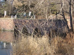 | Split Rock Park Bridge | 0.1 miles | 1993 |
| First National Bank of Garretson | 0.2 miles | 2011 | |
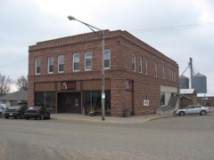 | Building at 529 North Main | 0.2 miles | 2005 |
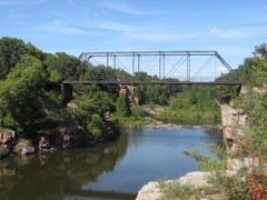 | Palisades Bridge | 2.3 miles | 1999 |
| Berg and Estensen Store | 2.9 miles | 2001 | |
| Slip Up Creek Homestead | 7.6 miles | 2003 |
| National Archives record | The nomination case file for reference 00000827 in Record Group 79. |
| Minnehaha County | All 107 listed properties in this county. |