 Block
From the record
One of 40 National Register listings published here for Bon Homme County · listed in 2003 · category: Building · built in 1900.
Sources: the case file at the National Archives · the National Register database, National Park Service
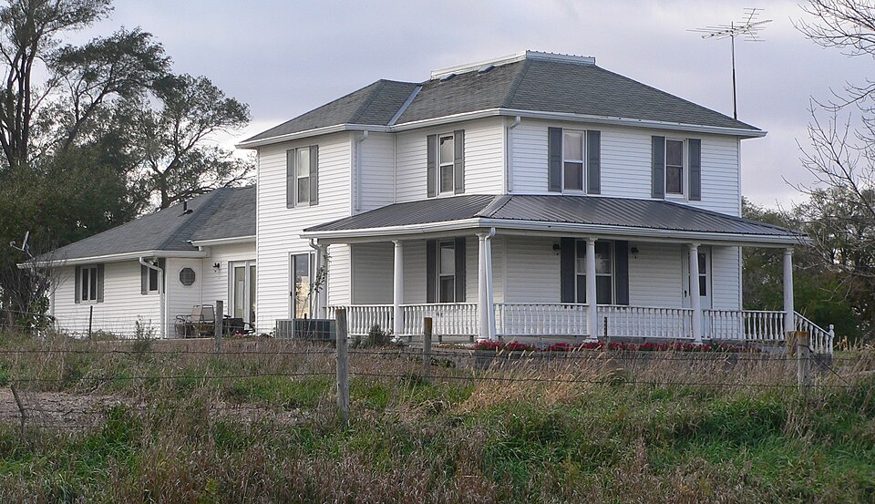
Built in 1900. Listed on the National Register of Historic Places in 2003.
One of 40 National Register listings published here for Bon Homme County · listed in 2003 · category: Building · built in 1900.
Sources: the case file at the National Archives · the National Register database, National Park Service
Regional context, not property-specific evidence. The federal wildfire occurrence database lists 11 fires within 5 miles of Thompson House between 2000 and 2020, burning about 10 acres in total. 1 started naturally. None was recorded as arson. Distance is straight-line from the map coordinates, so a fire counted here may appear on a neighbouring settlement's page as well.
| Reported cause | Fires |
|---|---|
| Missing data/not specified/undetermined | 4 |
| Debris and open burning | 3 |
| Fireworks | 2 |
| Natural | 1 |
| Equipment and vehicle use | 1 |
The most recent of them, most recent first, with the day each was reported and the service that recorded it.
| Date | Cause | Size | Reported by | Name on the report |
|---|---|---|---|---|
| 5 August 2015 | Natural | under an acre | South Dakota Wildland Fire Suppression | SMOKING BIRD FIRE |
| 22 August 2012 | Missing data/not specified/undetermined | 2.0 acres | South Dakota Wildland Fire Suppression | KREBER |
| 4 July 2000 | Fireworks | 1.1 acres | Springfield Volunteer Fire Department | FIREWORK |
| 9 May 2010 | Missing data/not specified/undetermined | 1.0 acres | South Dakota Wildland Fire Suppression | DVORACEK |
| 7 April 2020 | Fireworks | under an acre | Winnebago Agency | BOAT RAMP |
| 7 April 2020 | Debris and open burning | 1.0 acres | South Dakota Wildland Fire Suppression | HOVORKA |
| 6 April 2011 | Missing data/not specified/undetermined | 1.0 acres | South Dakota Wildland Fire Suppression | WALKER |
| 10 April 2020 | Debris and open burning | 1.0 acres | South Dakota Wildland Fire Suppression | TORSNEY |
Regional context, not property-specific evidence. The federal mineral resources record lists 6 workings within 5 miles of Thompson House: 6 past producers. None of them still produces. What was taken out: Sand and Gravel, Construction. Distance is straight-line from the map coordinates, so a quarry counted here may appear on a neighbouring settlement's page as well.
| Where | Site | Commodity | Status | Recorded |
|---|---|---|---|---|
| Dewey Thompson Gravel Pit | Sand and Gravel, Construction | Past Producer | ||
| Gravel Pit | Sand and Gravel, Construction | Past Producer | ||
| Gravel Pit | Sand and Gravel, Construction | Past Producer | ||
| Gravel Pit | Sand and Gravel, Construction | Past Producer | ||
| Henry Frick Gravel Pit | Sand and Gravel, Construction | Past Producer | ||
| James Kocer Gravel Pit | Sand and Gravel, Construction | Past Producer |
Regional context, not property-specific evidence. The National Weather Service names Springfield, the town this property stands in, in 62 storm reports between 1993 and 2024: 33 hail, 18 thunderstorm wind, 6 flood, 2 tornado. No death or injury is recorded in these reports. Each account below is quoted exactly as the forecast office filed it, from the NOAA Storm Events Database, and each date opens the federal record of that event.
| When | Event | Place named | Harm | What the report says |
|---|---|---|---|---|
| September 2016 | Thunderstorm Wind | Springfield | $1,000,000 | Thunderstorm winds destroyed about 6 houses, severely damaged several other houses and shops, destroyed or damaged several unattached garages, destroyed farm outbuildings and other farm structures, caused widespread tree damage, including numerous trees blown down, moved a large boat 25 yards from a parked position, damaging the boat, and damaged or destroyed outdoor furniture. |
| June 2006 | Thunderstorm Wind | Springfield | $100,000 | Thunderstorm winds caused widespread tree damage. Several trees and large branches were blown down. Some of the falling trees and branches damages homes and vehicles, including the roof of one house and one pickup truck which were heavily damaged. The wind blew down numerous power poles and power lines, causing a power outage in most of Springfield which lasted several hours. |
| June 2003 | Thunderstorm Wind | Springfield | $100,000 | Thunderstorm winds caused tree damage, including numerous trees and large limbs down. Several houses and vehicles were damaged by falling trees or tree debris. |
| July 2001 | Thunderstorm Wind | Springfield | $100,000 | Thunderstorm winds caused widespread tree damage. including some large trees blown down. Some falling trees damaged houses, especially roofs, with at least one chimney broken off. Several vehicles were also damaged. |
| June 2005 | Flash Flood | Springfield | $50,000 | Heavy rainfall of 4 to 6 inches caused flooding of numerous city streets, other roads, and basements. Several roads were partially washed out. |
| June 2003 | Hail | Springfield | $50,000 | Large hail damaged vehicles and cracked windows. Crop damage was suspected in the area but no damage estimates were available. |
| August 1996 | Thunderstorm Wind | Springfield | $50,000 | no account filed |
| May 2007 | Thunderstorm Wind | Springfield | $10,000 | Thunderstorm winds uprooted trees, caused additional tree damage, tipped over small sheds, and caused minor roof damage. |
| August 1996 | Lightning | Springfield | $10,000 | no account filed |
| July 1994 | Thunderstorm Wind | Springfield | $5,000 | Strong winds blew down or damaged several large trees and also blew down booths that were used for a July 4th celebration. |
| August 1993 | Thunderstorm Wind | Springfield | $5,000 | Strong thunderstorm winds resulted in some blown-out windows, downed antennas, and broken trees and branches on the north side of Springfield. |
| July 2024 | Thunderstorm Wind | Springfield | - | Considerable tree damage was reported in Springfield due to thunderstorm winds. |
| March 2023 | Hail | Springfield | - | Ping pong size hail was reported in Springfield, SD. |
| June 2023 | Thunderstorm Wind | Springfield | - | Thunderstorm wind gusts up to 64 mph were measured at a personal weather station in Springfield. |
| May 2023 | Thunderstorm Wind | Springfield | - | A flag pole was snapped off by thunderstorm winds, which also broke off several medium-sized branches in the yard. |
| May 2022 | Thunderstorm Wind | Springfield | - | Two foot diameter limbs were broken off numerous trees by thunderstorm wind gusts. |
| July 2022 | Thunderstorm Wind | Springfield | - | An extended period of thunderstorm wind gusts of 58 mph or greater was measured by personal weather station KSDSPRIN9 at Springfield. A peak wind gust of 77 mph occurred at 1404CST. |
| August 2021 | Hail | Springfield | - | Dime size hail was reported with occasional ping-pong size hail. Crop damage is an estimate from insured losses. Information provided by the United States Department of Agriculture. |
| July 2020 | Hail | Springfield | - | Pictures submitted showed hail slightly larger than 2 inches in diameter. |
| August 2019 | Thunderstorm Wind | Springfield | - | Numerous trees across town were damaged by strong thunderstorm winds, with several older trees toppled. |
| March 2019 | Flood | Springfield | - | Heavy rainfall (2.60 inches 8 miles west northwest of Springfield and 2.71 inches at Tyndall) and snow melt was the primary contributor to the flooding along Lewis and Clark Reservoir; however, the final level of crest had at least a partial contribution from an uncontrolled release with the failure of Spencer Dam along the Niobrara River in Nebraska during the evening of March 13. The highest crest on record resulted, as the Missouri River at Gavins Point Dam (gage site GPDN1) crested 2.02 feet above flood stage on March 15. |
| September 2015 | Hail | Springfield | - | Hail covered the ground. |
| September 2015 | Hail | Springfield | - | Large hail caused minor vehicle damage. |
| June 2014 | Hail | Springfield | - | Large hail damaged a corn crop by splitting leaves. The amount of crop damage was not known. |
| April 2012 | Tornado (EF0) | Springfield | - | A brief rope tornado caused no reported damage as it crossed over the northern edge of the Missouri River. |
| May 2011 | Hail | Springfield | - | Large hail caused an unknown amount of vehicle and window damage. |
| September 2010 | Flood | Springfield | - | Continued runoff from summer heavy rains helped continue flooding along the Missouri River. |
| October 2010 | Flood | Springfield | - | Minor to moderate flooding caused by runoff from summer heavy rains very slowly abated during the month, with a few roads along the river still flooded. |
| July 2010 | Flood | Springfield | - | Runoff from continued heavy rain helped continue minor flooding along the Missouri River. |
| June 2010 | Flood | Springfield | - | Runoff from heavy rain caused minor flooding of the Missouri River where it flows along Bon Homme County. Lowland flooding affected some campgrounds and other recreational areas. |
| August 2010 | Flood | Springfield | - | Runoff from heavy rain during the summer helped continue minor flooding along the Missouri River. |
| June 2009 | Thunderstorm Wind | Springfield | - | Thunderstorm winds blew down several branches. |
| June 2008 | Flash Flood | Springfield | - | Heavy rain caused flash flooding of roads and fields. Roads were closed in the town of Springfield due to the flooding. |
| August 2007 | Thunderstorm Wind | Springfield | - | Thunderstorm winds caused tree damage, including up to 8 inch diameter limbs blown down. |
| June 2005 | Hail | Springfield | - | Large hail, driven by 50 mph winds, caused crop damage. The amount of crop damage was not known. |
| July 2001 | Thunderstorm Wind | Springfield | - | Thunderstorm winds caused tree damage. The amount of damage was not known. |
| August 2000 | Hail | Springfield | - | Large hail covered the ground. |
| May 2023 | Hail | Springfield | - | no account filed |
| July 2020 | Hail | Springfield | - | no account filed |
| August 2019 | Hail | Springfield | - | no account filed |
| September 2015 | Hail | Springfield | - | no account filed |
| June 2013 | Hail | Springfield | - | no account filed |
| August 2011 | Hail | Springfield | - | no account filed |
| May 2008 | Hail | Springfield | - | no account filed |
| June 2008 | Hail | Springfield | - | no account filed |
| September 2007 | Hail | Springfield | - | no account filed |
| June 2005 | Hail | Springfield | - | no account filed |
| July 2003 | Hail | Springfield | - | no account filed |
| June 2003 | Hail | Springfield | - | no account filed |
| June 2003 | Hail | Springfield | - | no account filed |
| June 2002 | Hail | Springfield | - | no account filed |
| June 2002 | Hail | Springfield | - | no account filed |
| June 2002 | Hail | Springfield | - | no account filed |
| June 2002 | Hail | Springfield | - | no account filed |
| June 2002 | Hail | Springfield | - | no account filed |
| June 2002 | Hail | Springfield | - | no account filed |
| June 2002 | Hail | Springfield | - | no account filed |
| June 2002 | Hail | Springfield | - | no account filed |
| August 2000 | Thunderstorm Wind | Springfield | - | no account filed |
| May 1999 | Tornado (F0) | Springfield | - | no account filed |
No historic map-sheet match is published for this property yet. That does not mean no map exists. This record needs a coordinate-quality review before it can be joined to a sheet boundary. Browse the county's mapped places while that work is pending.
Other National Register properties close enough to walk or drive between, ordered by distance from this one. Both positions come from the same geocoding pass that matched these properties to their map sheets.
| Photograph | Property | Distance | Listed |
|---|---|---|---|
| Bon Homme Hutterite Colony | 4.1 miles | 1982 | |
| Jacob Sedlacek Chalkrock House | 5.0 miles | 1987 | |
| John Hakl Chalkrock House | 5.1 miles | 1987 | |
| John Travnicek Chalkrock House | 5.5 miles | 1987 | |
| Joseph Herman Chalkrock House | 5.6 miles | 1987 | |
| Joseph Herman Log Stable | 5.6 miles | 1987 |
| National Archives record | The nomination case file for reference 03001076 in Record Group 79. |
| Bon Homme County | All 40 listed properties in this county. |