 Block
From the record
One of 78 National Register listings published here for Yankton County · listed in 2004 · category: Building · built in 1914.
Sources: the case file at the National Archives · the National Register database, National Park Service
Built in 1914. Listed on the National Register of Historic Places in 2004.
One of 78 National Register listings published here for Yankton County · listed in 2004 · category: Building · built in 1914.
Sources: the case file at the National Archives · the National Register database, National Park Service
Regional context, not property-specific evidence. The federal wildfire occurrence database lists 51 fires within 5 miles of New Hope Farm Swine Barn between 1999 and 2019, burning about 343 acres in total. None started naturally. None was recorded as arson. Distance is straight-line from the map coordinates, so a fire counted here may appear on a neighbouring settlement's page as well.
| Reported cause | Fires |
|---|---|
| Missing data/not specified/undetermined | 24 |
| Debris and open burning | 15 |
| Smoking | 5 |
| Equipment and vehicle use | 3 |
| Power generation/transmission/distribution | 2 |
| Fireworks | 1 |
| Misuse of fire by a minor | 1 |
The most recent of them, most recent first, with the day each was reported and the service that recorded it.
| Date | Cause | Size | Reported by | Name on the report |
|---|---|---|---|---|
| 5 August 2012 | Missing data/not specified/undetermined | 4.0 acres | South Dakota Wildland Fire Suppression | MOOSE FIRE |
| 4 August 2012 | Missing data/not specified/undetermined | under an acre | South Dakota Wildland Fire Suppression | TURMAN FIRE |
| 1 August 2012 | Smoking | 1.0 acres | South Dakota Wildland Fire Suppression | STATE 50 FIRE |
| 26 July 2012 | Missing data/not specified/undetermined | 1.0 acres | South Dakota Wildland Fire Suppression | STATE 50 3 |
| 26 July 2012 | Missing data/not specified/undetermined | 1.0 acres | South Dakota Wildland Fire Suppression | STATE 50 2 |
| 24 July 2012 | Missing data/not specified/undetermined | 1.0 acres | South Dakota Wildland Fire Suppression | STATE 50 1 |
| 17 July 2012 | Missing data/not specified/undetermined | 1.0 acres | South Dakota Wildland Fire Suppression | TRAIL FIRE |
| 15 July 2018 | Missing data/not specified/undetermined | under an acre | South Dakota Wildland Fire Suppression | HWY 50 GRASS FIRE IN DITCH |
Regional context, not property-specific evidence. The federal mineral resources record lists 13 workings within 5 miles of New Hope Farm Swine Barn: 9 past producers, 4 producers. 4 still produce. What was taken out: Sand and Gravel, Construction. Distance is straight-line from the map coordinates, so a quarry counted here may appear on a neighbouring settlement's page as well.
| Where | Site | Commodity | Status | Recorded |
|---|---|---|---|---|
| Bohlmann Gravel Pit | Sand and Gravel, Construction | Producer | ||
| Gravel Pit | Sand and Gravel, Construction | Past Producer | ||
| Gravel Pit | Sand and Gravel, Construction | Past Producer | ||
| Gravel Pit | Sand and Gravel, Construction | Past Producer | ||
| Gravel Pit | Sand and Gravel, Construction | Past Producer | ||
| Gravel Pit | Sand and Gravel, Construction | Past Producer | ||
| Gravel Pit | Sand and Gravel, Construction | Past Producer | ||
| Gravel Pit | Sand and Gravel, Construction | Past Producer | ||
| Gravel Pit | Sand and Gravel, Construction | Past Producer | ||
| Old Allen Pit | Sand and Gravel, Construction | Past Producer |
Regional context, not property-specific evidence. The National Weather Service names Mission Hill, the town this property stands in, in 20 storm reports between 1996 and 2023: 11 hail, 8 thunderstorm wind, 1 tornado. No death or injury is recorded in these reports. Each account below is quoted exactly as the forecast office filed it, from the NOAA Storm Events Database, and each date opens the federal record of that event.
| When | Event | Place named | Harm | What the report says |
|---|---|---|---|---|
| June 2010 | Thunderstorm Wind | Mission Hill | $100,000 | Thunderstorm winds destroyed several large grain bins, blew down power lines and poles, and caused widespread tree damage, including several large trees blown down. |
| August 2000 | Thunderstorm Wind | Mission Hill | $70,000 | Thunderstorm winds damaged three mobile homes, and also damaged trees and power lines. |
| July 2020 | Thunderstorm Wind | Mission Hill | $30,000 | While dime size hail and winds to around 60 mph occurred in Mission Hill, it was part of a 3 mile wide swath of more significant wind-driven hail from around 4 miles north northwest of Mission Hill to a mile south of Mission Hill. Corn and soybean fields were pulverized to stubble, with most trees stripped of leaves. At a farm 3 miles northwest of Mission Hill, a grain bin, machine shed and trailer home each lost part of the roof. Along the path, three center irrigation pivots were overturned. Property damage costs are rough estimates. Crop damage is an estimate from insured losses. Information provided by the United States Department of Agriculture. |
| May 2008 | Thunderstorm Wind | Mission Hill | $5,000 | Thunderstorm winds damaged a garage. |
| June 2023 | Thunderstorm Wind | Mission Hill | - | Thunderstorm wind gusts downed a large tree limb. |
| May 2022 | Thunderstorm Wind | Mission Hill | - | Several tree limbs were snapped by thunderstorm winds. |
| May 2022 | Thunderstorm Wind | Mission Hill | - | A wall was blown out of a farm outbuilding. |
| April 2017 | Hail | Mission Hill | - | Hail was brief in nature and occurred with very heavy rain. |
| September 2014 | Thunderstorm Wind | Mission Hill | - | Thunderstorm winds caused tree damage, including several branches blown down. |
| September 2010 | Hail | Mission Hill | - | Large hails covered the ground. |
| June 2009 | Tornado (EF0) | Mission Hill | - | A brief tornado caused no reported damage. |
| April 2022 | Hail | Mission Hill | - | no account filed |
| September 2015 | Hail | Mission Hill | - | no account filed |
| August 2011 | Hail | Mission Hill | - | no account filed |
| July 2009 | Hail | Mission Hill | - | no account filed |
| May 2008 | Hail | Mission Hill | - | no account filed |
| June 2002 | Hail | Mission Hill | - | no account filed |
| June 2000 | Hail | Mission Hill | - | no account filed |
| June 2000 | Hail | Mission Hill | - | no account filed |
| June 1996 | Hail | Mission Hill | - | no account filed |
No historic map-sheet match is published for this property yet. That does not mean no map exists. This record needs a coordinate-quality review before it can be joined to a sheet boundary. Browse the county's mapped places while that work is pending.
Other National Register properties close enough to walk or drive between, ordered by distance from this one. Both positions come from the same geocoding pass that matched these properties to their map sheets.
| Photograph | Property | Distance | Listed |
|---|---|---|---|
| Lewis Olson Log House | 0.7 miles | 1980 | |
| New Hope Farm Polygonal Barn | 1.9 miles | 2004 | |
| Larson-Simonson House | 2.3 miles | 1980 | |
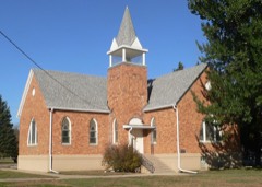 | United Church of Christ | 2.4 miles | 1980 |
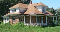 | Van Osdel House | 2.4 miles | 1980 |
| Bernt Gustad House | 2.6 miles | 1980 |
| National Archives record | The nomination case file for reference 03001538 in Record Group 79. |
| Yankton County | All 78 listed properties in this county. |