 Block
From the record
One of 27 National Register listings published here for Meade County · listed in 1973 · category: District.
Sources: the case file at the National Archives · the National Register database, National Park Service
Listed on the National Register of Historic Places in 1973.
One of 27 National Register listings published here for Meade County · listed in 1973 · category: District.
Sources: the case file at the National Archives · the National Register database, National Park Service
Regional context, not property-specific evidence. The federal wildfire occurrence database lists 122 fires within 5 miles of Fort Meade District between 1992 and 2020, burning about 3,996 acres in total. 33 started naturally. 2 were recorded as arson. Distance is straight-line from the map coordinates, so a fire counted here may appear on a neighbouring settlement's page as well.
| Reported cause | Fires |
|---|---|
| Natural | 33 |
| Debris and open burning | 30 |
| Missing data/not specified/undetermined | 16 |
| Railroad operations and maintenance | 10 |
| Recreation and ceremony | 8 |
| Equipment and vehicle use | 8 |
| Fireworks | 6 |
| Misuse of fire by a minor | 4 |
| Arson/incendiarism | 2 |
| Smoking | 2 |
| Other causes | 2 |
| Power generation/transmission/distribution | 1 |
The most recent of them, most recent first, with the day each was reported and the service that recorded it.
| Date | Cause | Size | Reported by | Name on the report |
|---|---|---|---|---|
| 8 September 2012 | Equipment and vehicle use | under an acre | South Dakota Wildland Fire Suppression | REDWATER HILL |
| 28 September 1998 | Debris and open burning | 25 acres | South Dakota Wildland Fire Suppression | SLY (NC) |
| 25 September 1999 | Misuse of fire by a minor | 1.0 acres | Sturgis Volunteer Fire Department | BLUCKSBURG |
| 15 September 2000 | Power generation/transmission/distribution | under an acre | Sturgis Volunteer Fire Department | PLEASANT VALLEY |
| 13 September 2005 | Natural | under an acre | Black Hills National Forest | VANOCKER |
| 9 August 2003 | Natural | under an acre | Montana/Dakotas State Office | SWIMMINGPO |
| 8 August 2016 | Natural | under an acre | South Dakota Wildland Fire Suppression | BEAR BUTTE |
| 7 August 2020 | Recreation and ceremony | under an acre | South Dakota Wildland Fire Suppression | POWERLINE |
Regional context, not property-specific evidence. The federal mineral resources record lists 2 workings within 5 miles of Fort Meade District: 1 past producer, 1 producer. 1 still produces. What was taken out: Niobium (Columbium), Tantalum, Sand and Gravel, Construction. Distance is straight-line from the map coordinates, so a quarry counted here may appear on a neighbouring settlement's page as well.
Regional context, not property-specific evidence. The National Weather Service names Sturgis, the town this property stands in, in 138 storm reports between 1993 and 2024: 91 hail, 34 thunderstorm wind, 5 flash flood, 5 flood. The reports record 5 injuries. Each account below is quoted exactly as the forecast office filed it, from the NOAA Storm Events Database, and each date opens the federal record of that event.
| When | Event | Place named | Harm | What the report says |
|---|---|---|---|---|
| August 2008 | Lightning | Sturgis | 3 hurt | Three people were injured by lightning at the Glencoe Camp Resort ticket booth. |
| August 2000 | Thunderstorm Wind | Sturgis | 2 hurt, $500,000 | no account filed |
| May 2019 | Flash Flood | Sturgis | $800,000 | Heavy rain and hail caused flooding in the Sturgis area. Several road crossings across Bear Butte Creek and Deadman Gulch were inundated; including 7th Street, 9th Street, 15th Street, Raccoon Road, and Sly Street. |
| July 2019 | Flash Flood | Sturgis | $639,000 | Extensive flooding occurred along Bear Butte Creek in Boulder Canyon through Sturgis to Fort Meade. Highway 34 was covered with water at the S-curve between Sturgis and Fort Meade, the Sturgis city park was completely underwater, and the 7th Street bridge at Bear Butte Creek was inundated. The Sly Street crossing, West Woodland Drive, and Blanche Street were damaged, as well as almost all the other crossings over Bear Butte Creek in Sturgis. |
| May 2019 | Flash Flood | Sturgis | $300,000 | Runoff from heavy rain on saturated ground caused flash flooding in the Sturgis, Fort Meade, and Pleasant Valley areas for the second time in a week. Several roads across Bear Butte Creek were covered with water or were washed out; including 7th Street, 9th Street, 15th Street, Raccoon Road, Sly Street, and SD Highway 34, Fort Meade Way, and Pleasant Valley Drive. |
| June 1996 | Flash Flood | Sturgis | $250,000 | no account filed |
| June 2009 | Hail | Sturgis | $200,000 | Golf ball sized hail damaged automobiles in Sturgis and Bear Butte State Park. |
| August 2009 | Hail | Sturgis | $200,000 | Large hail damaged automobiles and property. |
| May 2013 | Flash Flood | Sturgis | $50,000 | Three to five inches of rain fell in a few hours and caused flash flooding east of Interstate 90 in southwestern Meade County. Street flooding was reported in Sturgis and several rural roads north of Sturgis were inundated. |
| July 2010 | Thunderstorm Wind | Sturgis | $50,000 | Hail damaged automobiles and broke house windows. |
| May 2008 | Flood | Sturgis | $25,000 | Low water crossings and some side streets were flooded from heavy rain, melting snow, and high flows along Bear Butte Creek. Several secondary roads in Sturgis were closed. |
| June 2007 | Flood | Sturgis | $25,000 | Low water crossings and some side streets were flooded from heavy rain and high flows along Bear Butte Creek. Several secondary roads in Sturgis were closed. |
| July 1994 | Thunderstorm Wind | Sturgis | $5,000 | Thunderstorm Winds blew down several trees, damaged storage sheds and outbuildings, and ripped shingles off numerous homes. |
| July 2016 | Hail | Sturgis | $3,000 | Large hail and gusty winds dented cars and broke house windows. |
| July 1997 | Thunderstorm Wind | Sturgis | $3,000 | A tree fell and damaged a trailer home. |
| June 2010 | Thunderstorm Wind | Sturgis | $2,000 | Strong winds blew down trees and broke large branches. |
| May 2007 | Thunderstorm Wind | Sturgis | $2,000 | Combination of large hail and wind broke car windows. |
| May 2007 | Thunderstorm Wind | Sturgis | $1,000 | Combination of hail and wind broke a storm window. |
| June 2022 | Hail | Sturgis | - | Hail covered the ground. |
| July 2021 | Thunderstorm Wind | Sturgis | - | Wind gusts were estimated at 60 mph. |
| July 2020 | Thunderstorm Wind | Sturgis | - | Wind gusts were estimated at 60 mph. |
| July 2019 | Thunderstorm Wind | Sturgis | - | Wind gusts were estimated at 60 mph. |
| July 2019 | Hail | Sturgis | - | The storm also produced wind gusts to 50 mph. |
| July 2019 | Flood | Sturgis | - | Flooding continued across much of the area from heavy rainfall. Runoff from additional rainfall on July 5 kept creek levels high into July 6. |
| August 2018 | Thunderstorm Wind | Sturgis | - | A large canopy tent was blown over onto the street. |
| June 2015 | Hail | Sturgis | - | Hail to quarter size covered the ground. |
| May 2013 | Flood | Sturgis | - | High water in small tributaries produced minor flooding along the Belle Fourche River. |
| August 2013 | Thunderstorm Wind | Sturgis | - | Wind gusts were estimated at 60 mph. |
| June 2012 | Thunderstorm Wind | Sturgis | - | Wind gusts were estimated at 60 mph. |
| July 2011 | Thunderstorm Wind | Sturgis | - | Wind gusts were estimated at 60 mph. |
| June 2011 | Thunderstorm Wind | Sturgis | - | Wind gusts were estimated at 60 mph. |
| August 2010 | Thunderstorm Wind | Sturgis | - | Wind gusts of 60 mph were reported at Bear Butte State Park. |
| July 2010 | Thunderstorm Wind | Sturgis | - | Wind gusts were estimated at 60 mph. |
| August 2009 | Hail | Sturgis | - | Golfball sized hail caused significant damage to automobiles and motorcycles in Sturgis. |
| August 2009 | Hail | Sturgis | - | Baseball sized hail caused significant damage to automobiles, motorcycles, and property at a large bar and campground east of Sturgis. |
| July 2009 | Hail | Sturgis | - | Hail covered the ground. |
| July 2009 | Thunderstorm Wind | Sturgis | - | Limbs six inches in diameter were torn from trees; dead trees eight to nine inches in diameter were blown down. |
| May 2007 | Hail | Sturgis | - | The ground was covered with hail. Wind gusts were estimated at 50 mph. |
| August 2007 | Hail | Sturgis | - | Nickel to golf ball sized hail fell. |
| July 1995 | Thunderstorm Wind | Sturgis | - | Winds gusted to 60 mph and caused many trees to be downed or damaged. |
| August 1993 | Hail | Sturgis | - | Wind gusts up to 55 mph were reported south of Sturgis towards Tilford. |
| May 2024 | Hail | Sturgis | - | no account filed |
| June 2024 | Hail | Sturgis | - | no account filed |
| July 2022 | Hail | Sturgis | - | no account filed |
| July 2022 | Thunderstorm Wind | Sturgis | - | no account filed |
| July 2022 | Hail | Sturgis | - | no account filed |
| July 2022 | Hail | Sturgis | - | no account filed |
| July 2022 | Hail | Sturgis | - | no account filed |
| June 2022 | Hail | Sturgis | - | no account filed |
| June 2022 | Hail | Sturgis | - | no account filed |
| June 2022 | Hail | Sturgis | - | no account filed |
| June 2022 | Hail | Sturgis | - | no account filed |
| June 2022 | Hail | Sturgis | - | no account filed |
| June 2022 | Thunderstorm Wind | Sturgis | - | no account filed |
| June 2021 | Hail | Sturgis | - | no account filed |
| May 2020 | Hail | Sturgis | - | no account filed |
| May 2020 | Hail | Sturgis | - | no account filed |
| May 2020 | Hail | Sturgis | - | no account filed |
| July 2020 | Thunderstorm Wind | Sturgis | - | no account filed |
| July 2019 | Thunderstorm Wind | Sturgis | - | no account filed |
No historic map-sheet match is published for this property yet. That does not mean no map exists. This record needs a coordinate-quality review before it can be joined to a sheet boundary. Browse the county's mapped places while that work is pending.
Other National Register properties close enough to walk or drive between, ordered by distance from this one. Both positions come from the same geocoding pass that matched these properties to their map sheets.
| Photograph | Property | Distance | Listed |
|---|---|---|---|
| Fort Meade Veterans Administration Hospital | 0.1 miles | 2018 | |
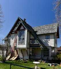 | John and Elsie McMillan House | 1.7 miles | 2015 |
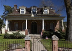 | John G. Wenke House | 1.8 miles | 1976 |
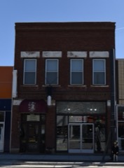 | Sturgis Commercial Block | 1.8 miles | 1975 |
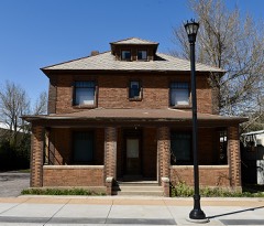 | Stephen and Maria Graf House | 2.0 miles | 2002 |
 | Erskine School | 2.1 miles | 1984 |
| National Archives record | The nomination case file for reference 73001747 in Record Group 79. |
| Meade County | All 27 listed properties in this county. |