 Block
From the record
One of 15 National Register listings published here for Charles Mix County · listed in 1975 · category: District.
Sources: the case file at the National Archives · the National Register database, National Park Service
Listed on the National Register of Historic Places in 1975.
One of 15 National Register listings published here for Charles Mix County · listed in 1975 · category: District.
Sources: the case file at the National Archives · the National Register database, National Park Service
Regional context, not property-specific evidence. The federal wildfire occurrence database lists 81 fires within 5 miles of Rising Hail Colony between 1997 and 2020, burning about 469 acres in total. 3 started naturally. 13 were recorded as arson. Distance is straight-line from the map coordinates, so a fire counted here may appear on a neighbouring settlement's page as well.
| Reported cause | Fires |
|---|---|
| Missing data/not specified/undetermined | 31 |
| Debris and open burning | 14 |
| Arson/incendiarism | 13 |
| Fireworks | 9 |
| Equipment and vehicle use | 5 |
| Misuse of fire by a minor | 5 |
| Natural | 3 |
| Power generation/transmission/distribution | 1 |
The most recent of them, most recent first, with the day each was reported and the service that recorded it.
| Date | Cause | Size | Reported by | Name on the report |
|---|---|---|---|---|
| 9 September 1997 | Natural | under an acre | Karl Mundt National Wildlife Refuge | MUNDT SU1 |
| 5 September 2012 | Missing data/not specified/undetermined | 1.0 acres | Yankton Agency | MARTY 1 |
| 11 September 2005 | Fireworks | 1.0 acres | Yankton Agency | A0805023 |
| 3 August 2003 | Debris and open burning | 5.0 acres | Yankton Agency | A0803008 |
| 2 August 2003 | Missing data/not specified/undetermined | 10 acres | Yankton Agency | A0803007 |
| 19 August 2014 | Missing data/not specified/undetermined | 20 acres | South Dakota Wildland Fire Suppression | GRANITE |
| 16 August 2012 | Equipment and vehicle use | 112 acres | Karl Mundt National Wildlife Refuge | KARL MUNDT |
| 16 August 2004 | Missing data/not specified/undetermined | 2.0 acres | Yankton Agency | BDRO |
Regional context, not property-specific evidence. The National Weather Service names Greenwood, the town this property stands in, in 26 storm reports between 1999 and 2025: 18 flood, 6 hail, 1 tornado, 1 thunderstorm wind. No death or injury is recorded in these reports. Each account below is quoted exactly as the forecast office filed it, from the NOAA Storm Events Database, and each date opens the federal record of that event.
| When | Event | Place named | Harm | What the report says |
|---|---|---|---|---|
| June 2024 | Flood | Greenwood | $3,000,000 | Rainfall amounts across Charles Mix County from June 20-22 generally ranged from 2 to 5 inches. This rainfall worsened some minor water issues from thunderstorms earlier in the week, especially near Choteau Creek.||Some overland flooding resulted in damage to many roads and culverts across the county. South Dakota Highway 46-50 was closed just west of Wagner in a construction zone where there was active work on replacing culverts. In addition, there were a few homes that reported water in their basements. Preliminary damage assessments estimate loss to public infrastructure to be 3 million dollars. |
| March 2019 | Flood | Greenwood | $330,000 | South Dakota Highway 46 was closed both east and west of Wagner due to water flowing over the roadway. Other flooding resulted in damage to public infrastructure including county and township roads and culverts. |
| September 2019 | Flood | Greenwood | $230,000 | Widespread areal flooding resulted after excessive rainfall from September 10-12, which brought 6.40 inches to Platte and 6.31 inches 2 miles northeast of Academy. Flooding resulted in crop losses and damage to public infrastructure including numerous county and township roads, culverts, and some bridges. Access was cut off to several homes with water rising to 6 to 12 inches deep across parts of Lake Andes. Crop loss estimates provided by the United States Department of Agriculture. |
| August 2019 | Flood | Greenwood | $25,000 | As flooding continued from July, the Missouri River near Verdel (gage site MRVN1) crested 0.82 feet above flood stage on August 31. High water closed numerous recreational boat ramps. The river remained at minor flood stage at the end of the month. |
| October 2019 | Flood | Greenwood | $5,000 | A continuation of flooding from September, the Missouri River near Verdel (gage site MRVN1) remained in flood throughout the month. The river crested 1.12 feet above flood stage on October 1, and again 1.08 feet above flood stage on October 18. High water levels led to the closing of many recreational boat ramps. The river remained in minor flood at the end of the month. Property damage costs are rough estimates. |
| September 2019 | Flood | Greenwood | $5,000 | As releases from Fort Randall Dam increased following the mid-month rainfall, the Missouri River near Verdel (gage site MRVN1) rose sharply into moderate flood stage and crested 1.17 feet above flood stage on September 21. High water levels led to the closing of many recreational boat ramps. The river remained in moderate flood at the end of the month. |
| July 2025 | Hail | Greenwood | - | A member of the public provided a photo of lime-sized hail. |
| May 2022 | Thunderstorm Wind | Greenwood | - | An attached garage was ripped from a single-family home and destroyed. |
| January 2020 | Flood | Greenwood | - | The Missouri River near Verdel (gage site MRVN1) briefly reached minor flood stage on January 21. The river crested 0.08 feet above flood stage, with only a very minor impact outside the recreational season. |
| June 2019 | Flood | Greenwood | - | During crop planting season, prolonged flooding led to the loss of or inability to plant crops across the area. Crop loss estimates provided by the United States Department of Agriculture. |
| June 2019 | Flood | Greenwood | - | A continuation of flooding from May, the Missouri River near Verdel (gage site MRVN1) crested 1.07 feet above flood stage on June 20. High water closed numerous recreational boat ramps. The river remained at minor flood stage at the end of the month. |
| November 2019 | Flood | Greenwood | - | A continuation of flooding from October, the Missouri River near Verdel (gage site MRVN1) remained in flood until the final day of the month. The river crested 0.91 feet above flood stage on November 6. High water levels maintained closure of many recreational boat ramps. |
| July 2019 | Flood | Greenwood | - | Flooding continued from June, with only a brief fall below flood stage from July 9-12. The Missouri River near Verdel (gage site MRVN1) crested 1.00 feet above flood stage on July 6, and again at 0.76 feet above flood stage on July 28. High water closed numerous recreational boat ramps. The river remained at minor flood stage at the end of the month. |
| March 2019 | Flood | Greenwood | - | While there was some contribution from rainfall (2.90 inches near Wagner) and snow melt, the crest severity along the Missouri River had at least a partial contribution from backwater flow from an uncontrolled release with the failure of Spencer Dam along the Niobrara River in Nebraska during the evening of March 13. A home south of Dante along River Bottom Road was surrounded by water. Major flooding resulted, as the Missouri River at Verdel (gage site MRVN1) crested second highest on record at 2.6 feet above flood stage on March 14. |
| May 2019 | Flood | Greenwood | - | Increased releases from upstream Fort Randall Dam along with heavy rainfall over the preceding week produced minor flooding on the Missouri River near Verdel (gage site MRVN1). A few recreational homes were subjected to flooding as the river rose to 0.75 feet above flood stage on May 30. The river remained in minor flood stage at the end of the month. |
| September 2019 | Flood | Greenwood | - | A continuation of flooding from August, the start of September was spent in minor flood stage. The Missouri River near Verdel (gage site MRVN1) crested 0.58 feet above flood stage on September 11. The excessive precipitation of September 10-12 resulted in a decrease in releases from Fort Randall Dam, which rapidly brought the river below flood stage by September 15. Impacts were mainly limited to inundation of agricultural land, as well as closing of numerous recreational boat ramps. |
| July 2018 | Flood | Greenwood | - | Minor flooding of mainly agricultural areas occurred as the Missouri River near Verdel (gage site MRVN1) crested 0.2 feet above flood stage on July 14. The river dropped briefly below flood stage mid-month, but returned above flood stage on July 20 and crested again 0.3 feet above flood stage on July 23. The river remained in minor flood through the end of the month. |
| September 2018 | Flood | Greenwood | - | Minor flooding of mainly agricultural areas occurred as the Missouri River near Verdel (gage site MRVN1) remained above flood stage for most of the month. A few recreational homes between Verdel and Niobrara were impacted by high water levels. The river crested 0.4 feet above flood stage on September 5, then dropped below flood stage from September 20 to September 29. A brief secondary crest occurred at flood stage on September 29, before quickly dropping below flood stage at 0000CST September 30. |
| October 2018 | Flood | Greenwood | - | Minor flooding of mainly agricultural areas occurred as the Missouri River near Verdel (gage site MRVN1) returned above flood stage mid month. A few recreational homes between Verdel and Niobrara were impacted by high water levels. The river crested 0.3 feet above flood stage on October 13, then quickly dropped below flood stage. |
| August 2018 | Flood | Greenwood | - | Minor flooding of mainly agricultural areas occurred as the Missouri River near Verdel (gage site MRVN1) remained above flood stage for most of the month. The river crested 0.4 feet above flood stage on August 16, but dropped briefly below flood stage from August 20 to August 23. The river remained in minor flood through the end of the month. |
| August 2009 | Hail | Greenwood | - | Large hail damaged vehicles and crops. The amount of property and crop damage was not known. |
| June 2018 | Hail | Greenwood | - | no account filed |
| June 2017 | Hail | Greenwood | - | no account filed |
| May 2015 | Hail | Greenwood | - | no account filed |
| May 2011 | Hail | Greenwood | - | no account filed |
| May 1999 | Tornado (F0) | Greenwood | - | no account filed |
No historic map-sheet match is published for this property yet. That does not mean no map exists. This record needs a coordinate-quality review before it can be joined to a sheet boundary. Browse the county's mapped places while that work is pending.
Other National Register properties close enough to walk or drive between, ordered by distance from this one. Both positions come from the same geocoding pass that matched these properties to their map sheets.
| Photograph | Property | Distance | Listed |
|---|---|---|---|
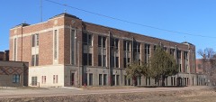 | Marty Mission School Gymnasium and St. Therese Hall | 3.0 miles | 2012 |
| Pickstown Fire and Police Station | 5.2 miles | 2020 | |
| Holy Fellowship Episcopal Church | 7.4 miles | 1975 |
| National Archives record | The nomination case file for reference 75001713 in Record Group 79. |
| Charles Mix County | All 15 listed properties in this county. |