 Block
From the record
15 National Register listings published here.
Sources: the National Register database, National Park Service
38 topographic sheets cover 16 settlements here, and 15 properties are on the National Register of Historic Places.
15 National Register listings published here.
Sources: the National Register database, National Park Service
Every property in this county listed on the National Register of Historic Places, with the year it was listed and the federal nomination document.
| Photograph | Property | Type | Listed | Reference |
|---|---|---|---|---|
 | Charles Mix County Courthouse | building | 1993 | 92001856 |
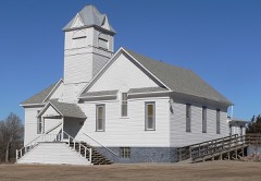 | Church of Christ in LaRoche Township | building | 1982 | 82003920 |
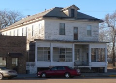 | Engel Hotel | building | 2012 | 12000035 |
 | Farmers State Bank of Platte | building | 1983 | 83003004 |
| Geddes Historic District | district | 1973 | 73001737 | |
| Henry Cool Park | district | 2011 | 11000083 | |
| Holy Fellowship Episcopal Church | building | 1975 | 75001712 | |
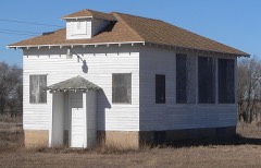 | Jacobson School | building | 2003 | 02001762 |
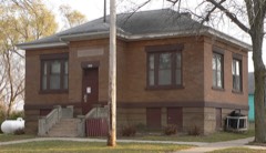 | Lake Andes Carnegie Library | building | 2000 | 00000598 |
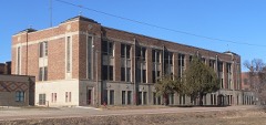 | Marty Mission School Gymnasium and St. Therese Hall | building | 2012 | 11001012 |
| Pickstown Fire and Police Station | building | 2020 | 100005109 | |
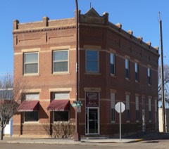 | Pratt & Cjolme Building | building | 2007 | 07000532 |
| Rising Hail Colony | district | 1975 | 75001713 | |
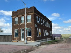 | Security State Bank of Dante | building | 2018 | 100003072 |
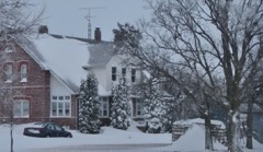 | Wagner House | building | 2007 | 07001209 |
Every wildfire the federal occurrence database records inside this county: 548 of them, burning about 7,827 acres. 16 started naturally and 31 were recorded as arson. Each settlement page carries the fires within five miles of it.
| Reported cause | Fires |
|---|---|
| Missing data/not specified/undetermined | 241 |
| Debris and open burning | 121 |
| Equipment and vehicle use | 50 |
| Fireworks | 41 |
| Arson/incendiarism | 31 |
| Misuse of fire by a minor | 20 |
| Natural | 16 |
| Recreation and ceremony | 8 |
| Railroad operations and maintenance | 7 |
| Smoking | 5 |
| Other causes | 4 |
| Power generation/transmission/distribution | 3 |
| Firearms and explosives use | 1 |
The five largest, by the area the report gives. None of them was recorded as arson.
| Date | Cause | Size | Reported by | Name on the report |
|---|---|---|---|---|
| 1 July 2002 | Equipment and vehicle use | 800 acres | Yankton Agency | REE |
| 2 May 2000 | Debris and open burning | 250 acres | Platte Volunteer Fire Department | 00-19 |
| 15 August 2000 | Equipment and vehicle use | 250 acres | Platte Volunteer Fire Department | 00-33 |
| 28 July 2006 | Recreation and ceremony | 201 acres | Yankton Agency | YST2006-17 |
| 18 March 2017 | Debris and open burning | 200 acres | Yankton Agency | DAM FIRE |
| 21 July 2012 | Missing data/not specified/undetermined | 200 acres | South Dakota Wildland Fire Suppression | RIVER RIDGE 12-023 |
| 23 April 2008 | Debris and open burning | 160 acres | South Dakota Wildland Fire Suppression | not named |
| 6 April 2000 | Debris and open burning | 150 acres | Armour Volunteer Fire Department | REZAC |
Every settlement page carries the fires within five miles of it - see the settlement index below.
The NOAA Storm Events Database holds 590 reports for this county, causing 1 death, 9 injuries and about $10,510,840 in recorded property damage. Each settlement page carries the reports that name it.
| Kind of event | Reports |
|---|---|
| Hail | 290 |
| Thunderstorm Wind | 182 |
| Flood | 49 |
| Tornado | 45 |
| Flash Flood | 20 |
| Heavy Rain | 2 |
| Lightning | 2 |
The most serious of them, by death, then injury, then recorded damage. The accounts are quoted exactly as the forecast office filed them.
| When | Event | Place named | Harm | What the report says |
|---|---|---|---|---|
| June 1973 | Tornado (F2) | not stated | 1 killed, 1 hurt, $25,000 | no account filed |
| July 2019 | Thunderstorm Wind | Academy | 3 hurt, $50,000 | Significant tree damage occurred at the Snake Creek Campground. Injuries occurred when tree branches fell on tents. Several campers rolled by high winds. |
| July 1981 | Tornado (F1) | not stated | 2 hurt | no account filed |
| May 1962 | Tornado (F3) | not stated | 2 hurt | no account filed |
| May 1962 | Tornado (F1) | not stated | 1 hurt | no account filed |
| June 2024 | Flood | Greenwood | $3,000,000 | Rainfall amounts across Charles Mix County from June 20-22 generally ranged from 2 to 5 inches. This rainfall worsened some minor water issues from thunderstorms earlier in the week, especially near Choteau Creek.||Some overland flooding resulted in damage to many roads and culverts across the county. South Dakota Highway 46-50 was closed just west of Wagner in a construction zone where there was active work on replacing culverts. In addition, there were a few homes that reported water in their basements. Preliminary damage assessments estimate loss to public infrastructure to be 3 million dollars. |
| June 1979 | Tornado (F1) | not stated | $2,500,000 | no account filed |
| June 2010 | Flash Flood | Lake Andes | $1,000,000 | Heavy rainfall of up to 6 inches caused widespread flash flooding of numerous roads, residences, fields, and other low areas, causing damage to and forcing evacuation of numerous residences. Many of the flooded roads were washed out. The Yankton Sioux reservation including the town of Marty was especially hard hit, with the tribal headquarters made unusable, and 63 families displaced from their homes.Flood damage was estimated at one million dollars by the county emergency manager. |
| July 1998 | Hail | Platte | $1,000,000 | Large hail destroyed or damaged crops, broke windows, and damaged vehicles and many farm buildings. The hail covered the ground in places and was accompanied by strong winds and heavy rain. |
| June 1994 | Hail | Aurora/Douglas/ | $500,000 | Hail fell along a strip two to four miles wide and 40 miles long. There was widespread crop damage and injuries to livestock were reported. Many windows were broken and shingles were damaged. Many vehicles were damaged, including one with all of the chrome stripped, all windows broken, and the car body completely dented. |
| March 2019 | Flood | Greenwood | $330,000 | South Dakota Highway 46 was closed both east and west of Wagner due to water flowing over the roadway. Other flooding resulted in damage to public infrastructure including county and township roads and culverts. |
| September 2019 | Flood | Greenwood | $230,000 | Widespread areal flooding resulted after excessive rainfall from September 10-12, which brought 6.40 inches to Platte and 6.31 inches 2 miles northeast of Academy. Flooding resulted in crop losses and damage to public infrastructure including numerous county and township roads, culverts, and some bridges. Access was cut off to several homes with water rising to 6 to 12 inches deep across parts of Lake Andes. Crop loss estimates provided by the United States Department of Agriculture. |
| June 2008 | Hail | Geddes | $200,000 | Large hail with numerous stones to golf ball size broke windows and damaged siding and roofs. Nearly every home in the north side of Geddes sustained window damage. The hail also damaged nearby crops. The amount of crop damage was not known, but was not believed to be extensive. |
| September 2019 | Flood | Platte Muni Arpt | $100,000 | Platte Creek near Platte (gage site PCPS2) responded sharply to 5 to 9 inches of rainfall between September 10-12 (6.31 inches near Academy and 6.29 inches at Platte) to reach the highest crest on record at 9.15 feet above flood stage on September 12. Innumerable county and township roads were inundated, with significant flooding of South Dakota Highway 1804. Platte Creek Road was washed out at the Lake Platte spillway starting around 0800CST on September 12. |
| June 2008 | Tornado (EF1) | Marty | $100,000 | A tornado severely damaged a home, destroyed outbuildings, and damaged storage bins at a farm near Ravinia. The tornado also caused tree damage along its path. |
| August 2002 | Thunderstorm Wind | Pickstown | $100,000 | Thunderstorm winds destroyed a metal utility shed, damaged campers, damaged several garage roofs, and caused tree damage, including a few large trees blown down. |
| July 2001 | Thunderstorm Wind | Dante | $100,000 | Thunderstorm winds destroyed part of a large cattle shed. There was no livestock in the building at the time. |
| August 2001 | Thunderstorm Wind | Lake Andes | $100,000 | Thunderstorm winds damaged trees and power lines, with numerous power poles reported down. Farm machinery and roofs were damaged, including a roof blown off a home. A mobile home was overturned. Crop damage was reported, but the amount of crop damage was not known. |
| August 2000 | Tornado (F1) | Wagner | $100,000 | A tornado damaged three homes, including a roof peeled off, and damaged a corn crop. The amount of crop damage was not known. |
| July 1998 | Hail | Platte | $100,000 | Large hail damaged crops, totally destroying some acreage, broke windows, dented vehicles, and damaged roofs. |
| August 1994 | Hail | Platte 2NE Lake | $100,000 | Widespread hail caused damage to vehicles and shingles, and broke windows. The hail also caused widespread and severe damage to crops. |
| July 1999 | Thunderstorm Wind | Academy | $100,000 | no account filed |
| June 2020 | Flash Flood | Marty | $50,000 | Water was flowing from 8 to 10 inches deep across 388th Avenue from two miles north of Marty into town. Some residents of Marty were evacuated due to flood waters. Rainfall in the area over just a few hours totaled 3.01 inches near Platte and 2.75 inches near Pickstown. Property damage costs are rough estimates. |
| August 2019 | Flood | Pickstown | $50,000 | A continuation of flooding from July, much of the month (August 1-13, 16-31) was spent in moderate flood stage. The Missouri River near Greenwood (gage site GRWS2) crested 1.71 feet above flood stage on August 31, the sixth highest crest on record. Impacts were mainly limited to inundation of agricultural land, as well as closing of numerous recreational boat ramps. The river remained at moderate flood stage at the end of the month. |
| June 2008 | Thunderstorm Wind | Ravinia | $50,000 | Thunderstorm winds blew the roof off a house, and blew down trees. |
| June 2003 | Tornado (F1) | Lake Andes | $50,000 | A tornado damaged or destroyed several buildings at an abandoned farm, and also caused tree damage. |
| July 2001 | Thunderstorm Wind | Wagner Arpt | $50,000 | Thunderstorm winds, including a heat burst, blew off a door and part of the roof of an airport hangar, bent a flagpole, blew down trees and power poles, and blew two farm wagons across a highway. The temperature rose over 20 degrees in a few minutes, briefly reaching 99 degrees. |
| July 2001 | Thunderstorm Wind | Pickstown | $50,000 | Thunderstorm winds caused damage to trees and camping vehicles, including one camper that was crushed under a falling tree. No one was injured. The winds also moved a garage off its foundation. |
| May 1993 | Hail | Dante | $50,000 | Tennis ball-size hail pounded a farm, killing two calves, breaking windows, damaging tractors, and leaving two inch holes in a utility shed and in the lawn. Other farms in the area also sustained some hail and wind damage. |
| June 1997 | Thunderstorm Wind | Platte | $50,000 | no account filed |
| June 1997 | Flash Flood | Platte | $30,000 | no account filed |
| August 2019 | Flood | Wagner | $25,000 | Heavy early morning rainfall resulted in ponding of 1 to 2 feet of water over parking lots in many areas on the west side of Wagner, including across the road from the fire station. |
| August 2019 | Flood | Greenwood | $25,000 | As flooding continued from July, the Missouri River near Verdel (gage site MRVN1) crested 0.82 feet above flood stage on August 31. High water closed numerous recreational boat ramps. The river remained at minor flood stage at the end of the month. |
| June 1971 | Tornado (F2) | not stated | $25,000 | no account filed |
| June 2001 | Thunderstorm Wind | Platte | $20,000 | Thunderstorm winds caused damage at a farm. Two grain bins were blown over, and one of them was moved a half mile. A calf shelter was destroyed, a livestock trailer and auger were overturned, and there was tree damage. |
| June 2021 | Thunderstorm Wind | Wagner | $15,000 | Numerous power lines were downed by thunderstorm winds in Wagner. Property damage costs are a rough estimate. |
| August 2020 | Thunderstorm Wind | Geddes | $13,000 | Three utility poles were snapped off above the ground. Property cost amounts are rough estimates. |
| August 2020 | Thunderstorm Wind | Lake Andes | $10,000 | Extensive tree damage was reported throughout Lake Andes. Property damage costs are rough estimates. |
| August 2019 | Flood | Platte Muni Arpt | $10,000 | Platte Creek near Platte (gage site PCPS2) crested 1.22 feet above flood stage on August 10, before falling back below flood stage later in the day. |
| August 2019 | Flood | Wagner | $10,000 | After waters had receded earlier in the day, a plugged culvert resulted in extensive ponding of water along South Dakota Highway 46/50 on the west side of Wagner. Additional flooding was reported near 5th Street on the south side of Wagner, near the location of the plugged culvert. |
| August 2019 | Flash Flood | Platte | $10,000 | Numerous roads were under water to a depth of 2 to 3 feet to the south of State Highway 44. |
| September 2019 | Flood | Pickstown | $10,000 | As releases from Fort Randall Dam increased following the mid-month rainfall, the Missouri River near Greenwood (gage site GRWS2) rose sharply into major flood stage and crested 2.47 feet above flood stage on September 30. Impacts were mainly limited to inundation of agricultural land, as well as the closing of numerous recreational boat ramps. The river remained in major flood at the end of the month. |
| July 2013 | Thunderstorm Wind | Lake Andes | $10,000 | Thunderstorm winds caused tree damage, including large limbs broken off. Some vehicles were dented by tree debris. Power lines were blown down and a power outage was reported. |
| June 2008 | Thunderstorm Wind | Geddes | $10,000 | Thunderstorm winds destroyed a large grain storage bin and blew down numerous tree branches. |
| June 2008 | Thunderstorm Wind | Ravinia | $10,000 | Thunderstorm winds blew down a 100 foot machine shed, and also blew down several trees. |
| July 2004 | Thunderstorm Wind | Marty | $10,000 | Thunderstorm winds rolled and damaged a deputy sheriff's vehicle. The deputy was not injured. |
| June 2003 | Hail | Wagner | $10,000 | Large hail cracked windows and damaged siding. |
| July 1999 | Thunderstorm Wind | Pickstown | $10,000 | no account filed |
| July 1999 | Thunderstorm Wind | Wagner | $10,000 | no account filed |
| July 2020 | Thunderstorm Wind | Platte Muni Arpt | $7,500 | Part of a roof was blow off a lean-to. Photos of damage provided by the Emergency Manager. Property damage amounts are rough estimates. |
| June 2020 | Hail | Wagner | $5,000 | Cars damaged due to hail up to golf ball size on the west side of Wagner. Property damage costs are rough estimates. |
| June 2020 | Flash Flood | Pickstown | $5,000 | Several county roads were flooded from rainfall which averaged 3 to 4 inches around the area during the overnight and morning hours. Up to 3.95 inches rainfall occurred near Pickstown. Property damage costs are rough estimates. |
| August 2019 | Flood | Wagner | $5,000 | Several inches of water was flowing over South Dakota Highway 50. |
| August 2019 | Flood | Ravinia | $5,000 | Several inches of water ponding over South Dakota Highway 50 east of Ravinia. |
| October 2019 | Flood | Greenwood | $5,000 | A continuation of flooding from September, the Missouri River near Verdel (gage site MRVN1) remained in flood throughout the month. The river crested 1.12 feet above flood stage on October 1, and again 1.08 feet above flood stage on October 18. High water levels led to the closing of many recreational boat ramps. The river remained in minor flood at the end of the month. Property damage costs are rough estimates. |
| October 2019 | Flood | Pickstown | $5,000 | A continuation of flooding from September, the Missouri River near Greenwood (gage site GRWS2) remained in major flood stage much of the month, and crested 2.51 feet above flood stage on October 18. Impacts were mainly limited to inundation of agricultural land, as well as the closing of numerous recreational boat ramps. The river remained in moderate flood at the end of the month. Property damage costs are rough estimates. |
| September 2019 | Flood | Greenwood | $5,000 | As releases from Fort Randall Dam increased following the mid-month rainfall, the Missouri River near Verdel (gage site MRVN1) rose sharply into moderate flood stage and crested 1.17 feet above flood stage on September 21. High water levels led to the closing of many recreational boat ramps. The river remained in moderate flood at the end of the month. |
| August 2010 | Thunderstorm Wind | Wagner | $5,000 | Thunderstorm winds blew down power poles and lines. |
| August 2010 | Thunderstorm Wind | Lake Andes | $5,000 | Thunderstorm winds caused widespread tree damage, including large limbs blown down. A car window was smashed by one falling limb. The winds also blew down power lines, causing a power outage. |
| May 2010 | Thunderstorm Wind | Platte | $5,000 | Thunderstorm winds blew down power poles and caused tree damage in Platte. The winds also destroyed a small shed and damaged equipment on a farm southwest of Platte. |
The Survey's mineral resources record lists 8 workings inside this county. 4 still produce and 4 are closed or unrecorded. Each settlement page carries the workings within five miles of it.
| Commodity | Workings |
|---|---|
| Sand and Gravel, Construction | 8 |
The least common of them first, because a county's hundredth gravel pit says nothing its first ten did not.
| Where | Site | Commodity | Status | Recorded |
|---|---|---|---|---|
| Gravel Pit | Sand and Gravel, Construction | Past Producer | ||
| Greenwood Colony Sand Pit | Sand and Gravel, Construction | Producer | ||
| Hobbs Pit | Sand and Gravel, Construction | Producer | ||
| Moyasis Pit | Sand and Gravel, Construction | Past Producer | ||
| Sly Sand & Gravel Pit | Sand and Gravel, Construction | Producer | ||
| Sly Sand & Gravel Pit | Sand and Gravel, Construction | Producer | ||
| Soukup Pit | Sand and Gravel, Construction | Past Producer | ||
| Wagner Ravinia Sand Pit | Sand and Gravel, Construction | Past Producer |
Named settlements recorded in the Geographic Names Information System, each with the topographic sheets covering it. Villages, hamlets and abandoned places alike. Each is shown with the nearest named watercourse or landform and the survey quadrangle it falls on.
Choteau Creek township · 57330 · Greenwood Colony quadrangle
9 sheets, 1955 to 1990
White Swan township · 57367 · Near Williamson Gulch · Fort Randall Dam quadrangle
10 sheets, 1955 to 1990
Signal township · 57369 · By Stony Point (historical) · Campbell Creek quadrangle
9 sheets, 1955 to 1990
No longer a settlement
The vanished settlements of Charles Mix County: the places named above that are no longer on the map.