 Block
From the record
One of 78 National Register listings published here for Yankton County · listed in 1980 · category: Building · built in 1910.
Sources: the case file at the National Archives · the National Register database, National Park Service
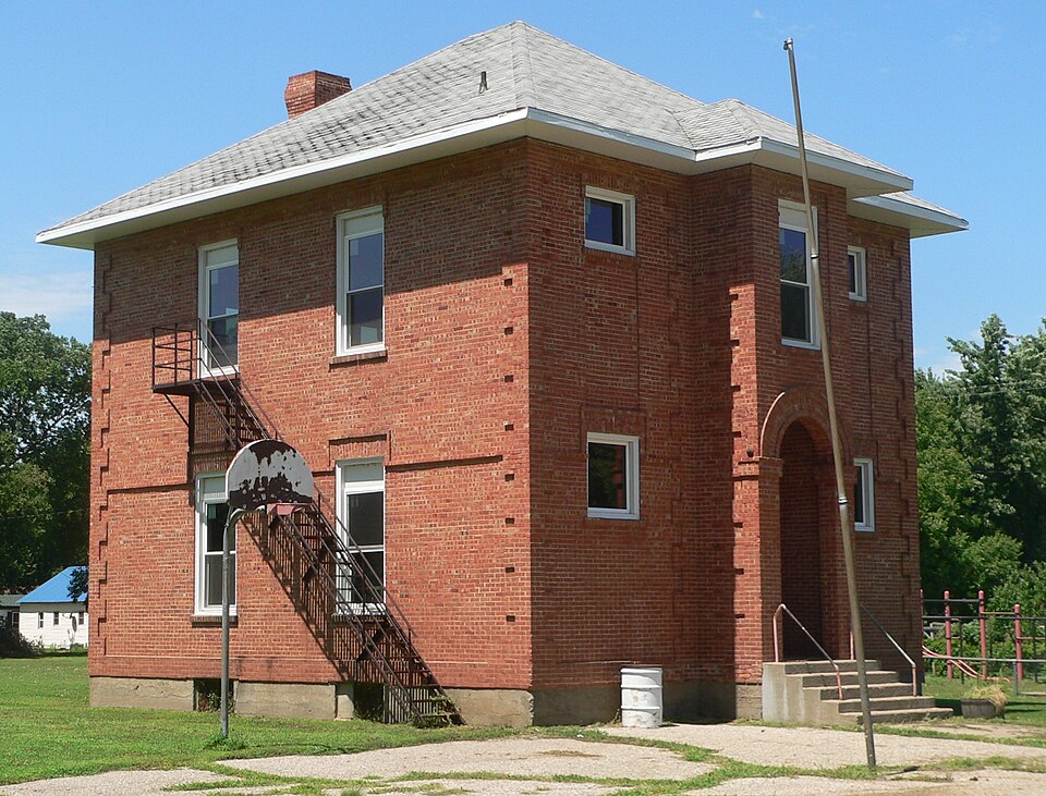
Built in 1910. Listed on the National Register of Historic Places in 1980.
One of 78 National Register listings published here for Yankton County · listed in 1980 · category: Building · built in 1910.
Sources: the case file at the National Archives · the National Register database, National Park Service
Regional context, not property-specific evidence. The federal wildfire occurrence database lists 50 fires within 5 miles of Utica Public School between 1999 and 2020, burning about 1,814 acres in total. None started naturally. None was recorded as arson. Distance is straight-line from the map coordinates, so a fire counted here may appear on a neighbouring settlement's page as well.
| Reported cause | Fires |
|---|---|
| Missing data/not specified/undetermined | 30 |
| Debris and open burning | 13 |
| Equipment and vehicle use | 5 |
| Smoking | 2 |
The most recent of them, most recent first, with the day each was reported and the service that recorded it.
| Date | Cause | Size | Reported by | Name on the report |
|---|---|---|---|---|
| 10 September 2012 | Missing data/not specified/undetermined | 1.0 acres | South Dakota Wildland Fire Suppression | UTICA OIL FIRE |
| 28 August 2012 | Missing data/not specified/undetermined | 1.0 acres | South Dakota Wildland Fire Suppression | TAOR OIL FIRE |
| 27 August 2012 | Missing data/not specified/undetermined | 20 acres | South Dakota Wildland Fire Suppression | HARRY'S FIRE |
| 10 August 2012 | Missing data/not specified/undetermined | 1.0 acres | South Dakota Wildland Fire Suppression | NEDVED |
| 9 July 2012 | Missing data/not specified/undetermined | under an acre | South Dakota Wildland Fire Suppression | FISCHER FIRE 1 |
| 7 July 2012 | Missing data/not specified/undetermined | 1.0 acres | South Dakota Wildland Fire Suppression | KOZY STATION |
| 3 July 2014 | Missing data/not specified/undetermined | 3.0 acres | South Dakota Wildland Fire Suppression | BAIL FIRE |
| 3 July 2012 | Missing data/not specified/undetermined | 44 acres | South Dakota Wildland Fire Suppression | STATE LAKE FIRE |
Regional context, not property-specific evidence. The federal mineral resources record lists 5 workings within 5 miles of Utica Public School: 5 past producers. None of them still produces. What was taken out: Sand and Gravel, Construction. Distance is straight-line from the map coordinates, so a quarry counted here may appear on a neighbouring settlement's page as well.
| Where | Site | Commodity | Status | Recorded |
|---|---|---|---|---|
| Gravel Pit | Sand and Gravel, Construction | Past Producer | ||
| Gravel Pit | Sand and Gravel, Construction | Past Producer | ||
| Gravel Pit | Sand and Gravel, Construction | Past Producer | ||
| Gravel Pit | Sand and Gravel, Construction | Past Producer | ||
| Gravel Pit | Sand and Gravel, Construction | Past Producer |
Regional context, not property-specific evidence. The National Weather Service names Utica, the town this property stands in, in 56 storm reports between 1997 and 2025: 37 hail, 10 flood, 8 thunderstorm wind, 1 flash flood. No death or injury is recorded in these reports. Each account below is quoted exactly as the forecast office filed it, from the NOAA Storm Events Database, and each date opens the federal record of that event.
| When | Event | Place named | Harm | What the report says |
|---|---|---|---|---|
| March 2019 | Flood | Utica | $9,800,000 | Street flooding in numerous intersections within the city of Yankton. A high number of flooded basements also reported, especially along Marne Creek. Other flooding resulted in extensive damage to public infrastructure including numerous county and township roads, culverts, and some bridges. |
| July 2009 | Hail | Utica | $500,000 | Large hail damaged vehicles and broke windows. The hail was accompanied by wind gusts up to 50 mph. |
| June 2024 | Flood | Utica | $227,000 | Rainfall amounts across Yankton County from June 20-22 ranged from 1 to 3 inches. Farther north and upstream, 5 to 10 inches of rain fell across portions of southeast South Dakota. This rainfall resulted in major flooding along the James River and extensive overland flooding along the adjoining flood plain. Some overland flooding also occurred along Clay Creek and the Marindahl Lake area. ||Multiple county roads succumbed to flood waters and were closed with some damages reported. Preliminary damage assessments estimate loss to public infrastructure to be nearly 227 thousand dollars. ||For additional information on river flooding, please see other flood entries for Yankton County. |
| September 2019 | Flood | Utica | $165,000 | Flooding resulted in crop losses and damage to public infrastructure including county and township roads and culverts. Crop loss estimates provided by the United States Department of Agriculture. |
| September 1997 | Thunderstorm Wind | Utica | $20,000 | Thunderstorm winds destroyed a pole barn, at least two utility poles, and caused tree damage. |
| June 2025 | Hail | Utica | - | Hail varying from pea to quarter size lasted 15 minutes. |
| May 2022 | Thunderstorm Wind | Utica | - | The grain elevator in Utica was severely damaged. |
| June 2021 | Thunderstorm Wind | Utica | - | Thunderstorm wind gusts were measured up to 60 mph. |
| June 2019 | Flood | Utica | - | During crop planting season, prolonged flooding led to the loss of or inability to plant crops across the area. Crop loss estimates provided by the United States Department of Agriculture. |
| March 2019 | Flood | Utica | - | Heavy rainfall (2.60 inches 8 miles west northwest of Springfield and 2.71 inches at Tyndall) and snow melt was the primary contributor to the flooding along Lewis and Clark Reservoir; however, the final level of crest had at least a partial contribution from an uncontrolled release with the failure of Spencer Dam along the Niobrara River in Nebraska during the evening of March 13. The highest crest on record resulted, as the Missouri River at Gavins Point Dam (gage site GPDN1) crested 2.02 feet above flood stage on March 15. |
| June 2013 | Hail | Utica | - | Large hail caused an unknown amount of damage to vehicles and windows. |
| May 2011 | Flood | Utica | - | Flooding along the Missouri River developed and then increased in late May as runoff from excessive upstream snowmelt and rain reached the area. Lowlands flooded included some roads near the River away from Lewis and Clark Lake. The river reached its highest May levels at the end of the month. |
| June 2011 | Flood | Utica | - | Flooding from upstream spring snowmelt and subsequent heavy rain continued to worsen for most of June. Lowlands along the river east of Lewis and Clark Lake including numerous roads, parks, recreational areas and several homes were flooded. The flooding included the Larson's Landing development west of Yankton with most homes and recreational vehicles there flooded. Thousands of acres of usually dry land were flooded, with several farms affected and farm equipment damaged. The highest stage at Yankton was 6.1 feet above flood stage on June 29th. |
| August 2011 | Flood | Utica | - | Flooding from upstream spring snowmelt and subsequent heavy rain continued at moderate to major levels at the start of August. Lowlands along the river east of Lewis and Clark Lake including numerous roads, parks, recreational areas and several homes remained flooded. The flooding included the Larson's Landing development west of Yankton with most homes and recreational vehicles there remaining flooded. Thousands of acres of usually dry land, including several farms, remained flooded. The river fell slowly during the month. The highest stage at Yankton was 5.5 feet above flood stage on August 1st. |
| July 2011 | Flood | Utica | - | Flooding from upstream spring snowmelt and subsequent heavy rain continued at major levels through July. Lowlands along the river east of Lewis and Clark Lake including numerous roads, parks, recreational areas and several homes remained flooded. The flooding included the Larson's Landing development west of Yankton with most homes and recreational vehicles there remaining flooded. Thousands of acres of usually dry land, including several farms, remained flooded. The river began a very slow general fall late in the month. The highest stage at Yankton was 6.1 feet above flood stage on July 7th. This was equal to the highest level recorded in June. |
| September 2011 | Flood | Utica | - | Flooding from upstream spring snowmelt and subsequent heavy rain decreased steadily, and ended late in the month. Flooding of roads, recreational areas, other parks, golf courses, and a few homes ended, including the flooding of homes and recreational vehicles at the Larson's Landing development. The highest stage at Yankton was 0.7 feet above flood stage on September 1st. |
| June 2009 | Thunderstorm Wind | Utica | - | Wind gusts to 60 mph were accompanied by quarter size hail. |
| June 2009 | Hail | Utica | - | Quarter size hail was accompanied by wind gusts up to 60 mph. |
| June 2008 | Flash Flood | Utica | - | Heavy rainfall of around 2 inches in 45 minutes caused flash flooding of roads and fields. |
| August 2007 | Thunderstorm Wind | Utica | - | Thunderstorm winds caused tree damage, including up to 6 inch diameter branches blown down. |
| June 2007 | Thunderstorm Wind | Utica | - | Thunderstorm winds caused tree damage, including large branches blown down. |
| May 2004 | Hail | Utica | - | Large hail damaged vehicles. The amount of damage was not known. |
| May 2004 | Hail | Utica | - | Large hail damaged vehicles, including the vehicle of the spotter who reported the hail. The amount of damage was not known. |
| June 2025 | Hail | Utica | - | no account filed |
| July 2023 | Hail | Utica | - | no account filed |
| July 2023 | Hail | Utica | - | no account filed |
| April 2022 | Hail | Utica | - | no account filed |
| June 2017 | Hail | Utica | - | no account filed |
| July 2014 | Hail | Utica | - | no account filed |
| September 2010 | Hail | Utica | - | no account filed |
| June 2009 | Hail | Utica | - | no account filed |
| June 2009 | Hail | Utica | - | no account filed |
| May 2008 | Hail | Utica | - | no account filed |
| June 2008 | Hail | Utica | - | no account filed |
| May 2008 | Hail | Utica | - | no account filed |
| May 2007 | Hail | Utica | - | no account filed |
| May 2007 | Hail | Utica | - | no account filed |
| April 2006 | Hail | Utica | - | no account filed |
| June 2006 | Thunderstorm Wind | Utica | - | no account filed |
| May 2004 | Hail | Utica | - | no account filed |
| May 2004 | Hail | Utica | - | no account filed |
| May 2004 | Hail | Utica | - | no account filed |
| May 2004 | Hail | Utica | - | no account filed |
| May 2004 | Hail | Utica | - | no account filed |
| May 2004 | Hail | Utica | - | no account filed |
| May 2004 | Hail | Utica | - | no account filed |
| July 2004 | Hail | Utica | - | no account filed |
| October 2002 | Hail | Utica | - | no account filed |
| May 2002 | Hail | Utica | - | no account filed |
| August 2002 | Hail | Utica | - | no account filed |
| August 2002 | Hail | Utica | - | no account filed |
| August 2002 | Hail | Utica | - | no account filed |
| August 2002 | Hail | Utica | - | no account filed |
| August 2002 | Hail | Utica | - | no account filed |
| May 2001 | Hail | Utica | - | no account filed |
| July 1998 | Thunderstorm Wind | Utica | - | no account filed |
No historic map-sheet match is published for this property yet. That does not mean no map exists. This record needs a coordinate-quality review before it can be joined to a sheet boundary. Browse the county's mapped places while that work is pending.
Other National Register properties close enough to walk or drive between, ordered by distance from this one. Both positions come from the same geocoding pass that matched these properties to their map sheets.
| Photograph | Property | Distance | Listed |
|---|---|---|---|
| Utica Depot | under 500 feet | 1980 | |
 | Utica Fire and City Hall | under 500 feet | 1980 |
 | DeJong House | under 500 feet | 1980 |
| Machacek Homestead | 1.6 miles | 1980 | |
 | Henjna Farmstead | 4.1 miles | 1980 |
| Mueller Homestead | 4.6 miles | 1980 |
| National Archives record | The nomination case file for reference 80003756 in Record Group 79. |
| Yankton County | All 78 listed properties in this county. |