
BlockBefore
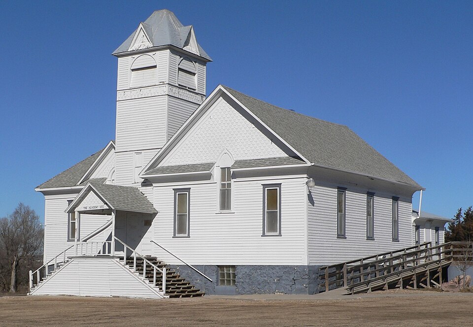
Photograph of Church of Christ in LaRoche Township
Photograph by Ammodramus, CC0 1.0. Via Wikimedia Commons.

Church of Christ in LaRoche Township

Listed on the National Register of Historic Places in 1982.

From the record

“Church of Christ in LaRoche Township is a church in Academy, South Dakota. It was added to the National Register of Historic Places in 1982.”

Wikipedia article Church of Christ in LaRoche Township, CC BY-SA 4.0.

One of 15 National Register listings published here for Charles Mix County · listed in 1982 · category: Building.

Sources: the Wikipedia article · the case file at the National Archives · the National Register database, National Park Service

The listing

  • What is counted as historic. The nomination lists 1 building as contributing to the listing.
  • Address. SD 50, Academy, 57369
  • When was it listed? July 1982
  • Category. building
  • Township. La Roche township
  • National Register reference number. 82003920 - the number the National Park Service assigned this property when it was listed, and the key its nomination file is catalogued under at the National Archives.

Fires near this property

9 since 2006

Regional context, not property-specific evidence. The federal wildfire occurrence database lists 9 fires within 5 miles of Church of Christ in LaRoche Township between 2006 and 2017, burning about 297 acres in total. 2 started naturally. None was recorded as arson. Distance is straight-line from the map coordinates, so a fire counted here may appear on a neighbouring settlement's page as well.

Reported cause Fires
Equipment and vehicle use4
Missing data/not specified/undetermined3
Natural2

The most recent of them, most recent first, with the day each was reported and the service that recorded it.

DateCause SizeReported by Name on the report
31 August 2010Natural1.0 acresSouth Dakota Wildland Fire SuppressionPLATTE COLONY #3
9 July 2017Natural2.0 acresSouth Dakota Wildland Fire SuppressionNEPODAL TREE
14 July 2006Equipment and vehicle use150 acresSouth Dakota Wildland Fire Suppressionnot named
14 July 2006Equipment and vehicle use100 acresSouth Dakota Wildland Fire Suppressionnot named
14 May 2011Missing data/not specified/undetermined20 acresSouth Dakota Wildland Fire SuppressionTJEERDSMA RX 11-014
25 February 2009Equipment and vehicle useunder an acreSouth Dakota Wildland Fire Suppressionnot named
23 February 2012Missing data/not specified/undetermined2.0 acresSouth Dakota Wildland Fire SuppressionMIDNIGHT 12-004
6 October 2011Missing data/not specified/undetermined20 acresSouth Dakota Wildland Fire SuppressionR JOHNSON 11-031

Every fire recorded in Charles Mix County

Storms near this property

53 since 1994

Regional context, not property-specific evidence. The National Weather Service names Academy, the town this property stands in, in 53 storm reports between 1994 and 2025: 28 thunderstorm wind, 21 hail, 4 flood. The reports record 3 injuries. Each account below is quoted exactly as the forecast office filed it, from the NOAA Storm Events Database, and each date opens the federal record of that event.

WhenEvent Place namedHarm What the report says
July 2019Thunderstorm WindAcademy3 hurt, $50,000Significant tree damage occurred at the Snake Creek Campground. Injuries occurred when tree branches fell on tents. Several campers rolled by high winds.
July 1999Thunderstorm WindAcademy$100,000no account filed
August 2010Thunderstorm WindAcademy$5,000Thunderstorm winds blew a wagon into a home, damaging the home. The winds also blew a door off a barn.
August 2009HailAcademy$1,000Large hail cracked windows and whitened the ground.
July 2025Thunderstorm WindAcademy-Thunderstorm wind gusts measured by a Road Weather Information System sensor 13 miles west of Platte.
July 2025Thunderstorm WindAcademy-Severe thunderstorm wind gusts were measured by a Road Weather Information System sensor at the Platte-Winner Bridge. A peak wind gust of 69 mph occurred at 1648 CST.
June 2025Thunderstorm WindAcademy-The South Dakota Mesonet site 3 NNW Academy measured a 69 mph severe wind gust at 1944 CST with a peak of 71 mph at 1947 CST.
June 2025Thunderstorm WindAcademy-Thunderstorm wind gusts measured by SD RWIS Platte-Winner Bridge.
July 2024Thunderstorm WindAcademy-An extended period of damaging thunderstorm winds occurred at the South Dakota Road Weather Information System site 14 miles west of Platte. Winds first reached severe levels at 135 am CST and peaked at 75 mph at 143 am CST. A secondary peak of 68 mph occurred at 233 am CST.
August 2022Thunderstorm WindAcademy-A thunderstorm wind gust of 59 mph was measured by South Dakota Road Weather Information System site SD554 14 miles west of Platte.
June 2022Thunderstorm WindAcademy-A thunderstorm wind gust of 69 mph was measured by South Dakota Road Weather Information System site SD554 14 miles west of Platte. Crop damage is an estimate from insured losses. Information provided by the United States Department of Agriculture.
July 2022Thunderstorm WindAcademy-A short duration of thunderstorm wind gusts around 60 mph was measured by South Dakota Road Weather Information System site SD554 14 miles west of Platte. A peak wind gust of 63 mph occurred at 1237CST.
June 2020Thunderstorm WindAcademy-Wind gust to 60 mph measured by a personal weather station.
June 2020Thunderstorm WindAcademy-Wind gust of 65 mph was measured by a personal weather station.
August 2020Thunderstorm WindAcademy-South Dakota RWIS site SD554 measured a peak wind gust of 60 mph.
July 2020Thunderstorm WindAcademy-South Dakota RWIS Station SD554 at the Platte-Winner bridge measured a wind gust to 65 mph.
July 2020Thunderstorm WindAcademy-South Dakota RWIS station SD554 14 miles west of Platte near the Platte-Winner bridge measured a peak wind gust of 72 mph.
July 2019Thunderstorm WindAcademy-DOT RWIS measured 115 mph wind gust.
July 2018Thunderstorm WindAcademy-Damage to trees and crops.
June 2018Thunderstorm WindAcademy-Grain trailers were tipped over by high thunderstorm winds, along with numerous large branches down.
June 2015Thunderstorm WindAcademy-Thunderstorm winds caused tree damage.
August 2014HailAcademy-Large hail covered the ground, and caused an unknown amount of crop damage.
May 2011FloodAcademy-Flooding along the Missouri River developed and then increased in late May as runoff from excessive upstream snowmelt and rain reached the area. Lowlands flooded included camping and other recreational facilities, as well as some roads. The river reached its highest May stage at 3.2 feet above flood stage near Greenwood at the end of the month.
June 2011FloodAcademy-Flooding from upstream spring snowmelt and subsequent heavy rain continued to worsen for most of June. Lowlands along the river including numerous roads and recreational areas and a few homes were flooded. The highest stage near Greenwood was a record 8.8 feet above flood stage at the end of the month.
August 2011FloodAcademy-Flooding from upstream spring snowmelt and subsequent heavy rain continued at major levels at the start of August. Lowlands along the river including numerous roads and recreational areas and some homes remaining flooded. The river fell slowly during most of the month. The highest stage near Greenwood was 8.2 feet above flood stage on August 6th.
July 2011FloodAcademy-Flooding from upstream spring snowmelt and subsequent heavy rain continued at major to record levels through July. Lowlands along the river including numerous roads and recreational areas and some homes remained flooded. The river began a very slow general fall late in the month. The highest stage near Greenwood was a record 8.9 feet above flood stage on July 12th.
August 2010Thunderstorm WindAcademy-Thunderstorm winds caused tree damage, including branches blown down.
August 2009Thunderstorm WindAcademy-Strong thunderstorm winds shook the house.
August 2009Thunderstorm WindAcademy-Thunderstorm winds caused tree damage, including several branches blown down.
July 2008Thunderstorm WindAcademy-Thunderstorm winds blew the door off a shed.
June 2008HailAcademy-Large hail was accompanied by heavy rainfall of 2.15 inches.
July 1994Thunderstorm WindAcademy-Thunderstorm Winds almost turned a vehicle over.
June 2020HailAcademy-no account filed
June 2019HailAcademy-no account filed
August 2019Thunderstorm WindAcademy-no account filed
August 2019HailAcademy-no account filed
September 2019Thunderstorm WindAcademy-no account filed
June 2017HailAcademy-no account filed
May 2016HailAcademy-no account filed
July 2015Thunderstorm WindAcademy-no account filed
May 2012HailAcademy-no account filed
August 2008HailAcademy-no account filed
July 2002HailAcademy-no account filed
June 1999HailAcademy-no account filed
May 1999HailAcademy-no account filed
July 1996HailAcademy-no account filed

Every storm recorded in Charles Mix County

Map coverage status

No historic map-sheet match is published for this property yet. That does not mean no map exists. This record needs a coordinate-quality review before it can be joined to a sheet boundary. Browse the county's mapped places while that work is pending.

Sources for this property

National Archives recordThe nomination case file for reference 82003920 in Record Group 79.
Wikipedia articleCommunity-written account of this property, licensed CC BY-SA.
Charles Mix CountyAll 15 listed properties in this county.

Provenance

  • Listing record. National Park Service National Register of Historic Places, listed-properties dataset, current to 2026-05-22.
  • Map join. Address geocoded through the United States Census geocoder, then tested against the published boundary of every sheet in the USGS Historical Topographic Map Collection.
  • How this page is made. Listing fields come from federal records; map-sheet coverage is a labelled coordinate-to-boundary calculation, not a source-field claim.
  • Wildfire. Short, Karen C. 2022. Spatial wildfire occurrence data for the United States, 1992-2020 [FPA_FOD_20221014]. 6th Edition. Fort Collins, CO: Forest Service Research Data Archive. https://doi.org/10.2737/RDS-2013-0009.6 Collected with United States Government funding and usable without additional permissions or fees.
  • Storms. NOAA National Centers for Environmental Information, Storm Events Database https://www.ncei.noaa.gov/stormevents/ A work of the United States government, no copyright under 17 U.S.C. 105. Narratives are quoted verbatim from the National Weather Service report and are not edited or summarised.