
BlockBefore
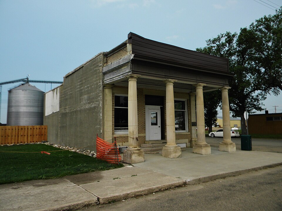
Photograph of Bank of Bowdle
Photograph by Jon Roanhaus, CC BY-SA 3.0. Via Wikimedia Commons.

Bank of Bowdle

Built in 1908. Listed on the National Register of Historic Places in 1985.

From the record

“The Bank of Bowdle is a one-story cream-colored brick building with a portico supported by Doric columns, located at 3026 Main St., Bowdle, South Dakota. It was built in 1908, and was listed on the National Register of Historic Places in 1985.”

Wikipedia article Bank of Bowdle, CC BY-SA 4.0.

One of 11 National Register listings published here for Edmunds County · listed in 1985 · category: Building · built in 1908.

Sources: the Wikipedia article · the case file at the National Archives · the National Register database, National Park Service

The listing

  • What is counted as historic. The nomination lists 1 building as contributing to the listing.
  • Address. 3026 Main St., Bowdle, 57428
  • When was it listed? January 1985
  • Category. building
  • Township. Bowdle township
  • When was it built? 1908
  • National Register reference number. 85000183 - the number the National Park Service assigned this property when it was listed, and the key its nomination file is catalogued under at the National Archives.

Fires near this property

14 since 2006

Regional context, not property-specific evidence. The federal wildfire occurrence database lists 14 fires within 5 miles of Bank of Bowdle between 2006 and 2019, burning about 2,023 acres in total. 3 started naturally. None was recorded as arson. Distance is straight-line from the map coordinates, so a fire counted here may appear on a neighbouring settlement's page as well.

Reported cause Fires
Missing data/not specified/undetermined7
Natural3
Equipment and vehicle use3
Debris and open burning1

The most recent of them, most recent first, with the day each was reported and the service that recorded it.

DateCause SizeReported by Name on the report
4 September 2017Naturalunder an acreSouth Dakota Wildland Fire SuppressionHOFFMAN
6 August 2019Naturalunder an acreSouth Dakota Wildland Fire SuppressionGEIER FIRE
8 July 2017Equipment and vehicle useunder an acreSouth Dakota Wildland Fire SuppressionSCHOCK
18 July 2006Natural2,000 acresSouth Dakota Wildland Fire Suppressionnot named
7 June 2013Missing data/not specified/undetermined1.0 acresEdmunds CountyRR
7 June 2013Missing data/not specified/undetermined1.0 acresEdmunds CountyRR 2
7 May 2013Missing data/not specified/undetermined1.0 acresEdmunds CountyHAAR
17 May 2018Missing data/not specified/undeterminedunder an acreSouth Dakota Wildland Fire SuppressionBOSCHEE

Every fire recorded in Edmunds County

Storms near this property

60 of 88 shown

Regional context, not property-specific evidence. The National Weather Service names Bowdle, the town this property stands in, in 88 storm reports between 1994 and 2025: 42 hail, 26 thunderstorm wind, 12 flood, 4 tornado. No death or injury is recorded in these reports. Each account below is quoted exactly as the forecast office filed it, from the NOAA Storm Events Database, and each date opens the federal record of that event.

WhenEvent Place namedHarm What the report says
April 2019FloodBowdle$39,600no account filed
July 2020Thunderstorm WindBowdle-Estimated seventy-five mph winds.
March 2019FloodBowdle-Many roads were flooded throughout Edmunds county with many of them closed. Also, several structures were threatened by the high water.
July 2019Thunderstorm WindBowdle-A small outbuilding was blown down.
June 2018Thunderstorm WindBowdle-Ten power poles along with many trees were downed by estimated ninety mph winds.
September 2017Thunderstorm WindBowdle-Sixty mph winds along with ping pong size hail caused broken windows along with stripping some corn.
May 2016Tornado (EF0)Bowdle-The first weak tornado touched down quickly in an open field southwest of Bowdle.
May 2016Tornado (EF0)Bowdle-A second weak tornado touched down briefly in an open field.
August 2012HailBowdle-Golf ball size hail caused damage to vehicles.
July 2011Thunderstorm WindBowdle-Sixty mph winds downed some large branches.
March 2011FloodBowdle-Many county and township roads were flooded and damaged in Edmunds county including U.S. Highway 12. The flooding of U.S. Highway 12 severely affected the busy highway traffic. Several roads were also closed across the county.
April 2011FloodBowdle-Snowmelt runoff flooded and damaged many roads throughout Edmunds county. The flooding of U.S. Highway 12 caused the most impact to travel. The frequently traveled east/west highway was eventually closed with traffic being detoured.
May 2011FloodBowdle-Previous snowmelt water along with above normal May rainfall kept many roads flooded and damaged throughout Edmunds county. The flooding of U.S. Highway 12 caused the most impact to travel. The highway remained closed near Roscoe with the traffic being detoured.
June 2011FloodBowdle-A very wet spring along with much above normal June rainfall kept many roads flooded and damaged throughout Edmunds county. The flooding of U.S. Highway 12 caused the most impact to travel. The highway remained closed near Roscoe with the traffic being detoured. The flooding continued into July.
May 2010Tornado (EF4)Bowdle-An EF2 tornado in eastern Walworth county crossed into western Edmunds county and intensified into a large EF4 tornado as it struck several farms in its path. At the first farm, several large cottonwood trees were uprooted along with damage to several trailers. Three grain bins were also destroyed with debris located several hundred yards to the northeast. The residence suffered some shingle and antenna damage. The tornado then tracked northeast to a second farm where several outbuildings were damaged or destroyed along with widespread tree damage. The main residence at this location suffered no damage. Several grain cars were also rolled about 100 yards into the trees behind the house.||The large tornado continued to track northeast to a third farm to the north of Bowdle. The main residence suffered major damage to walls with part of the roof structure removed. Widespread tree damage was sustained with many of the |trees completely debarked with only the stumps of the largest branches |remaining. Two large garages were completely destroyed with the |concrete slab wiped clean. The vehicles in one garage were |rolled or tossed from 25 to 100 yards away. It is estimated that one |vehicle flew through the air 75 to 100 yards resting in the tree |shelter belt to the north of the residence. Several other outbuildings were completely destroyed.||The tornado then toppled six to eight metal power transmission towers as it moved to the north of the farm. One tower was sheared off from the concrete footings and traveled an estimated 400 yards. Ground scouring was visible along the path of these towers.||The large tornado continued to track east crossing over State Highway 47 where a state radio tower was toppled. The tornado lifted shortly thereafter. The highest wind speeds were estimated to be from 166 to 200 mph.
June 2005Thunderstorm WindBowdle-Eighty mph winds leveled a silo, damaged two barns, and uprooted many trees.
July 2005Thunderstorm WindBowdle-Many branches were downed in Bowdle.
August 2004Thunderstorm WindBowdle-Strong winds brought down many tree branches.
July 2001Tornado (F2)Bowdle-A tornado touched down and heavily damaged a house. The attached garage was totally destroyed with two vehicles badly damaged. The metal roof was ripped off of the barn with three outbuildings destroyed. Five telephone/power poles were broken off with 1/2 to 3/4 of a mile of power lines down. Also, a small windmill was wrapped around a power pole.
June 2025HailBowdle-no account filed
June 2025Thunderstorm WindBowdle-no account filed
July 2025Thunderstorm WindBowdle-no account filed
July 2025HailBowdle-no account filed
August 2025HailBowdle-no account filed
August 2025Thunderstorm WindBowdle-no account filed
August 2025HailBowdle-no account filed
May 2024Thunderstorm WindBowdle-no account filed
June 2024Thunderstorm WindBowdle-no account filed
April 2023FloodBowdle-no account filed
May 2022Thunderstorm WindBowdle-no account filed
July 2022Thunderstorm WindBowdle-no account filed
May 2021Thunderstorm WindBowdle-no account filed
August 2021Thunderstorm WindBowdle-no account filed
July 2020Thunderstorm WindBowdle-no account filed
July 2020HailBowdle-no account filed
June 2020HailBowdle-no account filed
June 2020Thunderstorm WindBowdle-no account filed
June 2019FloodBowdle-no account filed
August 2019HailBowdle-no account filed
May 2019FloodBowdle-no account filed
September 2018HailBowdle-no account filed
June 2017HailBowdle-no account filed
September 2017HailBowdle-no account filed
June 2014HailBowdle-no account filed
September 2013Thunderstorm WindBowdle-no account filed
August 2012HailBowdle-no account filed
July 2011HailBowdle-no account filed

Every storm recorded in Edmunds County

Map coverage status

No historic map-sheet match is published for this property yet. That does not mean no map exists. This record needs a coordinate-quality review before it can be joined to a sheet boundary. Browse the county's mapped places while that work is pending.

Sources for this property

National Archives recordThe nomination case file for reference 85000183 in Record Group 79.
Wikipedia articleCommunity-written account of this property, licensed CC BY-SA.
Edmunds CountyAll 11 listed properties in this county.

Provenance

  • Listing record. National Park Service National Register of Historic Places, listed-properties dataset, current to 2026-05-22.
  • Map join. Address geocoded through the United States Census geocoder, then tested against the published boundary of every sheet in the USGS Historical Topographic Map Collection.
  • How this page is made. Listing fields come from federal records; map-sheet coverage is a labelled coordinate-to-boundary calculation, not a source-field claim.
  • Wildfire. Short, Karen C. 2022. Spatial wildfire occurrence data for the United States, 1992-2020 [FPA_FOD_20221014]. 6th Edition. Fort Collins, CO: Forest Service Research Data Archive. https://doi.org/10.2737/RDS-2013-0009.6 Collected with United States Government funding and usable without additional permissions or fees.
  • Storms. NOAA National Centers for Environmental Information, Storm Events Database https://www.ncei.noaa.gov/stormevents/ A work of the United States government, no copyright under 17 U.S.C. 105. Narratives are quoted verbatim from the National Weather Service report and are not edited or summarised.