 Block
From the record
One of 42 National Register listings published here for Brown County · listed in 1990 · category: Building · built in 1893.
Sources: the case file at the National Archives · the National Register database, National Park Service
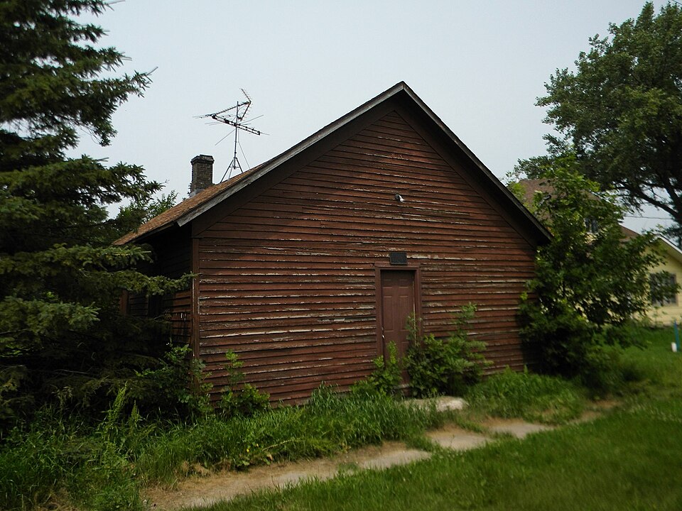
Built in 1893. Listed on the National Register of Historic Places in 1990.
One of 42 National Register listings published here for Brown County · listed in 1990 · category: Building · built in 1893.
Sources: the case file at the National Archives · the National Register database, National Park Service
Regional context, not property-specific evidence. The federal wildfire occurrence database lists 6 fires within 5 miles of Brown Hall between 2015 and 2020, burning about 31 acres in total. 2 started naturally. None was recorded as arson. Distance is straight-line from the map coordinates, so a fire counted here may appear on a neighbouring settlement's page as well.
| Reported cause | Fires |
|---|---|
| Equipment and vehicle use | 3 |
| Natural | 2 |
| Debris and open burning | 1 |
The most recent of them, most recent first, with the day each was reported and the service that recorded it.
| Date | Cause | Size | Reported by | Name on the report |
|---|---|---|---|---|
| 9 May 2020 | Natural | under an acre | South Dakota Wildland Fire Suppression | BALES |
| 8 May 2020 | Equipment and vehicle use | under an acre | South Dakota Wildland Fire Suppression | FLEMMER |
| 17 May 2018 | Natural | under an acre | South Dakota Wildland Fire Suppression | EDWARDS |
| 6 April 2015 | Equipment and vehicle use | 25 acres | South Dakota Wildland Fire Suppression | 15FFD11 |
| 6 April 2015 | Equipment and vehicle use | under an acre | South Dakota Wildland Fire Suppression | WAYNES FIRE |
| 13 November 2017 | Debris and open burning | 5.0 acres | South Dakota Wildland Fire Suppression | ACHEN |
Regional context, not property-specific evidence. The National Weather Service names Barnard, the town this property stands in, in 37 storm reports between 2002 and 2024: 19 hail, 10 thunderstorm wind, 6 tornado, 1 funnel cloud. No death or injury is recorded in these reports. Each account below is quoted exactly as the forecast office filed it, from the NOAA Storm Events Database, and each date opens the federal record of that event.
| When | Event | Place named | Harm | What the report says |
|---|---|---|---|---|
| August 2021 | Thunderstorm Wind | Barnard | - | Seventy mph winds combined with pea to dime sized hail to cause extensive crop damage. A couple of trees were downed as well. |
| June 2020 | Thunderstorm Wind | Barnard | - | Estimated seventy mph winds took off a section of a barn roof. |
| June 2020 | Thunderstorm Wind | Barnard | - | Estimated eighty mph winds tore some roof panels off an old barn. Two calf sheds were also pushed northeast when their support poles that they were chained to, snapped. |
| June 2020 | Thunderstorm Wind | Barnard | - | Several trees were downed in Barnard by seventy-five mph winds. Some fences were also damaged. |
| June 2012 | Hail | Barnard | - | Golf ball hail caused some damage to crops. |
| August 2012 | Hail | Barnard | - | Quarter size hail along with strong winds caused some minor damage to the siding on a house and stripped leaves off crops. |
| August 2010 | Thunderstorm Wind | Barnard | - | Seventy mph winds took the roof off of a shed and tipped an auger over. |
| May 2010 | Tornado (EF0) | Barnard | - | A tornado entered into western Brown county from southeast Mcpherson county. The tornado was an EF2 before entering Brown county. The tornado slowly dissipated shortly after entering the county with some tree damage observed. |
| May 2010 | Thunderstorm Wind | Barnard | - | Damaging winds downed two very large trees which had fallen across a road. A farmer had the doors ripped off his barn with a horse trailer being moved 150 feet. Another farmer had major damage to several outbuildings. |
| June 2002 | Hail | Barnard | - | Softball size hail fell just south of Barnard damaging a law officer's vehicle. |
| June 2024 | Hail | Barnard | - | no account filed |
| June 2024 | Hail | Barnard | - | no account filed |
| June 2024 | Hail | Barnard | - | no account filed |
| June 2022 | Thunderstorm Wind | Barnard | - | no account filed |
| April 2020 | Hail | Barnard | - | no account filed |
| June 2020 | Hail | Barnard | - | no account filed |
| June 2020 | Thunderstorm Wind | Barnard | - | no account filed |
| June 2019 | Hail | Barnard | - | no account filed |
| April 2019 | Flood | Barnard | - | no account filed |
| August 2018 | Hail | Barnard | - | no account filed |
| July 2017 | Hail | Barnard | - | no account filed |
| June 2015 | Thunderstorm Wind | Barnard | - | no account filed |
| July 2015 | Hail | Barnard | - | no account filed |
| July 2015 | Hail | Barnard | - | no account filed |
| July 2013 | Hail | Barnard | - | no account filed |
| July 2010 | Hail | Barnard | - | no account filed |
| July 2010 | Hail | Barnard | - | no account filed |
| May 2010 | Funnel Cloud | Barnard | - | no account filed |
| May 2008 | Hail | Barnard | - | no account filed |
| August 2007 | Thunderstorm Wind | Barnard | - | no account filed |
| August 2007 | Hail | Barnard | - | no account filed |
| May 2005 | Hail | Barnard | - | no account filed |
| June 2002 | Tornado (F1) | Barnard | - | no account filed |
| June 2002 | Tornado (F3) | Barnard | - | no account filed |
| June 2002 | Tornado (F4) | Barnard | - | no account filed |
| June 2002 | Tornado (F0) | Barnard | - | no account filed |
| June 2002 | Tornado (F0) | Barnard | - | no account filed |
No historic map-sheet match is published for this property yet. That does not mean no map exists. This record needs a coordinate-quality review before it can be joined to a sheet boundary. Browse the county's mapped places while that work is pending.
Other National Register properties close enough to walk or drive between, ordered by distance from this one. Both positions come from the same geocoding pass that matched these properties to their map sheets.
| Photograph | Property | Distance | Listed |
|---|---|---|---|
 | Aurland United Norwegian Lutheran Church | 4.7 miles | 1982 |
 | Martilla-Pettingel and Gorder General Merchandise Store | 6.9 miles | 1985 |
| National Archives record | The nomination case file for reference 89002336 in Record Group 79. |
| Brown County | All 42 listed properties in this county. |