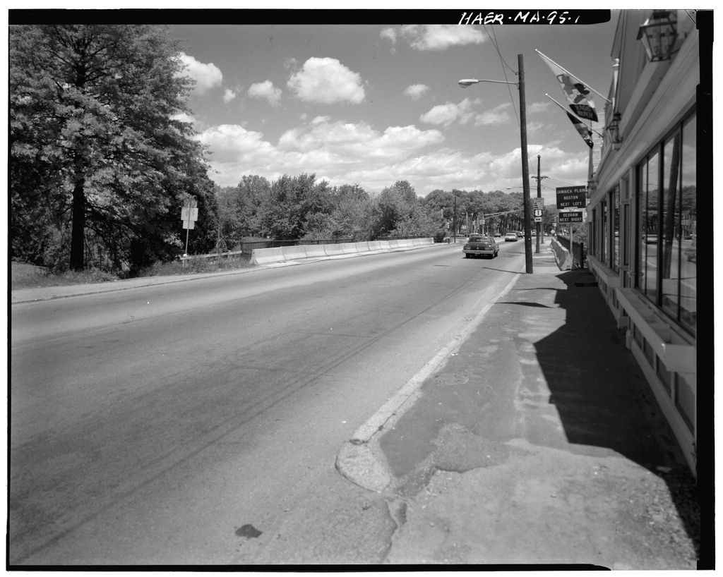
Documentation of the Spring Street Bridge is part of the Massachusetts Historic Bridge Recording Project, conducted during the summer of under the co-sponsorship of HABS/HAER and the Massachusetts Department of Public Works, in cooperation with the Massachusetts Historical Commission. John Healey, HAER Historian, August SPRING STREET BRIDGE (VINE ROCK BRIDGE) HAER No. MA-95 (page 2) Description The Spring Street Bridge, also known as the Lower Crossing, and referred to in county documents as the "Vine Rock Bridge," is a five-span, masonry arch structure spanning the Charles River, as it meanders about the former water meadows forming Dedham Island. Originally a stone structure, the bridge has had substantial concrete additions made to both sides.
Indeed, it is only upon more detailed examination that the arch soffits of the original bridge may be observed, entombed within the flanking concrete. Located at the site of a river crossing since the present bridge stands one-eighth of a mile upstream from the site of the Vine Rock Bridge which provided safe passage across the waters between and Today, the much-widened structure carries Route 109 as it cuts across the head of Dedham island, crossing the Charles both here and a mile farther south, also on Bridge Street. At this point, the Charles River is the boundary between Dedham in Norfolk County, and Boston in Suffolk County, although at the time of the bridge's construction both lay within the former county.
Description of the bridge draws heavily on historic photographs, limited amounts of the original structure being open to view. 1 The overall bridge length is with each of the five arches spanning The width of the original structure was 25' . 2 The bridge was devoid of any architectural elaboration, and was constructed in a simple, workmanlike manner. The masonry is uncoursed, dry-laid granite rubble, finished with roughly dressed capstones. The segmental arches are identical, all having face ring voussoirs and soffits of cut granite in pink and grey. The piers are built on timber crib work, constructed on top of stone ballast. The wingwalls were of stepped rubble stone. The concrete additions extend for 22' on the south side, and 10' on the north side of the original structure.
The structure contains no reinforcing bars, and is comprised of filled spandrel deck arches with segmental arch soffits and three slope extrados. The piers are simply embellished with battered pilasters. An integrally cast coping provides the low parapet upon which are set iron guardrails. 3 Local History Dedham was first settled when colonists sailed up the Charles River and landed at what was to become known as Dedham Quay, immediately below the area that was to develop into the town center and opposite Dedham Island. The landfall was made in and Dedham Plantation was founded in that year. Originally a part of Suffolk County, the town became part of the newly-created county of Norfolk in The colonists developed the peninsula of land enclosed by a large meander made by the Charles River.
At the head of the peninsula, a stream created Dedham Island, beyond which the settlers established agricultural holdings on "the Greate Plaine." Similar planting fields were established on the island itself. In the Charles River was first bridged at what is today the Lower Bridge on Bridge Street. It was known as "the Cart Bridge," and conveyed townsfolk to their fields on the island. Soon after, a public SPRING STREET BRIDGE (VINE ROCK BRIDGE) HAER No. MA-95 (page 3) highway, "the Great Causeway" was laid out, connecting the bridge directly to the fields of the Great Plain. For nearly a century, this bridge served as the only crossing over the Charles River to Dedham Island.
In Caleb Smith, Henry Dewing, Joseph Hawse and others petitioned the County of Suffolk for a public highway to be laid out from the Great Causeway to the Great Highway, the petitioners having already, and at their own expense, built a bridge (the Vine Rock Bridge) and secured the land for the highway to the north of the river. The highway essentially followed today's Vine Rock Road. The Vine Rock Bridge spanned the river about one- eigth of a mile downstream of the present crossing, and carried a newly constructed road that linked the Great Causeway of the peninsula to the Great Road in Roxbury. The bridge, however, soon became a source of dispute.
On September 15, in a petition to the county, the town of Dedham requested that, "the Lower Bridge over Charles River in Dedham, called Vine Rock Bridge may be made a County Bridge." In spite of this, and many similar petitions, however, the county would not assume responsibility. The bridge was rebuilt in but by the second decade of the nineteenth century was apparently again requiring renewal. 4 Spring Street Bridge A survey by William Ellis dated August 6, shows the boundary established by the Road Commissioners for the westerly side of a new road over Dedham Island.(See Figure 1.) 5 The plan depicts a road beginning at the Cart Bridge and running northwards across the island to cross the river into Roxbury one-eigth of a mile upstream from the Vine Rock Bridge.
As laid out, this road followed the line of today's Bridge Street. On June 16, a petition was lodged by John Dean, Lewis Roades and Colburn Ellis, selectmen of Dedham, for the abandonment of the Vine Rocks Bridge and its approach roads. The petition stated: during the last two years there has been at the expense of individuals and the County of Norfolk a new road erected extending from the Cart Bridge to near the Roxbury Line, and also a Bridge erected over The Charles River on the line of the road, and that road and bridge have been completed and used by the public since last fall.
6 The petition outlined the town's construction of a new road linking the Vine Rock Bridge Road to the new road, and requested the county's permission to discontinue use of the old Vine Rock Bridge, along with a mile of adjacent approach road. The construction of the new town road allowed travelers from Needham and Dover to pass over the new bridge, so that they might be "better accommodated" on their way to Boston.
The new bridge was built in stone at a cost of 7 , although there is some discrepancy as to the date of its construction.a The road system across the island was completed in when the Ames Street Bridge was constructed between the upper and lower Bridge Street crossings.(See Figure 2.) It connected Dedham town center directly to the SPRING STREET BRIDGE (VINE ROCK BRIDGE) HAER No. MA-95 (page 4) lower crossing on Bridge Street. The four-arch stone structure was stylistically similar to the lower crossing on Bridge Street, an observation which might support a construction date of for the lower crossing at Bridge Street. By the turn of the century the area had become popular for river pursuits, a number of boathouses and quays having been built to either side of the bridge.
In granite copings and iron railings were added to the bridge, presumably to afford better protection to the visiting public. The dry walls of the bridge were pointed at the same time. In the annual report of the Public Works Department, the issue of the bridge's safety was addressed as follows: During the summer months a large number of people gather at this bridge to watch the boating on the river, and at times it is so crowded as to make it difficult for [street] cars and vehicles to pass over the bridge, as well as rendering it very dangerous to the people standing there. It seems desirable that overhanging sidewalks should be built to relieve the dangerous conditions now existing.
9 By the nature of the works necessary had been defined, and the legislature authorized concrete extensions of the bridge. 10 The Boston Public Works Department, acting on behalf of the Spring Street Bridge Commissioners, drew up plans. On July 28, the contract for the work was awarded to Clark & Gore at a price of The detailed specifications were for an extension of 22' on the south side and 10' on the north side. The concrete work was to be detailed by "pointing" on the spandrel walls, leaving only the copings, pilasters, and a 12-inch "soffit", smooth finished. The infill was specified as gravel. Granolithic sidewalks were to be provided, protected by re-erecting the old railings.
The roadway was to be broken stone in Bermuda asphalt, and the Bay State Street Railway was required to relocate its tracks at the crossing. Prior to concreting, the masonry of the old bridge, which had "many wide open joints," was "gunited" with cement by the New England Cement Gun Company. It is uncertain whether the final detail, the placing of electric lights in the crown of each arch to illuminate the water below was ever undertaken. 11 Today, the concrete extensions are in very poor condition, and are separating from the original structure, while the surrounding area has lost . much of the appeal it possessed during the Edwardian era. SPRING STRE (VINE ROCK'i:f. BRIDGE HAER N BRIDGE) . , .., (page ~) MA-95 t;; It,,(:,_' . : ,<' .: ( 2 \ \ J 1- . i- I .. : ... .- ,.
SPRING STREET BRIDGE (VINE ROCK BRIDGE) HAER No. MA-95 (page 6) ' . -- : \ --- . ~J, . i ' . ! ... SPRING STREET BRIIX;E (VINE ROCK BRIDGE) HAER No. MA-95 (page 7) ENDNOTES 1. Historic photograph collection at the Dedham Historical Society. 2. "Plans for the Bridge Street-Spring Street Bridge," located at the Norfolk County Engineer's Office. 3. The plans detail the specifications for the concrete extensions. This is further elaborated in the Annual Report of the Boston Public Works Department, pp. 4. The early history of Dedham is particularly well documented in Smith's History of Dedham, The town's bridges are dealt with on pages 5.
William Ellis, "Rough sketch of the bounds established by the Road Commissioners for the west side of the new road over Dedham Island on Monday August 6th in the collection of the Dedham Historical Society. 6. Norfolk County Records, Book 2, pp. located in the Norfolk County Engineer's Office. 7. Smith, History of Dedham. 8. Metropolitan Park Commission, Report on Bridges Over the Charles River Within the Metropolitan Parks District, located in the Massachusetts Legislative Documents section of the Massachusetts State Library, Boston. This report gives the date of construction as while other sources give the date. 9. Annual Report of the Boston Public Works Department, 10. Annual Reports of the Boston Public Works Department, pp. 16 and 11.
Annual Report of the Boston Public Works Department, pp. SPRING STREET BRIDGE (VINE ROCK BRIDGE) HAER No. MA-95 (page 8)
Boston Public Works Department. Annual Reports, Boston, Massachusetts. Ellis, William. "Rough sketch of the bounds established by the Road Commissioners for the west side of the new road over Dedham Island on Monday August 6th in the collection of the Dedham Historical Society. Historic photograph collection of the Dedham Historical Society, Dedham, Massachusetts. Metropolitan Park Commission. Report on Bridges Over the Charles River Within the Metropolitan Parks District, Boston, Massachusetts. Norfolk County Records. Located at the Norfolk County Engineer's Office. "Plans for the Bridge Street-Spring Street Bridge," Located at the Norfolk County Engineer's Office. Smith, History of Dedham, Massachusetts.
 Block
Block