 Block
From the record
4 National Register listings published here.
Sources: the National Register database, National Park Service
79 topographic sheets cover 34 settlements here, and 4 properties are on the National Register of Historic Places.
4 National Register listings published here.
Sources: the National Register database, National Park Service
Every property in this county listed on the National Register of Historic Places, with the year it was listed and the federal nomination document.
| Photograph | Property | Type | Listed | Reference |
|---|---|---|---|---|
| Reynoldsburg-Paris Road | structure | 2005 | 05000803 | |
| John Rushing Farm | district | 1999 | 99001587 | |
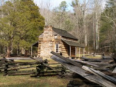 | William Thompson House | building | 1976 | 76001763 |
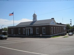 | US Post Office | building | 1988 | 88001577 |
Every wildfire the federal occurrence database records inside this county: 644 of them, burning about 3,496 acres. 4 started naturally and 138 were recorded as arson. Each settlement page carries the fires within five miles of it.
| Reported cause | Fires |
|---|---|
| Debris and open burning | 290 |
| Arson/incendiarism | 138 |
| Equipment and vehicle use | 69 |
| Missing data/not specified/undetermined | 65 |
| Railroad operations and maintenance | 16 |
| Other causes | 16 |
| Power generation/transmission/distribution | 14 |
| Smoking | 12 |
| Recreation and ceremony | 11 |
| Misuse of fire by a minor | 7 |
| Natural | 4 |
| Fireworks | 2 |
The five largest, by the area the report gives. None of them was recorded as arson.
| Date | Cause | Size | Reported by | Name on the report |
|---|---|---|---|---|
| 16 April 2006 | Natural | 200 acres | Tennessee Division of Forestry | not named |
| 9 April 2001 | Debris and open burning | 110 acres | Tennessee Division of Forestry | not named |
| 28 March 2000 | Missing data/not specified/undetermined | 100 acres | Tennessee Division of Forestry | not named |
| 19 February 2007 | Equipment and vehicle use | 93 acres | Tennessee Division of Forestry | NELSON FIRE |
| 5 April 2005 | Debris and open burning | 75 acres | Tennessee Division of Forestry | not named |
| 21 April 2002 | Recreation and ceremony | 71 acres | Tennessee Division of Forestry | not named |
| 22 March 2011 | Debris and open burning | 70 acres | Tennessee Division of Forestry | FRENCH |
| 5 April 2000 | Equipment and vehicle use | 60 acres | Tennessee Division of Forestry | not named |
Every settlement page carries the fires within five miles of it - see the settlement index below.
The NOAA Storm Events Database holds 287 reports for this county, causing 2 deaths, 7 injuries and about $19,369,700 in recorded property damage. Each settlement page carries the reports that name it.
| Kind of event | Reports |
|---|---|
| Thunderstorm Wind | 148 |
| Hail | 60 |
| Flash Flood | 48 |
| Tornado | 25 |
| Lightning | 2 |
| Flood | 2 |
| Heavy Rain | 2 |
The most serious of them, by death, then injury, then recorded damage. The accounts are quoted exactly as the forecast office filed them.
| When | Event | Place named | Harm | What the report says |
|---|---|---|---|---|
| January 1999 | Tornado (F3) | Camden | 1 killed, 5 hurt, $1,000,000 | This tornado resulted in the only fatality in Middle Tennessee from the severe weather outbreak of January 22,1999. The tornado killed a 50 year old woman who left her shelter in a brick ranch home located on Cedar Grove Road. She went outside to get her dogs inside her home, and that's when the tornado struck and killed her. Her husband remained inside the home and survived. There were 5 injuries from the tornado. A 1600 square foot frame home was moved 10 to 12 feet from its foundation. 12 homes were destroyed, 33 homes sustained damage and 5 businesses were damaged. Power lines and trees were blown down. The winds picked up a 7500 pound Cadillac, and hurled its engine 300-400 yards into a field. The chassis, its empty metal skin, was hurled even further. |
| March 2020 | Tornado (EF2) | Liberty | 1 killed, 2 hurt, $1,000,000 | The tornado started in Benton County northwest of Camden and caused a substantial amount of tree damage along the path the extended into the Tennessee River. Several homes and mobile homes were damaged along the path in Benton County. The most damage, in Benton County, was in the Ballard Road area. Peak winds were estimated around 125 mph. The tornado then moved across the Tennessee River and into Humphreys County. |
| February 2008 | Tornado (EF2) | Faxon | $10,000,000 | The tornado came out of northern Benton County and caused damage in Houston County. Trees were uprooted and snapped, and homes were damaged along Highway 147 from the Tennessee River to just west-northwest of McKinnon. There were 20 power poles down on Danville Rd. Worst damage was from Big Sandy to Faxon to Grannys Branch.||Fourteen homes were destroyed, and one other had major damage. About half of these homes were mobile homes. |
| March 1991 | Tornado (F2) | not stated | $2,500,000 | no account filed |
| July 2021 | Thunderstorm Wind | Mt Moriah | $1,000,000 | Straight-line winds caused significant damage to a marina on the Tennessee River southeast of Camden. |
| April 2009 | Tornado (EF1) | Way | $500,000 | Tornado touchdown about 6 miles northeast of Camden at 1041 A.M. CDT. A newspaper reported that the damage began at the Prospect Church and Cemetery, damaging the trim of the church and uprooting trees in the cemetery. It traveled northeast and ended at the Tennessee River at about 1048 A.M. CDT. Damage width was 75 yards wide. Much of the damage was along and near Grapevine and Harmon Dock Roads. Many hundreds of large hardwoood trees and pine trees were snapped or uprooted along the 4 mile damage path. Twelve homes suffered roof and structural damage and several outbuildings, including two barns, were destroyed, two mobile homes were damaged, and at least two cars were damaged per NWS Storm Survey and newspaper reports. Based on this damage, maximum estimated winds at 100 mph which corresponds to and EF-1 Tornado.||Also...one trailor was destroyed on Harmon Creek Road. Numerous trees were reported down in northern portions of the county. |
| November 2005 | Tornado (F2) | Camden | $400,000 | Home destroyed. Roof was gone and walls left standing on a home on French Store Rd. |
| May 2010 | Flood | Big Sandy | $300,000 | Numerous homes, numerous businesses, numerous non comercial buildings, along with several county, state, and federal roads across the county received damage due to the flood. |
| June 2004 | Thunderstorm Wind | Camden | $278,000 | Numerous trees and power lines were blown down. 3 homes had damage because trees fell on them. A 75-foot oak tree, whcih was probably more than 100 years old, fell into another tree, and they both fell on a carport and on a 1995 Ford Aerostar van. The hardest hit areas was in northeast Camden on Wren Avenue, Rowsey Street, and Flatwoods Road. A 500 foot TV tower belonging to Charter Cable fell to the ground. The tower will not be erected, and the metal will be sold for scrap. Dollar damage estimate was from Benton County EMA director. |
| April 2011 | Thunderstorm Wind | Lipe | $250,000 | Damage in Benton county was the result of an unusually intense microburst with estimated wind speeds of 110 miles an hour. Damage occurred along a 15-mile path that was up to 1 mile wide. There were thousands of trees snapped or uprooted. There was also roof damage to many homes. A couple of barns were barns destroyed. |
| April 2006 | Tornado (F2) | Camden | $250,000 | One home was destroyed, and 15 other homes and businesses had major damage. One home lost its entire roof on Conley Branch Rd. Other homes had roof damage. Numerous large trees were snapped, uprooted or blown down. |
| October 2019 | Thunderstorm Wind | Holladay | $200,000 | Seven tractor trailer trucks were blown over on the I-40 bridge over the Tennessee River. In addition, numerous trees and power lines were knocked down across the county. Several homes and a few structures around the county were damaged. |
| June 2014 | Flash Flood | Holladay | $100,000 | Three to four inches of rain fell across Benton County, producing widespread flash flooding. Pineview Road was completely washed out. The bridge on Kelly Road was covered with two feet of water while a culvert was washed out on Rowland Road. |
| July 1997 | Thunderstorm Wind | Camden | $100,000 | Local law enforcement reported 2 or 3 trees were blown down on an electrical transformer and one tree fell on a house. |
| March 1997 | Flash Flood | Camden | $80,000 | 4 roads were closed or washed away due to high water. |
| May 2021 | Tornado (EF0) | Lick Creek | $75,000 | A weak tornado uprooted trees and damaged a few outbuildings. A few homes and vehicles were damaged from trees falling on them. Peak winds were estimated at 80 mph. |
| July 1996 | Thunderstorm Wind | Camden | $75,000 | no account filed |
| June 2019 | Thunderstorm Wind | Lipe | $50,000 | Multiple trees down and power outages across the city of Camden and in Benton County. |
| June 2016 | Thunderstorm Wind | Way | $50,000 | Trees and power lines down between Camden and Eva. |
| August 2009 | Thunderstorm Wind | Camden | $50,000 | Trees were reported down countywide, especially in the Camden area. |
| July 2009 | Flash Flood | Mt Moriah | $50,000 | Several areas across Southern Benton County were flooded. Water washed away the road at the intersection of Camp Mack Morris and Birdsong Road. Road crews worked through the night and into the morning hours of Friday, July 17th getting several of the roads back open. It is estimated that southern areas received up to 9 inches of rain. |
| April 2006 | Tornado (F0) | Big Sandy | $50,000 | Homes loss shingles at the Cedar Lakes Estate along with trees being snapped, uprooted and blown down. |
| November 2005 | Tornado (F1) | Camden | $50,000 | Home damaged. Part of roof was gone. This storm complex came from Carroll County. This tornado touched done again in Benton County. |
| September 2002 | Flash Flood | Countywide | $50,000 | Sheriff's office said 30 roads had to be closed due to high water in the county. Roads affected were mainly between Camden and Big Sandy. A woman was trapped in her car by high water and had to be rescued by boat just north of Camden. She was not hurt. Schools were closed on Friday, Sep. 27 because of water problems on the roads. TDOT stated that a wooden bridge collapsed in the Big Sandy area on Pt. Mason Rd. It was replaced with 3 culverts. Also, a 20 foot section of road on Spring Drive near Camden had to be replaced with gravel. These rains were from the remnants of "Isidore". Some areas in Benton county received as much as 7 inches of rain from this storm. |
| February 1997 | Thunderstorm Wind | Camden | $50,000 | no account filed |
| February 2018 | Thunderstorm Wind | Wyly | $40,000 | Several trees and a few power poles down causing power outages across the county. |
| March 2023 | Thunderstorm Wind | Camden | $25,000 | Straight-line winds uprooted and snapped trees. A roof was blown off. |
| August 2023 | Thunderstorm Wind | Lipe | $25,000 | Multiple trees and powerlines were knocked down across Benton County. Some roads were blocked by fallen trees. |
| August 2017 | Flash Flood | Rockport | $25,000 | Hatley Road flooded. Service truck stuck in flood. Culvert damaged. |
| March 2016 | Tornado (EF1) | Gismonda | $25,000 | A tornado touched down several miles south of Camden in Benton County. The tornado track was intermittent, with two primary areas of damage. The first area was south of the Old Natchez Trace Trail, from Douglas Drive to Douglas Lane. Numerous trees were uprooted, with the tree fall pattern suggesting a circulation. The second area of damage was between Highway 641 and Old Highway 69. The tornado damaged the roof of a barn. Nearby, the tornado blew in the large door of a metal workshop and removed most of the workshop's door. Portions of the roof landed across old Highway 69. The estimated peak wind was 90 mph. |
| February 2011 | Thunderstorm Wind | Way | $25,000 | Benton County Sheriffs Office reported several locations in central Benton County where trees had been blown down. |
| April 2011 | Thunderstorm Wind | Gismonda | $25,000 | Trees were reported downed across the southern part of the county. Power outages were also reported across the county. |
| July 2009 | Flash Flood | Holladay | $25,000 | Numerous secondary roads were closed and several roads were washed out across|southern portions of the county. |
| May 2008 | Thunderstorm Wind | Holladay | $25,000 | Benton County EMA said a tree fell on a trailer home at 7020 Highway 192 near Holladay. Trees were down along Sorghum Road toward U.S. Highway 641. |
| May 1971 | Tornado (F4) | not stated | $25,000 | no account filed |
| February 1952 | Tornado (F2) | not stated | $25,000 | no account filed |
| April 2026 | Thunderstorm Wind | Gismonda | $20,000 | Numerous trees and a few power lines were knocked down across southern Benton County. |
| May 2025 | Thunderstorm Wind | Big Sandy | $20,000 | Power lines and trees down on Bain Road. |
| March 2023 | Thunderstorm Wind | Liberty | $20,000 | Straight-line winds uprooted trees along Hargis Road and Liberty Road. A home on Liberty Road suffered roof damage. |
| July 2023 | Thunderstorm Wind | Holladay | $20,000 | Numerous trees were knocked down from Holladay to Camden. A few roadways were blocked. |
| December 2021 | Tornado (EF0) | Mc Illwain | $20,000 | The tornado crossed into Benton County from Decatur County. Tree damage was noted along the path. The tornado lifted near Redbud Lane. Peak winds were estimated to be 80 mph in Benton County. |
| November 2018 | Thunderstorm Wind | Liberty | $20,000 | Several tops of trees down on Highway 69 between Camden and Big Sandy. |
| March 2017 | Thunderstorm Wind | Big Sandy | $20,000 | Large tree fell on a car. No injuries. |
| May 1996 | Thunderstorm Wind | Camden | $20,000 | no account filed |
| March 1996 | Thunderstorm Wind | Faxon | $20,000 | no account filed |
| April 2026 | Thunderstorm Wind | Liberty | $15,000 | Several trees and powerlines downed across Benton County. |
| March 2023 | Tornado (EF0) | Liberty | $15,000 | A tornado briefly touched down along an elevated area and led to the collapse of walls and the removal of much of the roof of a metal outbuilding along Sawmill Rd. The tornado also damaged branches on a couple of trees near the outbuilding, lifted briefly, and then downed more limbs along Cedar Grove Church Road. While the damage path was short-lived in duration, it was determined to be tornadic based on the convergent damage pattern and vertical lift of roof panels into trees behind the outbuilding. A special goes out to Benton County Emergency Management for their assistance in locating damage during the survey. Peak winds were estimated at 85 mph. |
| July 2023 | Thunderstorm Wind | Wyly | $15,000 | Multiple trees were knocked down from the Benton County line into Camden. A transformer was also struck by lightning. |
| July 2012 | Thunderstorm Wind | Rockport | $15,000 | Several trees were blown down between Camden and Interstate 40. |
| September 2012 | Thunderstorm Wind | Gismonda | $15,000 | Several trees and power lines were downed along James Walker Road. |
| August 2010 | Thunderstorm Wind | Crossroad | $15,000 | Several trees were reported down at the intersection of Norwood Road and Divider and Natchez Trace Road. These trees were large enough that the Benton County Highway Department was called out and chainsaws were needed to remove them from off of the road. |
| May 2025 | Thunderstorm Wind | Big Sandy | $10,000 | Trees down along Danville Road. |
| April 2025 | Thunderstorm Wind | Wyly | $10,000 | A downed tree landed on a powerline at Hwy 641 and Big Sandy River Rd. |
| June 2024 | Thunderstorm Wind | Big Sandy | $10,000 | Several trees were knocked down blocking roads in Big Sandy. |
| March 2022 | Thunderstorm Wind | Mc Illwain | $10,000 | Powerlines down on Highway 69A, trees down on Highway 192 and Lick Creek Road. |
| June 2021 | Thunderstorm Wind | Big Sandy | $10,000 | A large tree fell on a house. |
| February 2018 | Flood | Eva | $10,000 | Heavy rain resulted in the flooding of some secondary roads. A few culverts were damaged. |
| March 2016 | Flash Flood | Lick Creek | $10,000 | Heavy rain resulted in flash flooding across Benton County. Valentine Branch Road in Big Sandy was closed due to a washed out culvert. Old Highway 70 was closed along with Fern Street in Camden. Liberty Church Road was covered with water. Washington Street was also closed. |
| August 2016 | Thunderstorm Wind | Liberty | $10,000 | Multiple trees down on Flatwoods Road and tree down on a power line on Reese Road in Benton County. Report of tree on Reese Road came in from Law Enforcement. |
| May 2012 | Flash Flood | Camden | $10,000 | Several roads flooded northeast of Camden including Ebenezer Road, Joe Corbitt Road, Flatwoods Road, and Cuff Road. Within this area, CoCoRaHS reports measured 5.75 inches of rainfall between 4:45 am and 8:22 am. |
The Survey's mineral resources record lists 108 workings inside this county. 46 still produce and 62 are closed or unrecorded. Each settlement page carries the workings within five miles of it.
| Commodity | Workings |
|---|---|
| Silica | 53 |
| Sand and Gravel, Construction | 41 |
| Clay | 7 |
| Zirconium, Titanium | 2 |
| Stone, Crushed/Broken | 2 |
| Titanium, Metal, Zirconium, REE, Thorium | 1 |
| Stone, Crushed/Broken, Limestone, General | 1 |
| Titanium, Metal | 1 |
| Kyanite, Zirconium, Thorium | 1 |
| REE | 1 |
| Fullers Earth | 1 |
| Iron | 1 |
The least common of them first, because a county's hundredth gravel pit says nothing its first ten did not.
| Where | Site | Commodity | Status | Recorded |
|---|---|---|---|---|
| Benton County Plant | Stone, Crushed/Broken, Limestone, General | Producer | Limestone | |
| Benton Cut | Fullers Earth, Clay | Past Producer | ||
| Kerr-Mcgee Deposit | Titanium, Metal, Zirconium, REE, Thorium | Prospect | 1956 | |
| Manleyville-Camden Placer | Titanium, Metal, Kyanite, Zirconium, Thorium | Producer | Ilmenite, Kyanite, Monazite, Rutile, Zircon | |
| Scarborough Prospect | Iron | Past Producer | ||
| Silica Mine | Silica, Zirconium, Titanium, REE | Producer | Surface | |
| Benton County Quarry | Stone, Crushed/Broken | Producer | ||
| Kerr-Mcgee | Zirconium, Titanium | Prospect | 1956 | |
| Limestone Pit | Stone, Crushed/Broken | Producer | ||
| Center Hill School Prospect | Clay | Prospect | ||
| Holladay Prospect | Clay | Occurrence | ||
| North Holladay Prospect | Clay | Occurrence | ||
| South Camden Prospect | Clay | Occurrence | ||
| Southeast Camden Prospect | Clay | Prospect | ||
| Sugar Tree Prospect | Clay | Occurrence | ||
| #1 Herndon Pit | Sand and Gravel, Construction | Producer | ||
| #12 Sullins Pit | Sand and Gravel, Construction | Producer | Unconsolidated Sediments | |
| #3 Mc Lynn Pit | Sand and Gravel, Construction | Producer | Unconsolidated Sediments | |
| #4 Cole Pit | Sand and Gravel, Construction | Producer | Unconsolidated Sediments | |
| Bevins-Davis Pit | Sand and Gravel, Construction | Producer | ||
| Bevins-Davis Pit | Sand and Gravel, Construction | Past Producer | Sedimentary | |
| C. N. Armour Construction Co. #1 Marrs Pit | Sand and Gravel, Construction | Producer | ||
| C. N. Armour Construction Pit | Sand and Gravel, Construction | Past Producer | ||
| Camden Mine | Sand and Gravel, Construction | Producer | ||
| Camden Mine | Sand and Gravel, Construction | Producer | ||
| Camden Pit | Sand and Gravel, Construction | Past Producer | Sedimentary | |
| Camden Pit | Sand and Gravel, Construction | Producer | ||
| Flowers Mine | Sand and Gravel, Construction | Past Producer | ||
| Malin Pit | Sand and Gravel, Construction | Past Producer | Sedimentary | |
| Memphis Stone & Gravel Co., Inc. | Sand and Gravel, Construction | Producer | ||
| Molding Mill | Sand and Gravel, Construction | Past Producer | ||
| Molding Mine | Sand and Gravel, Construction | Producer | ||
| No. 2 Herndon Pit | Sand and Gravel, Construction | Past Producer | ||
| No. 3 Mclynn Pit | Sand and Gravel, Construction | Past Producer | ||
| No. 4 Cole Pit | Sand and Gravel, Construction | Past Producer | ||
| Number 1 Herndon Pit | Sand and Gravel, Construction | Past Producer | Sedimentary | |
| Number 1 Herndon Pit | Sand and Gravel, Construction | Past Producer | ||
| Number 1 Marrs Pit | Sand and Gravel, Construction | Past Producer | Sedimentary | |
| Number 1 Marrs Pit | Sand and Gravel, Construction | Past Producer | ||
| Number 12 Sullins Pit | Sand and Gravel, Construction | Past Producer | Sedimentary | |
| Number 3 Mclynn Pit | Sand and Gravel, Construction | Past Producer | Sedimentary | |
| Number 3 Mclynn Pit | Sand and Gravel, Construction | Producer | ||
| Number 4 Cole Pit | Sand and Gravel, Construction | Past Producer | Sedimentary | |
| Number 5 Bond Pit | Sand and Gravel, Construction | Past Producer | Sedimentary | |
| Number 7 Sullins Pit | Sand and Gravel, Construction | Past Producer | Sedimentary | |
| Number 8 Bobitt Pit | Sand and Gravel, Construction | Past Producer | Sedimentary | |
| Porter Warner Pit | Sand and Gravel, Construction | Past Producer | Sedimentary | |
| Sullins Pit #1 | Sand and Gravel, Construction | Producer | Unconsolidated Sediments | |
| Sullins Pit #2 | Sand and Gravel, Construction | Producer | Unconsolidated Sediments | |
| Sullins Pit Number 1 | Sand and Gravel, Construction | Past Producer | Sedimentary | |
| Sullins Pit Number 2 | Sand and Gravel, Construction | Past Producer | Sedimentary | |
| Tva Pit | Sand and Gravel, Construction | Past Producer | Sedimentary | |
| Tva Pit | Sand and Gravel, Construction | Producer | ||
| Tva Pit | Sand and Gravel, Construction | Producer | ||
| W C Branch Pit | Sand and Gravel, Construction | Producer | ||
| Wills Pit | Sand and Gravel, Construction | Past Producer | Sedimentary | |
| #12 Sullins Pit | Silica | Producer | Unconsolidated Sediments | |
| #5 Bond Pit | Silica | Producer | Unconsolidated Sediments | |
| #7 Sullins Pit | Silica | Producer | Unconsolidated Sediments | |
| #8 Bobitt Pit | Silica | Producer | Unconsolidated Sediments | |
| Bell Pit | Silica | Past Producer | Unconsolidated Sediments | |
| Bell Pit | Silica | Past Producer | ||
| Bonds Pit | Silica | Producer | Unconsolidated Sediments | |
| Bonds Pit | Silica | Past Producer | ||
| Cole Pit | Silica | Producer | Unconsolidated Sediments | |
| Dunning Pit | Silica | Producer | Unconsolidated Sediments | |
| Dunning Pit | Silica | Past Producer | ||
| Furr Pit #6 | Silica | Past Producer | Unconsolidated Sediments | |
| Furr Pit #7 | Silica | Producer | Unconsolidated Sediments | |
| Hardy and Nunnley Pit | Silica | Producer | Unconsolidated Sediments | |
| Hardy and Nunnley Pit | Silica | Past Producer | ||
| Higdon & Cole Pit | Silica | Producer | Unconsolidated Sediments | |
| Hollingsworth Pit | Silica | Producer | Unconsolidated Sediments | |
| Hollingsworth Pit | Silica | Past Producer | Unconsolidated Sediments | |
| Hollingsworth Pit | Silica | Past Producer | ||
| Jordan Pit | Silica | Producer | Unconsolidated Sediments | |
| Jordan Pit | Silica | Past Producer | ||
| Kee Pit | Silica | Producer | Unconsolidated Sediments | |
| Kee Pit | Silica | Past Producer | ||
| Kee and Furr Pit | Silica | Producer | Unconsolidated Sediments | |
| Kee and Furr Pit | Silica | Past Producer | ||
| Malin Pit | Silica | Producer | Unconsolidated Sediments | |
| Malin Pit | Silica | Past Producer | ||
| Mill Number 3 | Silica | Plant | ||
| Number 12 Sullins Pit | Silica | Past Producer | ||
| Number 4 Cole Pit | Silica | Past Producer | ||
| Number 7 Sullins Pit | Silica | Past Producer | ||
| Number 8 Bobitt Pit | Silica | Past Producer | ||
| Porter Warner Pit | Silica | Producer | Unconsolidated Sediments | |
| Porter Warner Pit | Silica | Past Producer | ||
| Ragsdale Pit | Silica | Producer | Unconsolidated Sediments | |
| Ragsdale Pit | Silica | Past Producer | ||
| Smith Pit | Silica | Producer | Unconsolidated Sediments | |
| Smith Pit | Silica | Past Producer | ||
| Stigall Pit | Silica | Producer | Unconsolidated Sediments | |
| Stigall Pit | Silica | Past Producer | ||
| Sullins Pit Number 1 | Silica | Past Producer | ||
| Sullins Pit Number 2 | Silica | Past Producer | ||
| Sullins Sand Company, Inc. | Silica | Past Producer | ||
| Wills Pit | Silica | Producer | Unconsolidated Sediments | |
| Wills Pit | Silica | Past Producer | ||
| Wright Pit #3 | Silica | Producer | Unconsolidated Sediments | |
| Wright Pit #4 | Silica | Producer | Unconsolidated Sediments | |
| Wright Pit Number 3 | Silica | Past Producer | ||
| Wright Pit Number 4 | Silica | Past Producer | ||
| Wyatt Pit | Silica | Past Producer | Unconsolidated Sediments | |
| Wyatt Pit | Silica | Producer | Unconsolidated Sediments | |
| Wyatt Pit | Silica | Past Producer |
Named settlements recorded in the Geographic Names Information System, each with the topographic sheets covering it. Villages, hamlets and abandoned places alike. Each is shown with the nearest named watercourse or landform and the survey quadrangle it falls on.
District 4 · 38333 · On Middle Fork Harmon Creek · Johnsonville quadrangle
9 sheets, 1936 to 1985
District 4 · 38333 · On Sulphur Creek · Harmon Creek quadrangle
8 sheets, 1936 to 1985
No longer a settlement
District 6 · 38221 · On South Fork Crooked Creek · Poplar Creek quadrangle
11 sheets, 1936 to 1986
District 1 · 38341 · On West Fork Birdsong Creek · Holladay quadrangle
9 sheets, 1936 to 1986
District 6 · 38221 · On Valentine Branch · Poplar Creek quadrangle
11 sheets, 1936 to 1986
District 1 · 38320 · On Badger Creek · Rockport quadrangle
10 sheets, 1936 to 1986
The vanished settlements of Benton County: the places named above that are no longer on the map.