 Block
From the record
10 National Register listings published here, 1 of them a National Historic Landmark.
Sources: the National Register database, National Park Service
52 topographic sheets cover 68 settlements here, and 10 properties are on the National Register of Historic Places.
10 National Register listings published here, 1 of them a National Historic Landmark.
Sources: the National Register database, National Park Service
Every property in this county listed on the National Register of Historic Places, with the year it was listed and the federal nomination document.
| Photograph | Property | Type | Listed | Reference |
|---|---|---|---|---|
| Arch Bridge | structure | 2020 | 100005375 | |
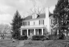 | Cherry Mansion | building | 1977 | 77001274 |
| James Graham House | building | 1991 | 91001594 | |
| Pickwick Landing Hydroelectric Project | district | 2017 | 100001467 | |
| Savannah Historic District | district | 1980 | 80003832 | |
| Savannah Historic District (Boundary Increase II) | district | 2009 | 09000534 | |
| Savannah Historic District (Boundary Increase) | building | 1993 | 93001153 | |
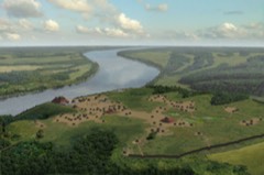 | Shiloh Indian Mounds Site | district | 1979 | 79000279 |
 | Shiloh National Military Park | district | 1966 | 66000074 |
 | Meady White House | building | 1993 | 93000586 |
Every wildfire the federal occurrence database records inside this county: 770 of them, burning about 8,545 acres. 12 started naturally and 292 were recorded as arson. Each settlement page carries the fires within five miles of it.
| Reported cause | Fires |
|---|---|
| Debris and open burning | 311 |
| Arson/incendiarism | 292 |
| Missing data/not specified/undetermined | 75 |
| Equipment and vehicle use | 37 |
| Natural | 12 |
| Smoking | 9 |
| Power generation/transmission/distribution | 8 |
| Other causes | 8 |
| Recreation and ceremony | 6 |
| Fireworks | 6 |
| Misuse of fire by a minor | 6 |
The five largest, by the area the report gives. Two of them were set deliberately.
| Date | Cause | Size | Reported by | Name on the report |
|---|---|---|---|---|
| 21 February 2000 | Arson/incendiarism | 900 acres | Tennessee Division of Forestry | not named |
| 16 April 2008 | Missing data/not specified/undetermined | 390 acres | Tennessee Division of Forestry | GOBBLER BRANCH ROAD |
| 16 April 2008 | Debris and open burning | 235 acres | Tennessee Division of Forestry | not named |
| 12 March 2014 | Missing data/not specified/undetermined | 172 acres | Natchez Trace Parkway | SHIL-N SPAIN BRANCH |
| 27 January 2017 | Missing data/not specified/undetermined | 162 acres | Natchez Trace Parkway | NORTHERN SPAIN - SHIL |
| 1 September 1999 | Arson/incendiarism | 160 acres | Tennessee Division of Forestry | not named |
| 28 January 2017 | Missing data/not specified/undetermined | 144 acres | Natchez Trace Parkway | MIDDLE BRANCH - SHIL |
| 31 January 2017 | Debris and open burning | 140 acres | Tennessee Division of Forestry | AFM |
Every settlement page carries the fires within five miles of it - see the settlement index below.
The NOAA Storm Events Database holds 256 reports for this county, causing 4 deaths, 40 injuries and about $35,639,730 in recorded property damage. Each settlement page carries the reports that name it.
| Kind of event | Reports |
|---|---|
| Thunderstorm Wind | 118 |
| Hail | 82 |
| Flash Flood | 29 |
| Tornado | 21 |
| Flood | 4 |
| Lightning | 2 |
The most serious of them, by death, then injury, then recorded damage. The accounts are quoted exactly as the forecast office filed them.
| When | Event | Place named | Harm | What the report says |
|---|---|---|---|---|
| February 2008 | Tornado (EF4) | Box Elder | 3 killed, 5 hurt, $17,600,000 | The initial tornado touchdown occurred west of the Tennessee River near the intersection of Coffee Landing Road and Towboat Lane about 740 pm CST. The tornado then quickly raced northeast causing extensive damage to homes and trees just east of the Tennessee River in the Oak Grove, Cerro Gordo and Swift Communities. The tornado destroyed 59 houses, 11 mobile homes, 11 public buildings, a vacant store and 11 farm buildings. Another 117 structures received varying degrees of damage. Four of the 11 public buildings belonged to the Sharon Baptist Church. The church lost its sanctuary, preschool, academy and student center, off Cravens Road in the Oak Grove area. Two of the five injuries occurred at the church while two more injuries occurred in homes in the Oak Grove area. All three deaths occurred in mobile homes. Two of the deaths occurred in the Cerro Gordo area while the third fatality occurred in northeast Hardin County in the vicinity of Nance Bend Road and Highway 128. The tornado continued northeast before lifting near the intersection of Highway 114 and Highway 128 around 757 pm CST. The path length was about 16 miles and the maximum width was one half mile. The highest estimated winds were around 170 mph. Utility restoration costs were estimated at around $200,000. |
| July 2018 | Thunderstorm Wind | Pickwick Lake | 1 killed, $20,000 | Tree fell on car initially injuring a woman who later passed away at the hospital. |
| May 2004 | Thunderstorm Wind | Savannah | 22 hurt, $100,000 | Twenty five camper trailers and three campsites were destroyed injuring several people. Some of the camper trailers were blown into the Tennessee River. Several trees were knocked down. |
| April 1954 | Tornado (F2) | not stated | 4 hurt, $250,000 | no account filed |
| March 1964 | Tornado (F3) | not stated | 3 hurt, $2,500,000 | no account filed |
| April 2011 | Tornado (EF2) | Counce | 2 hurt, $1,800,000 | A tornado touched down south of Counce and moved northeast toward Pickwick Lake. The tornado lifted just before reaching Pickwick Lake. At least 15 homes sustained moderate to major damage. A number of other homes sustained minor damage. Two mobile homes were destroyed. A pizza restaurant and a hardware store were also destroyed. Numerous trees and power lines were also knocked down. Two minor injuries occurred from the tornado. |
| May 2010 | Tornado (EF2) | Morris Chapel | 2 hurt, $100,000 | A tornado tracked northeast into Hardin County from McNairy County and hit the town of Milledgeville. One house sustained major damage while another sustained roof damage. Minor damage occurred to a shed. Several trees were knocked down in the area. Two injuries occurred from the tornado. This storm went on to produce a tornado in Henderson and Decatur Counties. |
| May 2006 | Lightning | Pickwick Dam | 1 hurt, $10 | One individual near the TVA Dam was struck by lightning. The individual complained of numbness in both arms and was unable to swallow. The individual was transported to a hospital. |
| May 2021 | Thunderstorm Wind | Savannah | 1 hurt | Straight-line winds knocked down 30-40 trees. Several trees fell on houses while several power lines were knocked down as well. |
| March 2023 | Tornado (EF3) | Box Elder | $4,000,000 | This tornado weakened as it moved from McNairy into Hardin County, with damage to homes and trees along Highway 69, Old Union Road, Harris Road, and Glendale Road near Hookers Bend. One area of more intense damage was surveyed near Chalk Bluff along Glendale Road where a manufactured home was completely destroyed and an area of trees was slightly debarked. The tornado then approached New Harmony, crossing the bends in the Tennessee River three times. Numerous homes were damaged along Emerald Lane and in the area of Flat Bluff near Becky Road and Lion Lane. Additional damage was noted in the Crossroads area along Clifton and Hardin Creek Roads as the tornado moved into Wayne County. In total, nearly 150 structures were damaged in Hardin County between this tornado and the EF-2 that occurred a couple of hours earlier, 42 of which were total losses. Peak winds in Hardin County from this tornado were estimated at 145 mph. |
| October 2019 | Thunderstorm Wind | Damon | $2,600,000 | Numerous trees and power lines were knocked down in Hardin County. Numerous houses and structures around the county were damaged. |
| May 2010 | Flash Flood | Swift | $2,000,000 | Heavy rain produced widespread flash flooding across Hardin County. One hundred roads were damaged as a result. Several water rescues occurred as a result of the flooding. Forty homes and twenty six businesses reported at least minor damage. |
| September 2009 | Flash Flood | Savannah | $1,250,000 | Numerous roads were closed due to flash flooding. Sixteen homes were damaged by the flash flood. At least one person was rescued in the Burnt Church community because of the flash flooding. |
| August 2010 | Flash Flood | Eureka | $1,200,000 | Heavy rain produced widespread flash flooding in Hardin County. Several roads in Savannah were closed as a result including Highway 64 which was covered by at least six inches of water. At least 5 homes along Hwy 64 in Olive Hill sustained flood damage. Numerous roads and bridges sustained damage from the flooding. One man was rescued from his vehicle after being trapped from flood waters on Lonesome Pine Road. One other motorist had to be rescued as well. Roads were also closed northeast of Savannah where water was as high as two feet on some roads. |
| May 1999 | Thunderstorm Wind | Crump | $250,000 | Over fifty homes and buildings were damaged or destroyed. Several trees and power lines were also knocked down. |
| January 1978 | Tornado (F1) | not stated | $250,000 | no account filed |
| February 1958 | Tornado (F3) | not stated | $250,000 | no account filed |
| May 2011 | Thunderstorm Wind | Walnut Grove | $202,000 | Straight line winds knocked down trees and power lines across much of Hardin County. A house and two vehicles were damaged by fallen trees in the Shiloh area. Across the county a total of five homes suffered minor damage and a mobile home had major damage. One farm building was also destroyed. Areas most impacted besides Shiloh included Bruton Branch, Pickwick, Counce and Walnut Grove. |
| March 2023 | Tornado (EF2) | Morris Chapel | $150,000 | This tornado moved into Hardin County from McNairy County. The tornado caused EF-2 damage at the Morris Chapel Methodist Church, with significant roof damage and the collapse of an exterior wall. The tornado dissipated in a field just south of White Oak Creek Canal a few miles to the northeast around 9:51 PM CDT. Peak winds in Hardin County from this tornado were estimated at 115 mph. |
| August 2004 | Flash Flood | Burnt Church | $140,000 | Three homes were evacuated due to rising flood waters. A couple of roads and bridges were washed out as well. The Hardin County Nursery was destroyed including all the plants. |
| October 2010 | Thunderstorm Wind | Savannah | $91,000 | Straight line winds produced widespread damage for a 3 mile swath that was about 200 yards wide in Savannah. Numerous trees were knocked down, some were knocked down onto homes. Four homes sustained moderate damage with 8 homes sustaining minor damage. Several power lines were blown down as well causing power outages. |
| April 2025 | Tornado (EF2) | Right | $75,000 | This tornado crossed from McNairy County into Hardin County. Damage was generally confined to trees where the tornado crossed Highway 69, Coffee Landing Road, and Marshall Drive. The last damage was noted northeast of Shotwell Lane, with the tornado lifting before reaching Sulphur Wells Road. Estimated peak winds were around 120 mph in Hardin County. |
| July 2023 | Thunderstorm Wind | Lowryville | $25,000 | Trees were knocked onto a house. |
| July 2023 | Thunderstorm Wind | Eureka | $25,000 | Trees were knocked down across Hardin County with widespread power outages. |
| March 2021 | Flash Flood | Burnt Church | $25,000 | A bridge located on Highway 203 near the Burnt Church Community Center was undermined by flooding. |
| March 2021 | Lightning | Pickwick Dam | $25,000 | Three homes were struck by lightning within a one-hour period in the Bruton Branch and Pickwick areas. Two homes had a fire in the wall and received minor damage and the third smelled of smoke. |
| March 2016 | Tornado (EF1) | Counce | $25,000 | A weak tornado caused mainly roof damage to a home and damage to a recreational vehicle. Trees were knocked down along with a power pole. Peak estimated wind was 90 mph. |
| February 2008 | Hail | Morris Chapel | $25,000 | Tennis ball size hail fell in the North Crump and Morris Chapel area. Several homes and automobiles were damaged. |
| March 2006 | Thunderstorm Wind | Savannah | $25,000 | A building was destroyed at the Savannah Airport Industrial Park. Some trees were also blown down. |
| July 2003 | Thunderstorm Wind | Countywide | $25,000 | Numerous trees and power lines were knocked down across the county. |
| September 1999 | Thunderstorm Wind | Savannah | $25,000 | A couple of houses lost their roofs. Numerous trees were blown down. |
| April 1998 | Thunderstorm Wind | Savannah | $25,000 | Several homes had their roofs blown off. A few large trees were knocked down. |
| March 1991 | Tornado (F1) | not stated | $25,000 | no account filed |
| May 1976 | Tornado (F3) | not stated | $25,000 | no account filed |
| April 1970 | Tornado (F4) | not stated | $25,000 | no account filed |
| April 2025 | Tornado (EF0) | Walnut Grove | $20,000 | Additional areas of tree damage were noted across the state line into Hardin County, Tennessee. Subsequent damage surveys and supplementary satellite imagery will help determine an accurate endpoint of the tornado after it extended into Tennessee. Estimated peak winds were around 75 mph. |
| February 2016 | Flash Flood | Hinkle | $20,000 | Heavy rain resulting in flash flooding in Northwest Hardin County. A car was swept away on Martin Road at Middleton Creek. The water rescue was successful. |
| January 2002 | Flash Flood | Savannah | $20,000 | One home was flooded. Numerous roads were closed due to flooding. |
| February 2021 | Thunderstorm Wind | Walnut Grove | $15,000 | A large tree fell on a home on Bensontown Drive in Walnut Grove causing significant damage to the roof and a broken window. |
| May 2019 | Thunderstorm Wind | Pickwick Dam | $15,000 | Power outages from downed power lines reported across portions of Hardin County. |
| April 2004 | Thunderstorm Wind | Savannah | $15,000 | Some homes had minor roof damage. Some trees were knocked down. |
| April 2003 | Thunderstorm Wind | Savannah | $15,000 | A medical building had large pieces of its roof blown off. |
| June 2001 | Thunderstorm Wind | Savannah | $15,000 | Numerous trees and power lines were knocked down. |
| April 2006 | Hail | Savannah | $15,000 | no account filed |
| March 2023 | Thunderstorm Wind | Bucktown | $10,000 | The rear flank downdraft of the EF-3 tornado that developed and moved across McNairy County caused extensive roof damage to an outbuilding on Vista River Lane near the Tennessee River. |
| April 2022 | Thunderstorm Wind | Walkertown | $10,000 | Trees were knocked down in Walkertown. |
| September 2020 | Flood | Sibley | $10,000 | Flooding from heavy rains washed out a portion of the 5000 block of Marshall Drive, north of Savannah. |
| April 2018 | Thunderstorm Wind | Maddox | $10,000 | A few utility poles were down along Airport Road southeast of Savannah. |
| August 2017 | Tornado (EF0) | Crump | $10,000 | A weak tornado damaged irrigation equipment near Crump. Peak winds estimated at 60 mph. |
| August 2017 | Tornado (EF0) | Olivehill | $10,000 | A weak tornado touched down near Olive Hill damaging carports, sheds and trees. Peak winds estimated at 75 mph. |
| April 2005 | Thunderstorm Wind | Savannah | $10,000 | One large oak tree was blown down on a house. |
| July 2003 | Thunderstorm Wind | Countywide | $10,000 | Some trees and power lines were blown down across the county. |
| July 2003 | Thunderstorm Wind | Countywide | $10,000 | Many trees and power lines were blown down across the county. |
| April 2003 | Thunderstorm Wind | Savannah | $10,000 | Some roofs were damaged. Several trees were blown down. |
| March 2002 | Flash Flood | Walnut Grove | $10,000 | Several roads were flooded. |
| October 2001 | Thunderstorm Wind | Countywide | $10,000 | Numerous trees were blown down across the county. |
| June 1998 | Thunderstorm Wind | Savannah | $10,000 | Numerous trees were knocked down all over the town of Savannah. |
| December 1996 | Thunderstorm Wind | Savannah | $10,000 | no account filed |
| August 2010 | Thunderstorm Wind | Savannah | $7,000 | Straight line winds knocked down a couple of trees and a pavilion in Savannah. |
| June 2025 | Thunderstorm Wind | Walkertown | $5,000 | A tree fell on a storage building causing damage on Hima Rd. |
The Survey's mineral resources record lists 68 workings inside this county. 12 still produce and 56 are closed or unrecorded. Each settlement page carries the workings within five miles of it.
| Commodity | Workings |
|---|---|
| Iron | 47 |
| Sand and Gravel, Construction | 15 |
| Zinc | 2 |
| Stone, Crushed/Broken | 2 |
| Limestone, General, Stone, Crushed/Broken | 1 |
| Clay | 1 |
The least common of them first, because a county's hundredth gravel pit says nothing its first ten did not.
| Where | Site | Commodity | Status | Recorded |
|---|---|---|---|---|
| North Savannah Prospect | Clay | Prospect | ||
| Savannah Plant #531 | Limestone, General, Stone, Crushed/Broken | Producer | Limestone | |
| Deep Well-Sphalerite Occurrence | Zinc | Occurrence | Sphalerite | |
| Deep Well-Sphalerite Occurrence | Zinc | Occurrence | ||
| Savannah Plant #531 & Quarry | Stone, Crushed/Broken | Producer | ||
| Tennessee Mine | Stone, Crushed/Broken | Producer | ||
| #1 Taylor Pit | Sand and Gravel, Construction | Producer | Unconsolidated Sediments | |
| Crump Landing Plant | Sand and Gravel, Construction | Producer | ||
| Crump Landing Plant Dredge Operation | Sand and Gravel, Construction | Producer | Unconsolidated Sediments | |
| Number 1 Taylor Pit | Sand and Gravel, Construction | Past Producer | Sedimentary | |
| Number 1 Taylor Pit | Sand and Gravel, Construction | Producer | ||
| Roberts Pit | Sand and Gravel, Construction | Producer | Unconsolidated Sediments | |
| Roberts Pit | Sand and Gravel, Construction | Past Producer | Sedimentary | |
| Roberts Pit | Sand and Gravel, Construction | Producer | ||
| Savannah Dredge | Sand and Gravel, Construction | Past Producer | Sedimentary | |
| Savannah Dredge | Sand and Gravel, Construction | Producer | ||
| Savannah Plant Dredge Operation | Sand and Gravel, Construction | Producer | Unconsolidated Sediments | |
| Shiloh Mine | Sand and Gravel, Construction | Producer | ||
| Waldrep Pit | Sand and Gravel, Construction | Past Producer | Unconsolidated Sediments | |
| Waldrep Pit | Sand and Gravel, Construction | Past Producer | ||
| Whitlow Prospect | Sand and Gravel, Construction | Occurrence | ||
| Abel Prospect | Iron | Occurrence | ||
| Bethleham Prospect | Iron | Occurrence | ||
| Bruton Branch Prospect | Iron | Occurrence | ||
| Bumpus Creek Prospect | Iron | Occurrence | ||
| Burnt Church and School Prospect | Iron | Occurrence | ||
| Burnt Stand Prospect | Iron | Occurrence | ||
| Choate Creek Prospect | Iron | Occurrence | ||
| Covey Chapel Prospect | Iron | Occurrence | ||
| Cross Roads Chapel Prospect | Iron | Occurrence | ||
| Dry Creek Road Prospect | Iron | Occurrence | ||
| Duncan's Chapel & School Prospect | Iron | Occurrence | ||
| Florence-Walnut Grove Road Prospect | Iron | Occurrence | ||
| Franks Prospect | Iron | Occurrence | ||
| Gillis Mills Prospect | Iron | Occurrence | ||
| Holland Creek Prospect | Iron | Occurrence | ||
| Horse Creek Prospect | Iron | Occurrence | ||
| Hosey Prospect | Iron | Occurrence | ||
| Irwin Prospect | Iron | Occurrence | ||
| Left Fork Prospect | Iron | Occurrence | ||
| Little Turkey Creek Prospect | Iron | Occurrence | ||
| Lowryville Prospect | Iron | Occurrence | ||
| Morris Chapel Prospect | Iron | Occurrence | ||
| Mount Herman Chapel Prospect | Iron | Occurrence | ||
| Mount View School Prospect | Iron | Occurrence | ||
| Newman Prospect | Iron | Occurrence | ||
| Old Hurricane Church Prospect | Iron | Occurrence | ||
| Olivehall Prospect | Iron | Occurrence | ||
| Petty Branch Prospect | Iron | Occurrence | ||
| Pompey Branch Prospect | Iron | Occurrence | ||
| Reynolds Prospect | Iron | Occurrence | ||
| Ross Prospect | Iron | Occurrence | ||
| Seaton Prospect | Iron | Occurrence | ||
| Shiloh Park Prospect | Iron | Occurrence | ||
| Smith Fork Prospect | Iron | Occurrence | ||
| South Morris Chapel Prospect | Iron | Occurrence | ||
| Tom Irwin Prospect #1 | Iron | Occurrence | ||
| Tom Irwin Prospect #2 | Iron | Occurrence | ||
| Turkey Creek Prospect | Iron | Occurrence | ||
| Union Chapel and School Prospect | Iron | Occurrence | ||
| Unnamed Prospect | Iron | Occurrence | ||
| Unnamed Prospect | Iron | Occurrence | ||
| Unnamed Prospect | Iron | Occurrence | ||
| Unnamed Prospect | Iron | Occurrence | ||
| Unnamed Prospect | Iron | Occurrence | ||
| Unnamed Prospect | Iron | Occurrence | ||
| Unnamed Prospect | Iron | Occurrence | ||
| Watson Prospect | Iron | Occurrence |
Named settlements recorded in the Geographic Names Information System, each with the topographic sheets covering it. Villages, hamlets and abandoned places alike. Each is shown with the nearest named watercourse or landform and the survey quadrangle it falls on.
District 7 · 38372 · Near George Hollow · Wolf Pit Ridge quadrangle
10 sheets, 1936 to 1986
District 6 · 38372 · On Hobbs Mill Branch · Hookers Bend quadrangle
9 sheets, 1936 to 1986
District 10 · 38372 · On Whitlow Branch · Savannah quadrangle
10 sheets, 1936 to 1986
No longer a settlement
District 7 · 38372 · On Clear Branch · Pickwick quadrangle
11 sheets, 1936 to 1986
No longer a settlement
District 7 · 38372 · Near Wildcat Hollow · Wolf Pit Ridge quadrangle
10 sheets, 1936 to 1986
District 3 · 38326 · On Winn Springs Branch · Pickwick quadrangle
11 sheets, 1936 to 1986
District 5 · 38361 · On Canning Factory Branch · Hookers Bend quadrangle
9 sheets, 1936 to 1986
District 6 · 38372 · On Stanfield Branch · Hookers Bend quadrangle
9 sheets, 1936 to 1986
District 4 · 38310 · On Wicker Branch · Pittsburg Landing quadrangle
10 sheets, 1936 to 1986
District 8 · 38372 · On Turkey Creek · Hookers Bend quadrangle
9 sheets, 1936 to 1986
No longer a settlement
District 6 · 38475 · Near Sandy Bottom Island · Olivehill quadrangle
10 sheets, 1936 to 1986
District 4 · 38376 · On Snake Creek · Pittsburg Landing quadrangle
10 sheets, 1936 to 1986
District 3 · 38326 · Near Caney Hollow · Pickwick quadrangle
11 sheets, 1936 to 1986
District 4 · 38327 · On Gattis Creek · Pittsburg Landing quadrangle
10 sheets, 1936 to 1986
District 2 · 38372 · On Sand Mountain · Pickwick quadrangle
11 sheets, 1936 to 1986
No longer a settlement
District 3 · 38326 · On Houston Branch · Counce quadrangle
11 sheets, 1936 to 1986
No longer a settlement
District 6 · 38475 · Near Tanyard Hollow · Olivehill quadrangle
10 sheets, 1936 to 1986
No longer a settlement
District 6 · 38475 · Near Jordan Hollow · Olivehill quadrangle
10 sheets, 1936 to 1986
District 7 · 38372 · Near McKelvey Hollow · Pickwick quadrangle
11 sheets, 1936 to 1986
No longer a settlement
District 3 · 38326 · On Sulphur Creek · Pickwick quadrangle
11 sheets, 1936 to 1986
No longer a settlement
District 3 · 38326 · On Winn Springs Branch · Pickwick quadrangle
11 sheets, 1936 to 1986
District 8 · 38372 · On New Town Branch · Savannah quadrangle
10 sheets, 1936 to 1986
The vanished settlements of Hardin County: the places named above that are no longer on the map.