 Block
From the record
1 National Register listing published here.
Sources: the National Register database, National Park Service
32 topographic sheets cover 24 settlements here, and 1 property is on the National Register of Historic Places.
1 National Register listing published here.
Sources: the National Register database, National Park Service
Every property in this county listed on the National Register of Historic Places, with the year it was listed and the federal nomination document.
| Photograph | Property | Type | Listed | Reference |
|---|---|---|---|---|
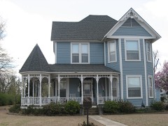 | Caldwell-Hopson House | building | 1993 | 93000150 |
Every wildfire the federal occurrence database records inside this county: 5 of them, burning about 27 acres. None started naturally and 1 was recorded as arson. Each settlement page carries the fires within five miles of it.
| Reported cause | Fires |
|---|---|
| Debris and open burning | 2 |
| Smoking | 1 |
| Arson/incendiarism | 1 |
| Fireworks | 1 |
The five largest, by the area the report gives. One of them was set deliberately.
| Date | Cause | Size | Reported by | Name on the report |
|---|---|---|---|---|
| 27 November 1998 | Smoking | 10 acres | Tennessee Division of Forestry | not named |
| 25 November 2012 | Debris and open burning | 7.0 acres | Tennessee Division of Forestry | REELFOOT DUCK |
| 5 July 2016 | Fireworks | 5.5 acres | Tennessee Division of Forestry | THE BIG BANG |
| 7 August 1999 | Arson/incendiarism | 3.8 acres | Tennessee Division of Forestry | not named |
| 22 March 1997 | Debris and open burning | under an acre | Lake Isom National Wildlife Refuge | ISOM HOUSE |
Every settlement page carries the fires within five miles of it - see the settlement index below.
The NOAA Storm Events Database holds 108 reports for this county, causing 3 deaths, 1 injury and about $7,805,701 in recorded property damage. Each settlement page carries the reports that name it.
| Kind of event | Reports |
|---|---|
| Thunderstorm Wind | 54 |
| Hail | 28 |
| Tornado | 10 |
| Flash Flood | 9 |
| Flood | 4 |
| Lightning | 3 |
The most serious of them, by death, then injury, then recorded damage. The accounts are quoted exactly as the forecast office filed them.
| When | Event | Place named | Harm | What the report says |
|---|---|---|---|---|
| December 2021 | Tornado (EF4) | Mooring | 3 killed, $4,500,000 | After traveling along the Mississippi River the tornado crossed into Lake County, Tennessee southwest of Wynnburg. The tornado significantly damaged trees with debarking southwest of Wynnburg. Homes and shop buildings suffered substantial damage north of Wynnburg. The tornado approached the Reelfoot Lake area and caused significant damage to a hotel, convenience store, restaurant, and camping facilities in the Cypress Point area. Three fatalities occurred in this area. On the southeast shore of Reelfoot Lake, the tornado damaged cabins and numerous recreational vehicles that were parked in a storage area. The tornado then crossed into Obion County, Tennessee. Peak winds in Lake County were estimated at 165-170 mph. |
| May 2020 | Thunderstorm Wind | Cottonwood | 1 hurt | A macroburst struck southern portions of Lake County causing widespread damage. Numerous trees and power lines were knocked down. A mobile home was destroyed in Ridgely. Many homes in the Cottonwood area suffered roof damaged. |
| May 2011 | Flood | Cottonwood | $750,000 | The Mississippi River rose to record levels in Tiptonville during the beginning to middle part of May. A few homes along the river were flooded and sustained damage while additional homes in Tiptonville were flooded and sustained minor damage. Campgrounds at Reelfoot Lake were flooded. Several thousand acres of agriculture fields were flooded. Several roads were flooded and/or damaged. Lake County Airport was closed due to the flooding. The river remained above flood stage through the end of the month. |
| April 2002 | Tornado (F1) | Tiptonville | $750,000 | The tornado touched down just west of Tiptonville and tracked northeast just north of Tiptonville. Eleven mobile homes were destroyed and another twelve were damaged. A shed was demolished. Five homes were also damaged. Numerous trees were blown down. |
| February 2019 | Flood | Tiptonville | $500,000 | Mutiple roads flooded and water rescue for vehicles and 8 people rescued in houses. |
| April 2000 | Hail | Tiptonville | $500,000 | Many leaves were taken off trees by the hail. Many cars and roofs were damaged by the hail as well. |
| May 2000 | Thunderstorm Wind | Tiptonville | $75,000 | A mobile home blew over on top of a truck. Several trees and power lines were knocked down. A few trees fell on houses. |
| May 2003 | Thunderstorm Wind | Madie | $70,000 | A church was destroyed. Five homes were damaged. Five utility poles were blown down. |
| May 1995 | Tornado (F2) | Obion Co | $70,000 | The tornado first tocuhed down about seven miles north of Tiptonville and continued to move northeast through the Reelfoot Lake area. The tornado then moved into Obion County near the town of Walnut Log and eventually moved into Fulton County, Kentucky. Two horses were killed when they were picked up by the tornado. One house had part of its roof torn off, lost part of his carport and had several windows broken. Another house lost part of its siding. Several boats and boat trailers were destroyed. A barn and six grain silos were destroyed. Some cotton trailers were blown over. Several trees and power lines were knocked down. Some crops were damaged as well. |
| May 2024 | Thunderstorm Wind | Tiptonville | $60,000 | At least 25 utility poles downed in Tiptonville and surrounding. Widespread tree damage and some structural damages including a metal building lost its roof. |
| April 2017 | Thunderstorm Wind | Tiptonville | $60,000 | Trees and power lines down. A few farm sheds and old buildings damaged. |
| June 2014 | Tornado (EF1) | New Markham | $50,000 | A tornado crossed over the Mississippi River from New Madrid County, Missouri and tracked through Lake County into Obion County. Damage across Lake County consisted of mainly tree damage with clear cutting and snapping of trees near the levee near the river towards Reelfoot Lake. |
| June 2004 | Thunderstorm Wind | Tiptonville | $30,000 | Several trees were blown down. One tree fell on a travel trailer destroying it. |
| April 2006 | Hail | Tiptonville | $25,000 | There were numerous reports of damage to vehicles and roofs caused by the tennis ball sized hail. |
| May 2004 | Thunderstorm Wind | Tiptonville | $25,000 | One house was damaged. Some trees were blown down. |
| September 2001 | Lightning | Tiptonville | $25,000 | The Lake County jail sustained electrical damage after the building took a lightning strike. |
| August 2001 | Lightning | Tiptonville | $25,000 | A lightning strike caused a 10" water main to be blown apart in two places. A pick-up truck, 2 televisions and 3 phones were also damaged by the lightning. |
| March 1978 | Tornado (F0) | not stated | $25,000 | no account filed |
| February 2021 | Flash Flood | Tiptonville | $15,000 | Flooding occurred across Tiptonville. Several inches of water flooded one structure. |
| May 2010 | Flash Flood | Proctor City | $15,000 | Heavy rain produced flash flooding near Tiptonville. Several roads were flooded. At least one home and one business sustained at least minor damage. A baseball field was flooded as well. |
| November 2005 | Thunderstorm Wind | Ridgely | $15,000 | One home was damaged. The roof was blown off of a shed. Several large trees were blown down. |
| July 2004 | Thunderstorm Wind | Tiptonville | $15,000 | A boat shed at the Blue Wing Hunting Lodge was damaged. Several trees were blown down. |
| October 2001 | Thunderstorm Wind | Tiptonville | $15,000 | A forty-foot cotton trailer was blown across two ditches and a road. Some cotton bales were blown apart. |
| July 2023 | Thunderstorm Wind | Tiptonville | $10,000 | A carport was lifted and tossed onto Highway 78 across from the Lake County Heath Department. |
| July 2005 | Tornado (F0) | Ridgely | $10,000 | The tornado briefly touched down in the community of Tank Two in southern Lake County. A shed large enough to hold a cotton picker was destroyed. A couple of trees were also knocked down. |
| August 2004 | Thunderstorm Wind | Tiptonville | $10,000 | A large tree fell onto a house. Some other homes were damaged. Several trees were blown down. |
| August 2004 | Thunderstorm Wind | Ridgely | $10,000 | Several trees and telephone poles were knocked down. |
| August 2004 | Flash Flood | Tiptonville | $10,000 | Several businesses were flooded, including the Tiptonville Dairy Queen. |
| May 2003 | Thunderstorm Wind | Wynnburg | $10,000 | A tree fell on a house in Wynnburg and shingles were stripped from a house in Owl City. |
| June 1999 | Lightning | Tiptonville | $10,000 | A building was damaged by a fire started by lightning. |
| June 1999 | Flood | Tiptonville | $10,000 | Several business were flooded after three inches of rain fell in one hour. |
| July 1998 | Thunderstorm Wind | Tiptonville | $10,000 | Several trees and power lines were blown down. |
| June 1997 | Thunderstorm Wind | Tiptonville | $10,000 | Several trees were knocked down. One fallen tree severely damaged the back of one home and knocked several holes in the roof. |
| April 2006 | Hail | Ridgely | $6,000 | no account filed |
| January 2020 | Thunderstorm Wind | Tiptonville | $5,000 | Straight-line winds snapped and uprooted trees in Tiptonville. |
| October 2007 | Thunderstorm Wind | Tiptonville | $5,000 | Several trees were blown down on Marcus Berry Lane in Tiptonville. |
| May 2003 | Thunderstorm Wind | Ridgely | $5,000 | One building was damaged. |
| May 2003 | Flash Flood | Ridgely | $5,000 | Many streets were flooded. |
| May 2002 | Thunderstorm Wind | Tiptonville | $5,000 | Several trees were knocked down. |
| February 2001 | Thunderstorm Wind | Ridgely | $5,000 | A couple of telephone poles were knocked down. |
| April 1999 | Thunderstorm Wind | Tiptonville | $5,000 | A few trees were blown down. One of the trees fell on a pickup truck. |
| June 1999 | Thunderstorm Wind | Tiptonville | $5,000 | Two utility poles were snapped in half. |
| April 1998 | Thunderstorm Wind | Wynnburg | $5,000 | A carport was torn from a house and blown onto a nearby highway. |
| June 1998 | Thunderstorm Wind | Ridgely | $5,000 | Several trees were knocked down. |
| July 1998 | Flash Flood | Ridgely | $5,000 | One road was flooded with water reaching up to the headlights. |
| April 1995 | Tornado (F0) | Ridgely | $5,000 | A tornado briefly touched in the northern part of the county. Several utility poles were snapped by the tornado. |
| April 1994 | Thunderstorm Wind | Madie | $5,000 | A mobile home was overturned and a storage shed was demolished. A swimming pool was blown into a fence. Several trees were knocked down as well. |
| April 2008 | Thunderstorm Wind | Tiptonville | $4,000 | Straight line winds blew trees down on Walnut Street in Tiptonville. |
| September 2006 | Thunderstorm Wind | Tiptonville | $4,000 | Straight line winds knocked down a few trees and a few signs near Tiptonville. |
| July 2006 | Thunderstorm Wind | Tiptonville | $2,000 | Several trees were downed along Highway 21 around Reelfoot Lake. |
| August 1995 | Thunderstorm Wind | Phillippi | $2,000 | A few trees were knocked down. |
| January 1996 | Thunderstorm Wind | Ridgely | $2,000 | no account filed |
| March 2006 | Thunderstorm Wind | Ridgely | $1,000 | Several large tree limbs were knocked down. |
| May 2002 | Flash Flood | Tiptonville | $1,000 | Several roads were flooded. |
| August 1998 | Flood | Tiptonville | $1,000 | Several roads were covered with water. |
| May 1998 | Hail | Tiptonville | $750 | no account filed |
| May 2019 | Thunderstorm Wind | Ridgely | $500 | Pole down on Highway 78. |
| April 1994 | Hail | Saulsbury | $500 | A mobile home was overturned and a storage shed was demolished. A swimming pool was blown into a fence. Several trees were knocked down as well. |
| May 1995 | Hail | Wynnburg | $500 | no account filed |
| February 2023 | Thunderstorm Wind | Tiptonville | $100 | Straight-line winds ripped a shutter off a home and knocked a few small limbs down. |
Named settlements recorded in the Geographic Names Information System, each with the topographic sheets covering it. Villages, hamlets and abandoned places alike. Each is shown with the nearest named watercourse or landform and the survey quadrangle it falls on.
District 3 · 38080 · Near Island Number Fifteen · Caruthersville quadrangle
13 sheets, 1939 to 1983