 Block
From the record
13 National Register listings published here.
Sources: the National Register database, National Park Service
68 topographic sheets cover 93 settlements here, and 13 properties are on the National Register of Historic Places.
13 National Register listings published here.
Sources: the National Register database, National Park Service
Every property in this county listed on the National Register of Historic Places, with the year it was listed and the federal nomination document.
| Photograph | Property | Type | Listed | Reference |
|---|---|---|---|---|
| Bank of Loretto | building | 2019 | 100004682 | |
 | Crockett Theater | building | 1997 | 97000804 |
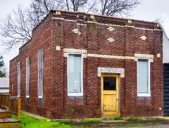 | Farmers and Merchants Bank | building | 2017 | 100001825 |
 | Garrett House | building | 2009 | 09000137 |
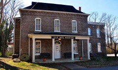 | Lawrence County Jail | building | 1976 | 76001784 |
| Lawrenceburg Commercial Historic District | district | 1992 | 92000346 | |
| Lawrenceburg No. 1 Hydroelectric Station | structure | 1990 | 90000308 | |
| Lawrenceburg No. 2 Hydroelectric Station | district | 1990 | 90001005 | |
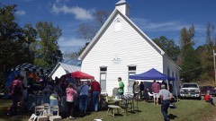 | Mount Zion Methodist Episcopal Church South | building | 1988 | 88000201 |
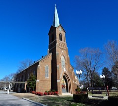 | Sacred Heart of Jesus Church | building | 1984 | 84000093 |
 | Sacred Heart of Jesus Church | building | 1984 | 84000094 |
| St. Joseph Church | building | 1984 | 84000113 | |
| St. Mary's Cemetery | site | 1984 | 84000095 |
Every wildfire the federal occurrence database records inside this county: 1,046 of them, burning about 5,058 acres. 9 started naturally and 263 were recorded as arson. Each settlement page carries the fires within five miles of it.
| Reported cause | Fires |
|---|---|
| Debris and open burning | 510 |
| Arson/incendiarism | 263 |
| Equipment and vehicle use | 92 |
| Missing data/not specified/undetermined | 75 |
| Smoking | 34 |
| Misuse of fire by a minor | 27 |
| Other causes | 11 |
| Recreation and ceremony | 11 |
| Natural | 9 |
| Fireworks | 9 |
| Power generation/transmission/distribution | 3 |
| Railroad operations and maintenance | 2 |
The five largest, by the area the report gives. Two of them were set deliberately.
| Date | Cause | Size | Reported by | Name on the report |
|---|---|---|---|---|
| 29 August 1999 | Arson/incendiarism | 235 acres | Tennessee Division of Forestry | not named |
| 22 August 1999 | Debris and open burning | 179 acres | Tennessee Division of Forestry | not named |
| 10 April 2014 | Debris and open burning | 108 acres | Tennessee Division of Forestry | LINDSLEY PLACE |
| 6 April 2002 | Arson/incendiarism | 108 acres | Tennessee Division of Forestry | not named |
| 8 April 2002 | Debris and open burning | 95 acres | Tennessee Division of Forestry | not named |
| 15 September 1999 | Smoking | 82 acres | Tennessee Division of Forestry | not named |
| 14 November 1999 | Debris and open burning | 75 acres | Tennessee Division of Forestry | not named |
| 7 February 2015 | Debris and open burning | 73 acres | Tennessee Division of Forestry | BRUSH CREEK RD |
Every settlement page carries the fires within five miles of it - see the settlement index below.
The NOAA Storm Events Database holds 733 reports for this county, causing 6 deaths, 153 injuries and about $33,067,450 in recorded property damage. Each settlement page carries the reports that name it.
| Kind of event | Reports |
|---|---|
| Thunderstorm Wind | 380 |
| Hail | 146 |
| Flash Flood | 118 |
| Tornado | 42 |
| Flood | 20 |
| Lightning | 15 |
| Funnel Cloud | 7 |
| Heavy Rain | 5 |
The most serious of them, by death, then injury, then recorded damage. The accounts are quoted exactly as the forecast office filed them.
| When | Event | Place named | Harm | What the report says |
|---|---|---|---|---|
| May 1995 | Tornado (F4) | Piney to | 3 killed, 32 hurt, $4,600,000 | The tornado touched down near the Lawrence/Wayne County line near Deerfield and lifted near Campbellsville in Giles County. Two people were killed while outside their trailer in the extreme western part of Lawrence County and a third person was killed while inside a house near Deerfield. Thirty-four houses, 16 mobile homes and one business were destroyed. Ninety-eight houses, three mobile homes and two other buildings were damaged. The tornado pulled corn stalks that were two feet tall out fo the ground and destroyed 6 TVA steel high-tension-wire towers. Three of these towers were never found. A cancelled check from Etheridge was found in Cannon County, some 90 miles away. Seventy-five to 100 people were evacuated in Ethridge because of downed power lines. (F48H,M65H,M67H) |
| July 1998 | Flash Flood | Lawrenceburg | 2 killed, 20 hurt, $4,000,000 | Synoptic conditions near the surface and aloft, set the stage for serious flooding problems in Lawrenceburg. A strong cut off low, located west of Lawrenceburg, caused a series of thunderstorms to train or move across Lawrence county. These thunderstorms contained very heavy rains. Precipitable water values were in excess of 2 inches that evening. There was a strong 850 mb moisture convergence field, along with 300 mb divergence, and also Lawrence county was in the right rear quadrant of the jet stream. Nashville Doppler Radar estimated about 8 inches of rain at Lawrenceburg Monday night and early Tuesday morning. 4 inches of rain fell in about an hour at one point Monday night. The Lawrenceburg Filtration Plant received 8.76 inches in a 24 hour period ending 7 AM CDT Tuesday, July 14. The Filtration Plant is a cooperative observer site for Lawrenceburg. Numerous roads were closed due to high water. There were 2 people killed and 20 injured. A 63 year old female was swept away in her car just east of David Crockett State Park on U.S. Highway 64 West bridge. The other fatality, a 74 year old male, was swept away in his car on U.S. Highway 43 bridge near the railroad trestle. The report of the fatalities was received at 1035 PM CDT from the emergency management office. 122 homes were damaged or destroyed, 13 mobile homes and several small bridges were swept away. 100 people had to be evacuated from their homes. 18 businesses sustained water damage. One home had 29 inches of water in it. The water and sewage plant was left inoperable, and residents had no water or bath facilities. Bottled water was distributed. Portable toilets were set up around town. Life was starting to return to normal on Saturday, July 18. |
| June 2014 | Flash Flood | New Haven | 1 killed, $500,000 | Major and widespread flash flooding occurred across northern Lawrence County, with several homes flooded and road closures due to roads being washed out in up to 20 different places. A 72 year old man drowned when his car was swept off the washed-out roadway at the intersection of Denson Road and Highway 240 in Summertown. Three people were rescued out of a flooded house at 35 Waterfork Road in Henryville. Buffalo Road at Highway 242 was down to one lane due to flooding. Highway 240 had 1 foot of water over the roadway. Branch Drive and Lance Drive in Lawrenceburg were also flooded. |
| April 1998 | Tornado (F5) | Deerfield | 21 hurt, $4,000,000 | Many fine homes, some even brick, were completely leveled. Trees were uprooted or blown down, power lines were down, 75 utility poles were blown down around the county. People who were at their homes went to the basement, or in a closet, or in a bathroom. The EMA report of a one ton Dodge flatbed truck, which weighs almost 5000 pounds, being hurled 20 miles, could not be confirmed. Therefore this account should be discounted. However, the EMA director verfied a sedan being carried 1/2 mile. A tree was debarked by the flying debris. A 200 yard wide path of pasture land had grass pulled out. Clumps of dirt was pulled up from the ground. Several livestock was killed. |
| June 1994 | Tornado (F3) | Wayne and | 19 hurt, $5,000,000 | The tornado first touched down near the town of Lutts in Wayne County and continued southeast into Lawrence. The tornado hit the towns of Iron City and St. Joseph before moving into Lauderdale County, Alabama. Several homes were damaged in Wayne County but the most significant damage occurred in Lawrence County. About 75% of the buildings in Iron City were damaged. Over 100 buildings were damaged in both St. Joseph and Iron City. Some cars were twisted and numerous trees were blown down. Nineteen persons were injured, most of them in Iron City. |
| July 2002 | Lightning | Lawrenceburg | 18 hurt | Lightning killed 9 cattle when they took shelter under a pecan tree. |
| April 1996 | Tornado (F2) | Barnesville | 12 hurt, $1,250,000 | no account filed |
| April 1972 | Tornado (F3) | not stated | 6 hurt, $250,000 | no account filed |
| December 2015 | Tornado (EF2) | New Haven | 3 hurt, $2,000,000 | This strong, long-track EF3 tornado touched down just east of the Hardin County/Wayne County line about 2.5 miles southwest of the town of Lutts. At touchdown, hundreds of trees were snapped and uprooted before the tornado reached its peak strength about one half mile west-southwest of Lutts along Lutts Road where the tornado reached a width of 800 yards and EF3 strength. A post office and church, both brick buildings, were destroyed along with multiple homes swept from their foundations. Four people were injured here in Lutts. As the tornado continued northeast, hundreds of trees were snapped and uprooted along its path to where a concentrated area of trees were destroyed about 5 miles north of Collinwood. The tornado continued snapping and uprooting trees until the Highway 64 and Natchez Trace Parkway intersection. At this location, an outbuilding was destroyed along with the roof of a mobile home. Further northeast into Lawrence County along Napier Road, a house was swept off its foundation where 3 people were injured. As the tornado traveled northeast, several homes with roofs completely removed or damaged heavily were found along Linville Road. The tornado weakened as it crossed Lewis County into Maury County where a barn was destroyed and many trees were snapped and uprooted along Joy Road, 2 miles southwest of Mount Pleasant. The total path length of the tornado across Wayne, Lawrence, Lewis and Maury Counties was 48.51 miles.||This is the first tornado on record to occur in Wayne County, Lewis County, and Maury County in the month of December. Lawrence County previously had one tornado in the month of December, which occurred on December 7, 1951. In addition, this was the strongest tornado to occur in the NWS Nashville county warning area since April 10, 2009. |
| March 1975 | Tornado (F1) | not stated | 3 hurt, $250,000 | no account filed |
| September 2024 | Thunderstorm Wind | Ethridge | 3 hurt, $25,000 | Severe thunderstorm winds downed powerlines and trees and blew roofs off of a few structures in Ethridge. A tent also collapsed due to the wind, leading to 3 injuries. Damages are a rough estimate. |
| March 1955 | Tornado (F1) | not stated | 2 hurt, $2,500 | no account filed |
| May 2001 | Thunderstorm Wind | Lawrenceburg | 2 hurt | Trees were down on U.S. Highway 64 and just east of the Natchez Trace Parkway in Lawrence county.A tree fell on the hood of a car, and threw 2 adults in the front seat into the windshield. The 2 were transported to a Lawrenceburg hospital. A child sitting in a child restraint device in the back seat was not injured. |
| April 2008 | Tornado (EF3) | Gaitherville | 1 hurt, $3,000,000 | Many homes had roof damage especially on Coffee McGee Rd. An outbuilding was damaged on Crawfish Rd. Trees and utility poles were down along U.S. Highway 64 or Waynesboro Highway. Trees were down in Mt. Ararat Cemetery. The worst damage was a downed TVA electrical transmission tower east of U.S. Highway 43 on Hagan Rd. Metal debris was flung up and got stuck about a hundred feet above the ground in an electrical transmission tower. Numerous trees were snapped and uprooted. ||Newspaper article stated 56 homes had damage, with 12 homes being complete losses, and there were mainly mobile homes having comp;lete;|||There was one minor injury. |
| April 2026 | Thunderstorm Wind | Barnesville | 1 hurt, $250,000 | A swath of damaging wind occurred across portions of northern Lawrence County in the early morning hours of April 28th. Damage was sporadic across the area consisting of snapped and uprooted trees and downed powerlines. There were a few trees that fell on either houses, farm outbuildings, or sheds. Additional damage included partial loss of roofing shingles on a house along the partial loss of metal roofing of a shop building. Winds were estimated to be between 60 to 70 mph for most areas though a few areas likely reached 80 to 90 mph. One injury occurred when a tree fell on an automobile. Damages are a rough estimate. |
| March 1963 | Tornado (F2) | not stated | 1 hurt, $250,000 | no account filed |
| February 2020 | Tornado (EF1) | Gaitherville | 1 hurt, $100,000 | This EF-1 tornado initially touched down along Glenn Springs Road downing several trees including a large tree falling on a house. The tornado then crossed Highway 64 continuing its destruction of mostly trees, power lines, and roofs as it moved through the city of Lawrenceburg. Several large trees were snapped or uprooted right in the heart of the city, especially around the public library where one tree fell onto the building and caused significant roof damage. The tornado then moved east-northeast into a more residential neighborhood where additional large trees were uprooted. The tornado weakened as it moved into rural eastern Lawrence County where mostly trees, outbuildings, and a barn were damaged. The tornado lifted just before reaching the Lawrence/Giles County line. |
| August 1998 | Flash Flood | Lawrenceburg | 1 hurt, $20,000 | Lawrence county 911 center reported several roads blocked off in Lawrenceburg and in the northern part of the county due to high water. There were 2 accidents on U.S. Highway 64 west of town that was attributed to the flash flooding. One accident did result in one injury. |
| April 2011 | Tornado (EF1) | Summertown | 1 hurt, $11,000 | The tornado first touched down near the intersection of Gresham and Moore Roads and lifted near the intersections of State Highways 240 and U.S. Highway 43. Hundreds of trees were snapped and several building suffered damage. A man suffered minor injuries when part of his home on Gresham Road collapsed. |
| May 1999 | Thunderstorm Wind | Lawrenceburg | 1 hurt, $10,000 | Vehicle blown off road in downtown Lawrenceburg. Driver had arm broken. |
| August 2025 | Lightning | Flatwoods | 1 hurt | A person was struck by lightning near Buffalo Road and Flatwoods Road near Ethridge. Fatalities were not reported, but extent of injuries was unknown. |
| May 2011 | Lightning | Lawrenceburg | 1 hurt | A county EMS employee was struck by lightning. Specific details concerning final condition of the employee who was struck, what type of injuries were received, and any associated medical cost were unknown. |
| May 2000 | Lightning | Lawrenceburg | 1 hurt | Lightning struck a person at a radio station. |
| May 1984 | Thunderstorm Wind | not stated | 1 hurt | no account filed |
| March 1963 | Tornado (F2) | not stated | 1 hurt | no account filed |
| May 2003 | Flash Flood | Countywide | $1,300,000 | Flooding was occurring countywide. Several people had to be evacuated. U.S. Highway 64 had to be closed due to high water near David Crockett State Park around 0844 AM CDT. 3 bridges have to be replaced (Waterloo Road, Shoally Branch Drive and Chief Creek Rd.) , 5 low water crossings will have to be reworked and miscellaneous metal culverts installed. Estimated cost of flood damage by EMA is $1.3 million. |
| March 2026 | Tornado (EF1) | Bonnertown | $750,000 | An EF-1 tornado began in Lauderdale County, Alabama and tracked into southern Middle TN. After the tornado crossed the Tennessee and Alabama state line, it traveled for ten more miles through Lawrence and Giles counties. In Bonnertown, many residences were impacted with several homes damaged. A few manufactured homes were moved off their piers, and a couple mobile homes were lofted or slid, but remained in tact. Other structural damage included missing awnings, removed shingles, carports thrown, and trees falling onto the structures. Several farm outbuildings were damaged. Numerous trees were snapped or uprooted. Beyond Bonnertown, the tornado continued east along Appleton Road, downing trees and destroying a chicken farm. The tornado then crossed into Giles County. Damages are a rough estimate. |
| May 2024 | Lightning | Lawrenceburg Arpt | $500,000 | A lightning strike was likely to blame for a house fire along Morgan Road in Lawrenceburg. Unfortunately, the house became engulfed in flames which led to the death of three individuals, including one pregnant woman. |
| August 2012 | Lightning | Lawrenceburg Arpt | $300,000 | Lightning struck a house at 58 Kelsey Drive in the New Prospect community east of Lawrenceburg. The resulting fire caused a total loss to the home. |
| May 2024 | Tornado (EF0) | Webber City | $250,000 | An EF-0 tornado touched down on Paige Road north of Ethridge and moved eastward along E Edan Rd and Marcella Falls Road before lifting near the Giles County line. Damage primarily consisted of numerous trees that were snapped, uprooted, or lost significant branches. A few farm outbuildings were destroyed, and a few houses had damage to the roof or flashing peeled off. Damages are a rough estimate. |
| March 1971 | Tornado (F1) | not stated | $250,000 | no account filed |
| March 1965 | Tornado (F2) | not stated | $250,000 | no account filed |
| May 2020 | Thunderstorm Wind | Lawrenceburg | $180,000 | Numerous trees and power lines were blown down across Lawrence County with several outbuildings and barns damaged. |
| August 2023 | Thunderstorm Wind | Lawrenceburg | $150,000 | A possible microburst caused damage in Lawrenceburg. The metal roofing of the Davy Crockett Motel along East Gaines Street was peeled back while multiple powerlines in the area where also downed. Numerous trees were also downed in Lawrenceburg, mostly north of the public square around Liberty Avenue. One of these trees fell onto a home. This damage resulted in 1,878 customers without power. No injuries reported. Damages are a rough estimate. |
| May 2010 | Flood | Flatwoods | $150,000 | Several streets were flooded in Lawrenceburg and the surrounding areas. Details concerning any flood damage amounts associated with this flooding were unknown.|Also, numerous homes, numerous businesses, numerous non comercial buildings, along with several county, state, and federal roads across the county received damage due to the flood. |
| May 2024 | Thunderstorm Wind | Lawrenceburg Arpt | $100,000 | Numerous trees and powerlines were reported down in Lawrence County, including Weakly Creek Road, Bonee Road near Gimlet Road, Martin Road, Crews Road, and in the Laurel Hill Wildlife Management Area. Damages are a rough estimate. |
| March 2023 | Thunderstorm Wind | Gum Spgs | $100,000 | Severe winds associated with a thunderstorm caused damage in the Lawrenceburg area. Along Quail Drive and along Old Florence Pulaski Road, several power poles were downed. This knocked out power to the northern half of the town. Damages are estimated. |
| June 2018 | Thunderstorm Wind | Springers Station | $100,000 | An NWS storm survey along with Lawrence County Emergency Management indicated a severe 4 mile long by 1/4 mile wide downburst struck the Leoma area. West of Leoma, 40 to 50 trees were blown down along Shoal Creek Road with 4 homes damaged from falling trees. Numerous more large trees and power lines were blown down in Leoma near the Leoma Baptist Church, with one tree falling onto and heavily damaging a house on Dunn Leoma Road. A billboard and outbuilding were also significantly damaged. Based on radar, damage also likely extended west and east of the path indicated here into inaccessible areas without roads. Winds were estimated up to 80 mph. |
| November 2018 | Tornado (EF1) | St Joseph | $100,000 | This EF-1 tornado touched down on Bluff Road causing minor roof damage to a home and breaking several large limbs outside the home. A nearby barn was heavily damaged. It traveled to the northeast where it encountered an oversized mobile home. Indications were that the strapping on the mobile home was rusty and not tied down well, allowing it to roll over. Winds here did seem strongest, however, topping out at 90 mph. The resident of the mobile home was able to escape to safety as he received the warning a couple minutes prior to the tornado striking his home. The tornado continued northeast and when it crossed South Ball Park Road, it demolished 2 hay barns and caused minor roof damage to 2 homes. As the tornado approached the city of Loretto, it caused extensive damage to the city's sports complex behind South Lawrence Elementary. Three cinder block dugouts were destroyed, two large sections of bleachers were tossed 25 to 30 yards and there was minor roof damage to the concession stand and an outbuilding where maintenance equipment was stored. Special thanks to the South Lawrence Elementary staff for provding video evidence of the tornado as it moved through the area. As the tornado approached Hwy 43, several homes were damaged by uprooted trees and there was some minor roof damage to a large outbuilding at a wood yard on 2nd Avenue. The tornado finished up by taking down power lines on the west side of Highway 43 near Vine Street and blowing down a few trees on the east side of Highway 43 before lifting. This tornado path was adjusted and extended slightly in May 2020 due to newly available Google Earth high resolution satellite imagery. |
| May 2010 | Thunderstorm Wind | St Joseph | $100,000 | Power polls and power lines downed around Loretto. Tree damage extending from St. Joseph to Leoma. Explanation of extent of tree damage was not given. |
| October 2004 | Flash Flood | Lawrenceburg | $100,000 | Urban street flooding was occurring. At 212 AM CST water was getting into homes in Lawrenceburg. A newspaper story said water rescues were made by the Swift Water Rescue Team, including one at Galbreath Subdivision, Jackson Street, Kathy Drive, Weakley Creek Road and Maple Avenue in Lawrenceburg. Other rescues were done on Prosser Road. 2 people were rescued at St. Joseph on U.S. Highway 64, as their car was swept 15 to 20 feet off the side of the roadway. As much as 5 inches of rain fell in 2 hours, and in some places 6 inches were reported. A water main bursted near Lawrenceburg, in the Stud Horse Canyon area just off Highway 64. The water main burst made matters worse. Water pressure became low to many businesses and residences. Schools were closed Tuesday and Wednesday, October 19th and 20th. Some roads in Lawrence County were completely washed out. |
| March 1997 | Tornado (F2) | New Haven | $100,000 | 2 houses were damaged and 1 trailer destroyed in Lawrence county. |
| September 1996 | Tornado (F1) | Leoma | $100,000 | no account filed |
| May 1999 | Thunderstorm Wind | Lawrenceburg | $97,000 | Spotter reported trees and power lines down 1 mile south of U.S. Highway 64 and S.R. 241. TEMA reported main expense was to restore utility service. |
| July 2025 | Flash Flood | Loretto | $50,000 | A slow-moving thunderstorm produced 4 to 6 inches of rain in southern Lawrence County, causing flash flooding in the Loretto, St. Joseph, and Iron City. Reports of flooding included across Fairview Road in Loretto, along South 2nd Avenue near South Lawrence Elementary School, along TN-277, and flooding inside the Iron City Fire Department. Damages are a rough estimate. |
| July 2012 | Thunderstorm Wind | Ethridge | $50,000 | Roof and ceiling of a house was blown off in Ethridge. |
| May 2010 | Flash Flood | Summertown | $50,000 | Total rainfall recorded at WLX Radio on North Locust Avenue in Lawrenceburg was 4.28 inches. This rainfall caused street flooding at various locations in Lawrenceburg as well as all over Lawrence County. Several swift water rescues were performed by Lawrence County Fire and Rescue. Lawrence County Highway Department workers were also out to blockade roads that were impassible due to the high water. Reports were received of water encroaching into a few structures, but no large scale flooding. |
| June 2009 | Thunderstorm Wind | Five Pts | $50,000 | Trees and power lines were down in southeast part of county. |
| July 2009 | Flash Flood | Chinubee | $50,000 | Campers were inundated by flood waters near the community of West Point in southern Lawrence County. Some vehicles were submerged in the flood waters. |
| September 2009 | Flood | Summertown | $50,000 | U.S. Highway 43, just north of Lawrenceburg, along with several other roads, especially across northwestern portions of the county, were flooded. Two school classrooms in Lawrence county were flooded. Name of school and location was unknown. |
| May 2008 | Tornado (EF1) | St Joseph | $50,000 | A large tree fell on a house at 834 Clax Branch Rd. A number of trees were snapped and uprooted. A barn on Clax Branch Road was destroyed. |
| April 2011 | Thunderstorm Wind | Center Pt | $40,000 | Multiple structures were damaged and numerous trees were blown down along State Highway 98 south of Lawrenceburg. Specific details on type of damage to structures and associated cost were unknown. |
| February 2009 | Thunderstorm Wind | Lawrenceburg | $40,000 | A roof was blown of a home with numerous trees down in the vicinity. |
| May 2011 | Thunderstorm Wind | Long Branch | $35,000 | A mobile home was turned over and a person was trapped inside. Specific details concerning if the mobile home received any damage and if the person inside received any injuries were unknown. |
| May 2006 | Thunderstorm Wind | Lawrenceburg | $35,000 | Tree was blown down on a mobil home. Newspaper story estimated damage to be around $35,000. |
| April 2011 | Thunderstorm Wind | Loretto | $30,000 | Several buildings sustained roof damage in Loretto and the surrounding areas. Specific types of buildings damaged and associated cost were unknown. |
| February 2025 | Thunderstorm Wind | Bonnertown | $25,000 | Strong thunderstorm winds in southern Lawrence County destroyed a barn that was under construction. Damage to tree branches was also reported. Damages are a rough estimate. |
| May 2025 | Thunderstorm Wind | Lawrenceburg | $25,000 | Severe thunderstorm winds downed a tree onto a home on Lawrence Street in Lawrenceburg. Damages are a rough estimate. |
| April 2025 | Thunderstorm Wind | Lawrenceburg | $25,000 | Severe thunderstorm winds downed trees and powerlines in Lawrenceburg. One of these trees reportedly fell on a home. Damages are a rough estimate. |
| April 2025 | Thunderstorm Wind | Webber City | $25,000 | Severe thunderstorm winds caused minor roof damage to Thousand Hills Cowboy Church in Ethridge. Damages are a rough estimate. |
The Survey's mineral resources record lists 31 workings inside this county. 2 still produce and 29 are closed or unrecorded. Each settlement page carries the workings within five miles of it.
| Commodity | Workings |
|---|---|
| Iron | 21 |
| Stone, Crushed/Broken | 4 |
| Limestone, Dimension | 2 |
| Stone, Crushed/Broken, Limestone, General | 1 |
| Limestone, General | 1 |
| Stone, Dimension | 1 |
| Silica | 1 |
The least common of them first, because a county's hundredth gravel pit says nothing its first ten did not.
| Where | Site | Commodity | Status | Recorded |
|---|---|---|---|---|
| Chert Mine | Silica | Past Producer | ||
| Lawrence Co. Limestone Co. Quarry | Limestone, General | Past Producer | Sedimentary | |
| Lawrenceburg Materials | Stone, Crushed/Broken, Limestone, General | Producer | Limestone | |
| McKinney Mine | Stone, Dimension | Past Producer | ||
| Quarry | Limestone, Dimension | Past Producer | ||
| Quarry | Limestone, Dimension | Past Producer | ||
| Lawrence Co. Limestone Co. Quarry | Stone, Crushed/Broken | Past Producer | ||
| Lawrence County Quarry and Mill | Stone, Crushed/Broken | Producer | ||
| Lime Quarry | Stone, Crushed/Broken | Past Producer | ||
| Quarry | Stone, Crushed/Broken | Past Producer | ||
| Allen Prospect | Iron | Prospect | ||
| Brush Creek Prospect No. 1 | Iron | Prospect | ||
| Brush Creek Prospect No. 2 | Iron | Prospect | ||
| Brush Creek Prospect No. 3 | Iron | Prospect | ||
| Burkett Mine | Iron | Past Producer | ||
| Cedar Point Mine | Iron | Past Producer | ||
| Couch Mine | Iron | Past Producer | ||
| Dodd Mine | Iron | Past Producer | ||
| Drake Mine | Iron | Past Producer | ||
| Hessemer No. 1 Mine | Iron | Past Producer | ||
| Hessemer No. 2 Mine | Iron | Past Producer | ||
| Hopkins Prospect | Iron | Prospect | ||
| Ironsides Mine | Iron | Past Producer | ||
| Little Hill Mine | Iron | Past Producer | ||
| Neal Property | Iron | Occurrence | ||
| Pinkney Mine | Iron | Past Producer | ||
| Powell Mine | Iron | Past Producer | ||
| Seavy-Lull Mine | Iron | Past Producer | ||
| Sharp Mine | Iron | Past Producer | ||
| Wisdom Mine | Iron | Past Producer | ||
| Wright Mine | Iron | Past Producer |
Named settlements recorded in the Geographic Names Information System, each with the topographic sheets covering it. Villages, hamlets and abandoned places alike. Each is shown with the nearest named watercourse or landform and the survey quadrangle it falls on.
District 10 · 38456 · On Brewer Branch · Summertown quadrangle
12 sheets, 1936 to 1985
District 2 · 38469 · On Licklog Branch · Loretto quadrangle
12 sheets, 1936 to 1985
District 16 · 38464 · On Little Shoal Creek · Ethridge quadrangle
12 sheets, 1936 to 1985
District 11 · 38483 · On Gum Springs Branch · Summertown quadrangle
12 sheets, 1936 to 1985
District 6 · 38464 · On Greenbrier Branch · Long Branch quadrangle
11 sheets, 1936 to 1985
District 3 · 38468 · On Idaho Branch · Bonnertown quadrangle
12 sheets, 1936 to 1985
No longer a settlement
District 15 · 38464 · On Crowson Creek · Lawrenceburg quadrangle
12 sheets, 1936 to 1985
District 6 · 38469 · Near Fisher Hollow · Loretto quadrangle
12 sheets, 1936 to 1985
No longer a settlement
District 7 · 38464 · On Beeler Fork · Lawrenceburg quadrangle
12 sheets, 1936 to 1985
District 6 · 38486 · Near Limekiln Hollow · Long Branch quadrangle
11 sheets, 1936 to 1985
District 16 · 38464 · On Little Shoal Creek · Lawrenceburg quadrangle
12 sheets, 1936 to 1985
District 12 · 38464 · On Nomeet Branch · Henryville quadrangle
12 sheets, 1936 to 1985
No longer a settlement
District 3 · 38457 · On Mockeson Branch · Bonnertown quadrangle
12 sheets, 1936 to 1985
District 10 · 38456 · Campbellsville quadrangle
13 sheets, 1936 to 1985
No longer a settlement
District 16 · 38464 · On Little Shoal Creek · Ethridge quadrangle
12 sheets, 1936 to 1985
District 13 · 38464 · On Dryden Branch · Long Branch quadrangle
11 sheets, 1936 to 1985
District 9 · 38456 · Near Beckham Hollow · Campbellsville quadrangle
13 sheets, 1936 to 1985
District 6 · 38486 · On Factory Creek · Saint Joseph quadrangle
13 sheets, 1905 to 1985
No longer a settlement
District 3 · 38468 · On Turkey Creek · Lawrenceburg quadrangle
12 sheets, 1936 to 1985
No longer a settlement
District 11 · 38483 · On Camp Branch · Summertown quadrangle
12 sheets, 1936 to 1985
No longer a settlement
District 1 · 38481 · On Carter Branch · Saint Joseph quadrangle
13 sheets, 1905 to 1985
District 8 · 38464 · Near Oak Hill · Campbellsville quadrangle
13 sheets, 1936 to 1985
No longer a settlement
District 4 · 38468 · On Butler Branch · Lawrenceburg quadrangle
12 sheets, 1936 to 1985
No longer a settlement
District 6 · 38469 · Near Coplin Hollow · Long Branch quadrangle
11 sheets, 1936 to 1985
District 12 · 38464 · On Simmons Gin Branch · Riverside quadrangle
14 sheets, 1905 to 1985
No longer a settlement
District 11 · 38483 · On North Fork Saw Creek · Summertown quadrangle
12 sheets, 1936 to 1985
District 13 · 38464 · Near Staggs Hollow · Riverside quadrangle
14 sheets, 1905 to 1985
District 3 · 38468 · On Flatrock Branch · Bonnertown quadrangle
12 sheets, 1936 to 1985
District 10 · 38456 · Near O'Rear Hollow · Campbellsville quadrangle
13 sheets, 1936 to 1985
No longer a settlement
District 6 · 38463 · On Brewer Branch · Saint Joseph quadrangle
13 sheets, 1905 to 1985
District 3 · 38468 · On Swinney Branch · Bonnertown quadrangle
12 sheets, 1936 to 1985
No longer a settlement
District 6 · 38463 · On Little Wolf Creek · Saint Joseph quadrangle
13 sheets, 1905 to 1985
The vanished settlements of Lawrence County: the places named above that are no longer on the map.