 Block
From the record
4 National Register listings published here.
Sources: the National Register database, National Park Service
37 topographic sheets cover 29 settlements here, and 4 properties are on the National Register of Historic Places.
4 National Register listings published here.
Sources: the National Register database, National Park Service
Every property in this county listed on the National Register of Historic Places, with the year it was listed and the federal nomination document.
| Photograph | Property | Type | Listed | Reference |
|---|---|---|---|---|
| Ambrose Blackburn Farmstead | building | 1985 | 85000670 | |
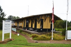 | Hohenwald Railroad Depot | building | 1987 | 87000730 |
 | Lewis County Courthouse | building | 2006 | 06000203 |
| Netherland Tait House | building | 1984 | 84003577 |
Every wildfire the federal occurrence database records inside this county: 489 of them, burning about 3,190 acres. 4 started naturally and 141 were recorded as arson. Each settlement page carries the fires within five miles of it.
| Reported cause | Fires |
|---|---|
| Debris and open burning | 179 |
| Arson/incendiarism | 141 |
| Missing data/not specified/undetermined | 63 |
| Equipment and vehicle use | 36 |
| Recreation and ceremony | 33 |
| Smoking | 12 |
| Other causes | 9 |
| Power generation/transmission/distribution | 5 |
| Misuse of fire by a minor | 5 |
| Natural | 4 |
| Railroad operations and maintenance | 1 |
| Fireworks | 1 |
The five largest, by the area the report gives. Five of them were set deliberately.
| Date | Cause | Size | Reported by | Name on the report |
|---|---|---|---|---|
| 7 February 2015 | Arson/incendiarism | 235 acres | Tennessee Division of Forestry | TIGER FIRE |
| 17 March 2011 | Missing data/not specified/undetermined | 218 acres | Natchez Trace Parkway | REED ROAD |
| 22 February 2007 | Debris and open burning | 174 acres | Tennessee Division of Forestry | SLAUGHTER PEN HOLLOW |
| 3 March 2011 | Arson/incendiarism | 118 acres | Tennessee Division of Forestry | ROCKDALE TRACE FIRE |
| 17 November 2001 | Arson/incendiarism | 75 acres | Tennessee Division of Forestry | not named |
| 17 August 2000 | Arson/incendiarism | 70 acres | Tennessee Division of Forestry | not named |
| 21 March 2009 | Debris and open burning | 58 acres | Tennessee Division of Forestry | HONEYSUCKIE FIRE |
| 21 April 2007 | Arson/incendiarism | 50 acres | Tennessee Division of Forestry | THREE DAY FIRE |
Every settlement page carries the fires within five miles of it - see the settlement index below.
The NOAA Storm Events Database holds 193 reports for this county, causing 1 death, 18 injuries and about $29,035,768 in recorded property damage. Each settlement page carries the reports that name it.
| Kind of event | Reports |
|---|---|
| Thunderstorm Wind | 95 |
| Hail | 49 |
| Flash Flood | 21 |
| Tornado | 17 |
| Heavy Rain | 6 |
| Flood | 2 |
| Funnel Cloud | 2 |
| Lightning | 1 |
The most serious of them, by death, then injury, then recorded damage. The accounts are quoted exactly as the forecast office filed them.
| When | Event | Place named | Harm | What the report says |
|---|---|---|---|---|
| March 1991 | Tornado (F2) | not stated | 1 killed, 14 hurt, $25,000,000 | no account filed |
| May 2009 | Tornado (EF1) | Hohenwald | 2 hurt, $200,000 | This EF1 Tornado, with maximum estimated wind speed at 100 mph, started 8 miles south-southeast of Hohenwald in Lewis County, or just west of Napier, and moved east into far northwest Lawrence County. It snapped or uprooted many hundreds of large hardwood trees. It also flipped a tractor trailer. The hardest hit area was a large campground in Napier. In addition to the trees, several large camper trailers were damaged or flipped by the tornado. Two people sustained minor injuries and had to be rescued from inside the camper.||Newspaper also reported that three homes received damage but details of damage not given. |
| September 2025 | Thunderstorm Wind | Napier | 1 hurt, $5,000 | A tree fell onto a car along Natchez Trace Parkway southeast of Hohenwald. There was one injury from the occupant of the car. Damages are a rough estimate. |
| May 2010 | Lightning | Hohenwald | 1 hurt | Lewis County 911 Center reported one person was struck by lightning in Holenwald. No additional details were provided on injuries this person sustained due to this lightning strike. |
| March 2023 | Tornado (EF1) | Riverside | $900,000 | This narrative continues and concludes a long track tornado that began in NWS Memphis's area before entering Wayne County in NWS Nashville's area. After leaving Wayne County, the tornado continued into Lewis County along Cothran Road and continued northeast across Seiber Ridge Road, Rockhouse Road, Howard Switch Road, Buffalo Road, and the Natchez Trace Parkway at Summertown Highway, blowing down hundreds of more trees and damaging several homes and outbuildings. The last damage was noted on Tiger Bennett Road before the tornado lifted west of Big Swan Road. Damages are estimated for Lewis County. |
| February 2008 | Tornado (EF0) | Hohenwald Baker Arpt | $500,000 | Across extreme northwest Lewis County, trailers were destroyed. Roofs were damaged. Barns and outbuildings were flattened along McCord Hollow Road and Cane Creek Rd.||TEMA reported 6 homes had major damage, one mobile home was destroyed in Lewis County. |
| May 2010 | Flood | Kimmins | $430,000 | State Highway 20, from Hohenwald down to the Lawrence County Border, had water across the road in numerous locations, making the road impassible. Also, county's swift water rescue team reported that State Highway 20 was flooded at multiple locations between the Natchez Trace Parkway and Hohenwald. Numerous homes and businesses|across the county also received flood damage. Also, additonal roads across the county|were impassible. |
| January 2013 | Tornado (EF1) | Shubert | $250,000 | An EF1 tornado touched down south of Hohenwald along Wildwood Road and moved eastward through rural forested areas before lifting east of Highway 20 to the south of Springer Church House Road. A mobile home had minor roof damage on Swiss Colony Road. 1 mobile home was completely destroyed, 5 mobile homes were damaged, and an outbuilding was destroyed on the south end of Kayla Lane. Another mobile home lost its roof on the east end of Colonial Road and 2 others were damaged. A house on Highway 20 just south of Grinder Creek Road suffered minor roof damage. Hundreds of trees were snapped and uprooted all along the path. Aerial and street view imagery from Google Earth greatly assisted with this storm survey. |
| May 2009 | Flash Flood | Kimmins | $250,000 | Roads in the Cane Creek and McCord Hollow area were all but destroyed as flood waters lifted the asphalt from the roadways and piled it up where ever the water receded. Highway Commissioner Ronnie Darnell said the damage, which was widespread across Lewis County, was the worst he had seen since he took office in 1977. Bridges across the county also suffered damage as asphalt and dirt around the bridges was washed away. A outbuilding at a sawmill on Slippery Creek Road left its foundation when the flood waters rose, along with other damage at the sawmill directly attributed to flash flooding. |
| May 2003 | Flash Flood | Countywide | $250,000 | TEMA and FEMA estimated flood damage to be at $250K for numerous roads and bridges across Lewis county. |
| January 2002 | Flash Flood | Countywide | $225,000 | Highway department reported some roads closed due to stream overflow. Damage to roads and bridges estimated at $225,000. |
| May 2020 | Thunderstorm Wind | Hohenwald | $145,000 | Roofs were blown off several buildings and numerous trees were blown down in Hohenwald. |
| March 2017 | Tornado (EF1) | Hohenwald Baker Arpt | $100,000 | This EF-1 tornado touched down in a forested area in extreme eastern Perry County north of Stanley Hinson Road then moved northeast, blowing down numerous trees before crossing Highway 412 into Lewis County. The tornado strengthened as it continued northeast, snapping and uprooting hundreds of hardwood and softwood trees and causing some minor roof and outbuilding damage on McCord Hollow Road. Continuing northeast across Goodman Branch Road, the tornado blew down more trees and passed within a mile of the tornado that occurred almost exactly one year prior on March 31, 2016. The tornado weakened as it turned more eastward, but continued to blow down dozens of trees as it crossed Darbytown Road and Coble Road. A barn was damaged on Keeton Drive and many more trees were blown down on both sides of Highway 48. Scattered trees continued to be blown down further to the east across rural forested areas before the tornado finally lifted just west of Indian Creek Road. The total path length across Perry and Lewis Counties was 9.75 miles. The damage summary, beginning and ending times, path length, and path width of this tornado were updated in July 2019 based on newly available high resolution satellite imagery in Google Earth. |
| May 2009 | Flash Flood | Gordonsburg | $100,000 | Homes were flooded on Mt Joy Road. |
| March 1997 | Tornado (F2) | Napier | $100,000 | 5 homes were damaged and a barn was destroyed. Path length and width of tornado are approximations. |
| April 2026 | Thunderstorm Wind | Hohenwald | $50,000 | Severe thunderstorm winds caused damage to powerlines in the Hohenwald area, resulting in numerous power outages. Damages are a rough estimate. |
| June 2014 | Flash Flood | Riverside | $50,000 | Major flash flooding affected much of Lewis County throughout the day on June 5 with numerous road closures, including Highway 412 in Hohenwald which was under water. The worst flooding was in the Buffalo River area of southern Lewis County, where several bridges were washed out. |
| July 1995 | Thunderstorm Wind | Hohenwald | $50,000 | A roof was blown off of a house. Overall, six barns and 67 homes were damaged. Numerous trees and power lines were blown down. |
| April 2025 | Thunderstorm Wind | Hohenwald | $30,000 | Severe thunderstorm winds downed trees and powerlines as well as destroyed an outbuilding in Hohenwald. Damages are a rough estimate. |
| May 2011 | Thunderstorm Wind | Blondy | $25,000 | Trees were downed on cars and resulted in power outages on Howard Switch Road. Specific details concerning any damage to the cars were unknown. |
| May 2010 | Thunderstorm Wind | Blondy | $25,000 | Lewis County 911 Center reported trees were downed in the Swan Avenue section of Hohenwald. |
| May 2009 | Flash Flood | Kimmins | $25,000 | Home was flooded on Cane Creek Road. |
| August 2023 | Thunderstorm Wind | Hohenwald | $20,000 | Severe thunderstorm winds downed a large oak tree onto a home in Hohenwald. Damages are a rough estimate. |
| March 2021 | Tornado (EF0) | Voorhies | $20,000 | A strong EF-2 tornado touched down just northeast of the city of Waynesboro between Highway 64 and Highway 99. The tornado increased in intensity rapidly as it tracked through neighborhoods along Highway 99. A few trees and outbuildings were blown down and destroyed at the beginning of the track before the tornado moved across Steele Street, Hassell Drive, High Street, and Natural Bridge Road, taking the roofs off several homes and causing one minor injury. Five high power TVA electrical steel poles were bent to the ground in this area, knocking out power to all of Wayne County. Continuing northeastward, the tornado destroyed a barn on York Road and damaged several homes on Fortyeight Creek Road. The tornado then moved through rural, forested and hilly terrain with few roads for a total of 22.2 miles across northeast Wayne, extreme southern Lewis, and extreme northwestern Lawrence Counties, blowing down hundreds of trees before finally lifting around 4 miles northwest of Summertown. |
| March 2021 | Tornado (EF0) | Napier | $20,000 | A strong EF-2 tornado touched down just northeast of the city of Waynesboro between Highway 64 and Highway 99. The tornado increased in intensity rapidly as it tracked through neighborhoods along Highway 99. A few trees and outbuildings were blown down and destroyed at the beginning of the track before the tornado moved across Steele Street, Hassell Drive, High Street, and Natural Bridge Road, taking the roofs off several homes and causing one minor injury. Five high power TVA electrical steel poles were bent to the ground in this area, knocking out power to all of Wayne County. Continuing northeastward, the tornado destroyed a barn on York Road and damaged several homes on Fortyeight Creek Road. The tornado then moved through rural, forested and hilly terrain with few roads for a total of 22.2 miles across northeast Wayne, extreme southern Lewis, and extreme northwestern Lawrence Counties, blowing down hundreds of trees before finally lifting around 4 miles northwest of Summertown. |
| July 2023 | Thunderstorm Wind | Hohenwald | $10,000 | A Facebook user reported several trees were downed across Lewis County due to severe thunderstorm winds. Damages are a rough estimate. |
| February 2014 | Thunderstorm Wind | Hohenwald | $10,000 | The front brick wall of the Lewis County Herald newspaper building collapsed due to high thunderstorm winds. |
| January 2013 | Thunderstorm Wind | Hohenwald | $10,000 | A tree fell on mobile home and knocked it off its foundation in Hohenwald. |
| January 2013 | Tornado (EF1) | Riverside | $10,000 | An EF1 tornado moved out of Wayne County into Lewis County where 5 power poles were snapped along Seiber Ridge Road and numerous more trees were uprooted. Aerial imagery from Google Earth greatly assisted with this storm survey. |
| August 2011 | Thunderstorm Wind | Hohenwald | $10,000 | Emergency Manager reported numerous trees and power lines blown down and roof damage to buildings along Swan Avenue near Park Street in Hohenwald. |
| April 2011 | Thunderstorm Wind | Napier | $10,000 | Trees were downed on State Highway 241 near the Lawrence County line. |
| August 2010 | Flash Flood | Blondy | $10,000 | Car was stuck on Grinders Creek Road near State Highway 20 as flood waters came over the road. |
| October 2010 | Thunderstorm Wind | Hohenwald | $10,000 | A few trees were downed in Hohenwald. |
| October 2010 | Thunderstorm Wind | Gordonsburg | $10,000 | Trees were downed on State Highway 20 in the southeastern part of the county. |
| October 2010 | Thunderstorm Wind | Hohenwald | $10,000 | Trees were blown down on Highway 99. |
| May 2010 | Thunderstorm Wind | Hohenwald Baker Arpt | $10,000 | Trees were downed on U.S. Highway 412 just west of Linden. |
| May 2009 | Flash Flood | Kimmins | $10,000 | Five and seventy three one hundreths inches of rain had fallen during the past 24 hours. Observer notes that this is the highest water level he had seen on Upper Cane Creek in 7 years by a couple of feet. Many county roads were also flooded. |
| May 2010 | Thunderstorm Wind | Hohenwald | $9,000 | Trees and lines were blown down on Centerville Highway. |
| January 2020 | Thunderstorm Wind | Hohenwald | $5,000 | Trees were blown down across Lewis County. |
| July 2020 | Thunderstorm Wind | Gordonsburg | $5,000 | Several trees and power lines were blown down along Highway 412 from Little Swan Creek Road eastward to the Maury County line. |
| June 2019 | Thunderstorm Wind | Hohenwald | $5,000 | Trees and power lines were blown down across Lewis County with power outages, especially on Highway 20. |
| May 2018 | Thunderstorm Wind | Napier | $5,000 | Several trees were blown down with minor exterior damage to homes in the 600 block of Metal Ford Road. Although no storm survey was conducted for this damage, radar data indicates this may have been a brief EF0 tornado. |
| March 2016 | Tornado (EF0) | Hohenwald Baker Arpt | $5,000 | An EF0 tornado touched down about 4 miles northwest of Hohenwald in northwestern Lewis County. It was a rare, anticyclonic tornado (rotating clockwise). A few trees were uprooted and snapped along Darbytown Road with several large branches downed as well. Minor roof damage occurred to a barn and house along its 1 mile path. At its peak, winds were estimated at 80 mph and the path width was approximately 50 yards. |
| March 2016 | Tornado (EF0) | Hohenwald Baker Arpt | $5,000 | An EF1 tornado touched down about 7 miles southeast of Linden in eastern Perry County. It weakened to an EF0 in far western Lewis County before lifting. The tornado touched down in Boneyard Hollow where several hundred trees were uprooted, snapped, or downed along its path before entering Lewis County. The tornado weakened to an EF0 there and damaged an outbuilding before lifting 7 miles west of Hohenwald. At its peak, the tornado path width was 350 yards and winds were estimated at 90 mph. The tornado path length was approximately 4 miles. |
| February 2014 | Thunderstorm Wind | Hohenwald Baker Arpt | $5,000 | Several trees were blown down in northwestern Lewis County. |
| December 2013 | Thunderstorm Wind | Hohenwald | $5,000 | Numerous trees were blown down across Lewis County. |
| January 2013 | Thunderstorm Wind | Voorhies | $5,000 | A couple of trees were downed with power outages on Morris Road and Long Branch Road. |
| June 2012 | Thunderstorm Wind | Blondy | $5,000 | A few trees were blown down on Centerville Highway. |
| October 2012 | Thunderstorm Wind | Hohenwald Baker Arpt | $5,000 | Roof shingles were reportedly blown off a home on Garrison Road near Hohenwald where a wind gust of 48 mph was measured. |
| September 2012 | Thunderstorm Wind | Oak Grove | $5,000 | A tree was downed on Buffalo Road and also on Howard Switch Road. |
| June 2011 | Thunderstorm Wind | Hohenwald | $5,000 | Trees were blown down across the southern portion of Lewis County. |
| August 2005 | Thunderstorm Wind | Hohenwald | $5,000 | Newspaper story about 2 trees that was blown down and fell on the General Assembly Academy. One tree fell on another tree, which caused both trees to clip the corner of a roof, and took the front porch covering and some siding on the building. |
| June 1998 | Thunderstorm Wind | Hohenwald | $5,000 | Trees were blown down and a trailer was tipped over from strong thunderstorm winds. |
| June 1997 | Thunderstorm Wind | Gordonsburg | $5,000 | A few trees and power lines were down. |
| May 1995 | Thunderstorm Wind | Hohenwald | $5,000 | Some trees were blown down. |
| November 1994 | Thunderstorm Wind | Gordonsburg | $5,000 | A few trees were knocked down. |
| May 2021 | Thunderstorm Wind | Blondy | $3,000 | Trees were blown down on Woodmere drive and there were multiple reports of strong winds across the area. |
| June 2020 | Thunderstorm Wind | Gordonsburg | $3,000 | Multiple trees were blown down across eastern Lewis County. |
| June 2018 | Thunderstorm Wind | Mt Joy | $3,000 | Tress were blown down on south West Fork Road. |
| March 2017 | Thunderstorm Wind | Gordonsburg | $3,000 | A few trees were blown down on Highway 20 east of Hohenwald. |
The Survey's mineral resources record lists 74 workings inside this county. None of them still produces: all are closed or unrecorded. Each settlement page carries the workings within five miles of it.
| Commodity | Workings |
|---|---|
| Iron | 68 |
| Stone, Crushed/Broken | 5 |
| Sulfur | 1 |
The least common of them first, because a county's hundredth gravel pit says nothing its first ten did not.
Named settlements recorded in the Geographic Names Information System, each with the topographic sheets covering it. Villages, hamlets and abandoned places alike. Each is shown with the nearest named watercourse or landform and the survey quadrangle it falls on.
District 4 · Near Washer Hollow · Riverside quadrangle
14 sheets, 1905 to 1985
No longer a settlement
District 4 · 38462 · Near Rockhouse Creek Valley · Riverside quadrangle
14 sheets, 1905 to 1985
District 6 · 38462 · Near Ammons Hollow · Hohenwald quadrangle
13 sheets, 1936 to 1986
No longer a settlement
District 4 · 38462 · Near Staggs Hollow · Riverside quadrangle
14 sheets, 1905 to 1985
No longer a settlement
District 3 · 38462 · Near Booker Hollow · Hohenwald quadrangle
13 sheets, 1936 to 1986
District 1 · 38461 · On Trotters Branch · Mount Joy quadrangle
15 sheets, 1901 to 1986
No longer a settlement
District 4 · 38462 · Near Pope Hollow · Riverside quadrangle
14 sheets, 1905 to 1985
No longer a settlement
District 4 · 38462 · Near Falls Hollow · Riverside quadrangle
14 sheets, 1905 to 1985
No longer a settlement
District 2 · 38483 · Near Dark Hollow · Gordonsburg quadrangle
15 sheets, 1901 to 1986
No longer a settlement
District 2 · 38462 · Near Jones Hollow · Gordonsburg quadrangle
15 sheets, 1901 to 1986
No longer a settlement
District 7 · 38462 · Near Panther Hollow · Gordonsburg quadrangle
15 sheets, 1901 to 1986
No longer a settlement
The vanished settlements of Lewis County: the places named above that are no longer on the map.