 Block
From the record
One of 204 National Register listings published here for Davidson County · listed in 2006 · category: Building.
Sources: the National Register database, National Park Service · the Wikipedia article
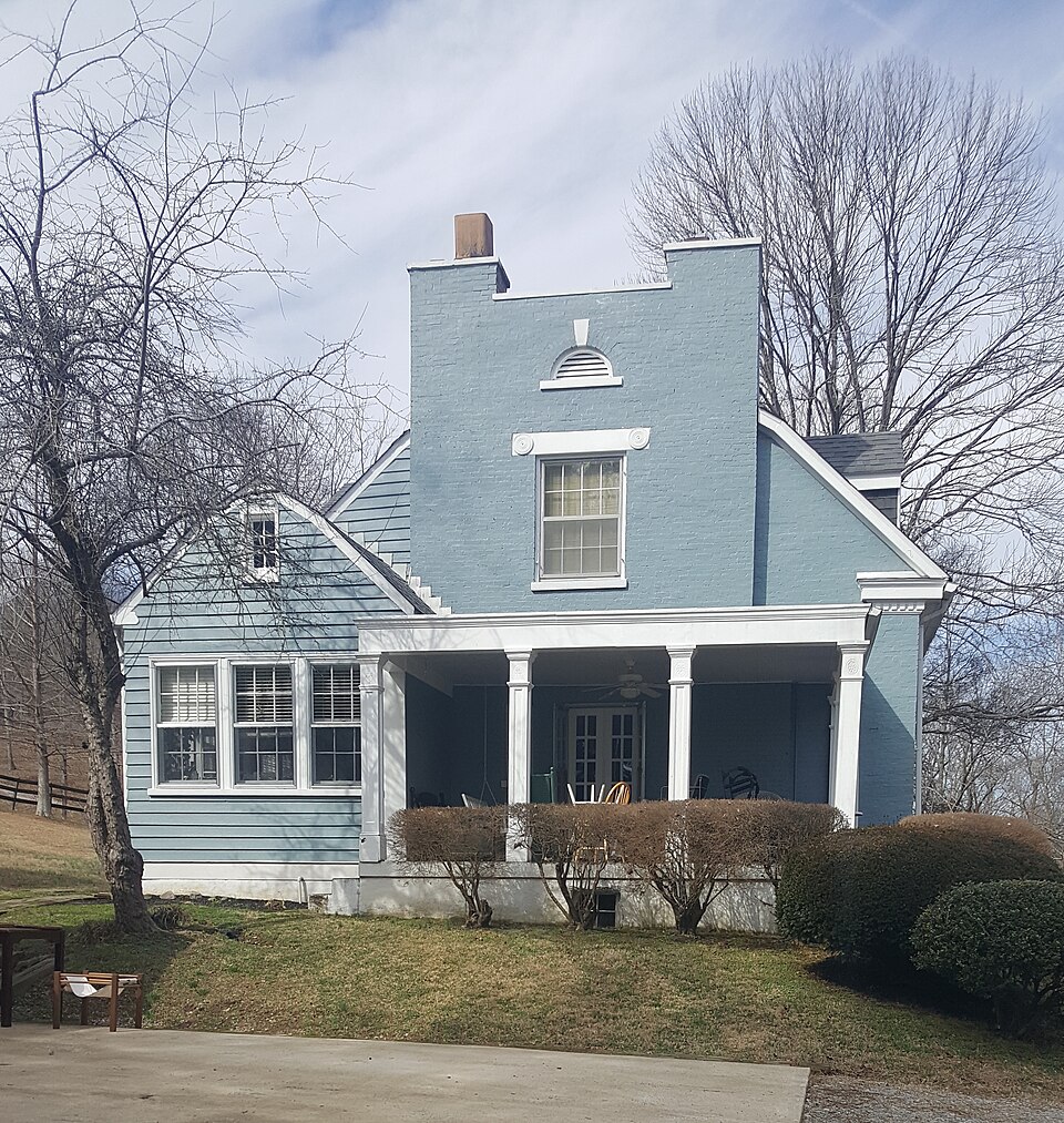
Listed on the National Register of Historic Places in 2006.
One of 204 National Register listings published here for Davidson County · listed in 2006 · category: Building.
Sources: the National Register database, National Park Service · the Wikipedia article
Regional context, not property-specific evidence. The federal wildfire occurrence database lists 5 fires within 5 miles of Wilkinson House between 1998 and 2009, burning about 40 acres in total. None started naturally. None was recorded as arson. Distance is straight-line from the map coordinates, so a fire counted here may appear on a neighbouring settlement's page as well.
| Reported cause | Fires |
|---|---|
| Debris and open burning | 3 |
| Equipment and vehicle use | 1 |
| Smoking | 1 |
The most recent of them, most recent first, with the day each was reported and the service that recorded it.
| Date | Cause | Size | Reported by | Name on the report |
|---|---|---|---|---|
| 29 March 1998 | Debris and open burning | 14 acres | Tennessee Division of Forestry | not named |
| 23 March 2009 | Equipment and vehicle use | 5.0 acres | Tennessee Division of Forestry | METRO FIRE |
| 11 March 2007 | Smoking | 16 acres | Tennessee Division of Forestry | SRILEY ADCOCK |
| 9 December 2006 | Debris and open burning | 5.0 acres | Tennessee Division of Forestry | not named |
| 6 November 1999 | Debris and open burning | under an acre | Tennessee Division of Forestry | not named |
Regional context, not property-specific evidence. The federal mineral resources record lists 1 working within 5 miles of Wilkinson House: 1 prospect. None of them still produces. What was taken out: Zinc, Lead, Fluorine-Fluorite. Distance is straight-line from the map coordinates, so a quarry counted here may appear on a neighbouring settlement's page as well.
| Where | Site | Commodity | Status | Recorded |
|---|---|---|---|---|
| Baker | Zinc, Lead, Fluorine-Fluorite | Prospect |
Regional context, not property-specific evidence. The National Weather Service names Joelton, the town this property stands in, in 31 storm reports between 1996 and 2025: 17 thunderstorm wind, 8 hail, 2 flash flood, 2 tornado. No death or injury is recorded in these reports. Each account below is quoted exactly as the forecast office filed it, from the NOAA Storm Events Database, and each date opens the federal record of that event.
| When | Event | Place named | Harm | What the report says |
|---|---|---|---|---|
| November 2017 | Tornado (EF1) | Joelton | $50,000 | An EF-1 tornado started along Stagner Road just north of Interstate 24 around 1.2 miles northwest of Joelton, blowing down several trees as it moved eastward to Whites Creek Pike. More trees and power lines were blown down on Millken Drive and Margie Drive before the tornado intensified and caused significant roof damage to two homes on Gary Road just south of Union Hill Road. Several power poles were also snapped and trees uprooted in this area. The tornado continued eastward through inaccessible forests blowing down numerous trees before rapidly dissipating about one half mile north of the Clay Lick Road bridge over Interstate 24. The beginning point, start time, end point, and path length of this tornado were updated in July 2018 based on newly available high resolution satellite imagery in Google Earth. |
| July 2025 | Lightning | Joelton | $25,000 | Lightning struck a natural gas substation in Joelton, causing a fire. Damages are a rough estimate. |
| July 2012 | Thunderstorm Wind | Joelton | $25,000 | Steeple and siding was blown off First Baptist Church in Joelton with debris blown into parking lot next door. |
| May 2025 | Thunderstorm Wind | Joelton | $15,000 | Severe thunderstorm winds downed a tree onto a home in the Joelton area. Damages are a rough estimate. |
| November 2017 | Thunderstorm Wind | Joelton | $15,000 | A 3/4 mile wide by 5 mile long downburst caused minor wind damage to 17 homes, 3 churches, an apartment building and several outbuildings along and either side of Old Clarksville Pike from the Mt Zion area in Cheatham County eastward to the Joelton area in Davidson County. Damage included the roof blown off a barn on Johns Road, part of the roof and porch blown off a small home at 7321 Old Clarksville Pike, and a collapsed porch on a home on Old Clarksville Pike at Park Lane. Numerous trees and power lines were also blown down along and near Old Clarksville Pike that blocked roadways. The downburst continued into far northwest Davidson County, where numerous trees were snapped or uprooted along Harper Road, Douglas Road, Bidwell Road, Old Clarksville Pike, and Eatons Creek Road. Six trees were snapped in the yard of a home at 3429 Binkley Road in Joelton. A mobile home suffered minor exterior damage on Old Clarksville Pike and an outbuilding had roof damage on Eatons Creek Road. The downburst ended near I-24 at Whites Creek Pike. Maximum winds were estimated at 75 mph. |
| January 2013 | Tornado (EF0) | Joelton | $10,000 | An EF0 tornado began in Joelton along Harper Road between I-24 and Highway 41 where 3 large oak trees were uprooted and fell in a convergent pattern. The damage path continued east northeast with mostly tree damage. Along Bidwell Road, damage to a roof and barn was observed along with 10 to 15 downed trees. The path of damage crossed Wilkinson Road, Ridgewood Road, and Ivy Point Road where numerous trees were snapped and uprooted before the tornado lifted. |
| July 2012 | Thunderstorm Wind | Joelton | $10,000 | Several trees were snapped and blown down in Joelton. |
| May 2010 | Flash Flood | Joelton | $10,000 | Elaines Salon in Joelton reported about a foot of water standing in their parking lot. |
| July 2010 | Thunderstorm Wind | Joelton | $10,000 | Trees were reported downed on Union Hill Road near Joulton. |
| November 2005 | Thunderstorm Wind | Joelton | $10,000 | Shallow rooted trees were uprooted, and a few trees were snapped. One home had roof damage. The hardest hit area was along Strawberry Hill Rd. |
| June 1997 | Thunderstorm Wind | Joelton | $10,000 | Numerous trees down. A tree fell on top of a house. |
| April 2015 | Thunderstorm Wind | Joelton | $3,000 | Trees were blown down in Joelton. |
| July 2023 | Thunderstorm Wind | Joelton | $1,000 | A #tspotter reported a small tree snapped in Joelton. Damages are a rough estimate. |
| June 2022 | Thunderstorm Wind | Joelton | $1,000 | A 50 foot tall tree was snapped in Joelton. |
| July 2016 | Thunderstorm Wind | Joelton | $1,000 | A picture of a fallen tree in Joelton was posted to the NWS Nashville Facebook page. |
| December 2013 | Thunderstorm Wind | Joelton | $1,000 | A large tree was blown down at Union Hill Road and Whites Creek Pike in Joelton. |
| February 2025 | Hail | Joelton | - | Estimated nickel size hail was reported from a strong thunderstorm northwest of Nashville. |
| March 2023 | Hail | Joelton | - | Estimated quarter inch hail fell from a severe thunderstorm north of Nashville. |
| June 2009 | Funnel Cloud | Joelton | - | Funnel Cloud was observed near Joelton. |
| April 2006 | Hail | Joelton | - | Hail covering the ground in Joelton. |
| January 2005 | Thunderstorm Wind | Joelton | - | Trees were down on Harper Road near Cheatham County. |
| July 2003 | Hail | Joelton | - | Spotter reported quarter size hail on I-24 near the Davidson County and Cheatham county line. |
| July 2001 | Thunderstorm Wind | Joelton | - | Spotter reported trees snapped off. |
| May 1999 | Thunderstorm Wind | Joelton | - | Tree fell on top of a car. |
| May 1998 | Flash Flood | Joelton | - | Car swept off the side of the road on I-24 due to high water. |
| June 1997 | Thunderstorm Wind | Joelton | - | Several trees were blown down. At one point 30,000 customers were without power in Davidson county. |
| March 2012 | Hail | Joelton | - | no account filed |
| March 2012 | Hail | Joelton | - | no account filed |
| March 2012 | Hail | Joelton | - | no account filed |
| June 1996 | Thunderstorm Wind | Joelton | - | no account filed |
| April 1996 | Hail | Joelton | - | no account filed |
No historic map-sheet match is published for this property yet. That does not mean no map exists. This record needs a coordinate-quality review before it can be joined to a sheet boundary. Browse the county's mapped places while that work is pending.
Other National Register properties close enough to walk or drive between, ordered by distance from this one. Both positions come from the same geocoding pass that matched these properties to their map sheets.
| Photograph | Property | Distance | Listed |
|---|---|---|---|
| Abner T. Shaw House | 4.9 miles | 1985 | |
 | Whites Creek Historic District | 6.4 miles | 1984 |
| Cartwright-Moss House | 7.9 miles | 1979 |
| National Archives record | The nomination case file for reference 06001095 in Record Group 79. |
| Wikipedia article | Community-written account of this property, licensed CC BY-SA. |
| Davidson County | All 204 listed properties in this county. |