 Block
From the record
One of 38 National Register listings published here for Sumner County · listed in 2011 · category: Building.
Sources: the National Register database, National Park Service
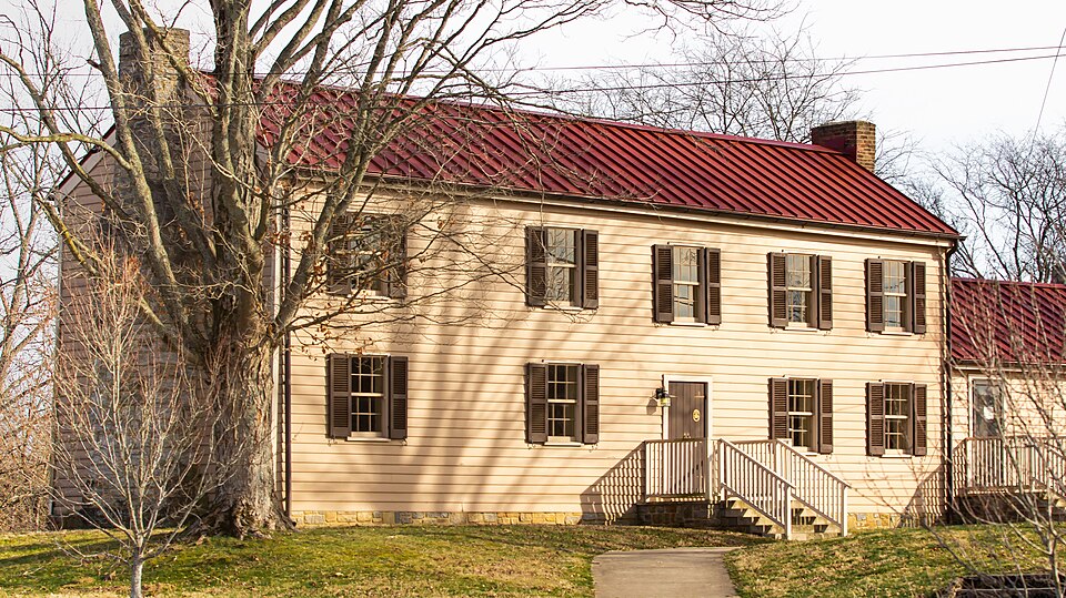
Listed on the National Register of Historic Places in 2011.
One of 38 National Register listings published here for Sumner County · listed in 2011 · category: Building.
Sources: the National Register database, National Park Service
Regional context, not property-specific evidence. The federal wildfire occurrence database lists 15 fires within 5 miles of Douglass-Clark House between 1997 and 2011, burning about 86 acres in total. 1 started naturally. 1 was recorded as arson. Distance is straight-line from the map coordinates, so a fire counted here may appear on a neighbouring settlement's page as well.
| Reported cause | Fires |
|---|---|
| Debris and open burning | 8 |
| Smoking | 2 |
| Missing data/not specified/undetermined | 2 |
| Natural | 1 |
| Misuse of fire by a minor | 1 |
| Arson/incendiarism | 1 |
The most recent of them, most recent first, with the day each was reported and the service that recorded it.
| Date | Cause | Size | Reported by | Name on the report |
|---|---|---|---|---|
| 29 September 2007 | Debris and open burning | 25 acres | Tennessee Division of Forestry | LONG HOLLOW FIRE |
| 24 September 1999 | Smoking | under an acre | Tennessee Division of Forestry | not named |
| 23 September 1999 | Debris and open burning | 30 acres | Tennessee Division of Forestry | not named |
| 15 September 1999 | Smoking | 3.0 acres | Tennessee Division of Forestry | not named |
| 7 August 2006 | Natural | under an acre | Tennessee Division of Forestry | not named |
| 9 March 2009 | Missing data/not specified/undetermined | 1.0 acres | Tennessee Division of Forestry | CUMMING FIRE |
| 9 March 2007 | Debris and open burning | under an acre | Tennessee Division of Forestry | GARRISON RD |
| 8 March 2007 | Debris and open burning | 1.0 acres | Tennessee Division of Forestry | MUD HOLLOW RD |
Regional context, not property-specific evidence. The federal mineral resources record lists 5 workings within 5 miles of Douglass-Clark House: 2 producers, 2 occurrences, 1 past producer. 2 still produce. What was taken out: Stone, Crushed/Broken, Stone, Crushed/Broken, Limestone, General, Uranium, Oil Shale, Uranium. Distance is straight-line from the map coordinates, so a quarry counted here may appear on a neighbouring settlement's page as well.
| Where | Site | Commodity | Status | Recorded |
|---|---|---|---|---|
| Outcrop Sample For Uranium | Uranium, Oil Shale | Occurrence | ||
| Outcrop Sample For Uranium | Uranium, Oil Shale | Occurrence | ||
| Pilot Knob Quarry | Stone, Crushed/Broken, Limestone, General | Producer | Limestone | |
| Gallatin Quarry | Stone, Crushed/Broken | Producer | ||
| Pilot Knob Quarry | Stone, Crushed/Broken | Past Producer |
Regional context, not property-specific evidence. The National Weather Service names Gallatin, the town this property stands in, in 123 storm reports between 1993 and 2026: 69 thunderstorm wind, 42 hail, 8 flash flood, 3 tornado. The reports record 8 deaths and 139 injuries. Each account below is quoted exactly as the forecast office filed it, from the NOAA Storm Events Database, and each date opens the federal record of that event.
| When | Event | Place named | Harm | What the report says |
|---|---|---|---|---|
| April 2006 | Tornado (F3) | Gallatin | 7 killed, 121 hurt, $69,000,000 | This is where the tornado struck hit the hardest in Sumner County. It entered Hendersonville from Goodlettsville at 1312 CST, and struck Gallatin at 1325 CST. An aerial survey determined this tornado had a path length of 22.75 miles from Davidson County and into Sumner County. 7 people died directly as a result of the tornado. One woman, who was 83 years old, died of a heart attack the day the tornado swept through Gallatin, and is considered an indirect death due to the tornado causing her heart attack. All 7 fatalities happened in Gallatin. There was extensive damage to homes and businesses. 700 homes and businesses were damaged or destroyed in Sumner County. The City of Hendersonville had 80 homes destroyed, As a result, Hendersonville city officials are considering installing tornado sirens in the city.Volunteer State Community College in southwest Gallatin was heavily damaged as were several car dealerships across the road. Vol State reopend 10 days after the tornado struck on Monday, April 17. There were about 400 faculty, staff and students on campus at the time the tornado struck. that day. Ms. Angie Jowers, public relations director for the college, stated that having routine tornado safety drills paid off on April 7th. Mr. Steve Doremus, spokesman for the Sumner County Schools, said that all 25,500 students were safe from the tornado because of routine tornado drills done in the county's 42 schools. Vol State school officials placed damage at the campus around $56 million. There was $69 million in damage in Sumner County alone. One estimate for damage done by tornadoes across Middle Tennssee on April 7 was placed at $391 million. Unfortunately, at night, looters came out to Gallatin. A nightly curfew was imposed for a while to curb the looting. The National Guard was called in to help with security matters and debris removal. By May 4, 2006, 23 people were arrested for looting in Gallatin. Several people died inside their homes. A NWS Storm Survey Team discovered that 1/2 million dollar brick homes were not built as well as one might have expected. Cinder blocks were filled with concrete, and boards were nailed to the cinder block as the base for the foundation. The strong winds caused some brick homes to move off the cinder blocks and collapse. This was observed in the Woodhaven Subdivision in Gallatin. |
| December 2019 | Flash Flood | Gallatin | 1 killed | A man reportedly attempted to cross the flood waters of Town Creek from the Town Creek Greenway in Gallatin but was swept away and drowned. His body was discovered in Town Creek near East Broadway Street the next day. |
| May 1999 | Tornado (F2) | Gallatin | 17 hurt, $1,000,000 | The tornado touched down and struck the Rucker Stewart M.S. in the Gallatin city limits, continued northeast and hit the Greenwood Apartments and finally the Gallatin Post Office. The damage to the school and the post office was mainly roof damage. However, the Greenwood Apartments were the hardest hit. 40 families or 100 people were temporarily homeless. 3 apartment buildings were condemned. 17 people were treated at the Sumner Regional Medical Center and released. There were no serious injuries. |
| March 2002 | Lightning | Gallatin | 1 hurt | Bill Haynes, a 24 year old veteran of the Gallatin Fire Department, was answering an emergency call when lightning surged through the telephone line. The jolt threw him back in his chair. Haynes was treated and released from Sumner Medical Center. He was left with a tingling sensation in his arm. The lightning knocked out the telephones and computers at the fire hall and nearby Gallatin City Hall. |
| May 2000 | Thunderstorm Wind | Gallatin | $100,000 | 75 mph wind gusts were measured by a spotter in Gallatin. Numerous trees were blown down countywide. A tree fell on a house at Cottontown. 20 homes around Sumner county received damage. |
| June 2009 | Thunderstorm Wind | Gallatin | $50,000 | Summer County Sheriffs Office reported trees down in the Gallatin area and other parts of Sumner County between 820 PM and 845 PM. |
| February 2008 | Thunderstorm Wind | Gallatin | $50,000 | Cars were overturned and numerous trees were down. |
| July 2004 | Thunderstorm Wind | Gallatin | $50,000 | A 100-year-old silver maple tree came crashing on the front porch of a historic home in the Woodson Terrace Historic District. The home, built in 1898, had no concrete between the blocks so when the tree hit it, it shifted the house off its foundation. |
| May 2012 | Thunderstorm Wind | Gallatin | $30,000 | Multiple trees were downed in Gallatin and the surrounding area. Some of these trees fell on power lines resulting in power loss in certain sections of the city. |
| July 2012 | Thunderstorm Wind | Gallatin | $30,000 | Several trees were downed. Roof damage also occurred, with one roof in a roadway on South Water Avenue. A tree also fell onto a house. The power to the traffic signals was also out in downtown Gallatin. Specific details on the amount of roof damage that occurred along with any damage caused by the tree falling onto a house were unknown. |
| March 1995 | Thunderstorm Wind | Gallatin | $30,000 | Between 12 and 15 homes were damaged. Numerous trees and power lines were knocked down. |
| May 2024 | Thunderstorm Wind | Gallatin | $25,000 | Severe thunderstorm winds downed power poles and broken tree limbs in south Gallatin. Damages are a rough estimate. |
| July 2023 | Thunderstorm Wind | Gallatin | $25,000 | Severe thunderstorm winds downed numerous trees in and around Gallatin, some of which were blocking roadways. Damages are a rough estimate. |
| July 2012 | Thunderstorm Wind | Gallatin | $25,000 | Large tree limbs were blown down resulting in power outages. Roof damage also occured and signs were also blown down. Specific details on what structures sustained roof damage and the amount and type of roof damage were unknown. |
| May 2011 | Thunderstorm Wind | Gallatin | $25,000 | Six to ten roads across the county were closed due to trees and power lines being downed on them. |
| May 2011 | Thunderstorm Wind | Gallatin | $25,000 | Trees were reported blown down county wide. |
| September 1997 | Thunderstorm Wind | Gallatin | $20,000 | Strong thunderstorm winds blew down a large tree. The tree fell across a fence and onto 2 cars in a Sav-A-Lot parking lot. |
| May 2020 | Thunderstorm Wind | Gallatin | $15,830 | Numerous trees were blown down across Gallatin and much of southern Sumner County. |
| April 2025 | Thunderstorm Wind | Gallatin | $10,000 | Severe thunderstorm winds downed a tree onto a home near the Aldis in Gallatin. Damages are a rough estimate. |
| December 2021 | Thunderstorm Wind | Gallatin | $10,000 | Straight line winds damaged several homes and blew down numerous trees along Long Hollow Pike and adjacent side streets between Highway 109 and downtown Gallatin. Winds were estimated up to 70 mph. |
| June 2019 | Flash Flood | Gallatin | $10,000 | Sumner County EMA reported five swift water rescues were conducted across Gallatin, including on Gray Street, Boyers Avenue, Fairgrounds Road, and the intersection of West Main Street at Red River Road. Another swift water rescue was conducted west of the city on New Hope Road. |
| July 2012 | Thunderstorm Wind | Gallatin | $10,000 | Seven trees were downed in Gallatin. |
| April 2011 | Thunderstorm Wind | Gallatin | $10,000 | Several trees were downed along with a traffic light being blown down on State Highway 109 near the intersection with U.S Highway 31. |
| April 2010 | Thunderstorm Wind | Gallatin | $10,000 | Summer county EMA reported telephone poles downed with wires across the road at the 1100 block of liberty lane in Gallatin. |
| June 2005 | Thunderstorm Wind | Gallatin | $10,000 | EMA reported numerous trees down and a roof blown off a house. Power lines were down. One road was closed due to fallen trees. 2 homes had moderate damage. |
| June 1995 | Thunderstorm Wind | Gallatin | $10,000 | Numerous trees and power lines were knocked down. |
| March 2026 | Thunderstorm Wind | Gallatin | $5,000 | Severe thunderstorm winds caused a window to shatter at the Gallatin Civic Center. Damages are a rough estimate. |
| December 2025 | Thunderstorm Wind | Gallatin | $5,000 | Several trees were downed in the Gallatin and Westmoreland areas. Damages are a rough estimate. |
| August 2018 | Thunderstorm Wind | Gallatin | $5,000 | Gallatin Fire Department reported a tree fell on a house and power lines were blown down in Gallatin. |
| June 2016 | Thunderstorm Wind | Gallatin | $5,000 | Gallatin News reported numerous trees down across Gallatin with one falling onto a truck on Perrolee Street. |
| July 2016 | Thunderstorm Wind | Gallatin | $5,000 | Facebook photos showed an outbuilding was blown off its foundation and destroyed. |
| April 2011 | Thunderstorm Wind | Gallatin | $5,000 | Several trees were downed at Long Hollow Golf Course. |
| May 2010 | Thunderstorm Wind | Gallatin | $5,000 | Several large trees were damaged at two homes just northeast of Gallatin. Extent of damage to these large trees were unknown. |
| June 1997 | Thunderstorm Wind | Gallatin | $5,000 | Several trees were blown down. A tin roof was blown off a building. |
| May 2021 | Thunderstorm Wind | Gallatin | $3,000 | Trees were blown down in portions of Gallatin. |
| June 2019 | Thunderstorm Wind | Gallatin | $3,000 | A NWS employee reported trees were blown down in Gallatin. |
| June 2018 | Thunderstorm Wind | Gallatin | $3,000 | Several trees were reportedly blown down across Gallatin. |
| March 2017 | Thunderstorm Wind | Gallatin | $3,000 | WSMV-TV reported large trees blown down in Gallatin. |
| May 2017 | Thunderstorm Wind | Gallatin | $3,000 | A tSpotter Twitter report indicated a tree fell on car on Hull Circle in Gallatin. |
| July 2016 | Thunderstorm Wind | Gallatin | $3,000 | A tSpotter Twitter report indicated a tree was blown down on a house in Gallatin. No injuries. |
| May 2019 | Thunderstorm Wind | Gallatin | $2,000 | Shingles were blown off the roof of a home and heavy outdoor furniture was displaced. |
| May 2015 | Thunderstorm Wind | Gallatin | $2,000 | WKRN-TV reported 2 trees were snapped at a home in Gallatin. |
| June 2010 | Thunderstorm Wind | Gallatin | $1,500 | A tree was blown down and was lying across a county road. Exact name of the county road was unkown. |
| June 2019 | Thunderstorm Wind | Gallatin | $1,000 | Several trees were blown down across Gallatin, including on Joann Street at Broadway. |
| April 2017 | Thunderstorm Wind | Gallatin | $1,000 | A Facebook report indicated a large tree branch was blown down in Gallatin. |
| June 2016 | Thunderstorm Wind | Gallatin | $1,000 | Photo showed a large tree limb snapped in Gallatin. |
| November 2015 | Thunderstorm Wind | Gallatin | $1,000 | WKRN-TV and tSpotter reports via Twitter showed a picture of an uprooted tree in Gallatin. |
| April 2011 | Thunderstorm Wind | Gallatin | $1,000 | A 2.5 foot diameter tree was downed. |
| August 2006 | Flash Flood | Gallatin | $1,000 | Gallatin City Police reported extensive street flooding with some businesses flooded. |
| April 2005 | Flash Flood | Gallatin | $1,000 | Deshea Creek was over the road. |
| December 2004 | Flash Flood | Gallatin | $1,000 | Lower Station Camp road and Calendar Lane were flooded. |
| June 1997 | Thunderstorm Wind | Gallatin | $1,000 | A few power lines were down. |
| June 1995 | Thunderstorm Wind | Gallatin | $1,000 | Two large trees were blown down. |
| September 1996 | Thunderstorm Wind | Gallatin | $1,000 | no account filed |
| April 1993 | Thunderstorm Wind | Gallatin | $500 | A few trees were blown down. |
| January 1996 | Thunderstorm Wind | Gallatin | $100 | no account filed |
| May 2024 | Hail | Gallatin | - | Estimated quarter size hail was reported in Gallatin. |
| May 2024 | Hail | Gallatin | - | Dime size hail was reported west of Gallatin. |
| March 2023 | Hail | Gallatin | - | Estimated quarter size hail fell from a severe thunderstorm in Gallatin. |
| June 2023 | Hail | Gallatin | - | Nickel size hail was reported north-northeast of Gallatin. |
No historic map-sheet match is published for this property yet. That does not mean no map exists. This record needs a coordinate-quality review before it can be joined to a sheet boundary. Browse the county's mapped places while that work is pending.
Other National Register properties close enough to walk or drive between, ordered by distance from this one. Both positions come from the same geocoding pass that matched these properties to their map sheets.
| Photograph | Property | Distance | Listed |
|---|---|---|---|
| Maple Cottage | 2.8 miles | 2000 | |
| Shackle Island Historic District | 3.0 miles | 1978 | |
| Rascoe-Harris Farm | 3.1 miles | 1996 | |
| Mary Felice Ferrell House | 3.3 miles | 1992 | |
 | Oakley | 3.6 miles | 1985 |
 | King Homestead | 4.7 miles | 1978 |
| National Archives record | The nomination case file for reference 11000098 in Record Group 79. |
| Sumner County | All 38 listed properties in this county. |