 Block
From the record
38 National Register listings published here, 1 of them a National Historic Landmark.
Sources: the National Register database, National Park Service
70 topographic sheets cover 105 settlements here, and 38 properties are on the National Register of Historic Places.
38 National Register listings published here, 1 of them a National Historic Landmark.
Sources: the National Register database, National Park Service
Every property in this county listed on the National Register of Historic Places, with the year it was listed and the federal nomination document.
| Photograph | Property | Type | Listed | Reference |
|---|---|---|---|---|
 | Ashcrest Farm | building | 1992 | 92000349 |
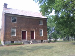 | Bowen-Campbell House | building | 1977 | 77001295 |
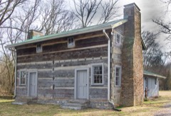 | Bridal House | building | 1982 | 82004059 |
 | Brown-Chenault House | building | 1985 | 85001614 |
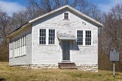 | Cairo Rosenwald School | building | 1996 | 96001359 |
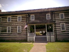 | Castalian Springs | district | 1971 | 71000838 |
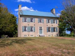 | Cragfont | building | 1970 | 70000618 |
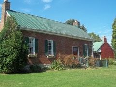 | Daniel Smith Donelson House | building | 1983 | 83003071 |
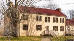 | Douglass-Clark House | building | 2011 | 11000098 |
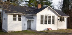 | Durham's Chapel School | building | 2006 | 06000652 |
| Mary Felice Ferrell House | building | 1992 | 92000348 | |
 | Leonard B. Fite House | building | 1982 | 82004061 |
 | Gallatin Commercial Historic District | district | 1985 | 85003369 |
| Gallatin Presbyterian Church | building | 1982 | 82004060 | |
| Greenfield | district | 1990 | 90001579 | |
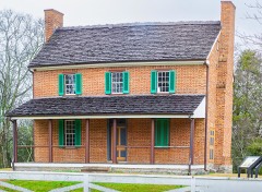 | Hawthorne Hill | building | 2013 | 13000401 |
 | Hazel Path | building | 1984 | 84003713 |
 | James B. Jameson House | building | 1985 | 85002968 |
 | King Homestead | building | 1978 | 78002640 |
| Locust Grove | building | 1979 | 79002484 | |
| Maple Cottage | building | 2000 | 00000229 | |
| Maple Shade | building | 2003 | 03000303 | |
 | Moye Boarding House | building | 2013 | 13000124 |
 | Oakland | building | 1992 | 92000841 |
 | Oakley | building | 1985 | 85001615 |
| Parker-Bryson Historic District | district | 1987 | 87001036 | |
| Parker's Chapel Missionary Baptist Church and Cemetery | district | 2021 | 100007121 | |
| Rascoe-Harris Farm | district | 1996 | 96000772 | |
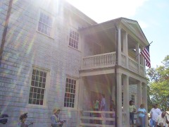 | Rock Castle | building | 1970 | 70000619 |
 | Rosemont | building | 1978 | 78002641 |
| Scattersville Public School | building | 2024 | 100009970 | |
| Shackle Island Historic District | district | 1978 | 78002643 | |
| Trousdale Place | building | 1975 | 75001793 | |
 | Trousdale-Baskerville House | building | 2009 | 09000577 |
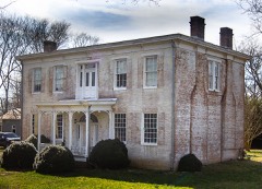 | Wall Spring | building | 1994 | 94000334 |
 | Walnut Grove | building | 1978 | 78002642 |
| Westmoreland Tunnel | structure | 1978 | 78002644 | |
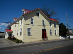 | Williamson and Adams Carriage Factory | building | 1987 | 87000488 |
Every wildfire the federal occurrence database records inside this county: 94 of them, burning about 937 acres. 1 started naturally and 8 were recorded as arson. Each settlement page carries the fires within five miles of it.
| Reported cause | Fires |
|---|---|
| Debris and open burning | 55 |
| Missing data/not specified/undetermined | 8 |
| Arson/incendiarism | 8 |
| Smoking | 6 |
| Misuse of fire by a minor | 5 |
| Equipment and vehicle use | 4 |
| Railroad operations and maintenance | 3 |
| Recreation and ceremony | 3 |
| Natural | 1 |
| Power generation/transmission/distribution | 1 |
The five largest, by the area the report gives. One of them was set deliberately.
| Date | Cause | Size | Reported by | Name on the report |
|---|---|---|---|---|
| 14 November 1999 | Missing data/not specified/undetermined | 100 acres | Tennessee Division of Forestry | not named |
| 23 February 2000 | Arson/incendiarism | 75 acres | Tennessee Division of Forestry | not named |
| 9 February 2001 | Debris and open burning | 65 acres | Tennessee Division of Forestry | not named |
| 9 November 1999 | Smoking | 46 acres | Tennessee Division of Forestry | not named |
| 23 November 2008 | Recreation and ceremony | 35 acres | Tennessee Division of Forestry | not named |
| 22 February 2000 | Misuse of fire by a minor | 35 acres | Tennessee Division of Forestry | not named |
| 23 September 1999 | Debris and open burning | 30 acres | Tennessee Division of Forestry | not named |
| 23 August 2007 | Equipment and vehicle use | 30 acres | Tennessee Division of Forestry | GREENFIELD |
Every settlement page carries the fires within five miles of it - see the settlement index below.
The NOAA Storm Events Database holds 741 reports for this county, causing 16 deaths, 225 injuries and about $117,251,381 in recorded property damage. Each settlement page carries the reports that name it.
| Kind of event | Reports |
|---|---|
| Thunderstorm Wind | 428 |
| Hail | 163 |
| Flash Flood | 72 |
| Tornado | 45 |
| Lightning | 11 |
| Heavy Rain | 10 |
| Flood | 7 |
| Funnel Cloud | 5 |
The most serious of them, by death, then injury, then recorded damage. The accounts are quoted exactly as the forecast office filed them.
| When | Event | Place named | Harm | What the report says |
|---|---|---|---|---|
| April 2006 | Tornado (F3) | Gallatin | 7 killed, 121 hurt, $69,000,000 | This is where the tornado struck hit the hardest in Sumner County. It entered Hendersonville from Goodlettsville at 1312 CST, and struck Gallatin at 1325 CST. An aerial survey determined this tornado had a path length of 22.75 miles from Davidson County and into Sumner County. 7 people died directly as a result of the tornado. One woman, who was 83 years old, died of a heart attack the day the tornado swept through Gallatin, and is considered an indirect death due to the tornado causing her heart attack. All 7 fatalities happened in Gallatin. There was extensive damage to homes and businesses. 700 homes and businesses were damaged or destroyed in Sumner County. The City of Hendersonville had 80 homes destroyed, As a result, Hendersonville city officials are considering installing tornado sirens in the city.Volunteer State Community College in southwest Gallatin was heavily damaged as were several car dealerships across the road. Vol State reopend 10 days after the tornado struck on Monday, April 17. There were about 400 faculty, staff and students on campus at the time the tornado struck. that day. Ms. Angie Jowers, public relations director for the college, stated that having routine tornado safety drills paid off on April 7th. Mr. Steve Doremus, spokesman for the Sumner County Schools, said that all 25,500 students were safe from the tornado because of routine tornado drills done in the county's 42 schools. Vol State school officials placed damage at the campus around $56 million. There was $69 million in damage in Sumner County alone. One estimate for damage done by tornadoes across Middle Tennssee on April 7 was placed at $391 million. Unfortunately, at night, looters came out to Gallatin. A nightly curfew was imposed for a while to curb the looting. The National Guard was called in to help with security matters and debris removal. By May 4, 2006, 23 people were arrested for looting in Gallatin. Several people died inside their homes. A NWS Storm Survey Team discovered that 1/2 million dollar brick homes were not built as well as one might have expected. Cinder blocks were filled with concrete, and boards were nailed to the cinder block as the base for the foundation. The strong winds caused some brick homes to move off the cinder blocks and collapse. This was observed in the Woodhaven Subdivision in Gallatin. |
| February 2008 | Tornado (EF3) | Castalian Spgs | 7 killed, 14 hurt, $10,000,000 | The Castalian Springs Post Office was completely destroyed. There were 85 homes destroyed in Sumner County. ||Also in Castalian Springs, a 180 year-old structure called Wynnewood, lost the top of its structure due to the tornado. The historic log structure served as a stagecoach stop. The structure had 3 chimneys and was 142 feet long, making it the longest log structure in Tennessee.||Officials say it would take 2 years and $6 million to restore Wynnewood. It is Sumner County's sole historic landmark.||Also, 102 trees were lost in the area by the tornado.||The 11-month-old son of Kerri Stowell survived the storm and was found miraculously unharmed in a field across the street from their home in Castalian Springs. Unfortunately, Kerri Stowell was killed in the tornado. ||The tornado directly killed 7 people in Sumner County, and there was one indirect fatality when Mr. Lampkin, age 63, died of a heart attack while seeking shelter in his home. There were 14 people injured in Sumner County. ||This tornado continued into Trousdale and Macon Counties, and also into Kentucky. |
| April 1970 | Tornado (F4) | not stated | 1 killed, 10 hurt, $2,500,000 | no account filed |
| December 2019 | Flash Flood | Gallatin | 1 killed | A man reportedly attempted to cross the flood waters of Town Creek from the Town Creek Greenway in Gallatin but was swept away and drowned. His body was discovered in Town Creek near East Broadway Street the next day. |
| May 1995 | Tornado (F2) | not stated | 28 hurt, $3,000,000 | The tornado first touched down near Goodlettsville and moved northeast. The tornado struck near the Rivergate Mall. At least two dozen business were damaged. Nearly 500 cars were damaged beyond repair at a nearby auto dealership. In Sumner County, 35 apartments were destroyed along with three mobile homes. Several business were damaged. An elementary school in Westmoreland lost a large area of roofing above the gymnasium. The Gallatin Civic Center suffered major damage to its swimming pool. Several high tension towers were bent. Numerous trees and power lines were knocked down. |
| May 1999 | Tornado (F2) | Gallatin | 17 hurt, $1,000,000 | The tornado touched down and struck the Rucker Stewart M.S. in the Gallatin city limits, continued northeast and hit the Greenwood Apartments and finally the Gallatin Post Office. The damage to the school and the post office was mainly roof damage. However, the Greenwood Apartments were the hardest hit. 40 families or 100 people were temporarily homeless. 3 apartment buildings were condemned. 17 people were treated at the Sumner Regional Medical Center and released. There were no serious injuries. |
| November 2002 | Tornado (F2) | Portland | 6 hurt, $500,000 | One person was hospitalized due to injuries from the tornado. The other 5 people were treated and released for their injuries. 7 homes were destroyed, 15 homes had major damage and 14 had minor damage. 5 mobile homes were destroyed, 3 with major damage and 2 with minor damage. One business was destroyed and 3 other businesses were damaged. Several goats and cattle were killed. The heaviest damage was at 404 Glen Have Rd. 2 mobile homes were destroyed and blown off their foundation. 18 outbuildings, 16 barns and 2 churches were damaged.A Chrysler Cirrus LX sedan was flipped and pushed 20 feet. A Ford Ranger truck flipped and rolled 90 feet. A 6 inch by 6 inch board was hurled through the roof of a modular home. Kirby Building Services located at 124 Kirby Road in the industrial park area, sustained 50 percent damage according to the Portland Fire Dept. |
| March 2021 | Thunderstorm Wind | Corinth | 4 hurt, $200,000 | A 4 mile long by 1 mile wide microburst caused severe wind damage east of Portland from Meadows Road northward to the Kentucky border. In the area around Cook Road and Highway 259, dozens of trees were blown down with some falling onto houses and blocking roads. Several homes suffered roof and exterior damage, and numerous barns and outbuildings were damaged or destroyed. Four injuries were reported in this area. Winds were estimated up to 85 mph. |
| February 1956 | Tornado (F3) | not stated | 4 hurt, $25,000 | no account filed |
| March 1955 | Tornado (F2) | not stated | 4 hurt | no account filed |
| November 1984 | Tornado (F1) | not stated | 3 hurt, $25,000 | no account filed |
| May 1980 | Tornado (F1) | not stated | 3 hurt, $25,000 | no account filed |
| June 2016 | Thunderstorm Wind | Shackle Is | 2 hurt, $1,000 | A tree fell onto two men at 1003 Sandy Valley Road. Both men were injured and hospitalized. One suffered a facial laceration and the other man suffered a broken leg. |
| July 1986 | Thunderstorm Wind | not stated | 2 hurt | no account filed |
| December 2023 | Tornado (EF2) | Rockland | 1 hurt, $10,000,000 | This strong EF-2 tornado touched down just to the east of I-24 on Brick Church Lane in Davidson County. There were a few trees down and shingle damage to several homes in this area. The tornado strengthened in the Madison area causing EF-2 damage with winds up to 120-125 mph. The heaviest damage was confined to two areas, off of East Campbell Road as well as Nesbitt Lane. Multiple mobile homes were destroyed on Nesbitt Lane, and this is where three fatalities occurred. Multiple single family homes and a church off of East Campbell Road were missing large sections of their roofs with some exterior walls collapsed. Several metal power poles in the area were bent as well. Nearby, an apartment complex off Palmer Avenue sustained damage. As the tornado moved further northeast, substantial damage was found to houses in a cul-de-sac on Stoney River Lane. Two buildings were toppled and several others damaged in an industrial complex off of Myatt Drive. The tornado then continued across the Cumberland River and Old Hickory Lake, coming onshore again in the immediate dam vicinity. It is this location in which the strongest winds were found, up to 130 miles per hour, due to substantial damage to a grove of hundreds of trees in which all of them were either snapped, uprooted, or missing major branches. The tornado persisted into Hendersonville, downing hundreds of trees and causing roof damage to multiple homes. It damaged many businesses along Main Street. The tornado continued northeast into Gallatin where EF-2 damage with maximum winds of 115 mph was found to a few homes in the Club at Foxland Harbor as we as the Foxland Harbor Golf and Country Club. At this point, the tornado began to weaken though EF-1 damage was found as it crossed Highway 109 and Steam Plant Road. Several trees were still found to be uprooted along with minor roof and shingle damage to a couple of homes as the tornado crossed Hartsville Pike. Scattered trees continued to be blown down along Lauderdale Lane and Homer Scott Road before the tornado crossed Highway 231 into Trousdale County. Trees continued to be blown down on Browning Branch Road and a home suffered significant roof and porch damage on Hawkins Branch Road. Trees continued to be blown down until the tornado lifted near Shephard Hollow Lane. Around 600 homes and businesses were damaged in Sumner County. |
| May 2016 | Flash Flood | Mitchellville | 1 hurt, $3,000,000 | Major flash flooding affected northern and central Sumner County, especially the Portland, Oak Grove, and Bethpage areas. Numerous primary and secondary roads were flooded and closed or even washed out, including Highway 52, Highway 259, William Mack Lane, Harper Road, North Corinth Road, Cora Street, Harper Road, Jim Courtney Road, and Airport Road in Portland; Duffer Hollow Road, Rock Bridge Road, Chipman Road, Red Tuttle Road, Rogana Road, Alexander Road, and Rock Springs Road in Bethpage; and Highway 25 at the Bledsoe Creek Bridge in Castalian Springs. Several homes and businesses were flooded, including several homes in the Richland subdivision on William Mack Lane in Portland. At least 12 water rescues from vehicles and homes were conducted across Sumner County, and one 90 year old man that was rescued was reportedly transported to the Portland ER Hospital with hypothermia. The flooding across Sumner County was reportedly the worst since the historic May 2010 floods. |
| May 2013 | Thunderstorm Wind | Cedar Grove | 1 hurt, $250,000 | Severe gust front winds caused a large road construction crane to collapse onto a car that was driving on the highway 109 bridge over the Cumberland River about 2 miles south of Gallatin. The car had two occupants. One was hospitalized with minor injuries. The other was uninjured. |
| June 2009 | Thunderstorm Wind | Bethpage | 1 hurt, $50,000 | A fireworks tent at Bethpage was pulled up and a women working the stand sustained injury. Details of the extent of any injuries was unkown. |
| May 2003 | Thunderstorm Wind | Castalian Spgs | 1 hurt | Broadcast media reported one mobile home was overturned, and one person was injured. The mobile home was swept off its foundation, landed upside down about 200 feet away. It was one of 4 mobile homes that were damaged or destroyed on Governor Hall Rd. |
| March 2002 | Lightning | Gallatin | 1 hurt | Bill Haynes, a 24 year old veteran of the Gallatin Fire Department, was answering an emergency call when lightning surged through the telephone line. The jolt threw him back in his chair. Haynes was treated and released from Sumner Medical Center. He was left with a tingling sensation in his arm. The lightning knocked out the telephones and computers at the fire hall and nearby Gallatin City Hall. |
| July 2001 | Lightning | Oak Grove | 1 hurt | A woman was picking blackberries near her home when lightning struck a tree about 20 feet from where she stood. The current travelled across the ground and injured her. She was taken to Sumner Region Medical Center and listed in good condition. |
| July 2016 | Flash Flood | Mitchellville | $5,000,000 | Major flash flooding affected much of Sumner County, especially in and near Cottontown, Bethpage, Hendersonville, Gallatin, and Castalian Springs, with numerous homes, businesses, vehicles and roads damaged by flooding. TEMA reported 30 homes were damaged and 4 bridges severely damaged by the flash flooding. Homes were flooded in locations such as Tyree Springs Road in Hendersonville, where residents were trapped by flood waters; Stoneridge Farms Apartments at 2325 Nashville Pike in Gallatin; and on Old Douglas Road in Gallatin, where one home was inundated by three feet of water. Businesses that were flooded included Long Hollow Nursery around 6 miles west of Gallatin. Roads that were flooded and closed in Hendersonville included Lower Station Camp Creek Road between Saundersville Road and Jenkins Lane, Indian Lake Road and Drakes Creek Road at Stop Thirty Road. In Cottontown, roads that were impassable due to flood waters included Bugg Hollow Road where Briggance Branch and Station Camp Creek flooded the roadway, and Pee Dee Branch Road at Upper Station Camp Creek Road. Other flooded roadways were Old Douglas Road in Gallatin, Old Hopewell Road near Lauderdale Lane in Bethpage which was washed out, Deshea Creek Road northeast of Gallatin which was washed out, and Saddle Club Road in Westmoreland which was also washed out. One man had to be rescued from clinging to a tree after his vehicle was washed away in flood waters on Liberty Lane about 5 miles northwest of Gallatin. Another man was rescued after driving into flood waters in Castalian Springs. No injuries or fatalities were reported. |
| May 2024 | Flash Flood | Liberty | $2,000,000 | Numerous reports of major flash flooding were received across Sumner County, including Gallatin. Impassable roads included Upper Station Creek Road, Liberty Lane, and Long Hollow Pike. Long Hollow Gardens and Long Hollow Golf Course were also reported to be underwater. A house along Long Hollow Gardens was also inundated with flood waters. Life-threatening flash flooding across Sumner County prompted the issuance of a Flash Flood Emergency for the county. Damages are a rough estimate. |
| May 2024 | Flash Flood | Rockland | $2,000,000 | Numerous reports of major flash flooding were received across Sumner County, including Hendersonville. Impassable roads included Stop Thirty Road, Drakes Creek Road, Indian Lake Boulevard, Old Shackle Island Road, and Anderson Road. Life-threatening flash flooding across Sumner County prompted the issuance of a Flash Flood Emergency for the county. Damages are a rough estimate. |
| December 2021 | Tornado (EF1) | Old Hickory | $1,500,000 | An EF-1 tornado touched down in Old Hickory on Martingale Drive and moved northeast across Fowler Street, Orchard Drive, Wilmington Street, Richmond Street, 4th Street, and Jones Circle, uprooting several large trees, causing roof damage to multiple homes, and damaging outbuildings. The tornado then moved across Old Hickory Lake and downed power lines and trees from Walton Ferry to Sanders Ferry Road in Hendersonville. The heaviest damage occurred on Private Drive, Cumberland Hills Drive and Lake Valley Road where numerous trees were snapped or uprooted and homes received significant roof damage. The tornado continued east, crossing Old Hickory Lake once again and downing trees and power lines on Carter Lane in north Mt. Juliet. The storm weakened and lifted on Saundersville Ferry Road near Crosswinds Drive. Total path length of this tornado was 6.82 miles. |
| August 2013 | Flash Flood | Old Hickory | $500,000 | Flash flooding affected much of the southwest portion of Sumner County after 5 to 7 inches of rain fell during the morning hours on August 8. Six homes were flooded in the Walton Trace Road area of Hendersonville. Numerous roadways were also flooded and closed. |
| May 2010 | Tornado (EF1) | Rockland | $450,000 | The tornado lifted for several miles into Sumner County and then touched down again near the intersection of Forest Retreat Road and Hunts Lane, just north of Highway 386. Damage consisted of hundreds of snapped hardwood trees and minor roof damage was then continuous to the northeast for 5 miles.||The most significant damage, high end EF1, occurred on Kimber Lane just off highway 258. An older home was picked up partially off its foundation and suffered significant roof damage. The last evidence of damage was near the intersection of Latimer Circle and Long Hollow Pike.||Maximum wind speeds in the tornado were estimated to be around 105 mph. |
| July 2015 | Lightning | Saundersville | $300,000 | Lightning struck a home on Skyview Drive near Bluegrass Drive. The resulting fire destroyed the home. |
| July 2016 | Lightning | Millersville | $250,000 | A home on Mansker Drive in Millersville was struck by lightning and completely destroyed by the resulting fire. |
| May 1984 | Tornado (F1) | not stated | $250,000 | no account filed |
| May 1984 | Tornado (F2) | not stated | $250,000 | no account filed |
| April 1955 | Tornado (F2) | not stated | $250,000 | no account filed |
| January 2013 | Tornado (EF0) | Avondale | $225,000 | An EF0 tornado touched down near the intersection of Highway 31 and Shute Lane in Hendersonville then traveled across southern areas of Gallatin before lifting near Bledsoe Creek State Park. Hundreds of trees were snapped or uprooted all along the path with some trees falling on homes and outbuildings. The roof and one side of a mobile home was blown off near the beginning of the path. Several homes had minor roof damage on Drayton Downs, Gordon Crossing, and Nogs Garden roads. The most significant damage occurred in the Fairview Plantation and Baypoint subdivisions where dozens of homes suffered roof and siding damage on Jacobs Drive, Chloe Drive, Browns Lane, Elizabeth Court, Woodlake Drive, Willowlake Drive, and Inneswood Drive. More homes were damaged on Aqua Drive and Lock 4 Road, and several docks at the Gallatin Marina were damaged. Additional minor roof damage occurred to homes along the path until the tornado lifted. |
| November 2013 | Tornado (EF0) | Portland | $200,000 | An NWS Storm Survey Team concluded an EF-0 tornado touched down on the northwest side of Portland, tearing the roof off of a Fire Hall Building. The tornado, with maximum winds of 70 mph, also did minor damage to a church. Several trees were also snapped along the path of the tornado. |
| May 2009 | Flash Flood | White House | $200,000 | People stranded in cars and homes were flooded in Walnut Grove and the surrounding areas. |
| April 2009 | Tornado (EF1) | Johnsons Xrds | $200,000 | Damage occurred near the intersection of Highways 25 and 76. Four frame homes, per newspaper report, and a mobile home suffered significant roof damage along Creekmore Road. Numerous trees were snapped or uprooted. Per newspaper report, numerous power lines were downed.|The path length of the tornado was 0.6 mile with a maximum path width of 50 yards. The damage was rated EF-1 in intensity, with maximum wind speeds around 100 mph. |
| April 1998 | Tornado (F2) | Cottontown | $200,000 | The tornado downed trees, power lines and took off roofs to many homes. Areas just south of Cottontown were hardest hit. Homes were also damaged just north of Gallatin on RT 109 and Douglas Lane. |
| January 2013 | Tornado (EF0) | Millersville | $120,000 | An EF0 tornado moved out of Davidson County into Sumner County at Millersville. Numerous homes suffered minor roof and exterior damage along a narrow path across Williamson Road, Jesse Brown Drive, Cimmaron Drive, and other adjacent streets. Crossing I-65, a few more homes received minor roof damage on Lewis Drive. The tornado continued eastward with additional minor damage to homes along Patton Branch Road and Hogans Branch Road. Near the intersection of Tyree Springs Road and Sandy Valley Road, the tornado destroyed two garage buildings. Some more homes had minor roof damage along the path until the tornado lifted along Upper Station Camp Road. Dozens of trees were snapped and uprooted all along the path. |
| August 2024 | Thunderstorm Wind | Peytona | $100,000 | Severe thunderstorm winds destroyed a boat dock in the Foxland Harbor area. Damages are a rough estimate. |
| June 2024 | Flash Flood | White House | $100,000 | Heavy rain fell across portions of Sumner County during the early morning hours of June 30th. CoCoRaHS observers in this area measured 3 to 3.5 inches of rain which caused flooding. The White House area was hardest hit with flooding. In White House, roads that were flooded included Highway 31, Rolling Acres Drive, Union Road, Winchester Court, and Autumn Wood Drive. Along Autumn Wood Drive, one home was flooded, and a car was overturned. Homes were also flooded on Winchester Court and Rolling Acres Drive. Damages are a rough estimate. |
| July 2023 | Thunderstorm Wind | Hendersonville | $100,000 | Severe thunderstorm winds downed numerous trees and powerlines across southwestern Sumner County. One of these trees fell onto and crushed a house along Raintree Drive in Hendersonville. No injuries or fatalities were reported. Damages are a rough estimate. |
| July 2016 | Flash Flood | Pleasant Grove | $100,000 | Significant flash flooding affected eastern Sumner County, especially the Bransford, Westmoreland and Bethpage areas along the Bledsoe Creek watershed, with several homes, buildings, vehicles and roads damaged by flooding. Roads that were flooded and closed included Phillips Hollow Road, Highway 31E at Deshea Creek, Haze Hyde Hollow Road, Pumping Station Road, Wolf Hill Road, and Old Wolf Hill Road. Four water rescues were conducted, including four people who were rescued from a flooded home at 125 Phillips Hollow Road. An unoccupied car at the home was also swept away in the flood waters. Several homes, farm buildings, and a church were flooded or surrounded by flood waters along Highway 31E near Wolf Hill Road in the Bransford community, as well as along Pumping Station Road in Westmoreland. No injuries or fatalities were reported. |
| July 2009 | Tornado (EF1) | Bransford | $100,000 | A few hundred trees were either snapped off or uprooted. Power lines were snapped also in the area. A few homes sustained very light damage with windows blown off. Some homes had shingles blown off. One large barn was flattened. Several outbuildings and carports were also damaged. Winds were estimated between 95 MPH and 100 MPH. |
| May 2000 | Thunderstorm Wind | Gallatin | $100,000 | 75 mph wind gusts were measured by a spotter in Gallatin. Numerous trees were blown down countywide. A tree fell on a house at Cottontown. 20 homes around Sumner county received damage. |
| March 1997 | Flash Flood | Westmoreland | $80,000 | A few roads were washed out near Westmoreland. |
| February 2011 | Thunderstorm Wind | Hendersonville | $75,000 | In south Hendersonville, a heavily forested subdivision experienced tree damage. At least 100 large hardwood trees were uprooted, including a few snapped. Trees that had fallen had damaged some roofs and vehicles. Some loss of shingles also noted on house roofs. |
| January 2013 | Tornado (EF0) | Castalian Spgs | $65,000 | An EF0 tornado touched down near the intersection of Highway 25 and Harsh Lane directly impacting an apple market with minor roof damage. Several trees were snapped and uprooted with several homes receiving minor roof damage along the path until the tornado lifted one half mile north of the intersection of Governor Hall Road and Homer Scott Road. |
| April 2025 | Thunderstorm Wind | Rockland | $50,000 | Severe thunderstorm winds caused major roof damage to buildings along West Main Street in Hendersonville. Metal siding was reported to be piled up in front of Red Rooster Cafe. Damages are a rough estimate. |
| April 2025 | Thunderstorm Wind | Shackle Is | $50,000 | Severe thunderstorm winds destroyed a barn in north Hendersonville. Damages are a rough estimate. |
| June 2025 | Flash Flood | Pleasant Vly | $50,000 | Heavy rain in Sumner County led to flash flooding at Martin Lane and Bowling Branch Road in the Walnut Grove area, likely caused by the nearby creek overfilling its banks. Multiple vehicles were stranded with water rescues needed. Damages are a rough estimate. |
| May 2024 | Thunderstorm Wind | Mitchellville | $50,000 | NWS storm survey found a large 1.5 mile wide by 11 mile long downburst that blew down dozens of trees and power lines across northern Sumner County, from west of Mitchellville to the Kentucky border north of Westmoreland. Some trees fell onto homes causing substantial damage. Max winds were estimated up to 75 mph. Damages are a rough estimate. |
| February 2019 | Flash Flood | Millersville | $50,000 | Over 30 swift water rescues were conducted across Sumner County, mainly in southern parts of the county. Mary's Magical Place, a special needs park in Hendersonville at Highway 386 and Indian Lake Boulevard, was damaged by rushing flood waters from Drakes Creek and closed for several weeks for repairs. |
| May 2011 | Thunderstorm Wind | Kansas | $50,000 | A National Weather Service surveyed tree damage at 1291 Gibbs Lane and found two dozen trees were snapped or uprooted and two dozen more had large limbs snapped. Winds were estimated to be between 75 to 80 mph. |
| May 2010 | Flash Flood | Rockland | $50,000 | Flooding of Drakes Creek Park reported by Hendersonville Police and Vietnam Veterans Highway also has standing water near the Sumner-Davidson County Line. |
| August 2010 | Flash Flood | Trousdale | $50,000 | Numerous roads were closed due to flooding in Gallatin.||Newspapers reported that seven people were rescued during the flash flooding in Gallatin. |
| June 2009 | Thunderstorm Wind | Gallatin | $50,000 | Summer County Sheriffs Office reported trees down in the Gallatin area and other parts of Sumner County between 820 PM and 845 PM. |
| July 2009 | Thunderstorm Wind | Graball | $50,000 | Trees and power lines were downed across the northern portion of the county. |
| February 2008 | Thunderstorm Wind | Gallatin | $50,000 | Cars were overturned and numerous trees were down. |
| July 2004 | Thunderstorm Wind | Gallatin | $50,000 | A 100-year-old silver maple tree came crashing on the front porch of a historic home in the Woodson Terrace Historic District. The home, built in 1898, had no concrete between the blocks so when the tree hit it, it shifted the house off its foundation. |
| August 2003 | Thunderstorm Wind | Hendersonville | $50,000 | Trees and power lines were down. There was roof damage to the Nannie Berry Elementary School. A portion of the roof collapsed. A 36,000 square-foot section of the roof over 4 classrooms was ripped off. Estimated damage to the school was at $50,000. Nearby to the elementary school, straight line winds also destroyed the scoreboard to the Ellis Middle School. |
The Survey's mineral resources record lists 25 workings inside this county. 6 still produce and 19 are closed or unrecorded. Each settlement page carries the workings within five miles of it.
| Commodity | Workings |
|---|---|
| Stone, Crushed/Broken | 8 |
| Uranium, Oil Shale | 7 |
| Uranium | 6 |
| Oil Shale | 6 |
| Stone, Crushed/Broken, Limestone, General | 3 |
| Limestone, General | 1 |
The least common of them first, because a county's hundredth gravel pit says nothing its first ten did not.
| Where | Site | Commodity | Status | Recorded |
|---|---|---|---|---|
| Ralph Rogers and Company Quarry | Limestone, General | Past Producer | Sedimentary | |
| Goodlettsville Plant #503 | Stone, Crushed/Broken, Limestone, General | Producer | Limestone | |
| Pilot Knob Quarry | Stone, Crushed/Broken, Limestone, General | Producer | Limestone | |
| Sumner County Quarry | Stone, Crushed/Broken, Limestone, General | Producer | Limestone | |
| Outcrop Sample For Uranium | Uranium, Oil Shale | Occurrence | ||
| Outcrop Sample For Uranium | Uranium, Oil Shale | Occurrence | ||
| Outcrop Sample For Uranium | Uranium, Oil Shale | Occurrence | ||
| Outcrop Sample For Uranium | Uranium, Oil Shale | Occurrence | ||
| Outcrop Sample For Uranium | Uranium, Oil Shale | Occurrence | ||
| Outcrop Sample For Uranium | Uranium, Oil Shale | Occurrence | ||
| Outcrop Sample For Uranium | Uranium, Oil Shale | Occurrence | ||
| Outcrop Sample For Uranium | Uranium, Oil Shale | Occurrence | ||
| Outcrop Sample For Uranium | Uranium, Oil Shale | Occurrence | ||
| Outcrop Sample For Uranium | Uranium, Oil Shale | Occurrence | ||
| Outcrop Sample For Uranium | Uranium, Oil Shale | Occurrence | ||
| Outcrop Sample For Uranium | Uranium, Oil Shale | Occurrence | ||
| Outcrop Sample For Uranium | Uranium, Oil Shale | Occurrence | ||
| Gallatin Quarry | Stone, Crushed/Broken | Producer | ||
| Goodlettsville Plant #503 | Stone, Crushed/Broken | Producer | ||
| Millersville Plant | Stone, Crushed/Broken | Past Producer | Limestone | |
| Millersville Plant | Stone, Crushed/Broken | Past Producer | ||
| Pilot Knob Quarry | Stone, Crushed/Broken | Past Producer | ||
| Ralph Rogers & Company Quarry - Oak | Stone, Crushed/Broken | Past Producer | ||
| Sumner County Quarry | Stone, Crushed/Broken | Past Producer | ||
| Sumner County Rock | Stone, Crushed/Broken | Producer |
Named settlements recorded in the Geographic Names Information System, each with the topographic sheets covering it. Villages, hamlets and abandoned places alike. Each is shown with the nearest named watercourse or landform and the survey quadrangle it falls on.
District 5 · 37022 · Near Phillips Hollow · Turners Station quadrangle
10 sheets, 1931 to 1985
District 18 · 37075 · Near Mansker Island · Goodlettsville quadrangle
15 sheets, 1903 to 1984
District 21 · 37075 · On Drakes Creek · Hendersonville quadrangle
13 sheets, 1903 to 1984
District 4 · 37148 · Near Belcher Hollow · Portland quadrangle
11 sheets, 1942 to 1985
District 5 · 37148 · On West Prong Caney Fork Creek · Fountain Head quadrangle
11 sheets, 1931 to 1985
District 20 · 37075 · On Drakes Creek · Hendersonville quadrangle
13 sheets, 1903 to 1984
District 17 · 37075 · On Madison Creek · Goodlettsville quadrangle
15 sheets, 1903 to 1984
District 16 · 37072 · On East Fork Slaters Creek · Goodlettsville quadrangle
15 sheets, 1903 to 1984
District 6 · 37031 · Near Ford Island (historical) · Hunters Point quadrangle
10 sheets, 1942 to 1994
District 16 · 37072 · On East Fork Slaters Creek · Goodlettsville quadrangle
15 sheets, 1903 to 1984
District 14 · 37075 · On Robertson Branch · White House quadrangle
13 sheets, 1903 to 1984
No longer a settlement
District 7 · 37066 · Near Union Hill · Gallatin quadrangle
10 sheets, 1942 to 1984
No longer a settlement
District 2 · 37148 · On Dry Fork Creek · Fountain Head quadrangle
11 sheets, 1931 to 1985
District 1 · 37186 · Near Gilliam Hollow · Westmoreland quadrangle
10 sheets, 1931 to 1985
District 14 · 37048 · On Cedarcroft Branch · Portland quadrangle
11 sheets, 1942 to 1985
District 1 · 37022 · Near Keen Hollow · Turners Station quadrangle
10 sheets, 1931 to 1985
District 12 · 37066 · On Liberty Branch · Cottontown quadrangle
13 sheets, 1903 to 1994
No longer a settlement
District 5 · 37022 · Near Buttermilk Hollow · Fountain Head quadrangle
11 sheets, 1931 to 1985
District 19 · 37075 · Near Mansker Island · Goodlettsville quadrangle
15 sheets, 1903 to 1984
District 24 · 37075 · Near Hutlet Hollow · Hendersonville quadrangle
13 sheets, 1903 to 1984
District 6 · 37066 · On Dry Fork · Bethpage quadrangle
8 sheets, 1942 to 1994
No longer a settlement
District 12 · 37066 · On Shaw Branch · Cottontown quadrangle
13 sheets, 1903 to 1994
No longer a settlement
District 17 · 37075 · On Center Point Branch · Goodlettsville quadrangle
15 sheets, 1903 to 1984
District 14 · 37048 · Near Chestnut Ridge · Cottontown quadrangle
13 sheets, 1903 to 1994
District 15 · 37188 · On Jones Branch · White House quadrangle
13 sheets, 1903 to 1984
No longer a settlement
The vanished settlements of Sumner County: the places named above that are no longer on the map.