
BlockBefore
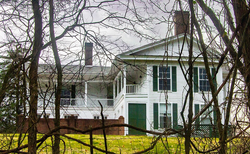
Photograph of Harris-Holden House
Photograph by rossograph, CC BY-SA 4.0. Via Wikimedia Commons.

Harris-Holden House

Built in 1860. Listed on the National Register of Historic Places in 1975.

From the record

“The Harris-Holden House is a historic house on a former plantation in Lincoln County, Tennessee. During the American Civil War of 1861-1865, the Union Army looked for victuals in the house.”

Wikipedia article Harris-Holden House, CC BY-SA 4.0.

One of 17 National Register listings published here for Lincoln County · listed in 1975 · category: Building · built in 1860.

Sources: the Wikipedia article · the National Register database, National Park Service

The listing

  • What is counted as historic. The nomination lists 2 buildingss as contributing to the listing.
  • Address. E of Howell on Daves Hollow Rd., Howell, 37076
  • When was it listed? March 1975
  • Category. building
  • When was it built? 1860
  • National Register reference number. 75001766 - assigned by the National Park Service when the property was listed.

Storms near this property

19 since 1997

Regional context, not property-specific evidence. The National Weather Service names Howell, the town this property stands in, in 19 storm reports between 1997 and 2025: 11 thunderstorm wind, 4 hail, 2 flash flood, 1 tornado. No death or injury is recorded in these reports. Each account below is quoted exactly as the forecast office filed it, from the NOAA Storm Events Database, and each date opens the federal record of that event.

WhenEvent Place namedHarm What the report says
August 2011Thunderstorm WindHowell$75,000Numerous trees and power lines were downed by a line of severe thunderstorms in the county. The locations around Fayetteville Tennessee where the most concentrated thunderstorm wind damage occurred included: Lewisburg highway, North Main Street, Kidd Highway, and Clay and Oak Streets.
May 2003Thunderstorm WindHowell$50,000Newspaper story reported one house was lost on Patton Hollow Road of U.S. Highway 431. 60 to 100 trees were blown down. One horse had to be put down because his leg was cut off to the bone.
February 2011Thunderstorm WindHowell$6,000Trees were blown down on Lewisburg Highway.
December 2025Thunderstorm WindHowell$1,000A tree was reported down along 12 Old Schoolhouse road.
December 2025Thunderstorm WindHowell$1,000A tree was reported down near the intersection of Lewisburg highway and Davis Hallow road.
July 2023Thunderstorm WindHowell$1,000A large tree was knocked down across the road blocking both lanes at 119 Brown Teal Road. Time estimated by radar.
July 2023Thunderstorm WindHowell$1,000A large tree was knocked down blocking both lanes of the road at 362 South Fishing Ford Road. Time estimated by radar.
May 2022Thunderstorm WindHowell$1,000A tree was reported down on Lewisburg Highway.
June 2018Thunderstorm WindHowell$500A tree was knocked down onto a power line on March Mill Road near Fayetteville.
February 2022FloodHowell-Brown Teal Road closed due to flooding from Cane Creek. Depth of water unknown.
September 2021Flash FloodHowell-Brown Teal Road closed due to flash flooding. Time estimated.
March 2017HailHowell-Quarter sized hail was reported.
November 2013Tornado (EF0)Howell-A brief EF-0 tornado with peak winds up to 85 mph touched down just west of Haysland Road, about 6 miles northwest of Fayetteville near Howell. The front porch of a small one-story residence was lifted up, taking with it, a large portion of a metal roof. Debris from the roof and porch was thrown about 50 yards across Haysland Road. Two small cedar trees were snapped (one near its base) just north of the home. Just east of this point across Haysland Road, two smaller trees were snapped near their bases and a small portion of vinyl siding was stripped along the windward facing side of a two-story house.||The tornado brieflly lifted before producing additional damage near the intersection of Brown Teal Road and March Mill Road. At one residence off Brown Teal Road, the roof from a small wood barn was completely lifted and thrown in several directions. A two by four piece of wood became a projectile and smashed into the house, leaving a small hole. At the next house east (corner of Brown Teal Road and March Mill Road), several Bradford pear trees (up to 1 foot in diameter) were snapped near the base. A carport attached to the southwest side of a single wide manufactured home was lifted and crushed. A few metal roof panels from this home were lifted off or peeled back. Some of this debris was thrown several hundred yards east of this point.
July 2013Flash FloodHowell-Deer Trace Road was closed due to high water.
March 2012HailHowell-Hail up to quarter-sized was reported in Howell.
April 2009HailHowell-Cocorahs observer reported quarter size hail in the Howell community.
March 2006Thunderstorm WindHowell-Numerous trees were blown down.
May 2003Thunderstorm WindHowell-Law enforcement reported power poles were damaged.
November 1997HailHowell-Dime size hail reported by local law enforcement.

Every storm recorded in Lincoln County

Map coverage status

No historic map-sheet match is published for this property yet. That does not mean no map exists. This record needs a coordinate-quality review before it can be joined to a sheet boundary. Browse the county's mapped places while that work is pending.

Sources for this property

National Archives recordThe nomination case file for reference 75001766 in Record Group 79.
Wikipedia articleCommunity-written account of this property, licensed CC BY-SA.
Lincoln CountyAll 17 listed properties in this county.

Provenance

  • Listing record. National Park Service National Register of Historic Places, listed-properties dataset, current to 2026-05-22.
  • Map join. Address geocoded through the United States Census geocoder, then tested against the published boundary of every sheet in the USGS Historical Topographic Map Collection.
  • How this page is made. Listing fields come from federal records; map-sheet coverage is a labelled coordinate-to-boundary calculation, not a source-field claim.
  • Storms. NOAA National Centers for Environmental Information, Storm Events Database https://www.ncei.noaa.gov/stormevents/ A work of the United States government, no copyright under 17 U.S.C. 105. Narratives are quoted verbatim from the National Weather Service report and are not edited or summarised.