 Block
From the record
17 National Register listings published here.
Sources: the National Register database, National Park Service
84 topographic sheets cover 79 settlements here, and 17 properties are on the National Register of Historic Places.
17 National Register listings published here.
Sources: the National Register database, National Park Service
Every property in this county listed on the National Register of Historic Places, with the year it was listed and the federal nomination document.
| Photograph | Property | Type | Listed | Reference |
|---|---|---|---|---|
 | Borden Powdered Milk Plant | building | 1988 | 88001060 |
 | Childress House | building | 1982 | 82003985 |
 | Isaac Conger House | building | 1973 | 73001807 |
 | Hugh Bright Douglas House | building | 1982 | 82003986 |
| Greer-Gill Farm | district | 2022 | 100007917 | |
| Harms Mill Hydroelectric Station | district | 1990 | 90001007 | |
 | Harris-Holden House | building | 1975 | 75001766 |
| Kelso Bowstring Arch Truss Bridge | structure | 1983 | 83003046 | |
 | Lincoln County Poor House Farm | building | 1985 | 85001511 |
 | McDonald-Bolner House | building | 1984 | 84003579 |
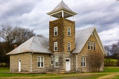 | Mimosa School | building | 1983 | 83003047 |
 | Mount Zion Missionary Baptist Church | building | 2000 | 00000731 |
| Mulbery-Washington-Lincoln Historic District | district | 1984 | 84003580 | |
| Petersburg Historic District | district | 1985 | 85002753 | |
| South Elk Street Historic District | district | 1989 | 89000127 | |
 | St. Paul African Methodist Episcopal Church | building | 2003 | 03001003 |
 | Whitaker-Motlow House | building | 2011 | 11000807 |
Every wildfire the federal occurrence database records inside this county: 959 of them, burning about 3,566 acres. 8 started naturally and 89 were recorded as arson. Each settlement page carries the fires within five miles of it.
| Reported cause | Fires |
|---|---|
| Debris and open burning | 629 |
| Arson/incendiarism | 89 |
| Equipment and vehicle use | 75 |
| Missing data/not specified/undetermined | 65 |
| Smoking | 47 |
| Misuse of fire by a minor | 19 |
| Natural | 8 |
| Recreation and ceremony | 8 |
| Power generation/transmission/distribution | 7 |
| Other causes | 6 |
| Fireworks | 4 |
| Railroad operations and maintenance | 2 |
The five largest, by the area the report gives. One of them was set deliberately.
| Date | Cause | Size | Reported by | Name on the report |
|---|---|---|---|---|
| 27 March 1999 | Debris and open burning | 91 acres | Tennessee Division of Forestry | not named |
| 23 February 2001 | Arson/incendiarism | 75 acres | Tennessee Division of Forestry | not named |
| 10 February 2007 | Debris and open burning | 74 acres | Tennessee Division of Forestry | HAYSLAND RD |
| 31 October 1999 | Missing data/not specified/undetermined | 65 acres | Tennessee Division of Forestry | not named |
| 27 March 1999 | Debris and open burning | 60 acres | Tennessee Division of Forestry | not named |
| 21 February 2009 | Debris and open burning | 51 acres | Tennessee Division of Forestry | STONBORO |
| 31 October 1999 | Railroad operations and maintenance | 50 acres | Tennessee Division of Forestry | not named |
| 10 March 2001 | Debris and open burning | 50 acres | Tennessee Division of Forestry | not named |
Every settlement page carries the fires within five miles of it - see the settlement index below.
The NOAA Storm Events Database holds 541 reports for this county, causing 11 deaths, 255 injuries and about $7,873,110 in recorded property damage. Each settlement page carries the reports that name it.
| Kind of event | Reports |
|---|---|
| Thunderstorm Wind | 354 |
| Hail | 69 |
| Flash Flood | 59 |
| Tornado | 45 |
| Lightning | 8 |
| Flood | 4 |
| Funnel Cloud | 1 |
| Heavy Rain | 1 |
The most serious of them, by death, then injury, then recorded damage. The accounts are quoted exactly as the forecast office filed them.
| When | Event | Place named | Harm | What the report says |
|---|---|---|---|---|
| April 1974 | Tornado (F4) | not stated | 6 killed, 100 hurt, $2,500,000 | no account filed |
| February 1952 | Tornado (F4) | not stated | 2 killed, 150 hurt, $2,500,000 | no account filed |
| April 2014 | Tornado (EF3) | Lincoln | 2 killed | A tornado touched down in extreme southern Lincoln County, just north of the state line, near the intersection of Jeans Road and Old Quick Road. The tornado produced mainly tree damage as it moved northeast across Lincoln Road, but tore off portions of the roofs of houses along Smith Mill Road. It continued moving northeast and intensified near the intersection of Old Lincoln Road and Tipton Lane where it produced its most significant damage. Three houses were almost completely destroyed, leaving only a few interior walls standing. This is also the area where two fatalities occurred, as their mobile home was flipped and destroyed, with its frame having been thrown approximately 125 yards across the street. At another nearby house along Smith Mill Road, even interior walls were collapsed and pushed (though left partially intact). The cars In the attached garage were pushed 10 to 15 feet. A nearby barn was completely destroyed and a nearby RV was rolled approximately 10 yards. The tornado tore off much of the roof from South Lincoln Elementary school, dragged a school bus approximately 75 yards, and caused it to impact the front wall of the school. Additional damage was incurred to homes just northeast of the school, where large sections of roofing were removed. Some of the most widespread damage occurred along Price Lane where multiple mobile homes were rolled as much as 50 yards and completely destroyed. Single family homes had exterior walls collapsed and roofs removed with electrical transmission towers completely toppled. The tornado continued to produce tree and roof damage as it moved northeast across Corders Crossroads and Crystal Springs Roads. Houses were pushed off their foundations near the intersection of Howell Mill Road and Crystal Springs Road, and nearby truss electrical transmission towers were crumpled.||The tornado appeared to weaken somewhat northeast of this location as it continued to snap multiple trees and produce minor roof damage. It broadened upon crossing Highway 64 and moved along Smithland Road where it snapped hundreds more trees and a few power poles. The tornado crossed the Elk river, toppled more trees, and produced minor roof damage in the Champ community. |
| April 2017 | Thunderstorm Wind | Kelso | 1 killed | A female was killed by a fallen tree onto a vehicle in the driveway of their residence on Rambo Road in Fayetteville. |
| February 1952 | Tornado (F3) | not stated | 2 hurt, $250,000 | no account filed |
| May 2003 | Tornado (F3) | Belleville | 2 hurt, $50,000 | The Oak Hill Baptist Church on Wiley Hollow Road was heavily damaged. The church was established in 1883. The nearby residence of the pastor had major roof damage. One of the parishioners was going to take shelter at the church. The tornado carried his truck over the roof of the church and crashed it on top of a nearby tree and utility pole. Also, a frame home on U.S Highway 231 was completely leveled in Belleville and the debris was burned on the spot. There were 2 injuries. One was due to a tree falling on a truck. |
| October 1984 | Thunderstorm Wind | not stated | 1 hurt | no account filed |
| July 2012 | Lightning | Belleview | $300,000 | Lightning struck a three story home and ignited a fire that resulted in the home being totally destroyed. |
| January 1997 | Tornado (F2) | Dellrose | $250,000 | no account filed |
| May 1973 | Tornado (F2) | not stated | $250,000 | no account filed |
| January 2002 | Flash Flood | Countywide | $150,000 | Highway department reported 3 or 4 roads still closed. Streams were running bank full. Damage to roads and bridges placed at $150K. 8 people had to be evacuated. |
| June 2018 | Lightning | Belleview | $100,000 | Lightning struck a home on Fox Wood Drive sparking a fire. The house was a total loss. |
| June 2023 | Thunderstorm Wind | Bledsoe | $80,000 | A gust front from decaying severe thunderstorms produced widespread strong to severe level thunderstorm winds across the entire county from north to south. No less than 50 reports of wind damage were received due to the 50 to 60 mph wind gusts associated with this gust front. The wind damage consisted of numerous trees being knocked down, some very large, which also resulted in power transformers and power lines being knocked down. Many roadways were also blocked due to the fallen trees and limbs. |
| August 2011 | Thunderstorm Wind | Howell | $75,000 | Numerous trees and power lines were downed by a line of severe thunderstorms in the county. The locations around Fayetteville Tennessee where the most concentrated thunderstorm wind damage occurred included: Lewisburg highway, North Main Street, Kidd Highway, and Clay and Oak Streets. |
| July 2012 | Lightning | Vanntown | $50,000 | Lightning struck a home and ignited a fire, resulting in extensive damage. |
| May 2003 | Thunderstorm Wind | Howell | $50,000 | Newspaper story reported one house was lost on Patton Hollow Road of U.S. Highway 431. 60 to 100 trees were blown down. One horse had to be put down because his leg was cut off to the bone. |
| December 2000 | Tornado (F1) | Cash Pt | $50,000 | NWS Storm Survey indicated touchdown of the tornado was near Cash Point where a small mobile home was extensively damaged. The roof of the mobile home was peeled off. Other roof damage was observed within 1/4 of a mile from the mobile home. A few trees were also uprooted near the mobile home. The tornado moved to the northeast and did some damage to the crowns of trees. At one mile from touchdown, a small outbuilding was destroyed. The tornado skipped over a school, but it tore off some shingles off a new house. About a tenth of a mile further from the school, the tornado picked up the roof of a cinder block garage and turned it approximately 90 degrees before setting it back down. |
| April 1993 | Thunderstorm Wind | Ardmore | $50,000 | A business lost part of its roof. The roof struck a gas meter of an adjacent house and caused a fire to start. One car was damaged and nine homes sustained roof damage. |
| February 1997 | Thunderstorm Wind | Fayetteville | $50,000 | no account filed |
| December 2024 | Thunderstorm Wind | Taft | $30,000 | A narrow swath of intense wind damage occurred from just southwest of Taft north-northeast across Ardmore Highway along Old Railroad Bed Road. The winds uprooted and snapped several trees in this area, and along Henry Thompson and nearby Pepper Roads. Along Partin Road, a farm outbuilding was destroyed. |
| July 2011 | Thunderstorm Wind | Fayetteville | $30,000 | Trees were blown down and a horse barn was destroyed on the county fairgrounds in Fayetteville. Many of these trees fell on cars, houses, and power lines. |
| October 2009 | Tornado (EF1) | Fayetteville | $30,000 | An EF-1 tornado with maximum winds of 100 mph struck the south side of Fayetteville, tracking east before lifting shortly beyond Timber Lake. The most extensive damage occurred in the Timber Lake community between Diemer Road and Timberlake Trail. Numerous large trees were uprooted, some snapped at their bases. Roof and minor structural damage occurred at a residence along Timberlake Drive where a male occupant was injured due to a fall while taking shelter. One person sustained a minor injury at their residence. Additional trees were uprooted and snapped along Eldad and Grisham Roads east of Timber Lake. |
| July 2015 | Lightning | Taft | $25,000 | A house was struck by lightning and was damaged in the Taft, Tennessee community. |
| April 2011 | Thunderstorm Wind | Boonshill | $25,000 | Severe winds overturned and destroyed a camper trailor along Highway 64 - Mile Marker 8 near Boonshill. |
| May 2011 | Thunderstorm Wind | Fayetteville | $25,000 | Thunderstorm winds knocked many trees down and produced structural damage to buildings in the Fayetteville area. |
| June 2009 | Lightning | Cash Pt | $25,000 | Lightning sparked a fire which destroyed a cabinet shop. The occupants inside escaped harm. |
| May 2004 | Thunderstorm Wind | Boonshill | $25,000 | Widespread straight line thunderstorm winds damage occurred across northern Lincoln County. Numerous trees and power lines were knocked down and at least one barn was significantly damaged. |
| June 1988 | Tornado (F2) | not stated | $25,000 | no account filed |
| April 1984 | Tornado (F1) | not stated | $25,000 | no account filed |
| June 1980 | Tornado (F2) | not stated | $25,000 | no account filed |
| May 1973 | Tornado (F1) | not stated | $25,000 | no account filed |
| July 1967 | Tornado (F1) | not stated | $25,000 | no account filed |
| June 2011 | Thunderstorm Wind | Harms | $20,000 | Thunderstorm winds knocked several large trees down and knocked power out for at least one day near this location. |
| March 2010 | Hail | Bledsoe | $20,000 | Quarter to half dollar size hail was reported in Petersburg. |
| July 2000 | Thunderstorm Wind | Countywide | $20,000 | EMA reported numerous trees and power lines down across the county...especially between Fayetteville and Coldwater. Some trees fell on cars. One man was killed flying a gyrocopter in the southern Vanntown area just off Holster Creek Road at 428 PM CST. |
| May 2024 | Thunderstorm Wind | New Dellrose | $15,000 | A narrow swath of damage was observed west of Coldwater to the Lincoln-Giles County line. Trees were uprooted at multiple locations along this swath along with roof damage found at least one residence. |
| June 2011 | Thunderstorm Wind | Fayetteville | $15,000 | A tree was blown down onto a house. Winds also badly damaged a tin structure near the house as well. |
| June 2011 | Thunderstorm Wind | Taft | $15,000 | A roof was blown off of a barn near highway 110 and Ardmore highway. |
| June 2011 | Thunderstorm Wind | Fayetteville Arpt | $15,000 | Fences and trailers were damaged along Prospect road. An oak tree 3 feet in diameter was also knocked down. |
| April 2006 | Hail | Belleview | $15,000 | Quarter size hail was reported and covered the ground in this vicinity. Several vehicles suffered slight to moderate hail damage. |
| June 2011 | Thunderstorm Wind | Fayetteville Arpt | $12,000 | Several trees were knocked down on highway 231. |
| April 2025 | Thunderstorm Wind | Taft | $10,000 | A large tree was uprooted and a metal roof from a barn was blown off. |
| April 2025 | Thunderstorm Wind | Taft | $10,000 | Trees were uprooted and snapped and a metal barn roof was torn off and strewn hundreds of yards downwind at 1172 Ardmore Highway in Taft. |
| June 2025 | Thunderstorm Wind | Coldwater | $10,000 | Several trees and power lines were knocked down in the Coldwater area. Time estimated by radar. |
| June 2025 | Thunderstorm Wind | Flintville | $10,000 | Several trees and power lines were knocked down in the Flintville area. Time estimated by radar. |
| May 2025 | Thunderstorm Wind | Fayetteville | $10,000 | A tree was knocked down onto a vehicle at 509 Polk Street. Time estimated by radar. |
| July 2021 | Thunderstorm Wind | Fayetteville | $10,000 | Several trees were knocked down in the city of Fayetteville, including one onto a truck. Time estimated by radar. |
| June 2019 | Lightning | Corder Xrd | $10,000 | A shed was struck by lightning, and connected wiring sparked a fire to the attached home. Fortunately, only wiring was damaged in the home, but the shed was destroyed. |
| July 2013 | Thunderstorm Wind | Dellrose | $10,000 | A few trees were downed by thunderstorm winds. |
| June 2013 | Lightning | Lincoln | $10,000 | Lightning struck a tree, resulting in it falling onto a home along Highway 231 about a mile north of the Tennessee and Alabama border in Lincoln County, Tennessee. |
| December 2013 | Thunderstorm Wind | Fayetteville | $10,000 | A few trees were downed by thunderstorm winds onto West Campbell Street and also on Eldad Road. A few powerlines were also downed by thunderstorm winds across these areas. |
| July 2012 | Thunderstorm Wind | Flintville | $10,000 | Several large trees were uprooted at the intersection of Pendergrass Road and Highway 275. Two Bradford pear trees were split in half. Several small to medium sized limbs were downed along a 2 miles stretch of Pendergrass Road. |
| July 2011 | Thunderstorm Wind | Fayetteville | $10,000 | Trees and power lines were knocked down along Amana Avenue in Fayetteville. |
| February 2011 | Thunderstorm Wind | Elora | $10,000 | Trees and powerlines were blown down in Elora near Borderline road. |
| July 2011 | Thunderstorm Wind | Fayetteville | $10,000 | A mobile home was blown over in Fayetteville. |
| October 2010 | Thunderstorm Wind | East Cyruston | $10,000 | Thunderstorm winds knocked several trees down at a residence on Gunter Hollow Road. Damage was also done to a barn and greenhouse. An enclosed trailer was also moved several feet. |
| April 2009 | Thunderstorm Wind | Belleview | $10,000 | Trees and power lines were reported down at the intersection of Lincoln Road and Huntsville Highway. |
| August 2009 | Thunderstorm Wind | Fayetteville | $10,000 | Thunderstorm winds along and behind a gust front knocked down several trees and limbs throughout the city of Fayetteville. Power outages were also reported. |
| May 2004 | Tornado (F1) | Vanntown | $10,000 | F1 tornado moved out of Madison County in Alabama and into southeast Lincoln County in Tennessee. The tornado snapped numerous trees and power poles with some of the debris falling on structures. |
| May 2003 | Thunderstorm Wind | Fayetteville | $10,000 | News article about a tree falling on a car on Calhoun Ave. |
The Survey's mineral resources record lists 10 workings inside this county. 5 still produce and 5 are closed or unrecorded. Each settlement page carries the workings within five miles of it.
| Commodity | Workings |
|---|---|
| Stone, Crushed/Broken | 5 |
| Stone, Crushed/Broken, Limestone, General | 1 |
| Sand and Gravel, Construction | 1 |
| Limestone, General | 1 |
| Oil Shale, Uranium | 1 |
| Uranium | 1 |
| Oil Shale | 1 |
The least common of them first, because a county's hundredth gravel pit says nothing its first ten did not.
| Where | Site | Commodity | Status | Recorded |
|---|---|---|---|---|
| Clark and Stephenson Quarry | Sand and Gravel, Construction | Past Producer | Sedimentary | |
| Lincoln County Highway Department Quarry | Stone, Crushed/Broken, Limestone, General | Producer | Limestone | |
| Lincoln County Quarry | Limestone, General | Past Producer | Sedimentary | |
| Outcrop Sample For Uranium | Oil Shale, Uranium | Occurrence | ||
| Outcrop Sample For Uranium | Uranium, Oil Shale | Occurrence | ||
| Clark & Stephenson Quarry | Stone, Crushed/Broken | Producer | Limestone | |
| Clark and Stephenson Quarry | Stone, Crushed/Broken | Producer | ||
| Fayetteville Mine and Mill | Stone, Crushed/Broken | Producer | ||
| Lincoln County Mine and Millquarry | Stone, Crushed/Broken | Producer | ||
| Lincoln County Quarry | Stone, Crushed/Broken | Past Producer |
Named settlements recorded in the Geographic Names Information System, each with the topographic sheets covering it. Villages, hamlets and abandoned places alike. Each is shown with the nearest named watercourse or landform and the survey quadrangle it falls on.
District 2 · 37144 · On Pleasant Valley Creek · Petersburg quadrangle
12 sheets, 1936 to 1981
District 6 · 37334 · On Bailey Branch · Lynchburg West quadrangle
13 sheets, 1936 to 1981
District 7 · 37348 · On Corder Spring Branch · Flintville quadrangle
11 sheets, 1936 to 1981
District 8 · 37334 · On Campers Branch · Lincoln quadrangle
12 sheets, 1936 to 1981
District 3 · 37334 · On Cotton Mill Branch · Fayetteville quadrangle
11 sheets, 1936 to 1981
District 5 · 37334 · On Tanyard Branch · Fayetteville quadrangle
11 sheets, 1936 to 1981
District 3 · 37334 · On Tanyard Branch · Fayetteville quadrangle
11 sheets, 1936 to 1981
District 6 · 37334 · Fayetteville quadrangle
11 sheets, 1936 to 1981
No longer a settlement
District 4 · 37334 · Near Pea Ridge · Lincoln quadrangle
12 sheets, 1936 to 1981
No longer a settlement
District 7 · 37335 · On Gum Springs Branch · Flintville quadrangle
11 sheets, 1936 to 1981
District 2 · 37334 · On Union Camp Ground Branch · Boonshill quadrangle
12 sheets, 1936 to 1981
District 5 · 37334 · On Tanyard Branch · Fayetteville quadrangle
11 sheets, 1936 to 1981
District 5 · 37334 · On Tanyard Branch · Fayetteville quadrangle
11 sheets, 1936 to 1981
District 2 · 38453 · On Oliver Spring Branch · Dellrose quadrangle
12 sheets, 1936 to 1981
District 5 · 37334 · Near Steam Mill Hollow · Lincoln quadrangle
12 sheets, 1936 to 1981
District 3 · 37334 · Near Steam Mill Hollow · Lincoln quadrangle
12 sheets, 1936 to 1981
District 2 · 37334 · Near Epps Hollow · Boonshill quadrangle
12 sheets, 1936 to 1981
District 7 · 37335 · On Gum Springs Branch · Flintville quadrangle
11 sheets, 1936 to 1981
District 7 · 37335 · On Puncheon Camp Branch · Flintville quadrangle
11 sheets, 1936 to 1981
District 3 · 37334 · Near Steam Mill Hollow · Lincoln quadrangle
12 sheets, 1936 to 1981
No longer a settlement
District 2 · 37334 · Near Cunningham Hollow · Frankewing quadrangle
11 sheets, 1936 to 1981
The vanished settlements of Lincoln County: the places named above that are no longer on the map.