 Block
From the record
One of 6 National Register listings published here for Overton County · listed in 1975 · category: Building.
Sources: the National Register database, National Park Service
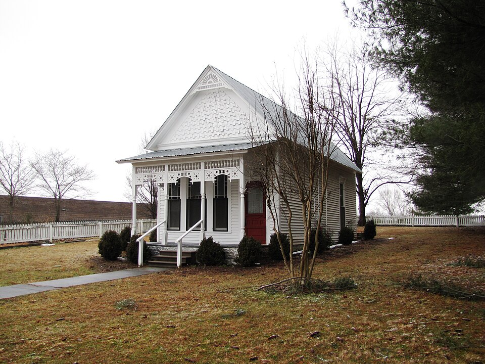
Listed on the National Register of Historic Places in 1975.
One of 6 National Register listings published here for Overton County · listed in 1975 · category: Building.
Sources: the National Register database, National Park Service
Regional context, not property-specific evidence. The federal wildfire occurrence database lists 22 fires within 5 miles of Gov. Albert H. Roberts Law Office between 1998 and 2020, burning about 82 acres in total. None started naturally. 5 were recorded as arson. Distance is straight-line from the map coordinates, so a fire counted here may appear on a neighbouring settlement's page as well.
| Reported cause | Fires |
|---|---|
| Debris and open burning | 12 |
| Arson/incendiarism | 5 |
| Missing data/not specified/undetermined | 5 |
The most recent of them, most recent first, with the day each was reported and the service that recorded it.
| Date | Cause | Size | Reported by | Name on the report |
|---|---|---|---|---|
| 25 September 2005 | Debris and open burning | 4.6 acres | Tennessee Division of Forestry | not named |
| 9 April 2009 | Debris and open burning | 3.0 acres | Tennessee Division of Forestry | CAMP GROUND |
| 21 April 2008 | Missing data/not specified/undetermined | 10 acres | Tennessee Division of Forestry | not named |
| 16 April 2006 | Debris and open burning | 5.7 acres | Tennessee Division of Forestry | not named |
| 14 April 2017 | Arson/incendiarism | 1.3 acres | Tennessee Division of Forestry | BEN SAVAGE LANE FIRE |
| 11 April 2018 | Missing data/not specified/undetermined | 1.0 acres | Tennessee Division of Forestry | CEDAR LN FIRE |
| 30 March 2006 | Debris and open burning | 4.5 acres | Tennessee Division of Forestry | not named |
| 3 March 2007 | Debris and open burning | 3.0 acres | Tennessee Division of Forestry | SANDROCK |
Regional context, not property-specific evidence. The federal mineral resources record lists 9 workings within 5 miles of Gov. Albert H. Roberts Law Office: 5 producers, 3 past producers, 1 prospect. 5 still produce. What was taken out: Stone, Crushed/Broken, Stone, Crushed/Broken, Limestone, General, Strontium, Limestone, General. Distance is straight-line from the map coordinates, so a quarry counted here may appear on a neighbouring settlement's page as well.
| Where | Site | Commodity | Status | Recorded |
|---|---|---|---|---|
| South Quarry | Limestone, General | Past Producer | Sedimentary | |
| Alloms Sand Pit | Strontium | Past Producer | ||
| Gullet Mountain Prospect | Strontium | Prospect | ||
| Livingston Limestone Co. East Quarry | Stone, Crushed/Broken, Limestone, General | Producer | Limestone | |
| Overton County Hwy, Dept. Quarry | Stone, Crushed/Broken, Limestone, General | Producer | 1967 | |
| Livingston Limestone Co East Quarry | Stone, Crushed/Broken | Producer | ||
| Overton County Highway Dept. Quarry | Stone, Crushed/Broken | Producer | ||
| Sand Plant and Mine | Stone, Crushed/Broken | Producer | ||
| South Quarry | Stone, Crushed/Broken | Past Producer |
Regional context, not property-specific evidence. The National Weather Service names Livingston, the town this property stands in, in 75 storm reports between 1995 and 2025: 42 thunderstorm wind, 21 hail, 5 flash flood, 4 lightning. The reports record 5 injuries. Each account below is quoted exactly as the forecast office filed it, from the NOAA Storm Events Database, and each date opens the federal record of that event.
| When | Event | Place named | Harm | What the report says |
|---|---|---|---|---|
| March 1997 | Tornado (F2) | Livingston | 2 hurt, $250,000 | no account filed |
| March 1996 | Tornado (F2) | Livingston | 1 hurt, $5,500,000 | no account filed |
| April 2006 | Thunderstorm Wind | Livingston | 1 hurt, $20,000 | 2 trailers and one home destroyed. Trees down. 80% of the county without power. A big tree landed on a trailer number 7 on Miller St. A man, Paul Stewart, was pinned inside the trailer by the tree. The tree was lifted to free the resident. He was taken to Livingston General Hospital to be checked out. |
| July 1999 | Lightning | Livingston | 1 hurt | A farmer had his hand on a fence. Lightning struck the fence and left him unconscious. A neighbor performed CPR. He was taken to the hospital and recovered. |
| July 2009 | Lightning | Livingston | $500,000 | Overton County 911 Center was damaged by a direct lightning strike which caused a power surge and did major damage to the operations center. |
| July 2009 | Lightning | Livingston | $100,000 | Norris Body Shop was destroyed when it was struck by lightning. |
| May 2020 | Thunderstorm Wind | Livingston | $84,800 | Numerous trees and power lines were blown down across Overton County. Trees were down blocking Greenbriar Road and Hilham Highway at Standing Stone Highway. Power lines were blown down on Carmack Street. |
| June 2009 | Thunderstorm Wind | Livingston | $50,000 | Winds associated with a thunderstorm knocked down the WLIV-AM Radio Station Tower on Rock Grusher Mountain. |
| April 2006 | Lightning | Livingston | $50,000 | Lightning struck an expensive 2-story home on Fairview Lane in Livingston. |
| June 1998 | Hail | Livingston | $50,000 | SKYWARN Spotter reported baseball size hail that damaged the windshield to his car and truck. Newspaper article reported other damages to cars and homes in the area. |
| June 1998 | Thunderstorm Wind | Livingston | $50,000 | EMA Director reported widespread structural damage with numerous roofs blown off buildings. Roads were blocked by trees and downed power lines. About 15 to 20 homes were affected by the storm. |
| February 2009 | Thunderstorm Wind | Livingston | $40,000 | Numerous trees and power lines were downed. In the Allons area, a storage building was picked up and blown into a neighboring field. |
| November 2000 | Thunderstorm Wind | Livingston | $20,000 | EMA and SKYWARN Spotters reported trees down and some roofs blown off. Also some signs were damaged. |
| August 1999 | Flash Flood | Livingston | $20,000 | Sheriff's office reported 2 cars flooded in Livingston. |
| March 1996 | Hail | Livingston | $20,000 | no account filed |
| July 2022 | Thunderstorm Wind | Livingston | $15,000 | Numerous trees and some power poles were blown down across Overton County. |
| June 2019 | Thunderstorm Wind | Livingston | $15,000 | Trees and power lines were blown down across Overton County, including on 4916 Willow Grove Highway, 2179 Standing Stone Highway, 3812 West Paron Road, Rickman Road at Young Road, Lee Dillon Road, Spruce Street, East Fork Lane at Water Tank Road, and Raymond Road. A tree fell on the emergency manager's home at 104 River Trace Drive. |
| May 2017 | Thunderstorm Wind | Livingston | $10,000 | Numerous trees were blown down across Overton County. The worst damage was in the Spring Creek Road area near the Putnam County line, where some homes and vehicles suffered minor damage due to fallen trees. |
| July 2016 | Thunderstorm Wind | Livingston | $10,000 | Overton County EMA director reported numerous trees down across Overton County and personally watched 2 trees get blown down from the 911 center. Power pole fires also reported due to downed power lines. |
| December 2013 | Thunderstorm Wind | Livingston | $10,000 | Trees and power lines were blown down across Overton County. |
| January 2013 | Thunderstorm Wind | Livingston | $10,000 | A few trees and power lines were downed across roadways in the western portion of the county. |
| April 2009 | Thunderstorm Wind | Livingston | $10,000 | Several trees were blown over throughout the county. |
| January 2005 | Thunderstorm Wind | Livingston | $10,000 | Fire department reported wind damage, one barn destroyed, 2 barns with minor damage, part of a canopy removed from gas station, minor roof damage to the garage of a private residence, and a business whose roof was mostly destroyed. One of the barns had a roof taken off on North Oak Street in Livingston. |
| September 2024 | Thunderstorm Wind | Livingston | $5,000 | Severe thunderstorm winds downed trees north-northwest of Livingston. Damages are a rough estimate. |
| April 2022 | Thunderstorm Wind | Livingston | $5,000 | Several trees and power lines were blown down across Overton County. |
| June 2018 | Thunderstorm Wind | Livingston | $5,000 | Trees were blown down at 204 West Henson Street and power lines were blown down on Oak Street and West 4th Street in Livingston. |
| May 2013 | Thunderstorm Wind | Livingston | $5,000 | The public reported a tree falling on a house seven miles west-northwest of Livingston due to winds estimated over 50 mph. |
| April 1996 | Thunderstorm Wind | Livingston | $5,000 | no account filed |
| August 2020 | Thunderstorm Wind | Livingston | $4,000 | Trees were blown down in Livingston on North Spring Street, Medical Drive, First Street, and High Street. |
| June 2019 | Thunderstorm Wind | Livingston | $3,000 | Power lines were blown down along Peach Drive, Hidden Valley Lane, and Fletcher Drive in Livingston. |
| November 2017 | Thunderstorm Wind | Livingston | $3,000 | Numerous reports of power lines down with power outages across Overton County. |
| October 2013 | Thunderstorm Wind | Livingston | $3,000 | A few trees were blown down in Livingston. |
| June 2011 | Thunderstorm Wind | Livingston | $3,000 | A few trees were blown down in Livingston. |
| May 2024 | Thunderstorm Wind | Livingston | $2,000 | Severe thunderstorm winds downed a tree on West Main Street in Livingston. Damages are a rough estimate. |
| May 2024 | Thunderstorm Wind | Livingston | $2,000 | Severe thunderstorm winds downed a tree on Walnut Grove Road in Livingston. Damages are a rough estimate. |
| November 2013 | Thunderstorm Wind | Livingston | $2,000 | A few trees were reported down in the city of Livingston, TN. |
| May 2021 | Thunderstorm Wind | Livingston | $1,000 | Tree was blown down along Windle Community Road. |
| April 2017 | Thunderstorm Wind | Livingston | $1,000 | A tree was blown down at 637 West 4th Street in Livingston. |
| September 2012 | Flash Flood | Livingston | $1,000 | Several roads around Livingston were closed due to flooding. |
| May 2010 | Thunderstorm Wind | Livingston | $1,000 | Several trees were blown down. |
| June 2009 | Thunderstorm Wind | Livingston | $1,000 | A home near the intersection of State Road 84 and Rickman Road just escaped damage when a huge tree limb fell next to it. |
| October 2007 | Thunderstorm Wind | Livingston | $1,000 | The 911 center reported tree limbs were down at the intersection of Celina Highway and Andrew Cove Rd. |
| June 1995 | Thunderstorm Wind | Livingston | $1,000 | One large tree was blown down. |
| May 1995 | Hail | Livingston | $200 | no account filed |
| May 2025 | Hail | Livingston | - | Dime to nickel size hail was reported in Livingston. |
| May 2024 | Hail | Livingston | - | Estimated golf ball size hail was reported from a severe thunderstorm near Livingston. |
| August 2020 | Flash Flood | Livingston | - | Several roads were flooded and closed in Livingston, including Rickman Road at South Wood Road, Oak Street, East Main Street at Windle Street, the 1600 block of Rose Drive, and Henson Street. |
| August 2020 | Flash Flood | Livingston | - | More roads were flooded across Livingston, including the 512 block of West Main Street, Bradford Hicks Drive on-ramp, and Villa Drive at Minnow Pond Road. |
| June 2018 | Flood | Livingston | - | Street flooding was reported on the Livingston Bypass. |
| February 2012 | Hail | Livingston | - | Quarter size hail was reported near Highway 84 at Industrial Park Drive. |
| April 2005 | Hail | Livingston | - | Penny size hail reported. |
| May 2005 | Thunderstorm Wind | Livingston | - | Power lines and tree limbs were down. |
| July 2005 | Hail | Livingston | - | Quarter size hail observed. |
| August 2005 | Thunderstorm Wind | Livingston | - | Tree down on Highway 42. |
| May 2003 | Thunderstorm Wind | Livingston | - | Law enforcement reported trees were blown down. |
| July 2003 | Thunderstorm Wind | Livingston | - | Newspaper story about trees and power lines being blown down around the Livingston area. Some roadways were blocked by fallen trees. A tree fell on a front yard near the intersection of Jamestown Highway and Alvin Garrett Lane which is east of Livingston. Another tree was uprooted in Livingston near the intersection of Doak Street and North Goodpasture Street. There were at least 4 other reports of trees being blown down or uprooted in Livingston. |
| August 2002 | Hail | Livingston | - | Nickel size hail reported. |
| June 2001 | Thunderstorm Wind | Livingston | - | Trees and tree limbs were blown down. |
| January 2000 | Thunderstorm Wind | Livingston | - | A large tree fell on a home located on Seventh Avenue in Livingston. There were other reports of downed trees across the county. |
| May 2000 | Thunderstorm Wind | Livingston | - | Newspaper article related trees and power lines were down in Livingston area. |
No historic map-sheet match is published for this property yet. That does not mean no map exists. This record needs a coordinate-quality review before it can be joined to a sheet boundary. Browse the county's mapped places while that work is pending.
Other National Register properties close enough to walk or drive between, ordered by distance from this one. Both positions come from the same geocoding pass that matched these properties to their map sheets.
| Photograph | Property | Distance | Listed |
|---|---|---|---|
 | Overton County Courthouse | under 500 feet | 1980 |
 | American Legion Bohannon Post #4 | under 500 feet | 2012 |
 | Alpine Institute | 5.8 miles | 2002 |
 | Standing Stone Rustic Park Historic District | 7.6 miles | 1986 |
| National Archives record | The nomination case file for reference 75001773 in Record Group 79. |
| Overton County | All 6 listed properties in this county. |