BlockBefore
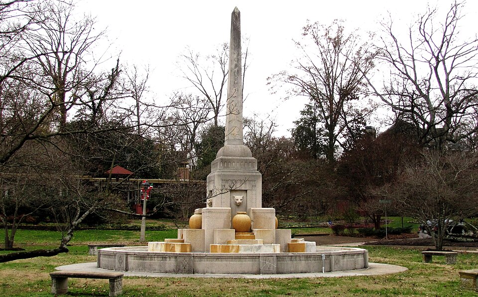
Photograph of Sequoyah Hills
Photograph by Brian Stansberry, CC BY 3.0. Via Wikimedia Commons.

Talahi Improvements

Listed on the National Register of Historic Places in 1979.

From the record

“Sequoyah Hills is a neighborhood in Knoxville, Tennessee, United States, named for the Cherokee scholar Sequoyah. It is located off Kingston Pike, between the city's downtown and West Knoxville.”

Wikipedia article Sequoyah Hills, CC BY-SA 4.0.

One of 120 National Register listings published here for Knox County · listed in 1979 · category: Site.

Sources: the Wikipedia article · the National Register database, National Park Service

The listing

  • Address. Off U.S. 129, Knoxville, 37919
  • When was it listed? December 1979
  • Category. site
  • District. District 4
  • National Register reference number. 79002447 - assigned by the National Park Service when the property was listed.

Fires near this property

14 since 2001

Regional context, not property-specific evidence. The federal wildfire occurrence database lists 14 fires within 5 miles of Talahi Improvements between 2001 and 2020, burning about 194 acres in total. 1 started naturally. 2 were recorded as arson. Distance is straight-line from the map coordinates, so a fire counted here may appear on a neighbouring settlement's page as well.

Reported cause Fires
Arson/incendiarism2
Debris and open burning2
Missing data/not specified/undetermined2
Recreation and ceremony2
Natural1
Equipment and vehicle use1
Other causes1
Power generation/transmission/distribution1
Smoking1
Railroad operations and maintenance1

The most recent of them, most recent first, with the day each was reported and the service that recorded it.

DateCause SizeReported by Name on the report
2 August 2015Smokingunder an acreTennessee Division of ForestryARBOR PLACE
4 June 2011Arson/incendiarism4.0 acresTennessee Division of ForestrySMITH EVANS LN
9 April 2009Power generation/transmission/distribution30 acresTennessee Division of ForestryCHEROKEE TRAIL
5 April 2020Debris and open burning2.0 acresTennessee Division of ForestryBROWN
23 April 2007Railroad operations and maintenance100 acresTennessee Division of ForestrySHARPS RIDGE TOWER
14 April 2014Recreation and ceremony5.0 acresTennessee Division of ForestryLIPPENCOTT
7 March 2014Debris and open burning10 acresTennessee Division of ForestryWHITE FERRY
31 March 2015Recreation and ceremony1.0 acresTennessee Division of ForestrySHARP RIDGE

Every fire recorded in Knox County

Mines and quarries near this property

10 of 56 shown

Regional context, not property-specific evidence. The federal mineral resources record lists 56 workings within 5 miles of Talahi Improvements: 49 past producers, 3 producers, 2 occurrences, 1 prospect. 3 still produce. What was taken out: Marble, Dimension, Stone, Crushed/Broken, Limestone, Dimension, Limestone, General. Distance is straight-line from the map coordinates, so a quarry counted here may appear on a neighbouring settlement's page as well.

Where SiteCommodity StatusRecorded
City Quarry KnoxvilleStone, Crushed/Broken, Limestone, GeneralProducer1850
Knoxville Sand & Gravel PlantSand and Gravel, ConstructionProducerUnconsolidated Sediments
Lead ProspectLeadOccurrence
Giezentanner ProspectManganeseProspect
Green ProspectsManganeseOccurrence
Knoxville QuarryClayUnknown
Shale PitClayPast Producer
Dixie Lee QuarryLimestone, GeneralPast ProducerSedimentary
Freeway QuarryLimestone, GeneralPast ProducerSedimentary
Kincaid QuarryLimestone, GeneralPast ProducerSedimentary

Every working recorded in Knox County

Storms near this property

60 of 293 shown

Regional context, not property-specific evidence. The National Weather Service names Knoxville, the town this property stands in, in 293 storm reports between 1993 and 2026: 196 thunderstorm wind, 62 hail, 16 flash flood, 14 flood. The reports record 2 deaths. Each account below is quoted exactly as the forecast office filed it, from the NOAA Storm Events Database, and each date opens the federal record of that event.

WhenEvent Place namedHarm What the report says
November 2000Thunderstorm WindKnoxville2 killed, $3,000no account filed
May 2003Flash FloodKnoxville$2,800,000Kingston Pike and Gleason Road flooded and closed.
February 2011FloodKnoxville$1,960,000Broadcast media reported that heavy rain from a thunderstorm caused flooding countywide.
May 1996Thunderstorm WindKnoxville$500,000no account filed
May 2003Tornado (F1)Knoxville$200,000no account filed
May 2003Tornado (F1)Knoxville$150,000no account filed
July 2004Thunderstorm WindKnoxville$70,000no account filed
June 2011Tornado (EF0)West Knoxville$40,000A NWS storm surveyed reported an EF-0 tornado touched along Western Avenue in Knoxville. It had a path length of around 1 mile and a path width of 100 yards. The max wind of 80 mph downed several trees and powerlines along with causing slight roof damage on 2 homes.
May 2006Thunderstorm WindKnoxville$35,000no account filed
July 2002Thunderstorm WindKnoxville$35,000no account filed
April 2011Thunderstorm WindKnoxville$30,000Amateur radio personnel reported several buildings damaged or destroyed by thunderstorm wind at the University of Tennessee hospital property in Knoxville.
June 2011Thunderstorm WindKnoxville$30,000Amateur radio personnel reported numerous trees downed by thunderstorm wind in Knoxville. Wind also downed a tree on a house.
April 2011HailKnoxville$30,000The public reported thunderstorms produced baseball-size hail 2 miles southeast of Knoxville damaging vehicles in the area.
July 2004Thunderstorm WindKnoxville$30,000no account filed
April 2011Thunderstorm WindKnoxville$25,000Amateur radio personnel reported numerous trees downed by thunderstorm wind at the Martha Washington Heights subdivision in Knoxville.
August 2006LightningKnoxville$25,000Lightning struck and damaged an apartment building on Middle Brook Pike in Knoxville. One unit was destroyed as the roof caught fire.
July 2006Thunderstorm WindKnoxville$25,000no account filed
May 2004Thunderstorm WindKnoxville$25,000no account filed
July 2022FloodKnoxville$20,000Vehicles submerged along 23rd Street. A few residents were rescued from nearby apartments.
June 2011Flash FloodKnoxville$20,000Law enforcement personnel reported heavy rain from thunderstorm caused flooding on many roads across the county.
April 2011Thunderstorm WindKnoxville$20,000Law enforcement personnel reported numerous trees and powerlines downed by thunderstorm wind countywide.
June 2009Thunderstorm WindKnoxville$20,000Law enforcement officials reported numerous trees downed by thunderstorm winds countywide.
June 2008Thunderstorm WindSouth Knoxville$20,000Dispatch reported several trees downed by thunderstorm winds in the Knoxville area. A tree fell on home in Knoxville damaging the roof.
June 2007Thunderstorm WindKnoxville$20,000Thunderstorm winds downed several trees and powerlines in Knoxville and the surrounding areas.
August 2006Thunderstorm WindKnoxville$20,000Numerous trees and powerlines down across the southeast half of the county. Over 17,000 homes lost power.
June 2005Thunderstorm WindKnoxville$20,000Numerous trees down in city and county-wide.
August 2005Thunderstorm WindKnoxville$20,000Several trees down in and around the Halls Crossroads area. Reported by Knox County Highway Dept.
August 2005Thunderstorm WindKnoxville$20,000A few trees down on powerlines in north Knox County. Reported by Clinton Utilities.
August 2005Thunderstorm WindKnoxville$20,000Numerous trees and powerlines down.
October 2005Thunderstorm WindKnoxville$20,000Numerous trees and powerlines downed across north Knox County.
June 2004Thunderstorm WindKnoxville$20,000Several trees down across east half of county
June 2004Thunderstorm WindKnoxville$20,000Tree down on automobile on Asheville Hwy
May 2005Thunderstorm WindKnoxville$20,000no account filed
July 2004Thunderstorm WindKnoxville$20,000no account filed
February 1998Thunderstorm WindKnoxville$20,000no account filed
October 2001Thunderstorm WindKnoxville$19,000Trees and power lines down.
June 2009Thunderstorm WindWest Knoxville$18,000The local television station reported numerous trees downed by thunderstorm winds across the county. A few homes and a church in Knoxville were also damaged by the winds.
April 2006Thunderstorm WindKnoxville$18,000Numerous trees down in Knoxville.
June 2006Thunderstorm WindKnoxville$18,000Several trees and powerlines down in Knoxville.
June 2005Thunderstorm WindKnoxville$18,000One tree down in Knoxville and a few other trees across the rest of the county.
June 2005Thunderstorm WindKnoxville$18,000Several trees and a powerline down in and around the city of Knoxville.
December 2005Thunderstorm WindKnoxville$18,000Several trees down countywide
March 2004Thunderstorm WindKnoxville$18,000no account filed
February 2026Thunderstorm WindSouth Knoxville$15,000Strips of green tin roof were peeled off an inn on Chapman Highway by severe thunderstorm wind gusts.
April 2015Thunderstorm WindKnoxville$15,000Dispatch personnel reported multiple trees and few powerlines downed by thunderstorm wind across the county.
April 2014Thunderstorm WindKnoxville$15,000Law enforcement personnel reported numerous trees downed by thunderstorm wind countywide.
February 2011Thunderstorm WindKnoxville$15,000Law enforcement personnel reported five trees and two powerlines downed by thunderstorm wind in and around Knoxville.
February 2011Thunderstorm WindKnoxville$15,000A trained spotter reported several trees and a small carport downed by thunderstorm wind six miles north of Knoxville on Conner Drive.
June 2011Thunderstorm WindKnoxville$15,000Amateur radio personnel reported several trees and limbs downed by thunderstorm wind in Knoxville.
June 2009Thunderstorm WindKnoxville$15,000Law enforcement personnel reported several trees and powerlines downed by thunderstorm winds in Knoxville.
June 2009Thunderstorm WindKnoxville$15,000The newspaper reported several trees and powerlines downed by thunderstorm winds in Knoxville. In addition, the roof of a home in Knoxville was damaged by the wind.
June 2007Thunderstorm WindKnoxville$15,000Thunderstorm winds downed four trees in west Knoxville.
June 2004Thunderstorm WindKnoxville$15,000Numerous trees down throughout the city
September 1995Thunderstorm WindKnoxville$15,000A thunderstorm knocked down trees and electrical wires around the Knoxville area.
July 2005Thunderstorm WindKnoxville$15,000no account filed
July 2004Thunderstorm WindKnoxville$15,000no account filed
November 2002Thunderstorm WindNorth Knoxville$15,000no account filed
July 1999Thunderstorm WindKnoxville$15,000no account filed
June 2014Thunderstorm WindKnoxville$12,000Law enforcement personnel reported many trees downed by thunderstorms wind countywide.

Every storm recorded in Knox County

Map coverage status

No historic map-sheet match is published for this property yet. That does not mean no map exists. This record needs a coordinate-quality review before it can be joined to a sheet boundary. Browse the county's mapped places while that work is pending.

Listed places nearby

6 within 8 miles

Other National Register properties close enough to walk or drive between, ordered by distance from this one. Both positions come from the same geocoding pass that matched these properties to their map sheets.

Photograph PropertyDistance Listed
Benjamin Morton House0.9 miles2004
Bleak House1.0 miles1984
Kingston Pike Historic District1.0 miles1996
H. L. Dulin House1.0 miles1974
Westwood1.1 miles1984
Daniel House1.1 miles1998

Sources for this property

National Archives recordThe nomination case file for reference 79002447 in Record Group 79.
Wikipedia articleCommunity-written account of this property, licensed CC BY-SA.
Knox CountyAll 120 listed properties in this county.

Provenance

  • Listing record. National Park Service National Register of Historic Places, listed-properties dataset, current to 2026-05-22.
  • Map join. Address geocoded through the United States Census geocoder, then tested against the published boundary of every sheet in the USGS Historical Topographic Map Collection.
  • How this page is made. Listing fields come from federal records; map-sheet coverage is a labelled coordinate-to-boundary calculation, not a source-field claim.
  • Wildfire. Short, Karen C. 2022. Spatial wildfire occurrence data for the United States, 1992-2020 [FPA_FOD_20221014]. 6th Edition. Fort Collins, CO: Forest Service Research Data Archive. https://doi.org/10.2737/RDS-2013-0009.6 Collected with United States Government funding and usable without additional permissions or fees.
  • Mines and quarries. USGS Mineral Resources Data System (MRDS) https://mrdata.usgs.gov/mrds/ A work of the United States government, no copyright under 17 U.S.C. 105.
  • Storms. NOAA National Centers for Environmental Information, Storm Events Database https://www.ncei.noaa.gov/stormevents/ A work of the United States government, no copyright under 17 U.S.C. 105. Narratives are quoted verbatim from the National Weather Service report and are not edited or summarised.