 Block
From the record
One of 50 National Register listings published here for Rutherford County · listed in 1979 · category: Building.
Sources: the National Register database, National Park Service · the Wikipedia article
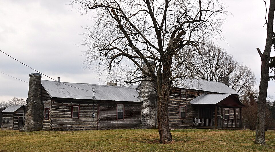
Listed on the National Register of Historic Places in 1979.
One of 50 National Register listings published here for Rutherford County · listed in 1979 · category: Building.
Sources: the National Register database, National Park Service · the Wikipedia article
Regional context, not property-specific evidence. The federal wildfire occurrence database lists 1 fire within 5 miles of Morgan House in 2012, burning about 25 acres in total. None started naturally. None was recorded as arson. Distance is straight-line from the map coordinates, so a fire counted here may appear on a neighbouring settlement's page as well.
| Reported cause | Fires |
|---|---|
| Debris and open burning | 1 |
The most recent of them, most recent first, with the day each was reported and the service that recorded it.
| Date | Cause | Size | Reported by | Name on the report |
|---|---|---|---|---|
| 25 June 2012 | Debris and open burning | 25 acres | Tennessee Division of Forestry | FAULK |
Regional context, not property-specific evidence. The federal mineral resources record lists 1 working within 5 miles of Morgan House: 1 past producer. None of them still produces. What was taken out: Iron. Distance is straight-line from the map coordinates, so a quarry counted here may appear on a neighbouring settlement's page as well.
| Where | Site | Commodity | Status | Recorded |
|---|---|---|---|---|
| Jenkins Branch Mine | Iron | Past Producer |
Regional context, not property-specific evidence. The National Weather Service names Christiana, the town this property stands in, in 25 storm reports between 1997 and 2024: 12 thunderstorm wind, 10 hail, 1 flood, 1 tornado. No death or injury is recorded in these reports. Each account below is quoted exactly as the forecast office filed it, from the NOAA Storm Events Database, and each date opens the federal record of that event.
| When | Event | Place named | Harm | What the report says |
|---|---|---|---|---|
| September 2009 | Flood | Christiana | $250,000 | Water was over the roads and flooding of at least 50 homes in Christiana area was reported. Type of water damage to homes was unknown. Newspaper also reported that eighteen families had to be evacuated in the county because of the persistent rain that had cows wading in the water almost up to their neck. Boats and trackers were used to rescue people stranded in their homes. No one was reported hurt. Newspaper also reported that Christiana Elementary School's gym was being used as a shelter for those being evacuated. CoCoRaHS reports from this area showed up to 6 inches of rainfall having occurred. In the Christiana community, waters reportedly rose to more than 8 feet deep at one point. Cars, sheds, and homes across certain parts of the Christiana area were submerged. The Stones River swelled to a larger size than one local resident said she has seen in her entire 50 years of living in Rutherford County. 23 roads were closed across the county. A few miles away|from Long Creek on Christiana-Hover's Gap Road, a local farmer had 60 hay bales|moved to this location. These hay bales were picked up by moving flood waters|and crashed through a high tensile fence held up by steel pools. These bales had|to be moved back to Hover's Gap Road by six individuals. Each of these bales weighed 1,200 pounds apiece when they are dry, retail for $80 each, with a lot of them getting water logged. Several pieces of farm equipment were also damaged by rising waters, which will require at least mechanical work. A nearby farm reportedly lost 400 chickens to the flood. This report could not be confirmed. A car was swept away by rising waters on Elam Road near Christiana. The driver was not injured. The fast moving flood waters receded across the area by late Thursday afternoon. |
| November 2018 | Lightning | Christiana | $200,000 | Lightning struck a house on Barley Drive causing a large fire in the attic and severe damage to the home. |
| March 2011 | Tornado (EF0) | Christiana | $25,000 | Damaged occurred on Walnut Grove Road near U.S. Highway 231. Some trees were uprooted and a small portion of shingles were removed from a few homes. A couple of outbuildings were also damaged. Maximum wind speeds associated with this tornado were estimated to be around 80 mph. |
| May 1997 | Thunderstorm Wind | Christiana | $20,000 | Windows were blown out of homes and a barn was destroyed by strong thunderstorm winds. |
| March 2011 | Thunderstorm Wind | Christiana | $10,000 | Trees were downed in Christiana. |
| June 2016 | Thunderstorm Wind | Christiana | $5,000 | Chicken coop blown apart and two trees also down in Christiana. |
| July 2022 | Thunderstorm Wind | Christiana | $3,000 | Facebook reports and photos showed trees and power lines blown down in Christiana. |
| February 2021 | Thunderstorm Wind | Christiana | $3,000 | A Twitter tSpotter report indicated a couple of trees and large limbs were blown down near Christiana. |
| April 2014 | Thunderstorm Wind | Christiana | $1,000 | A large tree limb was snapped in Christiana. |
| June 1997 | Thunderstorm Wind | Christiana | $1,000 | Several trees were blown down on power lines. |
| May 2024 | Hail | Christiana | - | Estimated 1.5 to 2 inch hail was reported from a severe thunderstorm near Bell Buckle in Rutherford County. |
| July 2013 | Hail | Christiana | - | Quarter sized hail was reported via Twitter at the intersection of Highway 231 and Parsons Road in Christiana. |
| June 2013 | Hail | Christiana | - | Pea to nickel size hail was reported in Christiana. |
| May 2009 | Hail | Christiana | - | Nickel size hail was reported along Highway 231 South. |
| August 2005 | Thunderstorm Wind | Christiana | - | 4 to 5 roads were blocked with downed trees. |
| March 2004 | Thunderstorm Wind | Christiana | - | Tin roof torn off a barn at Christiana. |
| May 2004 | Thunderstorm Wind | Christiana | - | Winds were estimated to be around 60 mph with trees down. |
| July 2004 | Thunderstorm Wind | Christiana | - | Sheriff's office reported trees down. |
| April 2003 | Hail | Christiana | - | Hail the size of quarters was reported by SKYWARN Spotter near U.S. Highway 231. |
| January 1999 | Hail | Christiana | - | Spotter reported dime size hail. |
| April 1998 | Thunderstorm Wind | Christiana | - | NWS employee reported exit sign blown down over at mile marker 90 and 91, I-24 westbound. |
| July 1997 | Hail | Christiana | - | Hail the size of quarters was reported by local law enforcement. |
| March 2012 | Hail | Christiana | - | no account filed |
| August 2012 | Hail | Christiana | - | no account filed |
| April 2006 | Hail | Christiana | - | no account filed |
No historic map-sheet match is published for this property yet. That does not mean no map exists. This record needs a coordinate-quality review before it can be joined to a sheet boundary. Browse the county's mapped places while that work is pending.
Other National Register properties close enough to walk or drive between, ordered by distance from this one. Both positions come from the same geocoding pass that matched these properties to their map sheets.
| Photograph | Property | Distance | Listed |
|---|---|---|---|
| Robert Andrew Smith Farm | 7.8 miles | 1993 |
| National Archives record | The nomination case file for reference 79002457 in Record Group 79. |
| Wikipedia article | Community-written account of this property, licensed CC BY-SA. |
| Rutherford County | All 50 listed properties in this county. |