BlockBefore

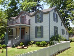
Goodwinslow

Listed on the National Register of Historic Places in 1979.

From the record

“Goodwinslow, also known as Chapman House, is a historic house in Raleigh, Tennessee. It was built from 1875 to 1900 for William Washington Goodwin.”

Wikipedia article Goodwinslow, CC BY-SA 4.0.

One of 216 National Register listings published here for Shelby County · listed in 1979 · category: Building.

Sources: the Wikipedia article · the National Register database, National Park Service

The listing

  • What is counted as historic. The nomination lists 1 building as contributing to the listing.
  • Address. 4066 James Rd, Raleigh, 38128
  • When was it listed? December 1979
  • Category. building
  • District. District 6
  • National Register reference number. 79002482 - assigned by the National Park Service when the property was listed.

Mines and quarries near this property

10 of 11 shown

Regional context, not property-specific evidence. The federal mineral resources record lists 11 workings within 5 miles of Goodwinslow: 6 producers, 4 past producers, 1 plant. 7 still produce. What was taken out: Sand and Gravel, Construction, Clay, Chromium, Silica, Manganese, Iron. Distance is straight-line from the map coordinates, so a quarry counted here may appear on a neighbouring settlement's page as well.

Where SiteCommodity StatusRecorded
(Facility) Woodstock SmelterChromium, Silica, Manganese, IronPlant
Denies PitClayPast Producer
Standard Brick Co. PitClayPast Producer
#2 Fryplant Dredge OperationSand and Gravel, ConstructionProducerUnconsolidated Sediments
#2 Hollywood PlantSand and Gravel, ConstructionProducer1967
Allen Materials, Inc. PitSand and Gravel, ConstructionPast Producer
Allen Materials, Inc. Plant Dredge OperationSand and Gravel, ConstructionProducerUnconsolidated Sediments
Allen MineSand and Gravel, ConstructionProducer
Connie DredgeSand and Gravel, ConstructionPast Producer
Number 2 Fry PlantSand and Gravel, ConstructionProducer

Every working recorded in Shelby County

Storms near this property

12 since 1998

Regional context, not property-specific evidence. The National Weather Service names Raleigh, the town this property stands in, in 12 storm reports between 1998 and 2020: 6 thunderstorm wind, 3 hail, 3 flash flood. No death or injury is recorded in these reports. Each account below is quoted exactly as the forecast office filed it, from the NOAA Storm Events Database, and each date opens the federal record of that event.

WhenEvent Place namedHarm What the report says
March 2017Thunderstorm WindRaleigh$150,000Damage occurred near the old Raleigh Springs Mall with several large tress either uprooted or snapped. Tree and shingle damage occurred to several homes. The worst damage was about 100 yards long by 150 yards wide. Winds were estimated at 90 mph.
March 2017Thunderstorm WindRaleigh$30,000A large tree fell on a house and a car in Raleigh. One man was rescued from the home.
May 2019Thunderstorm WindRaleigh$5,000Five poles down on Stage Road near Butterfield.
March 2001HailRaleigh$750no account filed
May 2002HailRaleigh$10no account filed
April 1998HailRaleigh$10no account filed
June 2020Thunderstorm WindRaleigh-Trees and powerlines knocked down across the Memphis area.
February 2019Flash FloodRaleigh-Significant flooding over the road at the intersection of Frayser Boulevard and Warford Street.
June 2013Thunderstorm WindRaleigh-Straight line winds knocked a tree on to a truck in the Raleigh area.
April 2010Thunderstorm WindRaleigh-Straight line winds knocked trees and power lines down in the Berclair and Raleigh areas. A tree was knocked down onto a vehicle at the intersection of North Graham Street and Macon Road. In addition, a large tree fell onto a house on Victor Drive. A tree knocked down power lines on Jewell Road.
July 2009Flash FloodRaleigh-Heavy rain produced flash flooding at the intersection of James Road and New Raleigh Road in Raleigh.
January 2008Flash FloodRaleigh-Heavy rain produced flash flooding at the intersection of Austin Peay Highway and Coleman Road in Raleigh.

Every storm recorded in Shelby County

Map coverage status

No historic map-sheet match is published for this property yet. That does not mean no map exists. This record needs a coordinate-quality review before it can be joined to a sheet boundary. Browse the county's mapped places while that work is pending.

Listed places nearby

6 within 8 miles

Other National Register properties close enough to walk or drive between, ordered by distance from this one. Both positions come from the same geocoding pass that matched these properties to their map sheets.

Sources for this property

National Archives recordThe nomination case file for reference 79002482 in Record Group 79.
Wikipedia articleCommunity-written account of this property, licensed CC BY-SA.
Shelby CountyAll 216 listed properties in this county.

Provenance

  • Listing record. National Park Service National Register of Historic Places, listed-properties dataset, current to 2026-05-22.
  • Map join. Address geocoded through the United States Census geocoder, then tested against the published boundary of every sheet in the USGS Historical Topographic Map Collection.
  • How this page is made. Listing fields come from federal records; map-sheet coverage is a labelled coordinate-to-boundary calculation, not a source-field claim.
  • Mines and quarries. USGS Mineral Resources Data System (MRDS) https://mrdata.usgs.gov/mrds/ A work of the United States government, no copyright under 17 U.S.C. 105.
  • Storms. NOAA National Centers for Environmental Information, Storm Events Database https://www.ncei.noaa.gov/stormevents/ A work of the United States government, no copyright under 17 U.S.C. 105. Narratives are quoted verbatim from the National Weather Service report and are not edited or summarised.