 Block
From the record
One of 10 National Register listings published here for Dyer County · listed in 1983 · category: Building.
Sources: the National Register database, National Park Service · the Wikipedia article
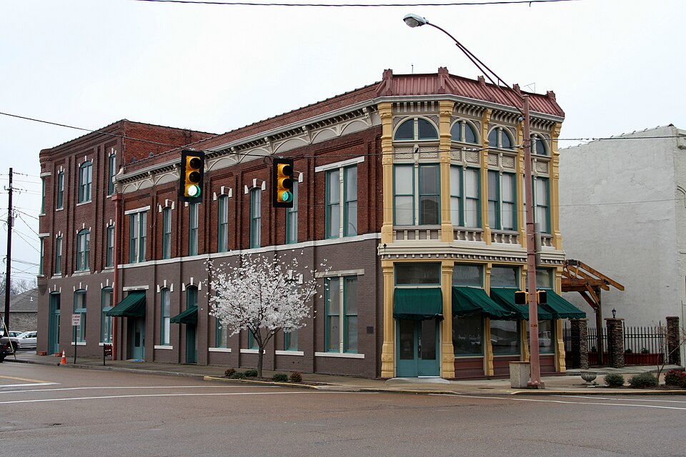
Listed on the National Register of Historic Places in 1983.
One of 10 National Register listings published here for Dyer County · listed in 1983 · category: Building.
Sources: the National Register database, National Park Service · the Wikipedia article
Regional context, not property-specific evidence. The federal wildfire occurrence database lists 88 fires within 5 miles of Bank of Dyersburg between 1997 and 2020, burning about 341 acres in total. None started naturally. 9 were recorded as arson. Distance is straight-line from the map coordinates, so a fire counted here may appear on a neighbouring settlement's page as well.
| Reported cause | Fires |
|---|---|
| Debris and open burning | 54 |
| Equipment and vehicle use | 11 |
| Arson/incendiarism | 9 |
| Missing data/not specified/undetermined | 6 |
| Misuse of fire by a minor | 4 |
| Power generation/transmission/distribution | 3 |
| Railroad operations and maintenance | 1 |
The most recent of them, most recent first, with the day each was reported and the service that recorded it.
| Date | Cause | Size | Reported by | Name on the report |
|---|---|---|---|---|
| 7 September 2011 | Equipment and vehicle use | 25 acres | Tennessee Division of Forestry | POST 104 |
| 24 September 2002 | Equipment and vehicle use | 6.0 acres | Tennessee Division of Forestry | not named |
| 21 September 1999 | Debris and open burning | under an acre | Tennessee Division of Forestry | not named |
| 18 September 2000 | Equipment and vehicle use | 20 acres | Tennessee Division of Forestry | not named |
| 17 September 2008 | Debris and open burning | 5.0 acres | Tennessee Division of Forestry | not named |
| 16 September 2008 | Missing data/not specified/undetermined | 23 acres | Tennessee Division of Forestry | not named |
| 15 September 2000 | Debris and open burning | 2.0 acres | Tennessee Division of Forestry | not named |
| 13 September 2010 | Equipment and vehicle use | 1.0 acres | Tennessee Division of Forestry | KITE FIRE |
Regional context, not property-specific evidence. The federal mineral resources record lists 1 working within 5 miles of Bank of Dyersburg: 1 past producer. None of them still produces. What was taken out: Clay. Distance is straight-line from the map coordinates, so a quarry counted here may appear on a neighbouring settlement's page as well.
| Where | Site | Commodity | Status | Recorded |
|---|---|---|---|---|
| Dyersburg Pit | Clay | Past Producer |
Regional context, not property-specific evidence. The National Weather Service names Dyersburg, the town this property stands in, in 70 storm reports between 1993 and 2026: 27 thunderstorm wind, 26 hail, 5 lightning, 5 flash flood. The reports record 10 injuries. Each account below is quoted exactly as the forecast office filed it, from the NOAA Storm Events Database, and each date opens the federal record of that event.
| When | Event | Place named | Harm | What the report says |
|---|---|---|---|---|
| May 2003 | Tornado (F2) | Dyersburg | 10 hurt, $50,000,000 | The tornado touched down just southwest of Dyersburg and tracked northeast through the middle of the city. Over 70 homes were destroyed and more than 300 were damaged. Eight commercial buildings were destroyed and nearly 20 were damaged. |
| May 2010 | Flood | Dyersburg | $9,500,000 | Heavy rain of 10 to 20 inches produced record breaking flooding along the North Fork Forked Deer River in Dyer County. South Dyersburg was hit extremely hard with numerous homes and businesses sustaining major damage. At one point portions of South Dyersburg was underneath as much as 4 feet of water. In total, at least 600 structures received damage from the flooding. |
| April 2006 | Hail | Dyersburg | $250,000 | Over 250 vehicles were damaged by large hail at three car dealerships in Dyersburg. The hail also caused damage to the metal siding of one of the dealerships. |
| December 2007 | Lightning | Dyersburg | $100,000 | Lightning struck the Pierce Lane Church of Christ Church in Dyersburg. The lighnting strike produced a fire that resulted in the church being destroyed. |
| April 1996 | Thunderstorm Wind | Dyersburg | $100,000 | no account filed |
| March 2017 | Tornado (EF0) | Dyersburg | $50,000 | A weak tornado embedded within a line of severe thunderstorms touched down south of the Dyersburg Primary School and tracked east-northeast. The tornado struck a farm on Jones Road tearing the roof off one barn and causing significant damage to another. A house suffered shingle damage and some outbuildings were also damaged. Intermittent tree damage occurred along the path. The tornado lifted at Welch Road. Peak winds were estimated at 80 mph. |
| March 2000 | Lightning | Dyersburg | $30,000 | Lightning damaged the 911 antenna on the Dyersburg Emergency Operations Center. |
| April 2026 | Tornado (EF0) | Dyersburg | $25,000 | A weak, short-lived EF0 tornado touched down on the southeast side of Dyersburg shortly after midnight Tuesday, April 28. The most significant damage occurred at a warehouse on E Court St, where ten skylights were blown out, and a large metal panel was pulled from the side of the building. The tornado continued southeastward almost parallel to E Court Street, causing tree damage on both sides of the road. Minor roof damage was noted at a house on Auburn Ave. The tornado lifted just before reaching U.S. Highway 412. |
| May 2022 | Thunderstorm Wind | Dyersburg | $25,000 | Numerous trees down along East Court Street. A tree fell on house damaging the roof. A tree fell on a car as well. |
| June 2019 | Thunderstorm Wind | Dyersburg | $20,000 | Tractor trailer blown over on Highway 412 in Dyersburg. |
| December 2016 | Thunderstorm Wind | Dyersburg | $20,000 | Large trees uprooted with lots of tree limbs down. One carport roof torn off with home shingle damage and broken windows. |
| April 2016 | Thunderstorm Wind | Dyersburg | $10,000 | Straight line winds damaged the roof and siding of a home. A privacy fence was downed along with a few trees. |
| August 2006 | Thunderstorm Wind | Dyersburg | $10,000 | Straight line winds knocked down dozens of trees and several power poles. The downed power lines left 300 homes without power. The hardest hit area occurred in the Miltown and St. John Avenue area of Dyersburg. A tractor-trailor was also blown off U.S. Highway 412 north of the SR 104 exit by the straightline winds. |
| July 2004 | Thunderstorm Wind | Dyersburg | $10,000 | A few trees were blown down on top of a building. |
| June 2004 | Lightning | Dyersburg | $10,000 | Two homes in Dyer county suffered damage after lightning strikes. One of the houses caught on fire. |
| May 2003 | Tornado (F0) | Dyersburg | $10,000 | The tornado touched down just east of Dyersburg and moved northeast. Many trees were blown down. |
| June 1999 | Thunderstorm Wind | Dyersburg | $10,000 | Several trees and power lines were knocked down. |
| February 1999 | Thunderstorm Wind | Dyersburg | $10,000 | Some aluminium scaffolding was blown down. A fence was also blown down. A number of trees were knocked down as well. |
| May 1999 | Flash Flood | Dyersburg | $10,000 | Three homes were evacuated becuase of flooding. |
| May 2022 | Thunderstorm Wind | Dyersburg | $9,000 | A couple of large trees down on the east side of Dyersburg. |
| July 2004 | Thunderstorm Wind | Dyersburg | $5,000 | Some power lines were blown down. |
| August 2003 | Thunderstorm Wind | Dyersburg | $5,000 | A few trees were blown down. |
| May 2002 | Lightning | Dyersburg | $5,000 | A lightning strike knocked out the tornado sirens for the city of Dyersburg. |
| October 2001 | Thunderstorm Wind | Dyersburg | $5,000 | A few trees were blown down. |
| August 1998 | Flash Flood | Dyersburg | $5,000 | Several streets were flooded forcing about 30 residents to be evacuated. |
| June 1998 | Thunderstorm Wind | Dyersburg | $5,000 | Several trees and power lines were knocked down. The roof of a restaurant near the Dyersburg Airport was blown off. A DC-3 airplane was blown into a hangar. |
| November 1998 | Thunderstorm Wind | Dyersburg | $5,000 | Some trees were knocked down. One tree fell on a car. |
| May 1995 | Thunderstorm Wind | Dyersburg | $5,000 | Numerous trees were blown down. |
| April 2011 | Thunderstorm Wind | Dyersburg | $4,000 | Straight line winds tore a wooden porch from a house as well as some shingles. |
| April 2025 | Thunderstorm Wind | Dyersburg | $3,000 | Multiple trees uprooted along Troy Circle in Dyersburg. |
| November 2007 | Hail | Dyersburg | $3,000 | no account filed |
| July 1997 | Thunderstorm Wind | Dyersburg | $2,000 | Some minor structural damage occurred. Some trees were also knocked down. |
| July 1996 | Thunderstorm Wind | Dyersburg | $2,000 | no account filed |
| June 1996 | Lightning | Dyersburg | $2,000 | no account filed |
| May 2003 | Hail | Dyersburg | $1,850 | no account filed |
| May 2003 | Flash Flood | Dyersburg | $1,000 | Some roads were flooded. |
| July 2001 | Thunderstorm Wind | Dyersburg | $1,000 | Some large trees limbs were blown down. |
| July 1998 | Flash Flood | Dyersburg | $1,000 | Some roads were closed due to flash flooding. |
| July 1998 | Flood | Dyersburg | $1,000 | A few roads were covered with water. |
| April 2006 | Hail | Dyersburg | $1,000 | no account filed |
| May 1993 | Thunderstorm Wind | Dyersburg | $500 | no account filed |
| March 2005 | Hail | Dyersburg | $100 | no account filed |
| February 2005 | Hail | Dyersburg | $100 | no account filed |
| April 1998 | Hail | Dyersburg | $100 | no account filed |
| April 1998 | Hail | Dyersburg | $100 | no account filed |
| March 2006 | Hail | Dyersburg | $10 | no account filed |
| May 2003 | Hail | Dyersburg | $10 | no account filed |
| March 2002 | Hail | Dyersburg | $10 | no account filed |
| June 2001 | Hail | Dyersburg | $10 | no account filed |
| June 1998 | Hail | Dyersburg | $10 | no account filed |
| July 1997 | Hail | Dyersburg | $10 | no account filed |
| April 1996 | Hail | Dyersburg | $10 | no account filed |
| April 2026 | Hail | Dyersburg | - | Quarter-size hail fell in the southeast part of Dyersburg. |
| February 2025 | Flash Flood | Dyersburg | - | Several roads in Dyer County closed due to flooding. Roads included were Highway 105, Highway 104 West, Lenox Nauvoo Road at I-155, and Hogwallow Road at Jones Road. |
| April 2022 | Hail | Dyersburg | - | Hail estimated at 0.75 inches. |
| April 2022 | Hail | Dyersburg | - | Hail estimated at 1.25 inches fell on Oakview Avenue in Dyersburg. |
| May 2021 | Thunderstorm Wind | Dyersburg | - | A few trees were knocked down in Dyer County. |
| May 2020 | Thunderstorm Wind | Dyersburg | - | Power lines knocked down and blocking roads near a car dealership. |
| July 2015 | Thunderstorm Wind | Dyersburg | - | Straight line winds knocked down several trees and power lines across Dyer County. |
| December 2015 | Hail | Dyersburg | - | Quarter size hail fell on the east side of Dyersburg. |
No historic map-sheet match is published for this property yet. That does not mean no map exists. This record needs a coordinate-quality review before it can be joined to a sheet boundary. Browse the county's mapped places while that work is pending.
Other National Register properties close enough to walk or drive between, ordered by distance from this one. Both positions come from the same geocoding pass that matched these properties to their map sheets.
| Photograph | Property | Distance | Listed |
|---|---|---|---|
| Dyersburg Courthouse Square Historic District | 0.3 miles | 1991 | |
 | Edward Moody King House | 0.3 miles | 1990 |
| Gordon-Oak Streets Historic District | 0.5 miles | 1992 | |
| Latta House | 0.6 miles | 1978 | |
| Troy Avenue Historic District | 0.7 miles | 1992 | |
| Bruce High School | 0.8 miles | 2023 |
| National Archives record | The nomination case file for reference 83003030 in Record Group 79. |
| Wikipedia article | Community-written account of this property, licensed CC BY-SA. |
| Dyer County | All 10 listed properties in this county. |