 Block
From the record
10 National Register listings published here.
Sources: the National Register database, National Park Service
56 topographic sheets cover 60 settlements here, and 10 properties are on the National Register of Historic Places.
10 National Register listings published here.
Sources: the National Register database, National Park Service
Every property in this county listed on the National Register of Historic Places, with the year it was listed and the federal nomination document.
| Photograph | Property | Type | Listed | Reference |
|---|---|---|---|---|
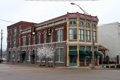 | Bank of Dyersburg | building | 1983 | 83003030 |
| Bruce High School | building | 2023 | 100009096 | |
| Cole-Boston House | building | 2025 | 100012392 | |
| Dyersburg Courthouse Square Historic District | district | 1991 | 91000222 | |
| Gordon-Oak Streets Historic District | district | 1992 | 92000428 | |
 | Edward Moody King House | building | 1990 | 90001658 |
| Latta House | building | 1978 | 78002586 | |
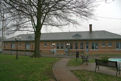 | Newbern Illinois Central Depot | building | 1993 | 93000213 |
| Pleasant Hill Cemetery | site | 2003 | 03001159 | |
| Troy Avenue Historic District | district | 1992 | 92000429 |
Every wildfire the federal occurrence database records inside this county: 328 of them, burning about 1,986 acres. 3 started naturally and 44 were recorded as arson. Each settlement page carries the fires within five miles of it.
| Reported cause | Fires |
|---|---|
| Debris and open burning | 193 |
| Arson/incendiarism | 44 |
| Equipment and vehicle use | 38 |
| Missing data/not specified/undetermined | 21 |
| Power generation/transmission/distribution | 12 |
| Misuse of fire by a minor | 8 |
| Railroad operations and maintenance | 7 |
| Natural | 3 |
| Smoking | 1 |
| Other causes | 1 |
The five largest, by the area the report gives. Two of them were set deliberately.
| Date | Cause | Size | Reported by | Name on the report |
|---|---|---|---|---|
| 2 March 2006 | Debris and open burning | 400 acres | Tennessee Division of Forestry | not named |
| 28 October 2000 | Debris and open burning | 169 acres | Tennessee Division of Forestry | not named |
| 8 November 2005 | Debris and open burning | 75 acres | Tennessee Division of Forestry | not named |
| 9 November 2010 | Arson/incendiarism | 53 acres | Tennessee Division of Forestry | TIGRETT TRAIL |
| 2 October 1998 | Debris and open burning | 53 acres | Tennessee Division of Forestry | not named |
| 5 April 2010 | Debris and open burning | 46 acres | Tennessee Division of Forestry | PAINT CAN |
| 10 November 2014 | Arson/incendiarism | 34 acres | Tennessee Division of Forestry | ANDERSON FARMS 412 |
| 22 October 2010 | Missing data/not specified/undetermined | 32 acres | Tennessee Division of Forestry | GUN FIRE |
Every settlement page carries the fires within five miles of it - see the settlement index below.
The NOAA Storm Events Database holds 263 reports for this county, causing 36 deaths, 147 injuries and about $98,826,850 in recorded property damage. Each settlement page carries the reports that name it.
| Kind of event | Reports |
|---|---|
| Thunderstorm Wind | 138 |
| Hail | 55 |
| Tornado | 33 |
| Flash Flood | 17 |
| Flood | 14 |
| Lightning | 6 |
The most serious of them, by death, then injury, then recorded damage. The accounts are quoted exactly as the forecast office filed them.
| When | Event | Place named | Harm | What the report says |
|---|---|---|---|---|
| April 2006 | Tornado (F3) | Newbern | 16 killed, 70 hurt, $20,000,000 | A tornado spawned from the same parent supercell that produced damaging tornadoes west of the Mississippi River moved across Dyer County during the evening of April 2nd. The most affected areas were Millsfield, Maxey, and Newbern. The F3 tornado resulted in sixteen fatalities and 70 injuries. Seventy-one homes were destroyed and one hundred eighty-two were damaged. |
| March 1952 | Tornado (F3) | not stated | 10 killed, 30 hurt, $250,000 | no account filed |
| March 1952 | Tornado (F4) | not stated | 4 killed, 5 hurt, $250,000 | no account filed |
| March 1952 | Tornado (F4) | not stated | 2 killed, 10 hurt, $250,000 | no account filed |
| April 1998 | Tornado (F3) | Ro Ellen | 2 killed, 3 hurt, $250,000 | The tornado started west of Ro Ellen and moved east. One mobile home with two persons inside was destroyed. The two persons in the mobile home were killed. Two other mobile homes were destroyed. A brick home was destroyed with a truck thrown on top of the house. Several other homes were damaged. Numerous trees and power lines were blown down. Debris from this tornado such as old income tax forms and life insurance policies were found near Dyer, Tennessee in nearby Gibson county. This meant the debris travelled about 15 miles. |
| March 1997 | Tornado (F4) | Chic | 1 killed, 15 hurt, $2,000,000 | no account filed |
| May 2006 | Lightning | Newbern | 1 killed, 1 hurt, $10 | A 37 year old man was killed when lightning struck a tree he was using for a shelter at the Oakview Links Golf Course. A 33 year old man was injured in the same strike and was transported to a hospital in Memphis. |
| May 2003 | Tornado (F2) | Dyersburg | 10 hurt, $50,000,000 | The tornado touched down just southwest of Dyersburg and tracked northeast through the middle of the city. Over 70 homes were destroyed and more than 300 were damaged. Eight commercial buildings were destroyed and nearly 20 were damaged. |
| April 1982 | Tornado (F3) | not stated | 1 hurt, $2,500,000 | no account filed |
| October 2004 | Tornado (F1) | Evansville | 1 hurt, $1,000,000 | The tornado touched down just west of Dyersburg and moved east into the northwest part of the city. Three mobile homes were destroyed. The roof and facade of a manufacturing plant was damaged. Seven other businesses were damaged. Twenty signal lights were destroyed. Many trees, power lines and power poles were blown down. |
| April 1973 | Tornado (F1) | not stated | 1 hurt, $25,000 | no account filed |
| May 2010 | Flood | Dyersburg | $9,500,000 | Heavy rain of 10 to 20 inches produced record breaking flooding along the North Fork Forked Deer River in Dyer County. South Dyersburg was hit extremely hard with numerous homes and businesses sustaining major damage. At one point portions of South Dyersburg was underneath as much as 4 feet of water. In total, at least 600 structures received damage from the flooding. |
| April 2011 | Thunderstorm Wind | Chic | $4,930,000 | Straight line winds caused widespread damage across Dyer County from the Mississippi River through Dyersburg and into Newbern. Forty-four houses, twenty-nine mobile homes, six businesses and nineteen farm buildings were destroyed. Thirty-eight houses, six mobile homes and eight farm buildings suffered major damage. Many trees were also knocked down. |
| April 2025 | Tornado (EF1) | Jenkinsville | $1,900,000 | A tornado touched down near Upper Finley Road on the northwest side of Dyersburg and tracked east-northeast across the northern part of the city. The damage consisted mainly of fallen trees and power lines, minor roof damage, and minor structural damage. Sixteen houses were damaged along with one public building and seven businesses. The tornado lifted near David Road near the Highway 51 and Highway 412 junction. Peak winds were estimated at 100 mph. |
| April 2025 | Flood | Calvary | $1,250,000 | Heavy rain resulted in widespread flooding of the Obion River in Bogota. Nearly 100 structures were affected. |
| April 2025 | Flood | (Dyr)Dyersburg Muni | $750,000 | The North Fork Forked Deer River flooded across the southern part of Dyersburg. Water rescues from homes in South Dyersburg were necessary. Over 100 structures were affected. |
| May 2011 | Flood | Chic | $750,000 | The Mississippi River rose to near record levels during the beginning to middle part of May. A few homes along the river were flooded and sustained damage. Several thousand acres of agriculture fields were flooded. Several roads were flooded and/or damaged. The river remained above flood stage through the end of the month. |
| December 2021 | Tornado (EF2) | Newbern | $650,000 | The first observed damage was in Newbern, Tennesee near Washington Street. A convenience store was heavily damaged. Several outbuildings were damaged in Newbern. The elementary school and an auto shop suffered roof damage. The tornado moved northeast, uprooting and snapping numerous trees along its path, and then moved into Gibson County. Peak winds were estimated at 135 mph in Dyer County. |
| March 2017 | Thunderstorm Wind | Finley | $250,000 | A swath of wind damage occurred from west of Dyersburg into the city of Dyersburg. Trees were snapped along the path and many outbuildings were damaged. In the city of Dyersburg several business suffered minor damage mainly to roofs. Several homes also suffered roof damage. |
| April 2006 | Hail | Dyersburg | $250,000 | Over 250 vehicles were damaged by large hail at three car dealerships in Dyersburg. The hail also caused damage to the metal siding of one of the dealerships. |
| March 1953 | Tornado (F2) | not stated | $250,000 | no account filed |
| April 2008 | Flood | Bishop | $200,000 | Excessive rainfall brought levels of the Forked Deer River to high levels in South Dyersburg. A few homes were flooded as a result. |
| May 2003 | Tornado (F1) | Finley | $200,000 | The tornado touched down just southwest of Finley and tracked northeast. Several houses were damaged or destroyed. |
| April 1996 | Thunderstorm Wind (F0) | Newbern | $200,000 | no account filed |
| December 2007 | Lightning | Dyersburg | $100,000 | Lightning struck the Pierce Lane Church of Christ Church in Dyersburg. The lighnting strike produced a fire that resulted in the church being destroyed. |
| April 1996 | Thunderstorm Wind | Dyersburg | $100,000 | no account filed |
| May 2000 | Thunderstorm Wind | Tennemo | $75,000 | Several trees and power lines were blown down. |
| March 2017 | Tornado (EF0) | Dyersburg | $50,000 | A weak tornado embedded within a line of severe thunderstorms touched down south of the Dyersburg Primary School and tracked east-northeast. The tornado struck a farm on Jones Road tearing the roof off one barn and causing significant damage to another. A house suffered shingle damage and some outbuildings were also damaged. Intermittent tree damage occurred along the path. The tornado lifted at Welch Road. Peak winds were estimated at 80 mph. |
| May 2009 | Flash Flood | Big Boy Jct | $50,000 | Heavy rain produced flash flooding in parts of Dyer County. Flooding occurred along Highway 104 near Finley. Several homes were flooded in Finley. |
| May 2008 | Tornado (EF2) | Chic | $40,000 | A tornado briefly touched down along Chic Road, just west of the Moss Island State Wildlife Management Area. The tornado traveled northeast for roughly one mile, crossing the Great River Road before lifting. A mobile home was destroyed and several power lines were knocked down. |
| February 2018 | Flash Flood | Templeton | $30,000 | Flooded roads between Trimble and New Bern. Possible roads washed out. |
| March 2000 | Lightning | Dyersburg | $30,000 | Lightning damaged the 911 antenna on the Dyersburg Emergency Operations Center. |
| April 2026 | Tornado (EF0) | Dyersburg | $25,000 | A weak, short-lived EF0 tornado touched down on the southeast side of Dyersburg shortly after midnight Tuesday, April 28. The most significant damage occurred at a warehouse on E Court St, where ten skylights were blown out, and a large metal panel was pulled from the side of the building. The tornado continued southeastward almost parallel to E Court Street, causing tree damage on both sides of the road. Minor roof damage was noted at a house on Auburn Ave. The tornado lifted just before reaching U.S. Highway 412. |
| April 2025 | Flood | Trimble | $25,000 | Heavy rain caused flooding along the Rutherford Fork Obion River. Three homes were affected on the Dyer County side of Kenton. |
| May 2022 | Thunderstorm Wind | Dyersburg | $25,000 | Numerous trees down along East Court Street. A tree fell on house damaging the roof. A tree fell on a car as well. |
| May 2003 | Tornado (F1) | Newbern | $25,000 | The tornado touched down just south of Newbern and traveled northeast. Several homes had their roofs blown off. Numerous trees and power lines were knocked down. |
| April 1978 | Tornado (F0) | not stated | $25,000 | no account filed |
| November 1975 | Tornado (F1) | not stated | $25,000 | no account filed |
| June 1957 | Tornado (F1) | not stated | $25,000 | no account filed |
| March 1953 | Tornado (F1) | not stated | $25,000 | no account filed |
| July 2023 | Thunderstorm Wind | Jenkinsville | $20,000 | A tree fell on two vehicles in a parking lot. |
| January 2020 | Thunderstorm Wind | Fowlkes | $20,000 | Numerous trees were uprooted and knocked down in the Fowlkes area. One carport was severely damaged and one home sustained minor roof damage. |
| June 2019 | Thunderstorm Wind | Dyersburg | $20,000 | Tractor trailer blown over on Highway 412 in Dyersburg. |
| February 2018 | Thunderstorm Wind | Newbern | $20,000 | Multiple trees down on highway between New Bern and Trimble. |
| March 2017 | Thunderstorm Wind | Trimble | $20,000 | Large tree down on vehicle near intersection of Church and Mulberry Streets. |
| December 2016 | Thunderstorm Wind | (Dyr)Dyersburg Muni | $20,000 | Trees, power lines and poles down across parts of Dyer County. |
| December 2016 | Thunderstorm Wind | Dyersburg | $20,000 | Large trees uprooted with lots of tree limbs down. One carport roof torn off with home shingle damage and broken windows. |
| January 2008 | Tornado (EF1) | South Fork | $20,000 | This tornado continued from Lauderdale County into Dyer County crossing Highway 210 where trees were snapped and uprooted. The tornado then crossed Holmes Road near the Fowlkes Community. A home suffered minor damage with windows blown out and debris thrown into trees. More trees were snapped. The tornado weakened and continued east-northeast across Pond Creek to Ashley Road where it damaged a mobile home. The tornado then lifted just to the east-northeast and the damage path ended. |
| November 1995 | Thunderstorm Wind | Newbern | $20,000 | A canopy was torn off a car wash. A Sheriff's deputy car was blown into a ditch. Many highway signs were blown down. |
| April 2011 | Flash Flood | (Dyr)Dyersburg Muni | $15,000 | Heavy rain produced flash flooding in Dyersburg. Several streets and county roads were covered by water and two vehicles were flooded. |
| May 2004 | Thunderstorm Wind | Countywide | $15,000 | Numerous trees and power lines were knocked down across the county. |
| April 2025 | Thunderstorm Wind | Nauvoo | $10,000 | The roof was ripped off an outbuilding, and a tree was knocked down. |
| August 2024 | Thunderstorm Wind | Newbern | $10,000 | A large tree was blown on to a vehicle in Newbern. |
| April 2016 | Thunderstorm Wind | Dyersburg | $10,000 | Straight line winds damaged the roof and siding of a home. A privacy fence was downed along with a few trees. |
| November 2007 | Thunderstorm Wind | (Dyr)Dyersburg Muni | $10,000 | Straight line winds knocked down several trees on Key Corner Road near Unionville. In addition, power poles and power lines were knocked down near the Dyersburg Airport. |
| May 2006 | Thunderstorm Wind | Countywide | $10,000 | Trees were knocked down across Dyer County. A few homes in Newbern suffered some damage due to straight line winds. The damage primarily consisted of busted out windows and roof damage. |
| August 2006 | Thunderstorm Wind | Dyersburg | $10,000 | Straight line winds knocked down dozens of trees and several power poles. The downed power lines left 300 homes without power. The hardest hit area occurred in the Miltown and St. John Avenue area of Dyersburg. A tractor-trailor was also blown off U.S. Highway 412 north of the SR 104 exit by the straightline winds. |
| July 2004 | Thunderstorm Wind | Dyersburg | $10,000 | A few trees were blown down on top of a building. |
| June 2004 | Lightning | Dyersburg | $10,000 | Two homes in Dyer county suffered damage after lightning strikes. One of the houses caught on fire. |
| May 2003 | Tornado (F0) | Dyersburg | $10,000 | The tornado touched down just east of Dyersburg and moved northeast. Many trees were blown down. |
The Survey's mineral resources record lists 9 workings inside this county. 4 still produce and 5 are closed or unrecorded. Each settlement page carries the workings within five miles of it.
| Commodity | Workings |
|---|---|
| Sand and Gravel, Construction | 8 |
| Clay | 1 |
The least common of them first, because a county's hundredth gravel pit says nothing its first ten did not.
| Where | Site | Commodity | Status | Recorded |
|---|---|---|---|---|
| Dyersburg Pit | Clay | Past Producer | ||
| Gravel Pit | Sand and Gravel, Construction | Producer | ||
| Horner Pit | Sand and Gravel, Construction | Producer | ||
| Lock Pit | Sand and Gravel, Construction | Producer | Unconsolidated Sediments | |
| Lock Pit | Sand and Gravel, Construction | Past Producer | Sedimentary | |
| Lock Pit | Sand and Gravel, Construction | Past Producer | ||
| Millsfield Pit | Sand and Gravel, Construction | Producer | Unconsolidated Sediments | |
| Millsfield Pit | Sand and Gravel, Construction | Past Producer | Sedimentary | |
| Millsfield Pit | Sand and Gravel, Construction | Past Producer |
Named settlements recorded in the Geographic Names Information System, each with the topographic sheets covering it. Villages, hamlets and abandoned places alike. Each is shown with the nearest named watercourse or landform and the survey quadrangle it falls on.
District 5 · 38030 · Near Towhead of Island Number Eighteen · Cottonwood Point quadrangle
12 sheets, 1939 to 1983
District 1 · 38024 · Near Island Number Five (historical) · Bonicord quadrangle
9 sheets, 1939 to 1986
District 5 · 38030 · On Stake Slough · Cottonwood Point quadrangle
12 sheets, 1939 to 1983
District 1 · 38024 · Near Island Number Five (historical) · Bonicord quadrangle
9 sheets, 1939 to 1986
District 1 · 38024 · Near Island Number Four (historical) · Fowlkes quadrangle
9 sheets, 1939 to 1986
The vanished settlements of Dyer County: the places named above that are no longer on the map.