 Block
From the record
One of 120 National Register listings published here for Knox County · listed in 1984 · category: District.
Sources: the National Register database, National Park Service · the Wikipedia article
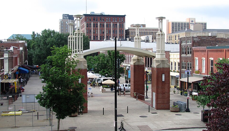
Listed on the National Register of Historic Places in 1984.
One of 120 National Register listings published here for Knox County · listed in 1984 · category: District.
Sources: the National Register database, National Park Service · the Wikipedia article
Regional context, not property-specific evidence. The federal wildfire occurrence database lists 18 fires within 5 miles of Market Square Commercial Historic District between 1999 and 2020, burning about 192 acres in total. 1 started naturally. 6 were recorded as arson. Distance is straight-line from the map coordinates, so a fire counted here may appear on a neighbouring settlement's page as well.
| Reported cause | Fires |
|---|---|
| Arson/incendiarism | 6 |
| Missing data/not specified/undetermined | 2 |
| Recreation and ceremony | 2 |
| Smoking | 2 |
| Debris and open burning | 1 |
| Natural | 1 |
| Equipment and vehicle use | 1 |
| Other causes | 1 |
| Power generation/transmission/distribution | 1 |
| Railroad operations and maintenance | 1 |
The most recent of them, most recent first, with the day each was reported and the service that recorded it.
| Date | Cause | Size | Reported by | Name on the report |
|---|---|---|---|---|
| 2 August 2015 | Smoking | under an acre | Tennessee Division of Forestry | ARBOR PLACE |
| 4 June 2011 | Arson/incendiarism | 4.0 acres | Tennessee Division of Forestry | SMITH EVANS LN |
| 9 April 2009 | Power generation/transmission/distribution | 30 acres | Tennessee Division of Forestry | CHEROKEE TRAIL |
| 5 April 2020 | Debris and open burning | 2.0 acres | Tennessee Division of Forestry | BROWN |
| 23 April 2007 | Railroad operations and maintenance | 100 acres | Tennessee Division of Forestry | SHARPS RIDGE TOWER |
| 14 April 2014 | Recreation and ceremony | 5.0 acres | Tennessee Division of Forestry | LIPPENCOTT |
| 7 March 2000 | Smoking | 2.0 acres | Tennessee Division of Forestry | not named |
| 31 March 2015 | Recreation and ceremony | 1.0 acres | Tennessee Division of Forestry | SHARP RIDGE |
Regional context, not property-specific evidence. The federal mineral resources record lists 82 workings within 5 miles of Market Square Commercial Historic District: 71 past producers, 7 producers, 2 plants, 1 occurrence. 9 still produce. What was taken out: Marble, Dimension, Stone, Crushed/Broken, Limestone, Dimension, Limestone, General. Distance is straight-line from the map coordinates, so a quarry counted here may appear on a neighbouring settlement's page as well.
| Where | Site | Commodity | Status | Recorded |
|---|---|---|---|---|
| Asbury Quarry | Stone, Crushed/Broken, Limestone, High Calcium | Producer | Limestone | |
| City Quarry Knoxville | Stone, Crushed/Broken, Limestone, General | Producer | 1850 | |
| Knoxville Sand & Gravel Plant | Sand and Gravel, Construction | Producer | Unconsolidated Sediments | |
| Lead Prospect | Lead | Occurrence | ||
| O.K. Quarry | Calcium, Limestone, General | Past Producer | Calcite | |
| Williams Quarry | Limestone, High Calcium | Producer | Limestone | |
| Asbury Pit | Calcium | Plant | ||
| Broadway Mine | Clay | Past Producer | Sedimentary | |
| Dixie Lee Quarry | Limestone, General | Past Producer | Sedimentary | |
| Freeway Quarry | Limestone, General | Past Producer | Sedimentary |
Regional context, not property-specific evidence. The National Weather Service names Knoxville, the town this property stands in, in 293 storm reports between 1993 and 2026: 196 thunderstorm wind, 62 hail, 16 flash flood, 14 flood. The reports record 2 deaths. Each account below is quoted exactly as the forecast office filed it, from the NOAA Storm Events Database, and each date opens the federal record of that event.
| When | Event | Place named | Harm | What the report says |
|---|---|---|---|---|
| November 2000 | Thunderstorm Wind | Knoxville | 2 killed, $3,000 | no account filed |
| May 2003 | Flash Flood | Knoxville | $2,800,000 | Kingston Pike and Gleason Road flooded and closed. |
| February 2011 | Flood | Knoxville | $1,960,000 | Broadcast media reported that heavy rain from a thunderstorm caused flooding countywide. |
| May 1996 | Thunderstorm Wind | Knoxville | $500,000 | no account filed |
| May 2003 | Tornado (F1) | Knoxville | $200,000 | no account filed |
| May 2003 | Tornado (F1) | Knoxville | $150,000 | no account filed |
| July 2004 | Thunderstorm Wind | Knoxville | $70,000 | no account filed |
| June 2011 | Tornado (EF0) | West Knoxville | $40,000 | A NWS storm surveyed reported an EF-0 tornado touched along Western Avenue in Knoxville. It had a path length of around 1 mile and a path width of 100 yards. The max wind of 80 mph downed several trees and powerlines along with causing slight roof damage on 2 homes. |
| May 2006 | Thunderstorm Wind | Knoxville | $35,000 | no account filed |
| July 2002 | Thunderstorm Wind | Knoxville | $35,000 | no account filed |
| April 2011 | Thunderstorm Wind | Knoxville | $30,000 | Amateur radio personnel reported several buildings damaged or destroyed by thunderstorm wind at the University of Tennessee hospital property in Knoxville. |
| June 2011 | Thunderstorm Wind | Knoxville | $30,000 | Amateur radio personnel reported numerous trees downed by thunderstorm wind in Knoxville. Wind also downed a tree on a house. |
| April 2011 | Hail | Knoxville | $30,000 | The public reported thunderstorms produced baseball-size hail 2 miles southeast of Knoxville damaging vehicles in the area. |
| July 2004 | Thunderstorm Wind | Knoxville | $30,000 | no account filed |
| April 2011 | Thunderstorm Wind | Knoxville | $25,000 | Amateur radio personnel reported numerous trees downed by thunderstorm wind at the Martha Washington Heights subdivision in Knoxville. |
| August 2006 | Lightning | Knoxville | $25,000 | Lightning struck and damaged an apartment building on Middle Brook Pike in Knoxville. One unit was destroyed as the roof caught fire. |
| July 2006 | Thunderstorm Wind | Knoxville | $25,000 | no account filed |
| May 2004 | Thunderstorm Wind | Knoxville | $25,000 | no account filed |
| July 2022 | Flood | Knoxville | $20,000 | Vehicles submerged along 23rd Street. A few residents were rescued from nearby apartments. |
| June 2011 | Flash Flood | Knoxville | $20,000 | Law enforcement personnel reported heavy rain from thunderstorm caused flooding on many roads across the county. |
| April 2011 | Thunderstorm Wind | Knoxville | $20,000 | Law enforcement personnel reported numerous trees and powerlines downed by thunderstorm wind countywide. |
| June 2009 | Thunderstorm Wind | Knoxville | $20,000 | Law enforcement officials reported numerous trees downed by thunderstorm winds countywide. |
| June 2008 | Thunderstorm Wind | South Knoxville | $20,000 | Dispatch reported several trees downed by thunderstorm winds in the Knoxville area. A tree fell on home in Knoxville damaging the roof. |
| June 2007 | Thunderstorm Wind | Knoxville | $20,000 | Thunderstorm winds downed several trees and powerlines in Knoxville and the surrounding areas. |
| August 2006 | Thunderstorm Wind | Knoxville | $20,000 | Numerous trees and powerlines down across the southeast half of the county. Over 17,000 homes lost power. |
| June 2005 | Thunderstorm Wind | Knoxville | $20,000 | Numerous trees down in city and county-wide. |
| August 2005 | Thunderstorm Wind | Knoxville | $20,000 | Several trees down in and around the Halls Crossroads area. Reported by Knox County Highway Dept. |
| August 2005 | Thunderstorm Wind | Knoxville | $20,000 | A few trees down on powerlines in north Knox County. Reported by Clinton Utilities. |
| August 2005 | Thunderstorm Wind | Knoxville | $20,000 | Numerous trees and powerlines down. |
| October 2005 | Thunderstorm Wind | Knoxville | $20,000 | Numerous trees and powerlines downed across north Knox County. |
| June 2004 | Thunderstorm Wind | Knoxville | $20,000 | Several trees down across east half of county |
| June 2004 | Thunderstorm Wind | Knoxville | $20,000 | Tree down on automobile on Asheville Hwy |
| May 2005 | Thunderstorm Wind | Knoxville | $20,000 | no account filed |
| July 2004 | Thunderstorm Wind | Knoxville | $20,000 | no account filed |
| February 1998 | Thunderstorm Wind | Knoxville | $20,000 | no account filed |
| October 2001 | Thunderstorm Wind | Knoxville | $19,000 | Trees and power lines down. |
| June 2009 | Thunderstorm Wind | West Knoxville | $18,000 | The local television station reported numerous trees downed by thunderstorm winds across the county. A few homes and a church in Knoxville were also damaged by the winds. |
| April 2006 | Thunderstorm Wind | Knoxville | $18,000 | Numerous trees down in Knoxville. |
| June 2006 | Thunderstorm Wind | Knoxville | $18,000 | Several trees and powerlines down in Knoxville. |
| June 2005 | Thunderstorm Wind | Knoxville | $18,000 | One tree down in Knoxville and a few other trees across the rest of the county. |
| June 2005 | Thunderstorm Wind | Knoxville | $18,000 | Several trees and a powerline down in and around the city of Knoxville. |
| December 2005 | Thunderstorm Wind | Knoxville | $18,000 | Several trees down countywide |
| March 2004 | Thunderstorm Wind | Knoxville | $18,000 | no account filed |
| February 2026 | Thunderstorm Wind | South Knoxville | $15,000 | Strips of green tin roof were peeled off an inn on Chapman Highway by severe thunderstorm wind gusts. |
| April 2015 | Thunderstorm Wind | Knoxville | $15,000 | Dispatch personnel reported multiple trees and few powerlines downed by thunderstorm wind across the county. |
| April 2014 | Thunderstorm Wind | Knoxville | $15,000 | Law enforcement personnel reported numerous trees downed by thunderstorm wind countywide. |
| February 2011 | Thunderstorm Wind | Knoxville | $15,000 | Law enforcement personnel reported five trees and two powerlines downed by thunderstorm wind in and around Knoxville. |
| February 2011 | Thunderstorm Wind | Knoxville | $15,000 | A trained spotter reported several trees and a small carport downed by thunderstorm wind six miles north of Knoxville on Conner Drive. |
| June 2011 | Thunderstorm Wind | Knoxville | $15,000 | Amateur radio personnel reported several trees and limbs downed by thunderstorm wind in Knoxville. |
| June 2009 | Thunderstorm Wind | Knoxville | $15,000 | Law enforcement personnel reported several trees and powerlines downed by thunderstorm winds in Knoxville. |
| June 2009 | Thunderstorm Wind | Knoxville | $15,000 | The newspaper reported several trees and powerlines downed by thunderstorm winds in Knoxville. In addition, the roof of a home in Knoxville was damaged by the wind. |
| June 2007 | Thunderstorm Wind | Knoxville | $15,000 | Thunderstorm winds downed four trees in west Knoxville. |
| June 2004 | Thunderstorm Wind | Knoxville | $15,000 | Numerous trees down throughout the city |
| September 1995 | Thunderstorm Wind | Knoxville | $15,000 | A thunderstorm knocked down trees and electrical wires around the Knoxville area. |
| July 2005 | Thunderstorm Wind | Knoxville | $15,000 | no account filed |
| July 2004 | Thunderstorm Wind | Knoxville | $15,000 | no account filed |
| July 2004 | Thunderstorm Wind | Knoxville | $15,000 | no account filed |
| November 2002 | Thunderstorm Wind | North Knoxville | $15,000 | no account filed |
| July 1999 | Thunderstorm Wind | Knoxville | $15,000 | no account filed |
| June 2014 | Thunderstorm Wind | Knoxville | $12,000 | Law enforcement personnel reported many trees downed by thunderstorms wind countywide. |
No historic map-sheet match is published for this property yet. That does not mean no map exists. This record needs a coordinate-quality review before it can be joined to a sheet boundary. Browse the county's mapped places while that work is pending.
Other National Register properties close enough to walk or drive between, ordered by distance from this one. Both positions come from the same geocoding pass that matched these properties to their map sheets.
| Photograph | Property | Distance | Listed |
|---|---|---|---|
 | Mall Building | under 500 feet | 1982 |
 | Holston National Bank | under 500 feet | 1979 |
 | Gay Street Commercial Historic District | under 500 feet | 1986 |
 | Cowan, McClung and Company Building | under 500 feet | 1984 |
 | Mechanics' Bank and Trust Company Building | under 500 feet | 1983 |
 | Old Post Office Building | under 500 feet | 1973 |
| National Archives record | The nomination case file for reference 84001138 in Record Group 79. |
| Wikipedia article | Community-written account of this property, licensed CC BY-SA. |
| Knox County | All 120 listed properties in this county. |