 Block
From the record
One of 5 National Register listings published here for DeKalb County · listed in 1984 · category: Building · built in 1894.
Sources: the National Register database, National Park Service
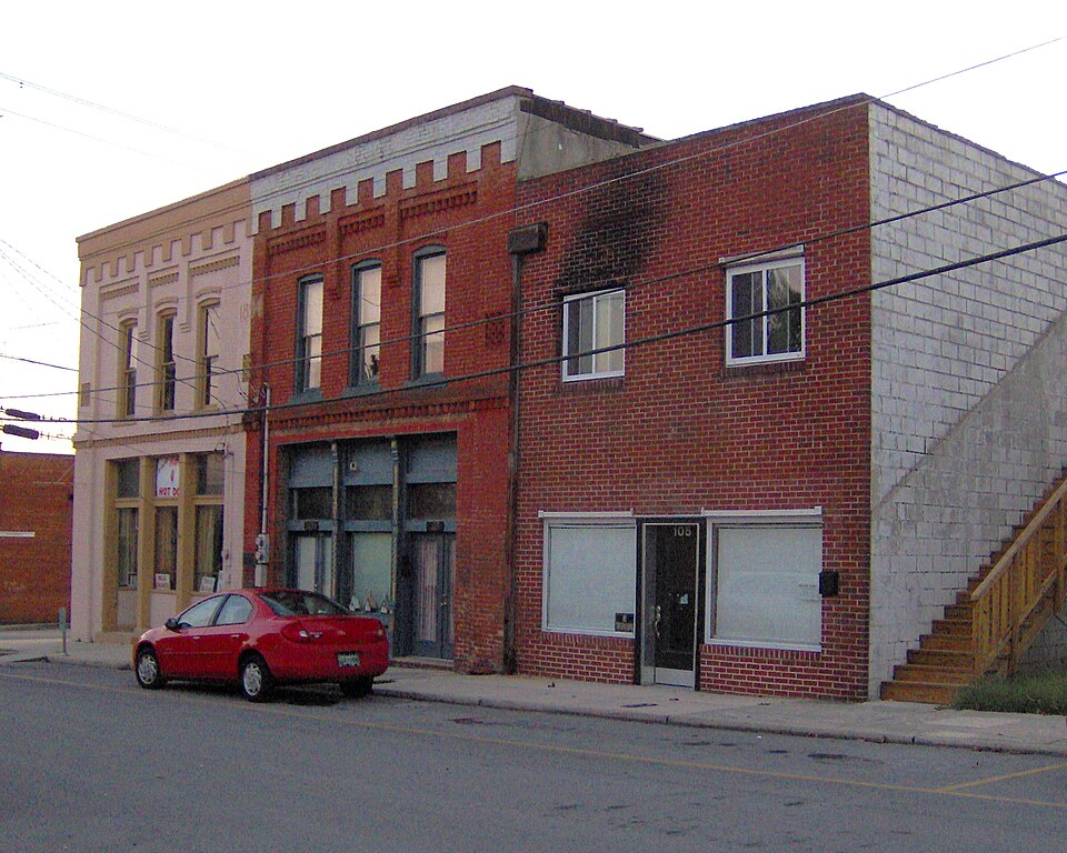
Built in 1894. Listed on the National Register of Historic Places in 1984.
One of 5 National Register listings published here for DeKalb County · listed in 1984 · category: Building · built in 1894.
Sources: the National Register database, National Park Service
Regional context, not property-specific evidence. The federal wildfire occurrence database lists 78 fires within 5 miles of Evans Block between 1997 and 2019, burning about 353 acres in total. None started naturally. 22 were recorded as arson. Distance is straight-line from the map coordinates, so a fire counted here may appear on a neighbouring settlement's page as well.
| Reported cause | Fires |
|---|---|
| Debris and open burning | 41 |
| Arson/incendiarism | 22 |
| Missing data/not specified/undetermined | 8 |
| Smoking | 4 |
| Other causes | 3 |
The most recent of them, most recent first, with the day each was reported and the service that recorded it.
| Date | Cause | Size | Reported by | Name on the report |
|---|---|---|---|---|
| 25 September 2019 | Other causes | under an acre | Tennessee Division of Forestry | COCONUT RIDGE FIRE |
| 25 September 2007 | Arson/incendiarism | under an acre | Tennessee Division of Forestry | SNOW HII |
| 15 September 2010 | Debris and open burning | 6.5 acres | Tennessee Division of Forestry | JACOB`S PILLAR |
| 1 September 1999 | Debris and open burning | 2.0 acres | Tennessee Division of Forestry | not named |
| 6 July 1999 | Arson/incendiarism | under an acre | Tennessee Division of Forestry | not named |
| 24 July 1997 | Arson/incendiarism | 2.0 acres | Tennessee Division of Forestry | not named |
| 9 April 2001 | Smoking | under an acre | Tennessee Division of Forestry | not named |
| 8 April 2008 | Debris and open burning | under an acre | Tennessee Division of Forestry | not named |
Regional context, not property-specific evidence. The federal mineral resources record lists 32 workings within 5 miles of Evans Block: 32 occurrences. None of them still produces. What was taken out: Uranium, Oil Shale, Uranium, Oil Shale, Oil Shale, Uranium. Distance is straight-line from the map coordinates, so a quarry counted here may appear on a neighbouring settlement's page as well.
| Where | Site | Commodity | Status | Recorded |
|---|---|---|---|---|
| Drill Hole For Uranium, Yb-24 | Uranium, Stone, Crushed/Broken | Occurrence | Sedimentary | |
| Outcrop Sample For Uranium, Lc-15 | Uranium, Petroleum (Oil), Oil Shale | Occurrence | Shale | |
| Drill Hole For Uranium, Yb-15 | Oil Shale, Uranium | Occurrence | Shale | |
| Drill Hole For Uranium, Yb-18 | Oil Shale, Uranium | Occurrence | Shale | |
| Drill Hole For Uranium, Yb-22 | Oil Shale, Uranium | Occurrence | Shale | |
| Drill Hole For Uranium, Yb-25 | Oil Shale, Uranium | Occurrence | Shale | |
| Drill Hole For Uranium | Uranium, Oil Shale | Occurrence | ||
| Drill Hole For Uranium | Uranium, Oil Shale | Occurrence | ||
| Outcrop Sample For Uranium | Uranium, Oil Shale | Occurrence | ||
| Outcrop Sample For Uranium | Uranium, Oil Shale | Occurrence |
Regional context, not property-specific evidence. The National Weather Service names Smithville, the town this property stands in, in 71 storm reports between 1993 and 2024: 47 thunderstorm wind, 15 hail, 4 tornado, 3 flash flood. The reports record 1 death. Each account below is quoted exactly as the forecast office filed it, from the NOAA Storm Events Database, and each date opens the federal record of that event.
| When | Event | Place named | Harm | What the report says |
|---|---|---|---|---|
| February 2012 | Tornado (EF1) | Smithville | 1 killed, $500,000 | An EF1 tornado with maximum wind speeds around 95 mph touched down about 1 mile northwest of Smithville along Highway 83, then tracked rapidly east-northeast across Center Hill Lake before ending in western White County about 7 miles northwest of Sparta. A barn was damaged near the beginning of the path, with sheet metal blown across fields and into power lines. Scattered trees were snapped or uprooted and some minor damage to homes occurred on the north side of Smithville as the tornado traveled generally along and just south of Highway 83 and Smithville Highway. A small warehouse-type building was destroyed at Smithville Highway and Pine Grove Road with debris thrown northward into fields. The roof of a barn was blown off and a few homes suffered minor roof damage at Holiday Haven Road and Scott Acres Road. The tornado increased in intensity as it moved along Alpine Drive, with hundreds of trees snapped or uprooted. One home on stilts was knocked down a hillside and destroyed, resulting in one fatality.||The tornado then crossed Center Hill Lake, blowing down hundreds of more trees along the south shore of the lake on Allen Ferry Road, Timber Lane, Back Bone Lane, and Falling Water Road. Several trees fell on homes in this area, resulting in minor to moderate roof damage. Passing just north of the Johnson Chapel Recreation Area, the tornado then continued eastward into White County. |
| May 1995 | Hail | Smithville | $1,500,000 | Golf ball-size hail produced significant damage to Smithville and other parts of DeKalb County. Several homes, businesses, and automobiles were damaged. |
| June 1998 | Hail | Smithville | $750,000 | Golf ball size hail was reported. News article mentioned 70 cars and 17 homes were damaged by the hailstorm. The wind driven hailstones caused holes in the siding of homes. |
| May 1995 | Thunderstorm Wind | Smithville | $500,000 | Two business and six homes were damaged. Fifteen outbuildings and barns were also damaged. Several trees and power lines were knocked down. |
| May 2024 | Tornado (EF1) | Smithville | $300,000 | An EF1 tornado touched down east of Highway 70 in northwest Smithville then moved east paralleling Allen Ferry Road. Numerous trees were broken, snapped, and uprooted along the road, and several farm buildings lost roofing. The tornado then curved southeast and caused the worst damage along Highway 56 north of Smith Road where dozens of trees were snapped and uprooted and a couple homes suffered significant roof, garage, and exterior wall damage. The tornado then lifted east of the highway. Damages are a rough estimate. |
| January 1997 | Tornado (F2) | Smithville | $250,000 | no account filed |
| June 2009 | Thunderstorm Wind | Smithville | $125,000 | A two story barn destroyed along with roof blown of building. Type of building was unkown. Newspaper reported that barn was violently thrown, sending splintered wood piercing through the roof of a home and other debris scattered across the property. The roof of the barn was blown over a house nearby. Debris was found across Robinson Road and into an adjacent field. The flying debris and winds damaged the back corner of this home also and destroyed its carport. Two vehicles were damaged in the activity also. Type and amount of damage to vehicles was unkown. |
| May 2011 | Tornado (EF0) | Smithville | $100,000 | A brief tornado occurred in Smithville. It severely damaged a gas station building but the canopy remained intact. It also damaged a nearby restaurant. Many trees were also snapped or uprooted. Specific details on how much damage occurred to the restaurant where unknown. |
| May 2020 | Thunderstorm Wind | Smithville | $71,900 | Numerous trees and power lines were blown down across DeKalb County. |
| April 2006 | Lightning | Smithville | $20,000 | Lightning sturck Pirtle Nursey on Bright Hill Rd. Firefighters put out the fire at the employee's barracks. The fire statrted in the central heating and air unit in the building by the lightning bolt. The blaze burnt itself out. Five hours later, another blaze erupted and burned the barracks to the ground. Fire officials believed that an electrical short caused the fire, and that the electrical short was possibly a result of the earlier lightning strike. |
| May 2003 | Hail | Smithville | $20,000 | News story about hail the size of golf balls breaking 4 windows to a home on Short Mountain Street and putting small dents in automobiles. |
| February 2012 | Thunderstorm Wind | Smithville | $15,000 | An NWS Storm Survey found a half mile wide by 11 mile long swath of wind damage associated with the rear flank downdraft south of the EF1 Smithville Tornado. Roof and siding damage occurred to the DeKalb Middle School, and windows were blown out of the adjacent DeKalb Vocational School. The nearby sports field scoreboards were damaged or blown down. Several trees were blown down along the rest of the path across the north side of Smithville and along the south side of Center Hill Lake. |
| May 2009 | Thunderstorm Wind | Smithville | $12,000 | Several trees were reported blown down. |
| April 2009 | Thunderstorm Wind | Smithville | $10,000 | Only a few trees were reported down with the storm as it moved through DeKalb County. However, one tree which fell across power lines on West Broad Street caused a large power outage throughout many areas of the city. |
| July 2002 | Lightning | Smithville | $10,000 | A newspaper article reported that lightning struck the Dekalb County Sheriff's Department through the 911-radio antenna. The bolt knocked out several computer systems and phone lines. Lightning also struck a barn near Liberty, causing a fire. The barn was completely destroyed. |
| May 2021 | Thunderstorm Wind | Smithville | $5,000 | Trees were blown down with some minor roof damage to buildings in Smithville. |
| March 2020 | Thunderstorm Wind | Smithville | $5,000 | A power pole was snapped and 4 large oak trees were blown down. |
| June 2019 | Thunderstorm Wind | Smithville | $5,000 | Trees and power lines were blown down across De Kalb County. |
| April 2015 | Thunderstorm Wind | Smithville | $5,000 | A few trees were blown down across DeKalb County. |
| January 2008 | Thunderstorm Wind | Smithville | $5,000 | Trees and power lines were down. |
| March 2008 | Thunderstorm Wind | Smithville | $5,000 | Trees were blown down. |
| April 2006 | Thunderstorm Wind | Smithville | $5,000 | Strong thunderstorm wind gusts blew down a shed. Also, part of a roof was blown off a house by the strong winds. |
| June 1995 | Thunderstorm Wind | Smithville | $5,000 | Several trees were blown down. |
| July 1995 | Thunderstorm Wind | Smithville | $5,000 | Several power lines and large tree limbs were knocked down. |
| August 1993 | Thunderstorm Wind | Smithville | $5,000 | Numerous trees were knocked down. |
| May 2017 | Thunderstorm Wind | Smithville | $3,000 | Facebook and Twitter photos showed numerous trees were blown down in and around Smithville. |
| June 2016 | Thunderstorm Wind | Smithville | $3,000 | Trees downed and street signs blown over. |
| February 2008 | Thunderstorm Wind | Smithville | $3,000 | Trees were down. |
| July 2020 | Thunderstorm Wind | Smithville | $2,000 | Two trees were blown down. |
| April 2006 | Thunderstorm Wind | Smithville | $2,000 | Winds lifted a roof off a garage and placed it in front of the Smithville Police Department on East Church Street. Large trees were down. A large marquee sign was lifted off the ground and was blown through the window of a "Gateway to Beauty" store on West Broad Street. In the town of Liberty, large tree limbs were down. Aslo, there were reports according to the newspaper of tree limbs down from Temperance Hall to Short Mountain. |
| July 1995 | Thunderstorm Wind | Smithville | $2,000 | A couple of trees were knocked down. |
| May 1995 | Thunderstorm Wind | Smithville | $1,000 | A few large trees limbs were knocked down. |
| February 1993 | Thunderstorm Wind | Smithville | $500 | Several trees were knocked down. |
| May 1996 | Thunderstorm Wind | Smithville | $100 | no account filed |
| April 2017 | Hail | Smithville | - | Photos showed hail up to quarter size in Smithville. |
| April 2017 | Hail | Smithville | - | Penny size hail was reported 2 miles north of Smithville. |
| May 2013 | Hail | Smithville | - | A trained spotter reported one inch diameter hail in the city of Smithville. |
| April 2009 | Hail | Smithville | - | Quarter size hail was reported in Smithville. |
| March 2006 | Thunderstorm Wind | Smithville | - | Large tree limbs were down on Highway 146. |
| April 2006 | Thunderstorm Wind | Smithville | - | Trees were down. |
| April 2006 | Hail | Smithville | - | Quarter size hail reported on Highway 288. |
| April 2006 | Thunderstorm Wind | Smithville | - | 2 power poles and trees were down. |
| April 2006 | Hail | Smithville | - | Quarter size hail on Cecil Hill Road in southwest part of Dekalb County along Highway 146. |
| June 2006 | Thunderstorm Wind | Smithville | - | 911 Center reported a utility pole was down in Smithville. 3 trees were down in the southeast part of the county on Highway 56 south. |
| July 2005 | Thunderstorm Wind | Smithville | - | Trees were down. |
| June 2005 | Thunderstorm Wind | Smithville | - | Small trees were down around the Center Hill Lake area. |
| December 2004 | Thunderstorm Wind | Smithville | - | A tree was down on Evans Mill Rd. |
| June 2004 | Hail | Smithville | - | Penny size hail was reported. |
| June 2004 | Hail | Smithville | - | Penny size hail was reported. |
| May 2004 | Hail | Smithville | - | Penny size hail was observed. |
| May 2004 | Thunderstorm Wind | Smithville | - | Tree down on U.S. Highway 70. |
| July 2004 | Thunderstorm Wind | Smithville | - | Trees down in western and southern parts of County. |
| July 2004 | Thunderstorm Wind | Smithville | - | Numerous trees were blown down in Smithville. |
| March 2003 | Flash Flood | Smithville | - | EMA office reported water over roads and streets in Smithville. |
| May 2003 | Hail | Smithville | - | Spotter reported penny size hail. |
| September 2003 | Flash Flood | Smithville | - | Local Police Department reported 6 to 12 inches of water on roads. |
| November 2002 | Thunderstorm Wind | Smithville | - | Law enforcement reported trees down. |
| May 2002 | Thunderstorm Wind | Smithville | - | TDOT reported 2 or 3 trees down. |
| July 2002 | Thunderstorm Wind | Smithville | - | Police reported trees were down. A large, 80-year-old pecan tree was blown onto a home near Alexandria. |
| August 2002 | Flash Flood | Smithville | - | Newspaper story reported that southern DeKalb county got hit with very heavy rains, some areas with over 5 inches of rain in one hour. Several local motorists found themselves stranded in their vehicles as they waited for swollen streams and creeks to recede in their banks. A school bus was trapped on Bright Hill Road between rapidly moving waters across the roadway and a downed tree and power lines. Emergency personnel had to rescue occupants of a car on Bright Hill Road and push the small car out of the swift moving water. There were no injuries. |
No historic map-sheet match is published for this property yet. That does not mean no map exists. This record needs a coordinate-quality review before it can be joined to a sheet boundary. Browse the county's mapped places while that work is pending.
Other National Register properties close enough to walk or drive between, ordered by distance from this one. Both positions come from the same geocoding pass that matched these properties to their map sheets.
| Photograph | Property | Distance | Listed |
|---|---|---|---|
| Susie Foster Log House | 0.8 miles | 2007 |
| National Archives record | The nomination case file for reference 84003533 in Record Group 79. |
| DeKalb County | All 5 listed properties in this county. |