 Block
From the record
5 National Register listings published here.
Sources: the county history on the Internet Archive · the National Register database, National Park Service
59 topographic sheets cover 33 settlements here, and 5 properties are on the National Register of Historic Places.
5 National Register listings published here.
Sources: the county history on the Internet Archive · the National Register database, National Park Service
Every property in this county listed on the National Register of Historic Places, with the year it was listed and the federal nomination document.
| Photograph | Property | Type | Listed | Reference |
|---|---|---|---|---|
| Alexandria Cemeteries Historic District | district | 2002 | 02000584 | |
| Dekalb County Fairgrounds | building | 1995 | 95001372 | |
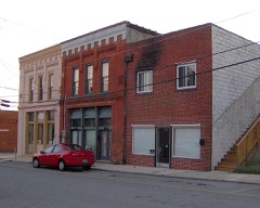 | Evans Block | building | 1984 | 84003533 |
| Susie Foster Log House | building | 2007 | 07000665 | |
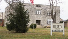 | Liberty Historic District | district | 1987 | 87001058 |
Every wildfire the federal occurrence database records inside this county: 287 of them, burning about 1,632 acres. 3 started naturally and 95 were recorded as arson. Each settlement page carries the fires within five miles of it.
| Reported cause | Fires |
|---|---|
| Debris and open burning | 127 |
| Arson/incendiarism | 95 |
| Missing data/not specified/undetermined | 27 |
| Smoking | 11 |
| Other causes | 10 |
| Equipment and vehicle use | 8 |
| Power generation/transmission/distribution | 4 |
| Natural | 3 |
| Misuse of fire by a minor | 1 |
| Recreation and ceremony | 1 |
The five largest, by the area the report gives. Five of them were set deliberately.
| Date | Cause | Size | Reported by | Name on the report |
|---|---|---|---|---|
| 7 November 2001 | Arson/incendiarism | 178 acres | Tennessee Division of Forestry | not named |
| 21 November 2019 | Debris and open burning | 82 acres | Tennessee Division of Forestry | JACOBS PILLAR RD. |
| 4 November 2020 | Missing data/not specified/undetermined | 60 acres | Tennessee Division of Forestry | PEA RIDGE |
| 2 November 2020 | Missing data/not specified/undetermined | 60 acres | Tennessee Division of Forestry | DEKALB CO. HERMAN RD |
| 14 February 2011 | Arson/incendiarism | 57 acres | Tennessee Division of Forestry | HILL FIRE |
| 27 September 1999 | Arson/incendiarism | 50 acres | Tennessee Division of Forestry | not named |
| 12 November 2005 | Arson/incendiarism | 50 acres | Tennessee Division of Forestry | not named |
| 26 February 1998 | Arson/incendiarism | 42 acres | Tennessee Division of Forestry | not named |
Every settlement page carries the fires within five miles of it - see the settlement index below.
The NOAA Storm Events Database holds 210 reports for this county, causing 1 death, 22 injuries and about $6,301,000 in recorded property damage. Each settlement page carries the reports that name it.
| Kind of event | Reports |
|---|---|
| Thunderstorm Wind | 129 |
| Hail | 39 |
| Flash Flood | 19 |
| Tornado | 15 |
| Lightning | 5 |
| Flood | 1 |
| Heavy Rain | 1 |
| Funnel Cloud | 1 |
The most serious of them, by death, then injury, then recorded damage. The accounts are quoted exactly as the forecast office filed them.
| When | Event | Place named | Harm | What the report says |
|---|---|---|---|---|
| February 2012 | Tornado (EF1) | Smithville | 1 killed, $500,000 | An EF1 tornado with maximum wind speeds around 95 mph touched down about 1 mile northwest of Smithville along Highway 83, then tracked rapidly east-northeast across Center Hill Lake before ending in western White County about 7 miles northwest of Sparta. A barn was damaged near the beginning of the path, with sheet metal blown across fields and into power lines. Scattered trees were snapped or uprooted and some minor damage to homes occurred on the north side of Smithville as the tornado traveled generally along and just south of Highway 83 and Smithville Highway. A small warehouse-type building was destroyed at Smithville Highway and Pine Grove Road with debris thrown northward into fields. The roof of a barn was blown off and a few homes suffered minor roof damage at Holiday Haven Road and Scott Acres Road. The tornado increased in intensity as it moved along Alpine Drive, with hundreds of trees snapped or uprooted. One home on stilts was knocked down a hillside and destroyed, resulting in one fatality.||The tornado then crossed Center Hill Lake, blowing down hundreds of more trees along the south shore of the lake on Allen Ferry Road, Timber Lane, Back Bone Lane, and Falling Water Road. Several trees fell on homes in this area, resulting in minor to moderate roof damage. Passing just north of the Johnson Chapel Recreation Area, the tornado then continued eastward into White County. |
| April 1974 | Tornado (F3) | not stated | 20 hurt, $250,000 | no account filed |
| April 1968 | Tornado (F1) | not stated | 1 hurt, $250,000 | no account filed |
| January 1997 | Tornado (F2) | Alexandria | 1 hurt, $5,000 | no account filed |
| May 1995 | Hail | Smithville | $1,500,000 | Golf ball-size hail produced significant damage to Smithville and other parts of DeKalb County. Several homes, businesses, and automobiles were damaged. |
| June 1998 | Hail | Smithville | $750,000 | Golf ball size hail was reported. News article mentioned 70 cars and 17 homes were damaged by the hailstorm. The wind driven hailstones caused holes in the siding of homes. |
| May 1995 | Thunderstorm Wind | Smithville | $500,000 | Two business and six homes were damaged. Fifteen outbuildings and barns were also damaged. Several trees and power lines were knocked down. |
| May 2024 | Tornado (EF1) | Smithville | $300,000 | An EF1 tornado touched down east of Highway 70 in northwest Smithville then moved east paralleling Allen Ferry Road. Numerous trees were broken, snapped, and uprooted along the road, and several farm buildings lost roofing. The tornado then curved southeast and caused the worst damage along Highway 56 north of Smith Road where dozens of trees were snapped and uprooted and a couple homes suffered significant roof, garage, and exterior wall damage. The tornado then lifted east of the highway. Damages are a rough estimate. |
| May 2003 | Thunderstorm Wind | Countywide | $300,000 | Newspaper related story of many trees blown down, trees on homes and cars and trees blocking roads. A half dozen or more homes were damaged. There were downed trees and power lines as well. The hardest hit area was the eastern part of the county at Ragland Bottom and Hillcrest Hills. 38 homes were damaged in Dekalb County. |
| January 1997 | Tornado (F2) | Smithville | $250,000 | no account filed |
| May 1984 | Tornado (F1) | not stated | $250,000 | no account filed |
| April 1971 | Tornado (F3) | not stated | $250,000 | no account filed |
| June 2009 | Thunderstorm Wind | Smithville | $125,000 | A two story barn destroyed along with roof blown of building. Type of building was unkown. Newspaper reported that barn was violently thrown, sending splintered wood piercing through the roof of a home and other debris scattered across the property. The roof of the barn was blown over a house nearby. Debris was found across Robinson Road and into an adjacent field. The flying debris and winds damaged the back corner of this home also and destroyed its carport. Two vehicles were damaged in the activity also. Type and amount of damage to vehicles was unkown. |
| December 2015 | Tornado (EF1) | Helton | $100,000 | This EF2 tornado touched down on Helton Creek just southwest of Dry Branch Road. At this location, the path width was narrow at 50-75 yards wide but snapped numerous trees and did some minor roof damage to a home. The tornado continued to the east-northeast snapping large trees and doing minor roof damage to a home on Corley Road. As the tornado crossed over TN Highway 264 and Smith Fork Creek it widened to 250 yards. It was here where it produced the greatest damage. The roof and two exterior walls were removed, along with its carport and 2 covered porches. Based on the exterior walls only being toe-nailed in place, it was decided that the maximum wind speed would be reduced slightly to a maximum of 125 mph. The tornado continued east-northeast destroying a cinder block garage and causing moderate roof damage to a log cabin home on Maynard Hollow Lane. At the end of the path, the tornado snapped numerous trees in Lancaster where the path width had narrowed to 100 yards. No damage was found beyond Lancaster.||This is the first tornado on record to occur in both DeKalb County and Smith County in the month of December. |
| May 2011 | Tornado (EF0) | Smithville | $100,000 | A brief tornado occurred in Smithville. It severely damaged a gas station building but the canopy remained intact. It also damaged a nearby restaurant. Many trees were also snapped or uprooted. Specific details on how much damage occurred to the restaurant where unknown. |
| May 2020 | Thunderstorm Wind | Smithville | $71,900 | Numerous trees and power lines were blown down across DeKalb County. |
| April 2023 | Thunderstorm Wind | Evins Mill | $50,000 | A Twitter user reported damage just east of Smithville along Highway 70 and Adcock Cemetery Road that included downed and uprooted trees, roof damage, siding peeled from a barn, and busted windows. Damages are a rough estimate. |
| February 2012 | Thunderstorm Wind | Buckners | $30,000 | Inflow into the north side of the EF1 Smithville tornado caused damage along portions of Ponder Road and Ponder Lane. A few homes suffered minor roof damage, and one home lost a porch awning. Numerous trees were snapped or uprooted, with one tree falling onto and destroying a garage. |
| May 2009 | Flash Flood | Alexandria | $30,000 | Heavy downpours caused creeks and streams to flow out of their banks, causing some|flooding and hazardous driving on local roadways due to flash flooding. In Alexandria the waters rose to cover the DeKalb County Fairgrounds, as well as making some vehicles and trailers in the area having at least three feet of water depth surrounding|them. A small bridge in the Tramel Branch area of DeKalb County was also overrun with flooding waters. |
| May 2021 | Tornado (EF0) | Smithville Muni Arpt | $25,000 | This high-end EF-0 tornado touched down along Coconut Ridge Road north of Smithville, blowing down several trees. Moving southeast, the tornado continued to blow down dozens of trees as it crossed Big Hurricane Road and Highway 56. The tornado then moved along and just south of Holiday Haven Road, damaging several homes and barns and continuing to blow down trees. The tornado knocked down more trees as it passed across Eagle Creek and Johnson Ridge Road before lifting on Center Hill Lake. The path of this tornado was visible on Sentinel satellite imagery. |
| November 2018 | Tornado (EF1) | Mt Morriah | $25,000 | This EF-1 tornado began southeast of Auburntown in northern Cannon County on Hurricane Creek Road. The tornado then traveled east-northeast up and down several different large hills and hollows causing sporadic damage to trees. The worst damage occurred on Dutton Hollow Road, where a carport and well-built taxidermy barn were completely destroyed, and numerous trees were snapped and uprooted. The tornado then crossed into DeKalb County and caused additional tree damage on Highway 53. A house on Clear Fork Road sustained damage to the roof and wood siding, and the steeple on the nearby Cave Springs Missionary Baptist Church was damaged. After the tornado traveled through more hollows and hills causing additional tree damage, it finally lifted near Vandergriff Hollow Road. The total path length of the tornado across Cannon and De Kalb Counties was 8.82 miles. |
| August 2014 | Thunderstorm Wind | Alexandria | $25,000 | A large downburst with winds estimated up to 75 mph struck the Alexandria area. Extensive roof damage was reported to buildings along east Main Street and to structures at the De Kalb County Fairgrounds. Numerous trees and power lines were also blown down. |
| July 2012 | Thunderstorm Wind | Center Hill Lake | $25,000 | Trees and power lines were downed and minor structural damage to docks at Center Hill Lake. Several trees were also downed along U.S. Highway 70. |
| February 2011 | Thunderstorm Wind | Smithville Muni Arpt | $25,000 | Trees were blown down and blocked area roadways. |
| May 2011 | Thunderstorm Wind | Smithville Muni Arpt | $25,000 | Numerous trees and power lines were downed in several areas across the county. |
| May 2009 | Flash Flood | Alexandria | $25,000 | Over five inches fell in most part of DeKalb County, causing swollen creek banks, water-covered roadways, and localized flash flooding. |
| August 1980 | Tornado (F1) | not stated | $25,000 | no account filed |
| July 2023 | Thunderstorm Wind | Phillippi | $20,000 | Severe thunderstorm winds downed a large tree near Midway Road and Terrell Road in Smithville. Other downed trees and powerlines were reported across Dekalb County. Damages are a rough estimate. |
| November 2017 | Flash Flood | Alexandria | $20,000 | Major flash flooding affected much of De Kalb County, with the flooding considered the worst since 1999 in the western part of the county. Numerous roads were covered by water and closed, including Highway 264, Highway 56, Highway 70, Smith Fork Road, Dismal Road, and Main Street in Liberty. Nine water rescues were conducted by emergency personnel in and near Dowelltown. Flood waters surrounded many homes and other buildings, including De Kalb West Elementary School and Salem Baptist Church. A USGS river gauge on Highway 264 at Smith Fork Creek crested at 27.5 feet, the second highest level on record. |
| July 2014 | Thunderstorm Wind | Phillippi | $20,000 | Numerous trees reported down across roadways in area of Cookeville Highway and Pine Grove Road with several homes damaged. |
| April 2006 | Lightning | Smithville | $20,000 | Lightning sturck Pirtle Nursey on Bright Hill Rd. Firefighters put out the fire at the employee's barracks. The fire statrted in the central heating and air unit in the building by the lightning bolt. The blaze burnt itself out. Five hours later, another blaze erupted and burned the barracks to the ground. Fire officials believed that an electrical short caused the fire, and that the electrical short was possibly a result of the earlier lightning strike. |
| May 2003 | Hail | Smithville | $20,000 | News story about hail the size of golf balls breaking 4 windows to a home on Short Mountain Street and putting small dents in automobiles. |
| April 2003 | Thunderstorm Wind | Alexandria | $20,000 | Newspaper article stated several homes, barns and outbuildings sustained roof damage from strong thunderstorm winds from Coon Branch Road to Pumpkin Hollow Road. A large tree fell on a house on Old Liberty Road. A garage behind the home was totally destroyed. |
| May 2021 | Tornado (EF0) | Alexandria | $15,000 | This small, brief tornado touched down on the south side of Alexandria. Security cameras at a home on Old Liberty Road captured the tornado on video as the roof and back porch were blown off the house. The tornado is estimated to have lifted east of Nashville Highway. |
| August 2014 | Thunderstorm Wind | Helton | $15,000 | A house and barn both lost part of their roofs with a tree also falling onto the house on Lower Helton Road. Several other trees were blown down in the area. |
| August 2014 | Thunderstorm Wind | Smithville Muni Arpt | $15,000 | Numerous trees and power lines were blown down all across De Kalb County including in Smithville. |
| February 2012 | Thunderstorm Wind | Smithville | $15,000 | An NWS Storm Survey found a half mile wide by 11 mile long swath of wind damage associated with the rear flank downdraft south of the EF1 Smithville Tornado. Roof and siding damage occurred to the DeKalb Middle School, and windows were blown out of the adjacent DeKalb Vocational School. The nearby sports field scoreboards were damaged or blown down. Several trees were blown down along the rest of the path across the north side of Smithville and along the south side of Center Hill Lake. |
| May 2009 | Thunderstorm Wind | Smithville | $12,000 | Several trees were reported blown down. |
| July 2023 | Thunderstorm Wind | Laurel Hill | $10,000 | A severe thunderstorm downed several trees in the Edgar Evans State Park and Center Hill Dam area. Minor metal roof damage to the Marina was also reported. Damages are a rough estimate. |
| July 2023 | Thunderstorm Wind | Evins Mill | $10,000 | Thunderstorm winds damaged a barn's metal roof along Four Seasons Road in Smithville. Damages are a rough estimate. |
| August 2023 | Thunderstorm Wind | Pisgah | $10,000 | Severe thunderstorm winds downed large tree branches and a few trees in southwest portions of DeKalb County. Damages are a rough estimate. |
| March 2020 | Thunderstorm Wind | Shining Rock | $10,000 | Part of the sheet metal roof of a gas station was blown off and across Highway 56 into a home at Old Blue Springs Road. The gas station sign was also damaged and a power pole was snapped. |
| March 2017 | Thunderstorm Wind | Alexandria | $10,000 | TEMA reported four houses received some roof damage and trees were blown down in Alexandria. |
| January 2013 | Thunderstorm Wind | Smithville Muni Arpt | $10,000 | A few trees were downed across the county. |
| July 2012 | Thunderstorm Wind | Smithville Muni Arpt | $10,000 | Several trees were downed across western portions of the county. |
| May 2010 | Thunderstorm Wind | Evins Mill | $10,000 | Several trees were downed along Bright Hill Road just southeast of Smithville. |
| July 2010 | Thunderstorm Wind | Center Hill Lake | $10,000 | Trees were downed just northwest of Hurricane Ridge Road in Edgar Evins State Park. |
| April 2009 | Thunderstorm Wind | Smithville | $10,000 | Only a few trees were reported down with the storm as it moved through DeKalb County. However, one tree which fell across power lines on West Broad Street caused a large power outage throughout many areas of the city. |
| July 2009 | Lightning | Cherry Hill | $10,000 | Lightning struck a three story home at 2225 Austin Bottom Road, causing a blaze in the basement of the home. Details concerning amount of damage to basement of home unknown. No one was injured. |
| July 2009 | Lightning | Alexandria | $10,000 | A house fire was the result of a lightning strike at 128 Smith Lane. The bolt of lightning struck the side of the house. The bolt hit the phone and electric lines and actually blew a two-foot wide by six-inch deep hole in the yard. Several fire crews arrived on the scene and found the home with thick smoke and fire smoldering in the walls of the home. Firefighters used axes and saws to cut the walls out in order to reach the blaze.|Though the home suffered some smoke and water damage, the house and all of its contents were saved. No injuries were reported during the incident. |
| September 2009 | Thunderstorm Wind | Bethel | $10,000 | Trees were blown down on Banks-Pisgah Road. |
| July 2002 | Lightning | Smithville | $10,000 | A newspaper article reported that lightning struck the Dekalb County Sheriff's Department through the 911-radio antenna. The bolt knocked out several computer systems and phone lines. Lightning also struck a barn near Liberty, causing a fire. The barn was completely destroyed. |
| April 2025 | Thunderstorm Wind | Temperance Hall | $5,000 | Severe thunderstorm winds downed a few trees on Hickman Road near Dowelltown. Damages are a rough estimate. |
| July 2024 | Thunderstorm Wind | Alexandria | $5,000 | Severe thunderstorm winds downed a small tree onto a home in the Temperance Hall area. Damages are a rough estimate. |
| May 2021 | Thunderstorm Wind | Smithville | $5,000 | Trees were blown down with some minor roof damage to buildings in Smithville. |
| March 2020 | Thunderstorm Wind | Smithville | $5,000 | A power pole was snapped and 4 large oak trees were blown down. |
| March 2020 | Thunderstorm Wind | Peeled Chestnut | $5,000 | Light poles were blown down and metal siding blown off a building on Billings Road. |
| June 2019 | Thunderstorm Wind | Smithville | $5,000 | Trees and power lines were blown down across De Kalb County. |
| July 2016 | Thunderstorm Wind | Dismal | $5,000 | A large equipment barn and several trees were blown down near Alexandria. |
| April 2015 | Thunderstorm Wind | Smithville | $5,000 | A few trees were blown down across DeKalb County. |
The Survey's mineral resources record lists 105 workings inside this county. 4 still produce and 101 are closed or unrecorded. Each settlement page carries the workings within five miles of it.
| Commodity | Workings |
|---|---|
| Uranium, Oil Shale | 59 |
| Uranium | 29 |
| Oil Shale | 29 |
| Oil Shale, Uranium | 6 |
| Stone, Crushed/Broken, Limestone, General | 2 |
| Stone, Crushed/Broken | 2 |
| Barium-Barite | 2 |
| Fluorine-Fluorite, Sulfur, Zinc | 2 |
| Barium-Barite, Lead | 2 |
| Fluorine-Fluorite, Barium-Barite, Lead, Zinc, Sulfur-Pyrite | 1 |
| Uranium, Stone, Crushed/Broken | 1 |
| Petroleum (Oil), Oil Shale | 1 |
| Lead, Zinc, Fluorine-Fluorite, Barium-Barite, Sulfur-Pyrite | 1 |
| Fluorine-Fluorite, Zinc | 1 |
The least common of them first, because a county's hundredth gravel pit says nothing its first ten did not.
| Where | Site | Commodity | Status | Recorded |
|---|---|---|---|---|
| Drill Hole For Uranium, Yb-24 | Uranium, Stone, Crushed/Broken | Occurrence | Sedimentary | |
| Dry Creek Prospect | Lead, Zinc, Fluorine-Fluorite, Barium-Barite, Sulfur-Pyrite | Occurrence | 1890 | |
| Frazier Hollow Prospect | Barium-Barite, Fluorine-Fluorite, Zinc | Prospect | ||
| Outcrop Sample For Uranium, Lc-15 | Uranium, Petroleum (Oil), Oil Shale | Occurrence | Shale | |
| Wilder Hollow Prospect | Fluorine-Fluorite, Barium-Barite, Lead, Zinc, Sulfur-Pyrite | Occurrence | Barite, Fluorite, Galena, Pyrite, Sphalerite | |
| B & B Stone Co. Quarry | Stone, Crushed/Broken, Limestone, General | Producer | 1960 | |
| De Kalb County Highway Department | Stone, Crushed/Broken, Limestone, General | Producer | 1965 | |
| De Kalb County Quarry & Mill | Stone, Crushed/Broken | Producer | ||
| Dry Creek Prospect | Fluorine-Fluorite, Sulfur, Zinc, Barium-Barite, Lead | Past Producer | ||
| Liberty Quarry | Stone, Crushed/Broken | Producer | ||
| Outcrop Sample For Uranium | Barium-Barite, Oil Shale | Occurrence | ||
| Wilder Hollow Prospect | Fluorine-Fluorite, Sulfur, Zinc, Barium-Barite, Lead | Past Producer | ||
| Drill Hole For Uranium, Yb-10 | Oil Shale, Uranium | Occurrence | Shale | |
| Drill Hole For Uranium, Yb-15 | Oil Shale, Uranium | Occurrence | Shale | |
| Drill Hole For Uranium, Yb-18 | Oil Shale, Uranium | Occurrence | Shale | |
| Drill Hole For Uranium, Yb-22 | Oil Shale, Uranium | Occurrence | Shale | |
| Drill Hole For Uranium, Yb-25 | Oil Shale, Uranium | Occurrence | Shale | |
| Drill Hole For Uranium, Yb-28 | Oil Shale, Uranium | Occurrence | Shale | |
| Drill Hole For Uranium | Uranium, Oil Shale | Occurrence | ||
| Drill Hole For Uranium | Uranium, Oil Shale | Occurrence | ||
| Drill Hole For Uranium | Uranium, Oil Shale | Occurrence | ||
| Drill Hole For Uranium | Uranium, Oil Shale | Occurrence | ||
| Drill Hole For Uranium | Uranium, Oil Shale | Occurrence | ||
| Drill Hole For Uranium | Uranium, Oil Shale | Occurrence | ||
| Drill Hole For Uranium | Uranium, Oil Shale | Occurrence | ||
| Drill Hole For Uranium | Uranium, Oil Shale | Occurrence | ||
| Outcrop Sample For Uranium | Uranium, Oil Shale | Occurrence | ||
| Outcrop Sample For Uranium | Uranium, Oil Shale | Occurrence | ||
| Outcrop Sample For Uranium | Uranium, Oil Shale | Occurrence | ||
| Outcrop Sample For Uranium | Uranium, Oil Shale | Occurrence | ||
| Outcrop Sample For Uranium | Uranium, Oil Shale | Occurrence | ||
| Outcrop Sample For Uranium | Uranium, Oil Shale | Occurrence | ||
| Outcrop Sample For Uranium | Uranium, Oil Shale | Occurrence | ||
| Outcrop Sample For Uranium | Uranium, Oil Shale | Occurrence | ||
| Outcrop Sample For Uranium | Uranium, Oil Shale | Occurrence | ||
| Outcrop Sample For Uranium | Uranium, Oil Shale | Occurrence | ||
| Outcrop Sample For Uranium | Uranium, Oil Shale | Occurrence | ||
| Outcrop Sample For Uranium | Uranium, Oil Shale | Occurrence | ||
| Outcrop Sample For Uranium | Uranium, Oil Shale | Occurrence | ||
| Outcrop Sample For Uranium | Uranium, Oil Shale | Occurrence | ||
| Outcrop Sample For Uranium | Uranium, Oil Shale | Occurrence | ||
| Outcrop Sample For Uranium | Uranium, Oil Shale | Occurrence | ||
| Outcrop Sample For Uranium | Uranium, Oil Shale | Occurrence | ||
| Outcrop Sample For Uranium | Uranium, Oil Shale | Occurrence | ||
| Outcrop Sample For Uranium | Uranium, Oil Shale | Occurrence | ||
| Outcrop Sample For Uranium | Uranium, Oil Shale | Occurrence | ||
| Drill Hole For Uranium, Lc-101 | Uranium, Oil Shale | Occurrence | Shale | |
| Drill Hole For Uranium, Lc-102 | Uranium, Oil Shale | Occurrence | Shale | |
| Drill Hole For Uranium, Lc-103 | Uranium, Oil Shale | Occurrence | Shale | |
| Drill Hole For Uranium, Lc-105a | Uranium, Oil Shale | Occurrence | Shale | |
| Drill Hole For Uranium, Yb-1 | Uranium, Oil Shale | Occurrence | Shale | |
| Drill Hole For Uranium, Yb-11 | Uranium, Oil Shale | Occurrence | Shale | |
| Drill Hole For Uranium, Yb-12 | Uranium, Oil Shale | Occurrence | Shale | |
| Drill Hole For Uranium, Yb-13 | Uranium, Oil Shale | Occurrence | Shale | |
| Drill Hole For Uranium, Yb-14 | Uranium, Oil Shale | Occurrence | Shale | |
| Drill Hole For Uranium, Yb-16 | Uranium, Oil Shale | Occurrence | Shale | |
| Drill Hole For Uranium, Yb-17 | Uranium, Oil Shale | Occurrence | Shale | |
| Drill Hole For Uranium, Yb-19 | Uranium, Oil Shale | Occurrence | Shale | |
| Drill Hole For Uranium, Yb-2 | Uranium, Oil Shale | Occurrence | Shale | |
| Drill Hole For Uranium, Yb-20 | Uranium, Oil Shale | Occurrence | Shale | |
| Drill Hole For Uranium, Yb-21 | Uranium, Oil Shale | Occurrence | Shale | |
| Drill Hole For Uranium, Yb-23 | Uranium, Oil Shale | Occurrence | Shale | |
| Drill Hole For Uranium, Yb-26 | Uranium, Oil Shale | Occurrence | Shale | |
| Drill Hole For Uranium, Yb-27 | Uranium, Oil Shale | Occurrence | Shale | |
| Drill Hole For Uranium, Yb-29 | Uranium, Oil Shale | Occurrence | Shale | |
| Drill Hole For Uranium, Yb-3 | Uranium, Oil Shale | Occurrence | Shale | |
| Drill Hole For Uranium, Yb-30 | Uranium, Oil Shale | Occurrence | Shale | |
| Drill Hole For Uranium, Yb-31 | Uranium, Oil Shale | Occurrence | Shale | |
| Drill Hole For Uranium, Yb-32 | Uranium, Oil Shale | Occurrence | Shale | |
| Drill Hole For Uranium, Yb-33 | Uranium, Oil Shale | Occurrence | Shale | |
| Drill Hole For Uranium, Yb-34 | Uranium, Oil Shale | Occurrence | Shale | |
| Drill Hole For Uranium, Yb-35 | Uranium, Oil Shale | Occurrence | Shale | |
| Drill Hole For Uranium, Yb-36 | Uranium, Oil Shale | Occurrence | Shale | |
| Drill Hole For Uranium, Yb-37 | Uranium, Oil Shale | Occurrence | Shale | |
| Drill Hole For Uranium, Yb-38 | Uranium, Oil Shale | Occurrence | Shale | |
| Drill Hole For Uranium, Yb-39 | Uranium, Oil Shale | Occurrence | Shale | |
| Drill Hole For Uranium, Yb-4 | Uranium, Oil Shale | Occurrence | Shale | |
| Drill Hole For Uranium, Yb-40 | Uranium, Oil Shale | Occurrence | Shale | |
| Drill Hole For Uranium, Yb-6 | Uranium, Oil Shale | Occurrence | Shale | |
| Drill Hole For Uranium, Yb-7 | Uranium, Oil Shale | Occurrence | Shale | |
| Drill Hole For Uranium, Yb-9 | Uranium, Oil Shale | Occurrence | Shale | |
| Outcrop Sample For Uranium | Uranium, Oil Shale | Occurrence | ||
| Outcrop Sample For Uranium | Uranium, Oil Shale | Occurrence | ||
| Outcrop Sample For Uranium | Uranium, Oil Shale | Occurrence | ||
| Outcrop Sample For Uranium | Uranium, Oil Shale | Occurrence | ||
| Outcrop Sample For Uranium | Uranium, Oil Shale | Occurrence | ||
| Outcrop Sample For Uranium | Uranium, Oil Shale | Occurrence | ||
| Outcrop Sample For Uranium | Uranium, Oil Shale | Occurrence | ||
| Outcrop Sample For Uranium | Uranium, Oil Shale | Occurrence | ||
| Outcrop Sample For Uranium | Uranium, Oil Shale | Occurrence | ||
| Outcrop Sample For Uranium | Uranium, Oil Shale | Occurrence | ||
| Outcrop Sample For Uranium | Uranium, Oil Shale | Occurrence | ||
| Outcrop Sample For Uranium | Uranium, Oil Shale | Occurrence | ||
| Outcrop Sample For Uranium | Uranium, Oil Shale | Occurrence | ||
| Outcrop Sample For Uranium | Uranium, Oil Shale | Occurrence | ||
| Outcrop Sample For Uranium | Uranium, Oil Shale | Occurrence | ||
| Outcrop Sample For Uranium | Uranium, Oil Shale | Occurrence | ||
| Outcrop Sample For Uranium | Uranium, Oil Shale | Occurrence | ||
| Outcrop Sample For Uranium | Uranium, Oil Shale | Occurrence | ||
| Outcrop Sample For Uranium | Uranium, Oil Shale | Occurrence | ||
| Outcrop Sample For Uranium | Uranium, Oil Shale | Occurrence | ||
| Outcrop Sample For Uranium | Uranium, Oil Shale | Occurrence | ||
| Unnamed Uranium Prospect | Uranium, Oil Shale | Occurrence | ||
| Unnamed Uranium Prospect | Uranium, Oil Shale | Occurrence | Shale | |
| Uranium Test Mine | Uranium, Oil Shale | Occurrence | 1949 |
One book written about this county, cut here where the book itself is cut, at its printed chapters: 21 chapters in all. Every chapter is public domain, machine-read from the scan and reproduced complete. A chapter already given under one of the county's towns is not repeated in this list.
| Chapter | Length |
|---|---|
| Chapter with an unread heading (no. 1 of those read) | 2,042 words |
| Chapter with an unread heading (no. 2 of those read) | 2,640 words |
| Chapter 3 | 3,822 words |
| Chapter 4 | 2,025 words |
| Chapter 5 | 2,055 words |
| Chapter 6 | 2,205 words |
| Chapter 7 | 4,664 words |
| Chapter 8 | 1,942 words |
| Chapter 9 | 2,102 words |
| Chapter 10 | 3,380 words |
| Chapter 11 | 2,073 words |
| Chapter 12 | 2,405 words |
| Chapter 13 | 2,761 words |
| Chapter 14 | 2,393 words |
| Chapter 15 | 2,728 words |
| Chapter 16 | 1,004 words |
| Chapter 17 | 677 words |
| Chapter 18 | 2,465 words |
| Chapter 19 | 2,918 words |
| Chapter 20 | 3,971 words |
| Chapter 21 | 2,684 words |
Named settlements recorded in the Geographic Names Information System, each with the topographic sheets covering it. Villages, hamlets and abandoned places alike. Each is shown with the nearest named watercourse or landform and the survey quadrangle it falls on.
District 4 · 38582 · Near Anderson Ridge · Silver Point quadrangle
11 sheets, 1943 to 1982
District 2 · 37095 · On Adamson Branch · Gassaway quadrangle
18 sheets, 1893 to 1981
No longer a settlement
District 5 · 38583 · Near Lafty Hollow · Sligo Bridge quadrangle
20 sheets, 1893 to 1981
District 1 · 38582 · Near Smith Hollow · Center Hill Dam quadrangle
12 sheets, 1928 to 1982
District 6 · 37166 · On Cappy Springs Branch · Smithville quadrangle
18 sheets, 1893 to 1981
No longer a settlement
District 6 · 37166 · On Stillhouse Branch · Sligo Bridge quadrangle
20 sheets, 1893 to 1981
No longer a settlement
District 5 · 38583 · On Short Creek · Sligo Bridge quadrangle
20 sheets, 1893 to 1981
No longer a settlement
District 4 · 38544 · Near Vickers Ridge · Silver Point quadrangle
11 sheets, 1943 to 1982
District 2 · 37059 · Near Cubbins Hollow · Gassaway quadrangle
18 sheets, 1893 to 1981
No longer a settlement
The vanished settlements of DeKalb County: the places named above that are no longer on the map.