 Block
From the record
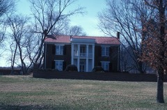
One of 135 National Register listings published here for Williamson County · listed in 1988 · category: Building.
Sources: the National Register database, National Park Service · the Wikipedia article

Listed on the National Register of Historic Places in 1988.
One of 135 National Register listings published here for Williamson County · listed in 1988 · category: Building.
Sources: the National Register database, National Park Service · the Wikipedia article
Regional context, not property-specific evidence. The federal mineral resources record lists 43 workings within 5 miles of Douglass-Reams House: 18 past producers, 11 unknowns, 10 producers, 2 prospects. 10 still produce. What was taken out: Phosphorus-Phosphates, Stone, Crushed/Broken, Stone, Crushed/Broken, Limestone, General, Aluminum. Distance is straight-line from the map coordinates, so a quarry counted here may appear on a neighbouring settlement's page as well.
| Where | Site | Commodity | Status | Recorded |
|---|---|---|---|---|
| Tillman No 113 | Aluminum, Phosphorus-Phosphates | Past Producer | ||
| Franklin Plant | Stone, Crushed/Broken, Limestone, General | Producer | Limestone | |
| Williamson County Highway Department Quarry | Stone, Crushed/Broken, Limestone, General | Producer | Limestone | |
| Franklin Pit & Plant | Stone, Crushed/Broken | Past Producer | ||
| Franklin Quarry | Stone, Crushed/Broken | Producer | ||
| Globe Quarry | Stone, Crushed/Broken | Producer | ||
| Battlefield Hood #862 | Phosphorus-Phosphates | Occurrence | ||
| Battlefield No.862 Prospect | Phosphorus-Phosphates | Occurrence | ||
| Battlefield Number 1062 Pit | Phosphorus-Phosphates | Past Producer | ||
| Battlefield Pit | Phosphorus-Phosphates | Producer |
Regional context, not property-specific evidence. The National Weather Service names Franklin, the town this property stands in, in 115 storm reports between 1993 and 2026: 57 thunderstorm wind, 39 hail, 9 flash flood, 5 lightning. The reports record 1 death and 7 injuries. Each account below is quoted exactly as the forecast office filed it, from the NOAA Storm Events Database, and each date opens the federal record of that event.
| When | Event | Place named | Harm | What the report says |
|---|---|---|---|---|
| June 2003 | Thunderstorm Wind | Franklin | 1 killed | A large tree fell on a minivan during a severe thunderstorm. It killed a 58 year-old woman who was driving southbound on Liberty Church Road. |
| April 2012 | Tornado (EF0) | Franklin | 6 hurt, $75,000 | An NWS Storm Survey confirmed an EF0 tornado touched down in Franklin. Damage began near the intersection of Highway 96 and Founders Point Boulevard where several trees were snapped and minor roof damage occurred. Continuous damage was noted heading to the south-southeast through Jim Warren Park where several vehicles were flipped over causing 6 minor injuries. The tornado continued across a mobile home park along Highway 246 where trees fell onto three mobile homes causing major damage. Numerous other homes in the area suffered shingle, siding, and gutter damage and dozens of other trees were snapped and uprooted. The damage path then turned more to the southeast, moving over a quarry and crossing Highway 31 just north of Highway 397. Damage in this part of the path was confined to snapped trees and tree limbs along with some minor roof damage. The last evidence of damage was between Bluebell Way and Wynbrook Court where several softwood trees were snapped, a fence was blown down, and a patio covering was flipped. |
| May 2003 | Tornado (F3) | Franklin | 1 hurt, $2,200,000 | 43 homes were damaged and 3 homes were destroyed in Williamson County by the tornado. 28 units in the Executive House condominium complex in Franklin had to be evacuated after the roof was torn away. Crews worked Sunday to free people trapped inside their homes by fallen trees on Big East Fork Rd. Most of the damage to homes was roof damage and trees falling on houses.An 84-year-old grandmother was rescued from a demolished 3-story home at 1933 Old Hillsoboro Rd. She received a fractured pelvic bone. |
| May 2003 | Tornado (F1) | Franklin | $3,000,000 | 85 homes were damaged, 2 barns were destroyed and 5 businesses were damaged. |
| May 2003 | Lightning | Franklin | $141,000 | Lightning struck and burned down a home. The house was completely destroyed on Shady Glen Ct., near Franklin. |
| May 2000 | Flash Flood | Franklin | $100,000 | The flood waters were up to windows in an elementary school near Highway 96 and Nolensville Rd. 38 people at an assisted living center were evacuated. The living center received considerable water damage. |
| June 1998 | Flash Flood | Franklin | $50,000 | News article reported 30 homes sustained water damage from flash flooding in Brentwood. |
| June 1999 | Lightning | Franklin | $30,000 | Lightning struck a subsation on Eddy Lane. The lightning damaged a breaker, insulators, and lightning arrestors. 8000 customers were without power. |
| June 1998 | Lightning | Franklin | $30,000 | News article states that lightning struck a home on 1221 Temple Ridge Dr. and started a fire on the roof. The fire on the roof then spread to the attic and walls of the house. |
| January 2013 | Thunderstorm Wind | Franklin | $25,000 | Numerous trees and power lines were blown down all across Williamson County with several trees falling on homes in Franklin. |
| May 2001 | Thunderstorm Wind | Franklin | $25,000 | Trained spotter reported trees down across Maryland Farms Rd. Also, 4 homes were damaged in Spring Hill when trees fell on them. A two story house on Halifax Road received the most damage when a 200 year old tree fell on top of the middle of the house. The tree had been weakened by insect and wildlife damage according to workers at the scene. |
| April 2026 | Thunderstorm Wind | Franklin | $10,000 | Severe thunderstorm winds downed multiple trees in the Franklin area. Damages are a rough estimate. |
| June 2019 | Thunderstorm Wind | Franklin | $10,000 | Trees were blown down across Williamson County, with Franklin and Fairview the hardest hit areas. |
| May 2013 | Thunderstorm Wind | Franklin | $10,000 | A Twitter report was received reporting trees and powerlines down along a few roads in Franklin. |
| May 2004 | Lightning | Franklin | $10,000 | Lightning struck a 2-story brick home on Jones Parkway, just off Concord Rd. It caused a fire in the attic and to the roof, but there was no fire damage to the living space. |
| March 1997 | Thunderstorm Wind | Franklin | $10,000 | Local law enforcement reported a home damaged and a tree blown down. |
| June 1995 | Thunderstorm Wind | Franklin | $10,000 | Several trees and power lines were knocked down. |
| July 2019 | Thunderstorm Wind | Franklin | $5,000 | Several Twitter reports and photos showed scattered trees were blown down across Franklin, with one tree falling onto a vehicle. |
| October 2007 | Thunderstorm Wind | Franklin | $5,000 | Trees were blown down. A large tree limb fell on a house on High Point Ridge Rd. |
| May 1995 | Thunderstorm Wind | Franklin | $5,000 | A few trees were blown on top of some power lines. |
| March 2017 | Thunderstorm Wind | Franklin | $2,000 | A tree was blown down at 1204 Twin Oaks Drive in Franklin. |
| September 2016 | Thunderstorm Wind | Franklin | $2,000 | A Twitter report indicated a tree and a power line were blown down on Del Rio Pike. |
| February 2014 | Thunderstorm Wind | Franklin | $2,000 | Two trees were blown down blocking Del Rio Pike in Franklin. |
| June 1995 | Thunderstorm Wind | Franklin | $2,000 | Several trees were blown down. |
| June 2024 | Thunderstorm Wind | Franklin | $1,000 | A tSpotter reported a snapped tree limb near downtown Franklin. Damages are a rough estimate. |
| March 2022 | Thunderstorm Wind | Franklin | $1,000 | A tSpotter report and photo showed a tree snapped in the Founders Pointe neighborhood. |
| September 2020 | Thunderstorm Wind | Franklin | $1,000 | A Twitter tSpotter report indicated a tree was blown down in Blossom Park. |
| February 2017 | Thunderstorm Wind | Franklin | $1,000 | A tree was blown down in Franklin. |
| March 2017 | Thunderstorm Wind | Franklin | $1,000 | A tSpotter Twitter report indicated a tree was blown down in the Franklin Green subdivision. |
| June 2016 | Thunderstorm Wind | Franklin | $1,000 | A house reportedly had roof damage in Franklin. |
| July 2015 | Thunderstorm Wind | Franklin | $1,000 | A tree was blown down over Carters Creek Pike at Horton Lane with the roadway not passable and closed. |
| November 2004 | Flash Flood | Franklin | $1,000 | Flooding was occurring near the Franklin area at Southall Road and Old Hillsboro Road...just west of Franklin. Flooding was occurring on Del Rio Pike. |
| June 1999 | Lightning | Franklin | $1,000 | Lightning struck a gable to a home at Fieldstone Farms. |
| November 1998 | Thunderstorm Wind | Franklin | $500 | Trees and power lines were down. A falling tree went through a car's windshield. |
| August 1993 | Thunderstorm Wind | Franklin | $500 | Numerous trees were knocked down. |
| April 2007 | Thunderstorm Wind | Franklin | $100 | A tree was down on Hillsboro Road and Waddell Hollow Rd. |
| May 1995 | Hail | Franklin | $100 | A few trees were blown on top of some power lines. |
| March 2025 | Hail | Franklin | - | Estimated 1 inch hail was reported from a severe thunderstorm near Franklin. |
| March 2025 | Hail | Franklin | - | Estimated half dollar size hail was reported from a severe thunderstorm in Franklin. |
| May 2025 | Hail | Franklin | - | Estimated baseball size hail was reported near Franklin. |
| April 2025 | Hail | Franklin | - | Estimated half dollar size hail was reported near Franklin. |
| April 2025 | Hail | Franklin | - | Estimated half dollar size hail was reported near Franklin from a tornado-warned thunderstorm. |
| September 2024 | Hail | Franklin | - | Nickel size hail fell in the Cool Spring area. |
| May 2024 | Hail | Franklin | - | Golf ball size hail was reported near Franklin. |
| March 2021 | Hail | Franklin | - | Social media report of quarter size hail in Westhaven. |
| January 2008 | Heavy Rain | Franklin | - | A report of 1.80 inches of rain fell in a half hour period. A newspaper story stated that Williamson County schools released students 30 minutes later than usual, in order to allow the thunderstorms to pass. |
| April 2007 | Hail | Franklin | - | Law enforcement reported hail the size of golf balls. |
| April 2006 | Hail | Franklin | - | Golf to tennis ball size hail in Franklin near the intersection of Mack Hatcher Parkway and U.S. Highway 431. |
| April 2006 | Hail | Franklin | - | Quarter size hail along I-65 east of Franklin. |
| May 2006 | Hail | Franklin | - | Penny size hail reported on Church Street in Brentwood. |
| May 2006 | Thunderstorm Wind | Franklin | - | Trees blown down near the intersection of Highway 96 and Carothers Rd. |
| April 2006 | Hail | Franklin | - | Nickel size hail along Pinewood Road in western Williamson County. |
| February 2005 | Thunderstorm Wind | Franklin | - | Trees were blown down. |
| May 2005 | Thunderstorm Wind | Franklin | - | TDOT reported trees down just west of Franklin. |
| May 2005 | Thunderstorm Wind | Franklin | - | Spotter reported trees down on Cool Springs Road and Mallory Lane near Cool Springs Mall. |
| June 2005 | Thunderstorm Wind | Franklin | - | Large tree branch fell on a car near the intersection of Mack Hatcher Parkway and Cool Springs Blvd. |
| August 2005 | Thunderstorm Wind | Franklin | - | Sheriff's office reported a tree was down. |
| June 2004 | Hail | Franklin | - | Quarter size hail observed. |
| July 2004 | Thunderstorm Wind | Franklin | - | Several large trees down in the Concord Road area of Brentwood. |
| July 2004 | Thunderstorm Wind | Franklin | - | Trees and power lines were down around the city. |
No historic map-sheet match is published for this property yet. That does not mean no map exists. This record needs a coordinate-quality review before it can be joined to a sheet boundary. Browse the county's mapped places while that work is pending.
Other National Register properties close enough to walk or drive between, ordered by distance from this one. Both positions come from the same geocoding pass that matched these properties to their map sheets.
| Photograph | Property | Distance | Listed |
|---|---|---|---|
| Mordecai Puryear House | 0.4 miles | 1988 | |
 | Dr. Hezekiah Oden House | 0.6 miles | 1988 |
 | Robert Hodge House | 1.1 miles | 2005 |
 | Rainey House | 1.4 miles | 1970 |
 | Harrison House | 1.8 miles | 1975 |
 | McGavock-Gaines House | 1.9 miles | 1988 |
| National Archives record | The nomination case file for reference 88000293 in Record Group 79. |
| Wikipedia article | Community-written account of this property, licensed CC BY-SA. |
| Williamson County | All 135 listed properties in this county. |