 Block
From the record
One of 35 National Register listings published here for Giles County · listed in 1988 · category: Building.
Sources: the National Register database, National Park Service · the Wikipedia article
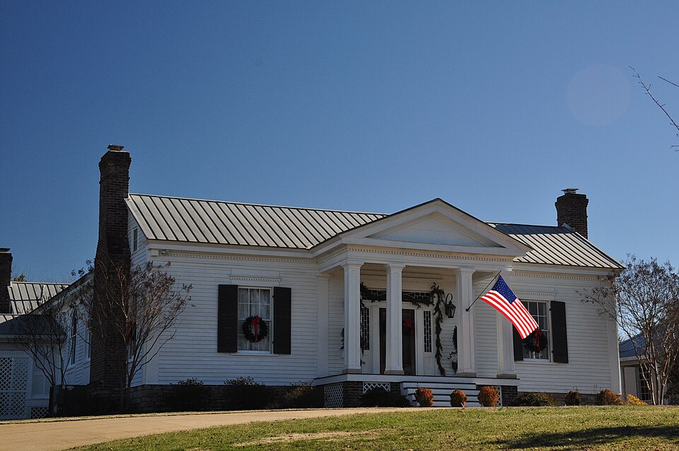
Listed on the National Register of Historic Places in 1988.
One of 35 National Register listings published here for Giles County · listed in 1988 · category: Building.
Sources: the National Register database, National Park Service · the Wikipedia article
Regional context, not property-specific evidence. The federal wildfire occurrence database lists 71 fires within 5 miles of Copeland Whitfield House between 1998 and 2019, burning about 136 acres in total. None started naturally. 8 were recorded as arson. Distance is straight-line from the map coordinates, so a fire counted here may appear on a neighbouring settlement's page as well.
| Reported cause | Fires |
|---|---|
| Debris and open burning | 50 |
| Arson/incendiarism | 8 |
| Missing data/not specified/undetermined | 7 |
| Equipment and vehicle use | 3 |
| Other causes | 2 |
| Misuse of fire by a minor | 1 |
The most recent of them, most recent first, with the day each was reported and the service that recorded it.
| Date | Cause | Size | Reported by | Name on the report |
|---|---|---|---|---|
| 23 September 2008 | Debris and open burning | under an acre | Tennessee Division of Forestry | not named |
| 18 September 2010 | Arson/incendiarism | 5.0 acres | Tennessee Division of Forestry | CATAWBA |
| 9 August 1999 | Debris and open burning | 5.0 acres | Tennessee Division of Forestry | not named |
| 7 August 1999 | Debris and open burning | under an acre | Tennessee Division of Forestry | not named |
| 29 August 2000 | Debris and open burning | 2.0 acres | Tennessee Division of Forestry | not named |
| 29 August 2000 | Debris and open burning | under an acre | Tennessee Division of Forestry | not named |
| 23 August 2006 | Debris and open burning | under an acre | Tennessee Division of Forestry | not named |
| 18 August 2000 | Debris and open burning | under an acre | Tennessee Division of Forestry | not named |
Regional context, not property-specific evidence. The federal mineral resources record lists 9 workings within 5 miles of Copeland Whitfield House: 5 unknowns, 3 producers, 1 past producer. 3 still produce. What was taken out: Phosphorus-Phosphates, Stone, Crushed/Broken. Distance is straight-line from the map coordinates, so a quarry counted here may appear on a neighbouring settlement's page as well.
| Where | Site | Commodity | Status | Recorded |
|---|---|---|---|---|
| Cedar Grove Limestone Co. Quarry | Stone, Crushed/Broken | Producer | Limestone | |
| Giles County Materials | Stone, Crushed/Broken | Producer | ||
| Buford Mine-Pulaski | Phosphorus-Phosphates | Past Producer | ||
| Mobil Phosphate Deposit No.20 | Phosphorus-Phosphates | Unknown | ||
| Mobil Phosphate Deposit No.21 | Phosphorus-Phosphates | Unknown | ||
| Monsanto Phosphate No.27 | Phosphorus-Phosphates | Unknown | ||
| Prospect Mine | Phosphorus-Phosphates | Producer | ||
| Stauffer Phosphate Deposit No.11 | Phosphorus-Phosphates | Unknown | ||
| Stauffer Phosphate Deposit No.12 | Phosphorus-Phosphates | Unknown |
Regional context, not property-specific evidence. The National Weather Service names Pulaski, the town this property stands in, in 98 storm reports between 1993 and 2026: 64 thunderstorm wind, 16 hail, 9 flash flood, 5 lightning. No death or injury is recorded in these reports. Each account below is quoted exactly as the forecast office filed it, from the NOAA Storm Events Database, and each date opens the federal record of that event.
| When | Event | Place named | Harm | What the report says |
|---|---|---|---|---|
| July 1999 | Lightning | Pulaski | $150,000 | Four mobile homes were struck by lightning. These homes were fully loaded when they were struck at the Oakwood Homes on Highway 31. |
| May 2020 | Thunderstorm Wind | Pulaski | $113,220 | Numerous trees and power lines were blown down across Giles County. |
| March 1997 | Flash Flood | Pulaski | $100,000 | 8 roads closed due to high water. Several roads were damaged. Hardest hit area was northwest to northeast of Pulaski. |
| May 2024 | Thunderstorm Wind | Pulaski | $50,000 | A NWS storm survey team found straight line wind damage in Giles County, particularly around the Pulaski area. Numerous trees were snapped and uprooted in a northwest to southeast direction. Some of the worst damage was found on Cherry Drive and Richland Street where some trees fell onto homes. Winds were estimated up to 75 mph. Damages are a rough estimate. |
| May 2006 | Lightning | Pulaski | $50,000 | The downtown studios of WKSR-AM and WKSR-FM were struck by lightning on South Second St. in Pulaski. The lightning knocked out the phone system and the inner office network. The inner office network allows the on-air computers to talk to each other, including the EAS computer system at the station. The station's satellite system, Internet service, the Associated Press link to the radio station, an office computer, and a modem in another computer were completely destroyed. |
| May 1994 | Thunderstorm Wind | Pulaski | $50,000 | A few trees were knocked down. One tree smashed into a mobile home producing considerable damage to the home. |
| June 2005 | Thunderstorm Wind | Pulaski | $40,000 | EMA Director reported a tin roof was peeled off a Department of Highway Building by a strong thunderstorm wind gust. |
| April 2011 | Thunderstorm Wind | Pulaski | $30,000 | Numerous trees and power lines were downed across the county. One report was received of a church sustaining damage. Specific details concerning the exact location|of the church, the amount and type of damage that occurred along with the associated cost, were unknown. |
| August 2011 | Thunderstorm Wind | Pulaski | $20,000 | Approximately 100 trees were blown down across Giles County. |
| August 2005 | Lightning | Pulaski | $20,000 | Lightning struck a home at 200 Harmon Dr. The lightning set fire in the attic and burned the rafters. The fire was under control in 10 to 15 minutes by the Pulaski Fire Department. |
| February 2009 | Thunderstorm Wind | Pulaski | $12,000 | Trees were blown down across the area. |
| July 2005 | Lightning | Pulaski | $12,000 | News article stated that a home located at 2202 Cherry Drive was struck by lightning in the Westview subdivision. The lightning welded the gutters to the house, blew out the phones and cable television lines, and scorched the homes in several spots. Officials with the Pulaski Fire Department estimated the damage to be at about $12,000. |
| July 2023 | Thunderstorm Wind | Pulaski | $10,000 | A Facebook user reported numerous trees down across Giles County with a shed overturned in Pulaski. Damages are a rough estimate. |
| February 2014 | Thunderstorm Wind | Pulaski | $10,000 | Trees and power lines were blown down in several parts of Giles County. |
| June 2014 | Thunderstorm Wind | Pulaski | $10,000 | Numerous trees were blown down all across Giles County. |
| April 2011 | Thunderstorm Wind | Pulaski | $10,000 | Several trees were blown down on U.S. Highway 31 near Pulaski. |
| April 2011 | Thunderstorm Wind | Pulaski | $10,000 | Spotters reported large trees were downed and two power poles were snapped. |
| September 2009 | Flash Flood | Pulaski | $10,000 | Several roads were flooded in and around Pulaski. |
| January 1999 | Hail | Pulaski | $10,000 | Softball size hail damaged numerous vehicles. |
| June 2021 | Thunderstorm Wind | Pulaski | $8,000 | Numerous trees and power lines were blown down along Highway 64 just northwest of Pulaski, including some trees over 2 feet in diameter. Several sheet metal roofs were also damaged. |
| March 2026 | Thunderstorm Wind | Pulaski | $5,000 | Severe thunderstorm winds peeled up a local business's metal roof in Pulaski. Damages are a rough estimate. |
| June 2019 | Thunderstorm Wind | Pulaski | $5,000 | A tree was blown down near the intersection of West Madison Street and N. 8th Street in Pulaski and caused minor roof damage to a home. |
| June 2019 | Thunderstorm Wind | Pulaski | $5,000 | Trees were blown down across Giles County. |
| December 2019 | Thunderstorm Wind | Pulaski | $5,000 | Several reports of trees down across Giles County. |
| August 2017 | Flash Flood | Pulaski | $5,000 | Several roads were flooded and closed in and south of Pulaski including Braly Lane at Bennett Drive, as well as Garner Hollow Road where a water rescue was conducted. |
| July 2016 | Thunderstorm Wind | Pulaski | $5,000 | Giles County Emergency Manager reported a microburst struck Pulaski from the industrial area on the northwest side of town into downtown. Photos showed 4 utility poles were snapped on Industrial Blvd and Bennet Drive. Several trees were also blown down, including one tree falling on a car at 5th Street and Flower Street, and another tree down on East Madison Street. Winds were estimated around 60 mph. |
| December 2013 | Thunderstorm Wind | Pulaski | $5,000 | Scattered trees were blown down across Giles County. |
| June 2011 | Thunderstorm Wind | Pulaski | $5,000 | Several trees were blown down south of Pulaski and large oak trees were stripped of leaves. |
| October 2011 | Thunderstorm Wind | Pulaski | $5,000 | Trees were reportedly blown down on the north side of Pulaski with power outages in the area. |
| June 2010 | Thunderstorm Wind | Pulaski | $5,000 | A tree was blown down and blocked a road. Specific location of that road was not given. |
| April 1998 | Thunderstorm Wind | Pulaski | $5,000 | 2 new air conditoning units were blown off the roof of the Giles County Courthouse. |
| June 1995 | Thunderstorm Wind | Pulaski | $5,000 | Several trees and power lines were knocked down. |
| May 2020 | Thunderstorm Wind | Pulaski | $3,000 | Several power lines were blown down in Pulaski. |
| July 2018 | Thunderstorm Wind | Pulaski | $3,000 | Trees were blown down on East Jefferson Street. |
| June 2018 | Thunderstorm Wind | Pulaski | $3,000 | Several trees were blown down in Pulaski. |
| June 2016 | Thunderstorm Wind | Pulaski | $3,000 | A few trees down throughout Giles County. |
| October 2004 | Thunderstorm Wind | Pulaski | $3,000 | Roof blown off a house on Lexington Highway |
| June 2021 | Thunderstorm Wind | Pulaski | $2,000 | A few trees down and minor metal roofing damage in Pulaski. |
| June 2011 | Thunderstorm Wind | Pulaski | $2,000 | Trees were blown down with small hail reported in and around Pulaski. |
| June 2016 | Thunderstorm Wind | Pulaski | $1,000 | Trees were blown down with power outages. A 60 mph wind gust was measured. |
| October 2014 | Thunderstorm Wind | Pulaski | $1,000 | A tree was snapped in Pulaski. |
| August 2012 | Thunderstorm Wind | Pulaski | $1,000 | A tree was blown down in Pulaski. |
| March 2012 | Flash Flood | Pulaski | $1,000 | Some streets were covered with water in Pulaski. |
| May 2006 | Flash Flood | Pulaski | $1,000 | Water over several roads including Highway 31. |
| March 2004 | Thunderstorm Wind | Pulaski | $1,000 | Trees were blown down. A gazebo was blown away on U.S. Highway 64 west. |
| July 2008 | Thunderstorm Wind | Pulaski | $500 | Sheriff's office reported trees were down along Highway 166. |
| August 1993 | Thunderstorm Wind | Pulaski | $500 | Some trees were blown down. |
| August 1993 | Thunderstorm Wind | Pulaski | $500 | A few power lines were blown down. |
| July 2008 | Thunderstorm Wind | Pulaski | $100 | A tree was down on Weakley Rd. |
| July 2008 | Thunderstorm Wind | Pulaski | $100 | A tree was down on Access Rd. |
| September 1995 | Thunderstorm Wind | Pulaski | $100 | Few trees and power lines were down. Report was by local electric company. |
| May 2025 | Flash Flood | Pulaski | - | Heavy rain caused flash flooding along College Street in Pulaski. Extent of damages is unknown. |
| July 2017 | Heavy Rain | Pulaski | - | The Pulaski COOP Observer measured a total rainfall of 4.24 inches for July 28. |
| April 2016 | Heavy Rain | Pulaski | - | A COOP observer in Pulaski measured a 24-hour rainfall total of 3.53 inches. |
| April 2012 | Hail | Pulaski | - | Public report via Facebook. |
| April 2011 | Funnel Cloud | Pulaski | - | Two funnel clouds were reported in this area. |
| April 2009 | Hail | Pulaski | - | Quarter size hail was reported in Pulaski. |
| September 2009 | Heavy Rain | Pulaski | - | Law Enforcement reported water standing on main roadway through the city of Pulaski. CoCoRaHS reports from near the city of Pulaski showed up to 3 inches of rainfall in this vicinity. |
| March 2006 | Thunderstorm Wind | Pulaski | - | One tree down on Annie Wade Rd. |
| March 2006 | Thunderstorm Wind | Pulaski | - | One tree was down on Shady Lane Rd. |
No historic map-sheet match is published for this property yet. That does not mean no map exists. This record needs a coordinate-quality review before it can be joined to a sheet boundary. Browse the county's mapped places while that work is pending.
Other National Register properties close enough to walk or drive between, ordered by distance from this one. Both positions come from the same geocoding pass that matched these properties to their map sheets.
| Photograph | Property | Distance | Listed |
|---|---|---|---|
 | Maplewood Cemetery | 1.6 miles | 2005 |
| Sam Davis Avenue Historic District | 1.8 miles | 1989 | |
| South Pulaski Historic District | 1.8 miles | 1986 | |
 | First Presbyterian Church of Pulaski | 2.0 miles | 1983 |
| Pulaski Courthouse Square Historic District (Boundary Increase) | 2.0 miles | 1997 | |
| Pulaski Courthouse Square Historic District | 2.1 miles | 1983 |
| National Archives record | The nomination case file for reference 88001021 in Record Group 79. |
| Wikipedia article | Community-written account of this property, licensed CC BY-SA. |
| Giles County | All 35 listed properties in this county. |