BlockBefore
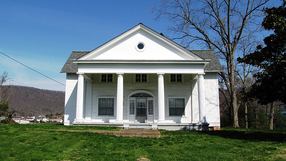
Photograph of A.E. Perkins House
Photograph by Brian Stansberry, CC BY 3.0. Via Wikimedia Commons.

A.E. Perkins House

Listed on the National Register of Historic Places in 1997.

From the record

“Perkins House is a historic house in Jacksboro, Tennessee, U.S.. The house was built circa 1850 for James Williams and his wife, Rebecca.”

Wikipedia article A.E. Perkins House, CC BY-SA 4.0.

One of 7 National Register listings published here for Campbell County · listed in 1997 · category: Building.

Sources: the Wikipedia article · the National Register database, National Park Service

The listing

  • What is counted as historic. The nomination lists 2 buildingss, 1 structure as contributing to the listing.
  • Listed as. Perkins, A.E., House - the National Register files a house under its owner's surname.
  • Address. 130 Valley St., Jacksboro, 37757
  • When was it listed? December 1997
  • Category. building
  • District. District 4
  • Architectural style. Colonial Revival architecture
  • National Register reference number. 97001529 - assigned by the National Park Service when the property was listed.

Fires near this property

114 since 1997

Regional context, not property-specific evidence. The federal wildfire occurrence database lists 114 fires within 5 miles of A.E. Perkins House between 1997 and 2020, burning about 4,777 acres in total. None started naturally. 55 were recorded as arson. Distance is straight-line from the map coordinates, so a fire counted here may appear on a neighbouring settlement's page as well.

Reported cause Fires
Arson/incendiarism55
Debris and open burning34
Missing data/not specified/undetermined18
Equipment and vehicle use2
Power generation/transmission/distribution2
Recreation and ceremony2
Railroad operations and maintenance1

The most recent of them, most recent first, with the day each was reported and the service that recorded it.

DateCause SizeReported by Name on the report
7 September 2007Missing data/not specified/undeterminedunder an acreTennessee Division of ForestryMETH LAB
22 September 1997Arson/incendiarismunder an acreTennessee Division of Forestrynot named
19 August 2007Arson/incendiarism15 acresTennessee Division of ForestryEAGLE BLUFF
16 August 1999Debris and open burningunder an acreTennessee Division of Forestrynot named
8 June 2008Missing data/not specified/undetermined7.0 acresTennessee Division of Forestrynot named
22 June 2008Missing data/not specified/undetermined75 acresTennessee Division of Forestrynot named
7 May 2018Missing data/not specified/undetermined1.0 acresTennessee Division of ForestryWILSON RD
6 May 2014Equipment and vehicle useunder an acreTennessee Division of ForestryI-75 MM 136

Every fire recorded in Campbell County

Mines and quarries near this property

7 within 5 miles

Regional context, not property-specific evidence. The federal mineral resources record lists 7 workings within 5 miles of A.E. Perkins House: 6 producers, 1 plant. All of them still produce. What was taken out: Silica, Stone, Crushed/Broken, Limestone, General, Stone, Crushed/Broken, Silica, Sand and Gravel, Construction. Distance is straight-line from the map coordinates, so a quarry counted here may appear on a neighbouring settlement's page as well.

Where SiteCommodity StatusRecorded
White Silica Sand Company PitSilica, Sand and Gravel, ConstructionProducer
Campbell County Highway Dept. QuarryStone, Crushed/Broken, Limestone, GeneralProducerLimestone
Campbell County QuarryStone, Crushed/BrokenProducer
Carborundum Co/ Jacksboro, Tn.SilicaPlant
Key Limestone Division Pit No. 27Stone, Crushed/BrokenProducer
Key Limestone Divisionpit #27Stone, Crushed/Broken, Limestone, GeneralProducerLimestone
White Silica Sand Co. PitSilicaProducer1929

Every working recorded in Campbell County

Storms near this property

25 since 1995

Regional context, not property-specific evidence. The National Weather Service names Jacksboro, the town this property stands in, in 25 storm reports between 1995 and 2023: 18 thunderstorm wind, 5 hail, 2 flood. No death or injury is recorded in these reports. Each account below is quoted exactly as the forecast office filed it, from the NOAA Storm Events Database, and each date opens the federal record of that event.

WhenEvent Place namedHarm What the report says
March 2006Thunderstorm WindJacksboro$20,000no account filed
May 2003Thunderstorm WindJacksboro$15,000no account filed
February 2008Thunderstorm WindJacksboro$10,000The Campbell County highway department reported several trees down countywide.
May 2002Thunderstorm WindJacksboro$10,000no account filed
April 2006Thunderstorm WindJacksboro$8,000A few trees down near Jacksboro.
June 2009Thunderstorm WindJacksboro$3,000Law enforcement officials reported two trees downed by thunderstorm winds near Jacksboro.
March 2009Thunderstorm WindJacksboro$3,000A few trees were reported down in Jacksboro.
June 2008Thunderstorm WindJacksboro$3,000Dispatch reported 2 trees downed by thunderstorm winds in Jacksboro.
February 2012Thunderstorm WindJacksboro$2,000Law enforcement personnel reported one tree downed by thunderstorm wind on Pine Crest Road near Jacksboro.
October 2009Thunderstorm WindJacksboro$2,000Law enforcement officials reported one tree downed by thunderstorm winds near Jacksboro.
February 2008Thunderstorm WindJacksboro$2,000Dispatch reported one tree down in Jacksboro.
May 1995Thunderstorm WindJacksboro$2,000A few trees were blown down.
July 2004Thunderstorm WindJacksboro$2,000no account filed
May 1995Thunderstorm WindJacksboro$1A roof was blown off of a barn. Several trees and power lines were blown down as well.
August 2023Thunderstorm WindJacksboro-Multiple trees were blown down by severe thunderstorm wind gusts.
January 2020Thunderstorm WindJacksboro-A few trees were reported down.
May 2016Thunderstorm WindJacksboro-Two trees were reported down.
June 2011HailJacksboro-A trained spotter reported thunderstorms produced quarter-size hail in Jacksboro.
September 2009FloodJacksboro-Heavy rainfall resulted in areal flooding from Jacksboro to La Follette, Tennessee. Several area roads had several inches to nearly a foot of water over the roads in this vicinity.
July 2005HailJacksboro-no account filed
December 2005HailJacksboro-no account filed
April 2003HailJacksboro-no account filed
November 2002HailJacksboro-no account filed
June 2000Thunderstorm WindJacksboro-no account filed
April 1998FloodJacksboro-no account filed

Every storm recorded in Campbell County

Map coverage status

No historic map-sheet match is published for this property yet. That does not mean no map exists. This record needs a coordinate-quality review before it can be joined to a sheet boundary. Browse the county's mapped places while that work is pending.

Listed places nearby

2 within 8 miles

Other National Register properties close enough to walk or drive between, ordered by distance from this one. Both positions come from the same geocoding pass that matched these properties to their map sheets.

Photograph PropertyDistance Listed
LaFollette House5.0 miles1975
LaFollette Coke Ovens5.2 miles2016

Sources for this property

National Archives recordThe nomination case file for reference 97001529 in Record Group 79.
Wikipedia articleCommunity-written account of this property, licensed CC BY-SA.
Campbell CountyAll 7 listed properties in this county.

Provenance

  • Listing record. National Park Service National Register of Historic Places, listed-properties dataset, current to 2026-05-22.
  • Map join. Address geocoded through the United States Census geocoder, then tested against the published boundary of every sheet in the USGS Historical Topographic Map Collection.
  • How this page is made. Listing fields come from federal records; map-sheet coverage is a labelled coordinate-to-boundary calculation, not a source-field claim.
  • Wildfire. Short, Karen C. 2022. Spatial wildfire occurrence data for the United States, 1992-2020 [FPA_FOD_20221014]. 6th Edition. Fort Collins, CO: Forest Service Research Data Archive. https://doi.org/10.2737/RDS-2013-0009.6 Collected with United States Government funding and usable without additional permissions or fees.
  • Mines and quarries. USGS Mineral Resources Data System (MRDS) https://mrdata.usgs.gov/mrds/ A work of the United States government, no copyright under 17 U.S.C. 105.
  • Storms. NOAA National Centers for Environmental Information, Storm Events Database https://www.ncei.noaa.gov/stormevents/ A work of the United States government, no copyright under 17 U.S.C. 105. Narratives are quoted verbatim from the National Weather Service report and are not edited or summarised.