 Block
BlockFrom the record
One of 57 National Register listings published here for Hays County · listed in 2002 · category: Structure.
Sources: the case file at the National Archives · the National Register database, National Park Service

Listed on the National Register of Historic Places in 2002.
One of 57 National Register listings published here for Hays County · listed in 2002 · category: Structure.
Sources: the case file at the National Archives · the National Register database, National Park Service
Regional context, not property-specific evidence. The federal wildfire occurrence database lists 69 fires within 5 miles of Bunton Branch Bridge between 2005 and 2020, burning about 482 acres in total. None started naturally. 2 were recorded as arson. Distance is straight-line from the map coordinates, so a fire counted here may appear on a neighbouring settlement's page as well.
| Reported cause | Fires |
|---|---|
| Missing data/not specified/undetermined | 34 |
| Debris and open burning | 19 |
| Equipment and vehicle use | 8 |
| Power generation/transmission/distribution | 3 |
| Recreation and ceremony | 2 |
| Arson/incendiarism | 2 |
| Smoking | 1 |
The most recent of them, most recent first, with the day each was reported and the service that recorded it.
| Date | Cause | Size | Reported by | Name on the report |
|---|---|---|---|---|
| 9 September 2017 | Debris and open burning | under an acre | Texas A & M Forest Service | GROOS FIRE |
| 6 August 2017 | Missing data/not specified/undetermined | under an acre | Texas A & M Forest Service | GRASS FIRE |
| 31 August 2019 | Missing data/not specified/undetermined | under an acre | Texas A & M Forest Service | KYLE CROSSING |
| 22 August 2019 | Missing data/not specified/undetermined | under an acre | Texas A & M Forest Service | IH 35 |
| 18 August 2019 | Missing data/not specified/undetermined | under an acre | Texas A & M Forest Service | IH 35 |
| 7 July 2020 | Missing data/not specified/undetermined | 1.0 acres | Texas A & M Forest Service | SANTA FE |
| 4 July 2019 | Missing data/not specified/undetermined | under an acre | Texas A & M Forest Service | DICKERSON |
| 3 July 2005 | Missing data/not specified/undetermined | 10 acres | Texas A & M Forest Service | not named |
Regional context, not property-specific evidence. The federal mineral resources record lists 5 workings within 5 miles of Bunton Branch Bridge: 5 producers. All of them still produce. What was taken out: Sand and Gravel, Construction, Limestone, General, Clay, Limestone, General, Stone, Crushed/Broken. Distance is straight-line from the map coordinates, so a quarry counted here may appear on a neighbouring settlement's page as well.
| Where | Site | Commodity | Status | Recorded |
|---|---|---|---|---|
| Texas Cement Quarry & Plant | Clay, Limestone, General, Stone, Crushed/Broken | Producer | ||
| Unnamed Quarry | Limestone, General | Producer | Limestone | |
| Howe Pit & Plant | Sand and Gravel, Construction | Producer | ||
| Howe Pits | Sand and Gravel, Construction | Producer | Gravel, Sand | |
| South Austin Pit | Sand and Gravel, Construction | Producer | Gravel, Sand |
Regional context, not property-specific evidence. The National Weather Service names Kyle, the town this property stands in, in 40 storm reports between 1996 and 2025: 13 flash flood, 12 hail, 9 thunderstorm wind, 3 tornado. The reports record 6 injuries. Each account below is quoted exactly as the forecast office filed it, from the NOAA Storm Events Database, and each date opens the federal record of that event.
| When | Event | Place named | Harm | What the report says |
|---|---|---|---|---|
| November 2001 | Tornado (F1) | Kyle | 3 hurt, $500,000 | This F1 tornado formed immediately after a previous F1 tornado that had been observed by a Department of Public Safety Trooper along I-35 between mile markers 215 and 217 from 2.5 miles north of Kyle to 5 miles northeast of Kyle. The two tornadoes continued together for several minutes, causing extensive tree damage along the frontage road with tops of trees sheared off. Large oak tree branches 5 to 8 inches round were twisted and scattered across the area. Numerous road signs bent over and twisted at the base along with uprooted trees. Some downed trees were pointing south, others were pointing north. The same held true with the bent over highway signs. Power line poles were snapped. They damaged the truck stop at exit #217 sustained extensive damage to the awnings and roof. Several 18-wheelers were knocked over the by tornadoes. A hotel under construction also was damaged along with a restaurant across I-35 from the GAS station. The Hays County Independent School District Headquarters building was also damaged. In all, over 100 homes were damaged by the tornadoes and two were destroyed. Almost 20 businesses suffered damage. Repair costs to area roads and bridges were estimated at near 1/2 million dollars. |
| November 2001 | Tornado (F1) | Kyle | 3 hurt, $500,000 | This first F1 tornado was observed by a Department of Public Safety Trooper as it formed some 2.5 miles north of Kyle. It moved across I-35 between mile markers 215 and 217 to 5 miles northeast of Kyle. The trooper also reported a second tornado that formed in the same vicinity as the first and moved alongside the first for several minutes. The two tornadoes caused extensive tree damage along the frontage road with tops of trees sheared off. Large oak tree branches 5 to 8 inches round were twisted and scattered across the area. Numerous road signs bent over and twisted at the base along with uprooted trees. Some downed trees were pointing south, others were pointing north. The same held true with the bent over highway signs. Power line poles were snapped. They damaged the truck stop at exit #217 sustained extensive damage to the awnings and roof. Several 18-wheelers were knocked over the by tornadoes. A hotel under construction also was damaged along with a restaurant across I-35 from the GAS station. The Hays County Independent School District Headquarters building was also damaged. In all, over 100 homes were damaged by the tornadoes and two were destroyed. Almost 20 businesses suffered damage. Repair costs to area roads and bridges were estimated at near 1/2 million dollars. |
| May 2015 | Flash Flood | Kyle | $100,000,000 | Thunderstorms produced heavy rain that caused flash flooding in Kyle and San Marcos. The majority of the flooding was along the Blanco and San Marcos Rivers. A massive floodwave came down the Blanco River from Wimberley. Huge amounts of debris came with the flood waters. Four people were trapped on a roof awaiting a helicopter rescue in Kyle. I-35 was closed in both directions in San Marcos when the Blanco River flooded and overtopped the interstate. Hwy 80 bridge was also overtopped with flood water just east of I-35. Highway 80 was closed with debris bumping into a bridge structure. Water flooded the Aspen Apartment complex and water was reported to be up to the top of car tires in the parking lot. The Hays County jail in San Marcos was evacuated due to flooding. Many homes along River Road were flooded as well as businesses along the I-35 frontage road as the San Marcos river started to backup into town. All along the Blanco River in Hays County 1515 structures were impacted with 321 houses destroyed and an additional 376 receiving Major damage according to assessments. It is estimated that there were 100 million dollars in insured losses for this flash flood. |
| January 2020 | Thunderstorm Wind | Kyle | $100,000 | A thunderstorm produced wind gusts estimated at 75 mph that blew the siding off a house and flipped over a storage pod in Kyle. There were multiple trees and fences blown down near this neighborhood as well as areas just to the west on the west side of Interstate 35. Multiple houses had shingle damage. |
| August 2017 | Flood | Kyle | $100,000 | Hurricane Harvey moved onshore as a Category 4 hurricane over San Jose Island east of Rockport during the late evening of August 25th. Harvey moved inland entering southern DeWitt County during the morning of August 26th as a Category 1 hurricane. It continued to weaken as it moved farther inland eventually reaching south central Gonzales County as a tropical storm during the late evening of August 26th. The center of the storm made a loop through Gonzales, Karnes, and DeWitt Counties before exiting our County Warning Area during the afternoon of August 27th moving into Victoria County. ||The eastern half of Hays County experienced tropical storm force winds with gusts as high as 50 mph during the storm. This produced some minor tree damage and knocked out power. 100 people were evacuated due to rising water on creeks and the threat of a small dam breach during the height of the event. A sinkhole developed on Highway 21 due to the heavy rain amounts. Across the county, rainfall totals averaged 8 to 12 inches along and east of Interstate 35. Monetary loss are estimates of road repair. |
| May 2010 | Lightning | Kyle | $100,000 | The Austin American Statesman reported that a house caught fire as a result of a lightning strike. The house was destroyed. |
| October 2000 | Thunderstorm Wind | Kyle | $15,000 | A downburst from a severe thunderstorm damaged trees, homes between Martindale and Kyle |
| June 2014 | Thunderstorm Wind | Kyle | $5,000 | A thunderstorm produced wind gusts estimated at 65 mph that blew down a wood privacy fence, a large Arizona Ash, a large Red Oak, and many six inch diameter tree branches. |
| May 1997 | Tornado (F1) | Kyle | $5,000 | A small tornado knocked over trees and power lines in the area just north and west of Kyle. |
| June 2019 | Thunderstorm Wind | Kyle | $1,000 | A thunderstorm produced wind gusts estimated at 60 mph that knocked down a large tree limb in Kyle. |
| August 2020 | Thunderstorm Wind | Kyle | $100 | A thunderstorm produced wind gusts estimated at 60 mph that knocked down a large tree limb at a house. |
| March 2025 | Hail | Kyle | - | A thunderstorm produced quarter size hail in Kyle. |
| March 2025 | Hail | Kyle | - | A thunderstorm produced quarter size hail in Kyle. |
| May 2025 | Hail | Kyle | - | A thunderstorm produced tennis ball size hail near Simon Middle School in Kyle. |
| October 2023 | Flash Flood | Kyle | - | Thunderstorms produced locally heavy rain that led to flash flooding. Several low water crossings were flooded south of Kyle including on Roland Ln. and Bunton Ln. |
| May 2021 | Hail | Kyle | - | A thunderstorm produced quarter size hail in Kyle. |
| May 2021 | Flash Flood | Kyle | - | Thunderstorms produced heavy rain that led to flash flooding. Several roads across Hays County were flooded. |
| April 2021 | Hail | Kyle | - | A thunderstorm produced quarter size hail between San Marcos and Kyle. |
| April 2020 | Flash Flood | Kyle | - | Thunderstorms produced heavy rain that led to flash flooding. There was several feet of water over the roadways on Cotton Gin Rd. and Bunton Ln. along Bunton Branch and Porter Creek on the east side of Kyle. |
| August 2020 | Thunderstorm Wind | Kyle | - | A thunderstorm produced wind gusts estimated at 60 mph by an NWS employee. |
| March 2018 | Flash Flood | Kyle | - | Thunderstorms produced heavy rain that led to flash flooding closing numerous roads in Kyle. |
| March 2018 | Flash Flood | Kyle | - | Thunderstorms produced heavy rain that led to flash flooding closing numerous low water crossings in the San Marcos and Kyle areas. |
| September 2018 | Flash Flood | Kyle | - | Thunderstorms produced heavy rain that led to flash flooding. Lehman Rd. south was flooded at Masonwood Dr. in Kyle. |
| April 2016 | Thunderstorm Wind | Kyle | - | A thunderstorm produced wind gusts estimated at 70 mph that knocked over a tractor trailer truck closing two lanes of northbound I-35 in San Marcos. |
| March 2016 | Thunderstorm Wind | Kyle | - | A thunderstorm produced wind gusts estimated at 60 mph that downed power lines in Kyle. |
| October 2015 | Flash Flood | Kyle | - | Thunderstorms produced heavy rain that caused flash flooding. A CoCoRaHS observer southwest of Kyle reported 7.36 inches of rain in an hour and that the bridge near their house appeared to have been washed away with the road floating. |
| October 2015 | Flash Flood | Kyle | - | Thunderstorms produced heavy rain that caused flash flooding sending creeks feeding into the Blanco River out of their banks southwest of Kyle. Tremendous rainfall totals in excess of 5-10 inches of rain fell across this area during the morning hours. |
| June 2014 | Thunderstorm Wind | Kyle | - | Thunderstorms produced wind gusts estimated at 60 mph that blew down numerous trees and power lines between Kyle, Buda, and Dripping Springs. |
| June 2010 | Flash Flood | Kyle | - | Thunderstorms produced heavy rain which caused flooding and closed several streets in Kyle. |
| June 2007 | Flash Flood | Kyle | - | Thunderstorms produced 2 to 3 inch rain totals from Kyle eastward to the Caldwell County line, with up to 4 inches just east of Kyle. FM150 and FM2001 were closed through the early afternoon due to high water. |
| January 2007 | Flash Flood | Kyle | - | Rainfall south of a line from Wimberley to Buda averaged between 2 and 3 inches, with between 5 and 7 inches in the San Marcos area. Widespread flash flooding closed FM12, FM150 and FM621,among many other rural roads and city streets through the morning period. This flood was a large factor in making recovery efforts from the wind and tornado damage even more difficult. |
| July 2007 | Flash Flood | Kyle | - | From 2 to 3 inches of rain fell in the early afternoon of July 25 causing flash flooding that closed FM150 and FM2001. |
| April 2016 | Hail | Kyle | - | no account filed |
| May 2014 | Hail | Kyle | - | no account filed |
| May 2014 | Hail | Kyle | - | no account filed |
| May 2014 | Hail | Kyle | - | no account filed |
| May 2014 | Hail | Kyle | - | no account filed |
| April 2007 | Hail | Kyle | - | no account filed |
| October 2002 | Hail | Kyle | - | no account filed |
| September 1996 | Funnel Cloud | Kyle | - | no account filed |
No historic map-sheet match is published for this property yet. That does not mean no map exists. This record needs a coordinate-quality review before it can be joined to a sheet boundary. Browse the county's mapped places while that work is pending.
Other National Register properties close enough to walk or drive between, ordered by distance from this one. Both positions come from the same geocoding pass that matched these properties to their map sheets.
| Photograph | Property | Distance | Listed |
|---|---|---|---|
 | Downtown Buda Historic District | 2.7 miles | 2003 |
 | Onion Creek Post Office and Stagecoach House | 3.3 miles | 2002 |
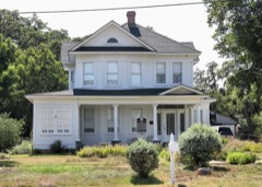 | Cora Jackman Donalson House | 4.3 miles | 2010 |
 | Kyle City Hall | 4.3 miles | 2002 |
 | Katherine Anne Porter House | 4.3 miles | 2004 |
 | M.G. Michaelis Ranch | 5.4 miles | 2003 |
| National Archives record | The nomination case file for reference 02000086 in Record Group 79. |
| Hays County | All 57 listed properties in this county. |