 Block
BlockFrom the record
One of 4 National Register listings published here for Cass County · listed in 2004 · category: Building.
Sources: the case file at the National Archives · the National Register database, National Park Service · the Wikipedia article
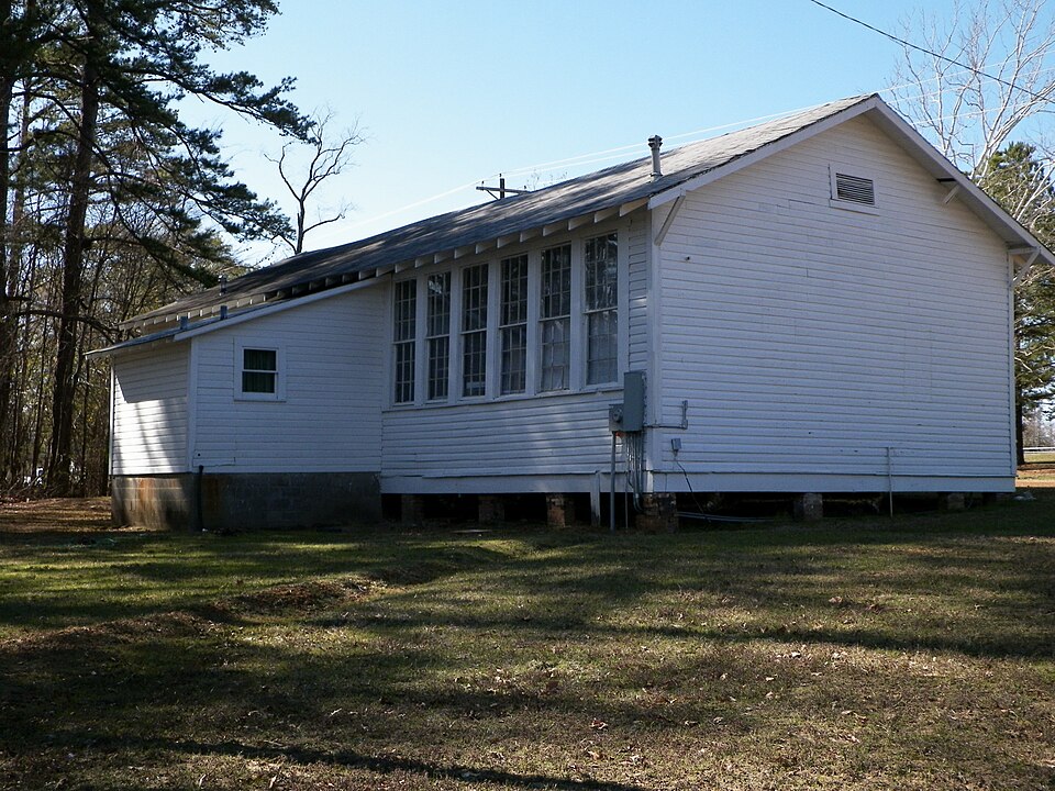
Listed on the National Register of Historic Places in 2004.
One of 4 National Register listings published here for Cass County · listed in 2004 · category: Building.
Sources: the case file at the National Archives · the National Register database, National Park Service · the Wikipedia article
Regional context, not property-specific evidence. The federal wildfire occurrence database lists 237 fires within 5 miles of Pleasant Hill School between 1992 and 2020, burning about 1,227 acres in total. 13 started naturally. 22 were recorded as arson. Distance is straight-line from the map coordinates, so a fire counted here may appear on a neighbouring settlement's page as well.
| Reported cause | Fires |
|---|---|
| Debris and open burning | 127 |
| Missing data/not specified/undetermined | 40 |
| Arson/incendiarism | 22 |
| Equipment and vehicle use | 17 |
| Natural | 13 |
| Power generation/transmission/distribution | 7 |
| Misuse of fire by a minor | 5 |
| Recreation and ceremony | 3 |
| Smoking | 2 |
| Fireworks | 1 |
The most recent of them, most recent first, with the day each was reported and the service that recorded it.
| Date | Cause | Size | Reported by | Name on the report |
|---|---|---|---|---|
| 9 September 2013 | Missing data/not specified/undetermined | under an acre | Texas A & M Forest Service | FM995 |
| 9 September 1995 | Misuse of fire by a minor | 3.0 acres | Texas A & M Forest Service | not named |
| 8 September 2015 | Missing data/not specified/undetermined | under an acre | Texas A & M Forest Service | HWY.11 WEST |
| 7 September 2000 | Arson/incendiarism | 2.0 acres | Texas A & M Forest Service | LINDEN - 381 |
| 6 September 2002 | Missing data/not specified/undetermined | 1.0 acres | Texas A & M Forest Service | LINDEN - 184 |
| 6 September 1998 | Missing data/not specified/undetermined | 1.0 acres | Texas A & M Forest Service | not named |
| 6 September 1993 | Debris and open burning | 2.0 acres | Texas A & M Forest Service | not named |
| 5 September 2000 | Natural | 3.0 acres | Texas A & M Forest Service | LINDEN - 372 |
Regional context, not property-specific evidence. The federal mineral resources record lists 8 workings within 5 miles of Pleasant Hill School: 6 occurrences, 1 producer, 1 past producer. 1 still produces. What was taken out: Iron. Distance is straight-line from the map coordinates, so a quarry counted here may appear on a neighbouring settlement's page as well.
| Where | Site | Commodity | Status | Recorded |
|---|---|---|---|---|
| Bonanza Mining Company | Iron | Past Producer | ||
| Concord School | Iron | Occurrence | ||
| John Davis | Iron | Occurrence | ||
| John Davis Deposit | Iron | Occurrence | Goethite, Hematite, Siderite | |
| Siderite Mine | Iron | Producer | Limonite, Siderite | |
| Surratt Deposit | Iron | Occurrence | Goethite, Hematite, Siderite | |
| Warren | Iron | Occurrence | ||
| Warren Deposit | Iron | Occurrence | Goethite, Hematite |
Regional context, not property-specific evidence. The National Weather Service names Linden, the town this property stands in, in 85 storm reports between 1993 and 2024: 47 thunderstorm wind, 28 hail, 6 flash flood, 4 tornado. No death or injury is recorded in these reports. Each account below is quoted exactly as the forecast office filed it, from the NOAA Storm Events Database, and each date opens the federal record of that event.
| When | Event | Place named | Harm | What the report says |
|---|---|---|---|---|
| October 2009 | Thunderstorm Wind | Linden | $325,000 | Numerous trees were downed along with power lines in Linden, Texas. A home east of Hughes Springs, Texas was heavily damaged when a tree fell on it. The master bedroom was destroyed and adjacent portions of the home suffered wind and water damage. Also, the roof was taken off a barn. At the height of the storm, 100 roads throughout the county had trees across them. Another tree fell on top of a large travel trailer in the Hughes Springs community. |
| June 1997 | Thunderstorm Wind | Linden | $170,000 | Severe thunderstorms which produced so much damage across northeast Texas continued to move east into Cass County. Numerous trees and power lines were toppled. A total of 50 telephone poles were broken in the city smashing cars and homes. Plenty of warning was received that no injuries occurred. |
| April 2000 | Tornado (F3) | Linden | $165,000 | This tornado developed in a high precipitation supercell as it moved eastward across the county. This was one of several tornadoes that occured. The tornado tracked eastward across wooded territory and farmland. Several barns and 2 cross country electrical towers were toppled. |
| August 1994 | Thunderstorm Wind | Linden | $50,000 | Roofs were damaged and trees were blown down by high winds. |
| October 1996 | Tornado (F1) | Linden | $35,000 | no account filed |
| June 2006 | Thunderstorm Wind | Linden | $15,000 | Reports of several rural buildings with wind damage. |
| October 2009 | Flash Flood | Linden | $10,000 | High water was reported across Hwy. 59 in town. In addition, one foot of water flooded the Westside Baptist Church in Atlanta, Texas. |
| August 1999 | Thunderstorm Wind | Linden | $8,000 | Trees and power lines down in town. |
| November 1994 | Thunderstorm Wind | Linden | $5,000 | A barn was damaged and numerous trees were blown down by high winds. |
| July 1994 | Thunderstorm Wind | Linden | $5,000 | Power lines were blown down by thunderstorm winds. |
| January 1993 | Thunderstorm Wind | Linden | $5,000 | Trees and power lines were downed. |
| October 1993 | Thunderstorm Wind | Linden | $5,000 | Trees were blown down by thunderstorm winds on Highway 59 south of Linden. |
| October 1993 | Thunderstorm Wind | Linden | $5,000 | Strong winds downed numerous trees across Highway 8. |
| November 1993 | Thunderstorm Wind | Linden | $5,000 | Strong winds downed numerous trees across Highway 8. |
| August 1995 | Thunderstorm Wind | Linden | $1,000 | Several trees were blown down by high winds, one of which damaged a carport. |
| June 2024 | Thunderstorm Wind | Linden | - | Numerous trees downed in the Linden area. |
| June 2023 | Hail | Linden | - | Penny size hail reported via mPING. |
| July 2023 | Thunderstorm Wind | Linden | - | Numerous trees and power lines were downed across Cass County. |
| May 2020 | Thunderstorm Wind | Linden | - | Several trees and power lines were downed across Cass County. |
| April 2020 | Thunderstorm Wind | Linden | - | Numerous trees were downed across Linden. A very large tree fell across Frazior Street. |
| April 2020 | Thunderstorm Wind | Linden | - | Widespread straight-line wind damage was found throughout the city of Linden, where numerous hardwood and softwood trees were mostly uprooted with a few trunks snapped. An automobile service building on Houston Street in downtown Linden had its metal awning destroyed. Another building at the corner of South Church Street and Houston Street had a portion of its metal roof ripped off, bringing down cinder blocks from a wall and destroying a vehicle parked nearby. Locations along Texas Street, Oklahoma Street, Kildare Road, and Arkansas Avenue were particularly hard|hit with a more concentrated area of straight-line winds. |
| April 2018 | Hail | Linden | - | Quarter size hail fell on the west side of Linden. |
| July 2018 | Thunderstorm Wind | Linden | - | Several trees and power lines were blown down in Linden. |
| April 2017 | Thunderstorm Wind | Linden | - | Numerous trees were blown down across Cass County. |
| April 2017 | Flash Flood | Linden | - | High water across Highway 59 between Linden and Atlanta. |
| March 2017 | Thunderstorm Wind | Linden | - | A power line was snapped and started a fire along County Road 1899. |
| March 2017 | Thunderstorm Wind | Linden | - | Trees were downed along FM 125. |
| July 2013 | Thunderstorm Wind | Linden | - | Several trees and powerlines were downed across the entire county. |
| June 2013 | Thunderstorm Wind | Linden | - | Several trees were downed onto powerlines just outside Linden, Texas. |
| December 2012 | Thunderstorm Wind | Linden | - | Numerous trees and powerlines were downed across the entire county. |
| December 2012 | Thunderstorm Wind | Linden | - | Powerlines were blown down resulting in a small fire along Hwy. 8 north of Linden, Texas. |
| June 2011 | Thunderstorm Wind | Linden | - | Trees and powerlines were downed in Linden, Texas. |
| June 2011 | Thunderstorm Wind | Linden | - | A tree was blown down across FM 1130 northeast of Linden, Texas. |
| March 2010 | Hail | Linden | - | Hail reported in Cave Springs on the south side of town. |
| May 2009 | Flash Flood | Linden | - | Numerous reports of flooding and road closures across secondary roads throughout the county. |
| May 2009 | Thunderstorm Wind | Linden | - | Several trees were blown down across the northwest portion of the county. |
| December 2009 | Flash Flood | Linden | - | Flooding was reported on Hwy. 125 southeast of Linden, Texas, resulting in a road closure. |
| July 2008 | Thunderstorm Wind | Linden | - | Numerous trees were downed across the entire county. |
| May 2008 | Thunderstorm Wind | Linden | - | Power lines were downed. |
| January 2007 | Flash Flood | Linden | - | Locally heavy rainfall resulted in the closure of Hwy 125 just south of town. |
| June 2007 | Thunderstorm Wind | Linden | - | Trees downed on Hwy. 125 between Linden and Kildare. |
| April 2004 | Thunderstorm Wind | Linden | - | Trees downed near Kildare across Hwy 248. |
| May 2001 | Thunderstorm Wind | Linden | - | Several large trees down. |
| April 2000 | Tornado (F1) | Linden | - | This tornado developed in a high precipitation supercell as it moved east across the county. This was one of several tornadoes spawned by this thunderstorm. The tornado tracked eastward across wooded territory and farmland. No homes or structures were in the path of this tornado. |
| November 2000 | Flash Flood | Linden | - | Numerous roads reported underwater making driving difficult. |
| April 1999 | Thunderstorm Wind | Linden | - | Numerous trees down across CR 2340 and along CR 2229. |
| April 1999 | Thunderstorm Wind | Linden | - | Several large trees down. |
| January 1998 | Tornado (F1) | Linden | - | HP supercell developed along a slow moving northeast-southwest orientated cold front. This supercell made a gradual transition into a squall line with a line-echo wave pattern on Doppler radar. A family of 6 weak tornadoes were produced across 2 states and 5 counties. Damage consisted of numerous snapped and fallen trees. Some oak trees had a bole of 6 feet however the ground was totally saturated and soft to great depths. The damage path was in a wooded region away from any population with few structures present. Without a survey the tornado would have been unreported. |
| August 1998 | Thunderstorm Wind | Linden | - | Powerlines were snapped from fallen trees. |
| March 1998 | Thunderstorm Wind | Linden | - | Several large trees were toppled across Hwy 161. |
| June 1997 | Thunderstorm Wind | Linden | - | Trees and power lines were blown down across Hwy 43. |
| April 1997 | Thunderstorm Wind | Linden | - | Several large trees down. |
| July 1995 | Thunderstorm Wind | Linden | - | Several trees were blown down onto County Road 1339. |
| July 1995 | Thunderstorm Wind | Linden | - | Several trees were blown down onto County Road 1399. |
| May 1994 | Hail | Linden | - | A mobile home was damaged by a falling tree from high winds. |
| May 1994 | Hail | linden | - | Water was four feet deep at intersection of Highway 49 and Highway 11. |
| May 1994 | Hail | Linden | - | Water was four feet deep at intersection of Highway 49 and Highway 11. |
| May 1993 | Thunderstorm Wind | Linden | - | Several trees blown down by thunderstorm winds. |
| November 1993 | Hail | Linden | - | Strong winds downed numerous trees across Highway 8. |
| April 2017 | Hail | Linden | - | no account filed |
No historic map-sheet match is published for this property yet. That does not mean no map exists. This record needs a coordinate-quality review before it can be joined to a sheet boundary. Browse the county's mapped places while that work is pending.
Other National Register properties close enough to walk or drive between, ordered by distance from this one. Both positions come from the same geocoding pass that matched these properties to their map sheets.
| Photograph | Property | Distance | Listed |
|---|---|---|---|
| Macedonia School Vocational Building | 3.2 miles | 2026 | |
 | Cass County Courthouse | 3.4 miles | 1979 |
| National Archives record | The nomination case file for reference 04000891 in Record Group 79. |
| Wikipedia article | Community-written account of this property, licensed CC BY-SA. |
| Cass County | All 4 listed properties in this county. |