 Block
BlockFrom the record
One of 57 National Register listings published here for Hays County · listed in 2004 · category: District.
Sources: the case file at the National Archives · the National Register database, National Park Service
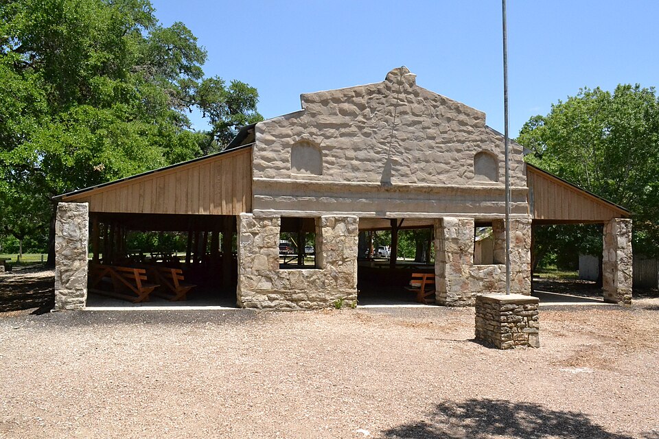
Listed on the National Register of Historic Places in 2004.
One of 57 National Register listings published here for Hays County · listed in 2004 · category: District.
Sources: the case file at the National Archives · the National Register database, National Park Service
Regional context, not property-specific evidence. The federal wildfire occurrence database lists 93 fires within 5 miles of Camp Ben McCulloch between 2004 and 2017, burning about 1,748 acres in total. None started naturally. 5 were recorded as arson. Distance is straight-line from the map coordinates, so a fire counted here may appear on a neighbouring settlement's page as well.
| Reported cause | Fires |
|---|---|
| Debris and open burning | 47 |
| Missing data/not specified/undetermined | 35 |
| Equipment and vehicle use | 5 |
| Arson/incendiarism | 5 |
| Recreation and ceremony | 1 |
The most recent of them, most recent first, with the day each was reported and the service that recorded it.
| Date | Cause | Size | Reported by | Name on the report |
|---|---|---|---|---|
| 9 September 2011 | Arson/incendiarism | under an acre | Texas A & M Forest Service | LA VENTANA |
| 8 September 2005 | Missing data/not specified/undetermined | 1.0 acres | Texas A & M Forest Service | not named |
| 7 September 2006 | Missing data/not specified/undetermined | 1.0 acres | Texas A & M Forest Service | not named |
| 20 September 2005 | Missing data/not specified/undetermined | 1.0 acres | Texas A & M Forest Service | not named |
| 14 September 2008 | Debris and open burning | 7.0 acres | Texas A & M Forest Service | not named |
| 6 August 2009 | Equipment and vehicle use | 45 acres | Texas A & M Forest Service | BRUNSON LANE |
| 29 August 2011 | Equipment and vehicle use | 5.0 acres | Texas A & M Forest Service | RAINBOW RANCH FIRE |
| 12 August 2011 | Arson/incendiarism | 2.0 acres | Texas A & M Forest Service | MT. GAINOR |
Regional context, not property-specific evidence. The federal mineral resources record lists 1 working within 5 miles of Camp Ben McCulloch: 1 past producer. None of them still produces. What was taken out: Flint. Distance is straight-line from the map coordinates, so a quarry counted here may appear on a neighbouring settlement's page as well.
| Where | Site | Commodity | Status | Recorded |
|---|---|---|---|---|
| Unnamed | Flint | Past Producer | Flint |
Regional context, not property-specific evidence. The National Weather Service names Driftwood, the town this property stands in, in 21 storm reports between 2002 and 2024: 8 hail, 7 flash flood, 4 thunderstorm wind, 1 tornado. No death or injury is recorded in these reports. Each account below is quoted exactly as the forecast office filed it, from the NOAA Storm Events Database, and each date opens the federal record of that event.
| When | Event | Place named | Harm | What the report says |
|---|---|---|---|---|
| October 2015 | Flash Flood | Driftwood | $10,000,000 | Massive flooding occurred along and just west of Interstate 35 on the morning of October 30th as a supercell thunderstorm merged with another line of storms. Torrential rains with rain rates of 7+ inches per hour caused massive runoff and quickly flooded the Blanco River, Onion Creek, Plum Creek, the San Marcos River and other smaller creeks and streams. Rainfall totals along I-35 were as high as 16 inches which led to significant flooding in Kyle and Buda as well. Sections of I-35 were shut down as water made the interstate impassable. Areas of San Marcos were inundated with water, trapping people and school kids. Dozens of swift water rescues continued during the morning and afternoon. The extent of the flooding was similar to the historic flood of October 1998. Hundreds of homes were flooded, as many as 100 of them completely destroyed. These estimates are probably low as FEMA assessments are still ongoing as of this writing. Infrastructure losses to roads and bridges are in the millions. There are no monetary loss estimates to uninsured/insured homes at the time of this writing. |
| October 2002 | Tornado (F0) | Driftwood | $70,000 | A small tornado struck just southwest of Driftwood, knocking 2 trucks off SH12. None of the vehicle occupants were injured. One of the trucks was operable after being righted. |
| January 2024 | Flash Flood | Driftwood | - | Thunderstorms produced heavy rain that led to flash flooding. A motorist was rescued from high water on Bear Creek Pass at Bear Creek near Driftwood. |
| June 2023 | Thunderstorm Wind | Driftwood | - | A thunderstorm produced wind gusts measured by a trained spotter at 51 kts (59 mph) two miles south of Sawyer Ranch Rd. and Hwy 290 east of Dripping Springs near Sycamore Springs Elementary School. |
| June 2023 | Thunderstorm Wind | Driftwood | - | A thunderstorm produced wind gusts measured at 59 mph by a trained spotter south of Sawyer Ranch Rd. and Hwy 290 near Driftwood. |
| August 2016 | Flash Flood | Driftwood | - | Thunderstorms produced heavy rain that caused flash flooding closing multiple low water crossings in Hays County including one on FM967 at Brangus Rd. |
| April 2015 | Hail | Driftwood | - | Nickel size hail was reported by the public in northwestern Hays County. |
| June 2014 | Thunderstorm Wind | Driftwood | - | A thunderstorm produced wind gusts estimated at 70 mph that damaged several roofs and blew down many large trees. |
| April 2014 | Thunderstorm Wind | Driftwood | - | A large tree was blown down. |
| April 2013 | Hail | Driftwood | - | A thunderstorm produced hail that covered the ground. The largest hail was golf ball size, but was mostly smaller. |
| May 2012 | Flash Flood | Driftwood | - | Thunderstorms produced heavy rain that flooded several roads in around Driftwood including RM 12. |
| May 2012 | Flash Flood | Driftwood | - | Thunderstorms produced heavy rain that flooded low water crossings closing several roads around Driftwood. |
| September 2010 | Flash Flood | Driftwood | - | Heavy rain from Tropical Storm Hermine produced flash flooding which closed RM 150 northeast of Wimberley. |
| March 2007 | Flood | Driftwood | - | Onion Creek near Driftwood crested at 11.04 ft at 1620 CST on March 30, where flood stage is 7 ft. |
| June 2004 | Flash Flood | Driftwood | - | Storms dropped an inch of rain across much of Hays County, with total to 3 inches between Driftwood and Dripping Spring. FM12 and FM150 were reported under water at many of the low water crossings. |
| May 2014 | Hail | Driftwood | - | no account filed |
| May 2011 | Hail | Driftwood | - | no account filed |
| May 2011 | Hail | Driftwood | - | no account filed |
| May 2011 | Hail | Driftwood | - | no account filed |
| May 2011 | Hail | Driftwood | - | no account filed |
| May 2011 | Hail | Driftwood | - | no account filed |
No historic map-sheet match is published for this property yet. That does not mean no map exists. This record needs a coordinate-quality review before it can be joined to a sheet boundary. Browse the county's mapped places while that work is pending.
Other National Register properties close enough to walk or drive between, ordered by distance from this one. Both positions come from the same geocoding pass that matched these properties to their map sheets.
| Photograph | Property | Distance | Listed |
|---|---|---|---|
 | Dr. Joseph M. and Sarah Pound Farmstead | 6.3 miles | 1995 |
 | Dripping Springs Downtown Historic District | 6.4 miles | 2013 |
 | M.G. Michaelis Ranch | 6.6 miles | 2003 |
| National Archives record | The nomination case file for reference 04001151 in Record Group 79. |
| Hays County | All 57 listed properties in this county. |