 Block
BlockFrom the record
One of 2 National Register listings published here for Polk County · listed in 2005 · category: Building.
Sources: the case file at the National Archives · the National Register database, National Park Service
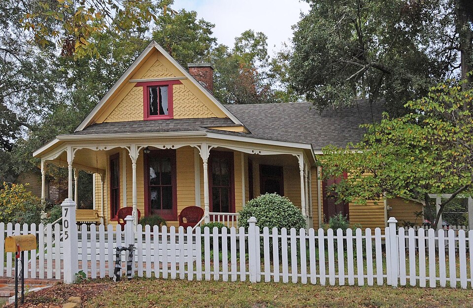
Listed on the National Register of Historic Places in 2005.
One of 2 National Register listings published here for Polk County · listed in 2005 · category: Building.
Sources: the case file at the National Archives · the National Register database, National Park Service
Regional context, not property-specific evidence. The federal wildfire occurrence database lists 177 fires within 5 miles of William Keenan and Nancy Elizabeth McCardell House between 1992 and 2020, burning about 525 acres in total. 4 started naturally. 2 were recorded as arson. Distance is straight-line from the map coordinates, so a fire counted here may appear on a neighbouring settlement's page as well.
| Reported cause | Fires |
|---|---|
| Debris and open burning | 127 |
| Missing data/not specified/undetermined | 27 |
| Smoking | 6 |
| Natural | 4 |
| Power generation/transmission/distribution | 4 |
| Equipment and vehicle use | 4 |
| Arson/incendiarism | 2 |
| Misuse of fire by a minor | 2 |
| Recreation and ceremony | 1 |
The most recent of them, most recent first, with the day each was reported and the service that recorded it.
| Date | Cause | Size | Reported by | Name on the report |
|---|---|---|---|---|
| 7 September 1995 | Debris and open burning | 1.0 acres | Texas A & M Forest Service | not named |
| 29 September 2007 | Debris and open burning | 8.0 acres | Texas A & M Forest Service | not named |
| 26 September 2011 | Power generation/transmission/distribution | 2.0 acres | Livingston Area | LIVINGSTON - 935 |
| 21 September 1997 | Debris and open burning | 1.0 acres | Texas A & M Forest Service | not named |
| 16 September 1999 | Missing data/not specified/undetermined | 1.0 acres | Texas A & M Forest Service | not named |
| 15 September 1999 | Debris and open burning | 2.0 acres | Texas A & M Forest Service | not named |
| 11 September 2008 | Debris and open burning | 5.0 acres | Texas A & M Forest Service | not named |
| 10 September 2011 | Smoking | 1.0 acres | Livingston Area | LIVINGSTON - 890 |
Regional context, not property-specific evidence. The National Weather Service names Livingston, the town this property stands in, in 56 storm reports between 1995 and 2025: 21 hail, 21 thunderstorm wind, 6 flash flood, 4 tornado. No death or injury is recorded in these reports. Each account below is quoted exactly as the forecast office filed it, from the NOAA Storm Events Database, and each date opens the federal record of that event.
| When | Event | Place named | Harm | What the report says |
|---|---|---|---|---|
| February 1998 | Thunderstorm Wind | Livingston | $14,000,000 | Straight line wind damage across the entire county from west to east. Lake Livingston Dam measured 134 mph wind gusts before their equipment blew away. The hardest hit are was from the Tobacco Patch community to the west of the Livingston area, though major damage occurred across the majority of the county. Numerous trees/powerpoles down, 18 homes completely destroyed, 172 with major damage, 180 with moderate to minor damage. Timber industry took a large loss due to the number of downed trees. Governor George Bush Jr. declared Polk County a disaster area on 3/11/98. |
| May 2004 | Flash Flood | Livingston | $500,000 | 75 to 100 Livingston homes and businesses damaged from flooding at FM 146 and US 59; northbound and southbound lanes of US 59 closed. |
| May 2004 | Thunderstorm Wind | Livingston | $135,000 | Numerous trees down between Hwy 146 and Hwy 190 and in the Indian Hills Subdivision near Lake Livingston where one tree fell on a home. |
| May 2004 | Flash Flood | Livingston | $100,000 | Homes flooded in the Crystal Lake Subdivision. |
| May 1999 | Thunderstorm Wind | Livingston | $60,000 | Porch torn off house near FM 3126 and FM 350 south. Trees down along Hwys. 62, 352, and 3126 west of Livingston. |
| October 2006 | Flash Flood | Livingston | $50,000 | Heavy rains impacted five to six homes. There were numerous flooded roads with several eastern county road closures. Several bridges were under water. |
| November 2004 | Thunderstorm Wind | Livingston | $50,000 | Building damage with power lines down in the Indian Hills Subdivision along FM 2457 near Lake Livingston. |
| May 2006 | Hail | Livingston | $25,000 | Golf ball size hail at FM 2457 and Highway 90. |
| May 1999 | Thunderstorm Wind | Livingston | $25,000 | Car swept off road near Livingston. |
| July 2004 | Thunderstorm Wind | Livingston | $20,000 | Trees down on power lines. |
| February 2011 | Thunderstorm Wind | Livingston | $15,000 | Numerous trees were downed in the towns of Onalaska and Livingston, with a roof blown off of a home in Livingston. |
| February 2008 | Thunderstorm Wind | Livingston | $15,000 | Thunderstorm winds blew over a large tree at a Livingston apartment complex, damaging a vehicle. There were also four apartment units that suffered minor damage. |
| October 2001 | Thunderstorm Wind | Livingston | $10,000 | Sheriff's office reported trees and power lines down in Livingston. |
| November 1996 | Thunderstorm Wind | Livingston | $10,000 | no account filed |
| June 2013 | Thunderstorm Wind | Livingston | $5,000 | A severe thunderstorm downed trees near Highway 190. |
| April 2006 | Hail | Livingston | $5,000 | Hail reported at Livingston Police Station. |
| February 2003 | Hail | Livingston | $5,000 | 3/4 inch hail. |
| February 2003 | Hail | Livingston | $5,000 | 3/4 inch hail. |
| March 2002 | Hail | Livingston | $5,000 | Sheriff reported 3/4 inch hail along eastern shore of Lake Livingston at Onalaska and Blanchard, and also in Livingston. |
| January 1998 | Thunderstorm Wind | Livingston | $5,000 | Trees blown down onto powerlines. |
| November 1995 | Thunderstorm Wind | Livingston | $5,000 | Sheriff reported trees blown down in Livingston. |
| January 1997 | Hail | Livingston | $5,000 | no account filed |
| January 1997 | Thunderstorm Wind | Livingston | $5,000 | no account filed |
| April 1997 | Hail | Livingston | $5,000 | no account filed |
| June 1996 | Hail | Livingston | $5,000 | no account filed |
| August 1996 | Hail | Livingston | $5,000 | no account filed |
| December 1995 | Hail | Livingston | $5,000 | no account filed |
| May 2006 | Hail | Livingston | $4,000 | Penny size hail. |
| March 2005 | Thunderstorm Wind | Livingston | $4,000 | Tree downed on power lines on Highway 350. |
| May 2005 | Hail | Livingston | $4,000 | Nickel size hail. |
| March 2005 | Hail | Livingston | $4,000 | no account filed |
| February 2013 | Thunderstorm Wind | Livingston | $3,000 | A line of severe thunderstorms downed trees along Highway 190 east of Livingston. |
| August 2011 | Thunderstorm Wind | Livingston | $3,000 | Severe thunderstorm winds downed trees in Livingston. |
| December 2002 | Hail | Livingston | $3,000 | 0.75 inch hail. |
| August 2002 | Hail | Livingston | $3,000 | Hail at Crystal Lakes Estates. |
| October 2001 | Hail | Livingston | $2,000 | no account filed |
| May 2009 | Hail | Livingston | $1,000 | Quarter sized hail occurred in downtown Livingston. |
| March 2025 | Hail | Livingston | - | A trained storm spotter reported 1 inch hail in Livingston. |
| January 2024 | Flash Flood | Livingston | - | Access road to Crystal Lakes Subdivision was washed out. |
| May 2024 | Thunderstorm Wind | Livingston | - | Power lines and tree limbs were damaged near Highway 190. |
| May 2024 | Hail | Livingston | - | Quarter sized hail was observed near Highway 190. |
| May 2024 | Thunderstorm Wind | Livingston | - | Trees were downed on multiple roads, including FM 350, SH 146, and C M Hardy Road. |
| April 2024 | Flash Flood | Livingston | - | All lanes of Hwy 59 were closed near the Baskin Loop Overpass due to flash flooding. |
| May 2024 | Flash Flood | Livingston | - | Portions of Hwy 146 and BU 59 were impassable due to flash flooding. |
| April 2015 | Thunderstorm Wind | Livingston | - | Thunderstorm winds downed a tree off of Highway 190 to the east of Livingston. |
| March 2014 | Hail | Livingston | - | Quarter sized hail was observed in Livingston. |
| June 2008 | Thunderstorm Wind | Livingston | - | A strong thunderstorm wind gust was estimated at the sheriff's office in Livingston. |
| April 2007 | Funnel Cloud | Livingston | - | Funnel cloud reported near Highway 190 East. |
| May 2007 | Funnel Cloud | Livingston | - | Funnel cloud reported 3 miles north of US Route 190. |
| May 2007 | Tornado (EF0) | Livingston | - | Spotted just west of Livingston near Highway 190 and Highway 59. |
| May 2007 | Hail | Livingston | - | Golf ball size hail reported along FM 350. |
| June 2004 | Funnel Cloud | Livingston | - | Funnel cloud sighted south of Highway 190. |
| November 2004 | Funnel Cloud | Livingston | - | Funnel sighted near the intersection of Highways 190 and 350 near Highway 59. |
| June 2003 | Tornado (F0) | Livingston | - | No damage. |
| June 2003 | Tornado (F0) | Livingston | - | No damage. |
| May 1997 | Tornado (F0) | Livingston | - | DPS amd EM reported tornado during the time period. No injuries or damages reported. |
No historic map-sheet match is published for this property yet. That does not mean no map exists. This record needs a coordinate-quality review before it can be joined to a sheet boundary. Browse the county's mapped places while that work is pending.
Other National Register properties close enough to walk or drive between, ordered by distance from this one. Both positions come from the same geocoding pass that matched these properties to their map sheets.
| Photograph | Property | Distance | Listed |
|---|---|---|---|
 | Polk County Courthouse and 1905 Courthouse Annex | 0.4 miles | 2001 |
| National Archives record | The nomination case file for reference 05000863 in Record Group 79. |
| Polk County | All 2 listed properties in this county. |