 Block
BlockFrom the record
One of 4 National Register listings published here for Rusk County · listed in 2005 · category: Building.
Sources: the case file at the National Archives · the National Register database, National Park Service
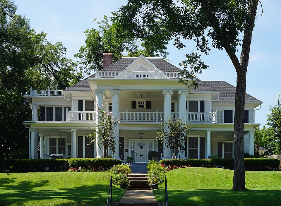
Listed on the National Register of Historic Places in 2005.
One of 4 National Register listings published here for Rusk County · listed in 2005 · category: Building.
Sources: the case file at the National Archives · the National Register database, National Park Service
Regional context, not property-specific evidence. The federal wildfire occurrence database lists 487 fires within 5 miles of Elias and Mattie Crim House between 1992 and 2020, burning about 1,808 acres in total. 14 started naturally. 17 were recorded as arson. Distance is straight-line from the map coordinates, so a fire counted here may appear on a neighbouring settlement's page as well.
| Reported cause | Fires |
|---|---|
| Debris and open burning | 227 |
| Missing data/not specified/undetermined | 163 |
| Power generation/transmission/distribution | 24 |
| Equipment and vehicle use | 21 |
| Arson/incendiarism | 17 |
| Natural | 14 |
| Smoking | 7 |
| Misuse of fire by a minor | 6 |
| Fireworks | 4 |
| Recreation and ceremony | 3 |
| Railroad operations and maintenance | 1 |
The most recent of them, most recent first, with the day each was reported and the service that recorded it.
| Date | Cause | Size | Reported by | Name on the report |
|---|---|---|---|---|
| 9 September 2017 | Missing data/not specified/undetermined | under an acre | Texas A & M Forest Service | GRASS FIRE |
| 9 September 2011 | Missing data/not specified/undetermined | under an acre | Texas A & M Forest Service | GRASSFIRE |
| 9 September 2000 | Equipment and vehicle use | 1.0 acres | Texas A & M Forest Service | HENDERSON - 495 |
| 8 September 2000 | Arson/incendiarism | 1.0 acres | Texas A & M Forest Service | HENDERSON - 491 |
| 8 September 1993 | Debris and open burning | 1.0 acres | Texas A & M Forest Service | not named |
| 7 September 2011 | Power generation/transmission/distribution | 42 acres | Texas A & M Forest Service | HENDERSON - 520 |
| 7 September 2010 | Debris and open burning | under an acre | Texas A & M Forest Service | BRUSH FIRE |
| 6 September 2012 | Power generation/transmission/distribution | under an acre | Texas A & M Forest Service | GRASSFIRE |
Regional context, not property-specific evidence. The federal mineral resources record lists 11 workings within 5 miles of Elias and Mattie Crim House: 11 producers. All of them still produce. What was taken out: Kaolin, Fire Clay (Refractory), Kaolin, Kaolin, Fire Clay (Refractory), Clay. Distance is straight-line from the map coordinates, so a quarry counted here may appear on a neighbouring settlement's page as well.
| Where | Site | Commodity | Status | Recorded |
|---|---|---|---|---|
| Henderson Brick Plant & Pit | Clay | Producer | ||
| Unnamed Pit | Kaolin, Fire Clay (Refractory) | Producer | Sedimentary | |
| Unnamed Pit | Kaolin, Fire Clay (Refractory) | Producer | Sedimentary | |
| Anderson Pit | Fire Clay (Refractory), Kaolin | Producer | Sedimentary | |
| Plastic Pits | Fire Clay (Refractory), Kaolin | Producer | Sedimentary | |
| Wylie Pit | Fire Clay (Refractory), Kaolin | Producer | Sedimentary | |
| Henderson Clay Products Anderson | Kaolin | Producer | ||
| Henderson Clay Products Pit | Kaolin | Producer | ||
| Henderson Clay Products Plant | Kaolin | Producer | ||
| Henderson Clay Products Plastic Pit | Kaolin | Producer |
Regional context, not property-specific evidence. The National Weather Service names Henderson, the town this property stands in, in 151 storm reports between 1993 and 2025: 73 thunderstorm wind, 59 hail, 11 flash flood, 5 lightning. The reports record 1 death and 4 injuries. Each account below is quoted exactly as the forecast office filed it, from the NOAA Storm Events Database, and each date opens the federal record of that event.
| When | Event | Place named | Harm | What the report says |
|---|---|---|---|---|
| November 1994 | Thunderstorm Wind | Henderson | 1 killed, 2 hurt, $50,000 | A 3-week old child was killed and two persons sustained minor injuries when a mobile home was rolled by high winds and heavily damaged. Roofs were partially blown off two houses and a barn was damaged. Damage was estimated at over $25,000. M01M |
| May 2022 | Tornado (EF2) | Henderson | 1 hurt, $100,000 | An EF-2 tornado with estimated maximum winds of 115 mph developed just west of County Road 222 on the east side of Henderson and continued northeast for just over eight miles, uprooting and snapping thousands of trees and causing damage to some structures. The tornado was at its widest and strongest crossing County Road 262, FM 1251 East, County Road 324, and County Road 327 where extensive snapping of pine and hardwood trees warranted an estimated peak wind speed of 115 mph, a low EF-2 rating on the Enhanced Fujita Scale. The one injury occurred along County Road 262 where a male outside was struck by a falling tree. Several residences received various levels of roof damage, mostly due to falling trees. The tornado weakened as it lifted west of Martin Lake, with the same storm spawning another tornado just to the east near Martin Lake. |
| August 2020 | Lightning | Henderson | 1 hurt | A 54 year old male groundskeeper was struck by lightning near a shed at the Henderson Country Club in Henderson. The lightning entered his head and came out through his left hand and leg. The victim suffered only minor injuries, and was released from the hospital the next day. |
| October 2009 | Thunderstorm Wind | Henderson | $250,000 | Strong winds downed trees throughout the county. One tree fell on top of a home in the 700 block of Slaydon Street. Several metal buildings at the Lowe's Hardware Store on US Hwy. 79 South were destroyed and scattered across a vacant lot. Another large tree fell on a home on Shawnee Trail with trees on a home in the 800 block of South Main Street. Trees were also downed on the carport of a residence on FM 3135. |
| June 1998 | Thunderstorm Wind | Henderson | $55,000 | no account filed |
| May 2017 | Thunderstorm Wind | Henderson | $50,000 | Numerous trees were downed across much of Rusk County from damaging straight line wind gusts. One large tree fell on a home on the 3600 Block of FM 3310 south of Henderson. |
| May 2008 | Tornado (EF1) | Henderson | $50,000 | An EF1 tornado occurred northeast of Henderson, Texas along Hwy 43. A 24 by 24 foot foot metal building was completely destroyed and minor damage occurred to a house owned by the owner of a construction company. Numerous trees were snapped and uprooted along the path which ended 5.5 miles east along FM 1251. A hay barn was partially destroyed and several trees were uprooted and snapped around a home along FM 1251 in the Church Hill community. The path was 100 yards wide at its widest point. The tornado lifted before reaching CR 328 in Rusk County. |
| May 2015 | Lightning | Henderson | $30,000 | A lightning strike resulted in a structural fire in Henderson, Texas. |
| May 1999 | Thunderstorm Wind | Henderson | $30,000 | Winds blew the roof off a building in Henderson Square. |
| June 2019 | Lightning | Henderson | $25,000 | Lightning struck a home along Highway 79 East, starting a fire in the attic. |
| January 1999 | Thunderstorm Wind | Henderson | $25,000 | Twelve large trees down. One uprooted tree fell on a house at FM3135 and Hwy 79. |
| May 2012 | Thunderstorm Wind | Henderson | $20,000 | Numerous large trees were downed in and around Henderson, Texas. Local Emergency Manager reported that a tree fell on a house in town, along with numerous other roadways being blocked by fallen trees. Hwy. 42 and FM. 1249 were hit the worst. |
| June 2004 | Thunderstorm Wind | Henderson | $20,000 | A downburst toppled several trees which damaged two homes and a pickup truck. Damage path was 2 miles long and one half mile wide. |
| April 2018 | Lightning | Henderson | $10,000 | Lightning struck a home at the 500 block of South Van Buren Street, which split a large limb from a tree and landed/damaged the chimney of the home. |
| June 2011 | Thunderstorm Wind | Henderson | $10,000 | An 83 year old man was traveling northbound on FM. 225, a half mile north of CR. 438 when his vehicle struck a downed tree. He was taken to a local hospital where he later died of his injuries. |
| August 2010 | Lightning | Henderson | $10,000 | Lightning caused a house fire on CR. 214D near Hwy. 43. There were no report of injuries. |
| October 1994 | Thunderstorm Wind | Henderson | $5,000 | At 1 S New Salem (17 SW Henderson), trees were blown down by high winds. |
| June 2005 | Thunderstorm Wind | Henderson | $3,000 | A tractor trailer rig was blown over near Laneville. |
| April 1999 | Flash Flood | Henderson | $2,000 | Flooding took place near the water treatment plant for the town of Henderson. |
| March 2025 | Hail | Henderson | - | Penny size hail reported southeast of Henderson via Mping. |
| May 2025 | Thunderstorm Wind | Henderson | - | A tree was downed onto CR 308 near the intersection of FM 840. |
| August 2025 | Thunderstorm Wind | Henderson | - | A tree was blown down on FM 3135 on the east side of Henderson. |
| June 2024 | Thunderstorm Wind | Henderson | - | Multiple trees downed in Henderson. |
| June 2024 | Thunderstorm Wind | Henderson | - | Wind gusts reported up to 75 mph in Henderson. |
| June 2024 | Thunderstorm Wind | Henderson | - | Numerous trees and power lines downed in Henderson. |
| April 2024 | Thunderstorm Wind | Henderson | - | A large tree downed on FM Road 840 near Pecan Creek and on FM Road 13 just inside Loop 571 in Henderson. |
| May 2024 | Thunderstorm Wind | Henderson | - | Multiple trees downed in Henderson. |
| March 2023 | Hail | Henderson | - | Nickel size hail reported on County Road 405D. |
| March 2023 | Hail | Henderson | - | Dime to nickel size hail reported on the southeast side of Henderson along Highway 259. |
| March 2023 | Thunderstorm Wind | Henderson | - | Tree downed along County Road 311 and County Road 317 south of Henderson. |
| April 2023 | Hail | Henderson | - | Quarter size hail fell near the intersection of Van Buren Street and Highway 64 in Henderson. |
| April 2023 | Hail | Henderson | - | Quarter to golfball size hail fell throughout the city of Henderson. |
| April 2023 | Hail | Henderson | - | Hail up the size of baseballs fell throughout the city of Henderson. Several reports were received of windshields and skylights broken, along with damaged traffic signals with power outages. |
| June 2023 | Hail | Henderson | - | Baseball size hail reported at Henderson High School. |
| April 2022 | Thunderstorm Wind | Henderson | - | A tree was blown down on Highway 301 just outside of the Henderson city limits. |
| April 2022 | Thunderstorm Wind | Henderson | - | A roof was blown off of a building in Downtown Henderson. |
| April 2021 | Hail | Henderson | - | Teacup size hail fell several miles southeast of Henderson. Report from mPING. |
| April 2021 | Hail | Henderson | - | Baseball size hail fell at the intersection of Highway 259 and County Road 317. |
| April 2021 | Hail | Henderson | - | Half dollar size hail fell several miles southeast of Henderson. Report from mPING. |
| June 2021 | Thunderstorm Wind | Henderson | - | A tree was blown down across Highway 259 just south of Henderson. |
| October 2021 | Thunderstorm Wind | Henderson | - | Tree down on County Road 3397, FM 782 near County Road 2186, FM 225 2 miles north of Hwy 284, FM 2496 near County Road 3161 and State Hwy 42 northwest of Hwy 795. |
| March 2020 | Thunderstorm Wind | Henderson | - | Trees were downed on FM 840 a couple of miles southeast of Henderson which forced the closure of the road. |
| March 2020 | Thunderstorm Wind | Henderson | - | Over 25 trees were blown down across Central and Southern Rusk County. |
| March 2020 | Flash Flood | Henderson | - | Water entered a home on Timberline Street near Highway 79 in the southern sections of Henderson. |
| January 2020 | Thunderstorm Wind | Henderson | - | Trees were downed on Farm to Market Road 840 southeast of Henderson. |
| March 2019 | Thunderstorm Wind | Henderson | - | Trees and power lines were downed in Henderson. |
| October 2019 | Hail | Henderson | - | A picture was posted to Facebook of penny size hail that fell in Henderson. |
| May 2019 | Thunderstorm Wind | Henderson | - | Several trees were downed on Maple Street behind O'Reilly's Auto Parts on Highway 79. |
| December 2018 | Thunderstorm Wind | Henderson | - | Numerous trees were downed across much of Rusk County. |
| October 2018 | Flood | Henderson | - | A vehicle drove into a localized area of flooding on Parnell Street. The occupants of the vehicle were able to safely leave their vehicle. The street was briefly closed to allow the water to recede. |
| October 2018 | Thunderstorm Wind | Henderson | - | Several trees were downed in Henderson. |
| May 2017 | Hail | Henderson | - | Penny size hail fell just east of Henderson. |
| April 2016 | Hail | Henderson | - | Nickel size hail fell in Henderson. |
| April 2016 | Flash Flood | Henderson | - | Farm to Market Road 3135 from north of Highway 79 to just south of Farm to Market Road 1251 was closed due to flooding. |
| April 2015 | Thunderstorm Wind | Henderson | - | Numerous trees were downed in and around Henderson, Texas. |
| May 2015 | Thunderstorm Wind | Henderson | - | Wind gusts estimated to near 60 mph by county Emergency Manager. |
| May 2015 | Thunderstorm Wind | Henderson | - | A large tree was downed on Fordall near the Civic Center. |
| April 2015 | Hail | Henderson | - | Dime size hail reported at the intersection of Hwy. 259 and Hwy. 79. |
| October 2014 | Thunderstorm Wind | Henderson | - | Numerous trees and powerlines were downed in the southern portion of Henderson, Texas on Hwy. 79 and CR. 407. |
| October 2014 | Thunderstorm Wind | Henderson | - | Numerous trees and powerlines were downed throughout the entire county. |
No historic map-sheet match is published for this property yet. That does not mean no map exists. This record needs a coordinate-quality review before it can be joined to a sheet boundary. Browse the county's mapped places while that work is pending.
Other National Register properties close enough to walk or drive between, ordered by distance from this one. Both positions come from the same geocoding pass that matched these properties to their map sheets.
| Photograph | Property | Distance | Listed |
|---|---|---|---|
 | Henderson Commercial Historic District | 0.2 miles | 1995 |
| National Archives record | The nomination case file for reference 05000892 in Record Group 79. |
| Rusk County | All 4 listed properties in this county. |