BlockBefore
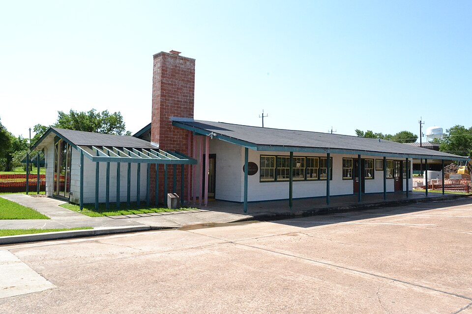
Photograph of Alden B. Dow Office and Lake Jackson City Hall
Photograph by 25or6to4, CC BY-SA 3.0. Via Wikimedia Commons.

Alden B. Dow Office and Lake Jackson City Hall

Listed on the National Register of Historic Places in 2010.

From the record

“Dow Office and Lake Jackson City Hall is a historic, single-story, wood-frame commercial building in Lake Jackson, Texas, located near Freeport. Built in 1943, it was designed by noted Michigan architect Alden B.”

Wikipedia article Alden B. Dow Office and Lake Jackson City Hall, CC BY-SA 4.0.

One of 12 National Register listings published here for Brazoria County · listed in 2010 · category: Building.

Sources: the Wikipedia article · the case file at the National Archives · the National Register database, National Park Service
The listing

  • What is counted as historic. The nomination lists 1 building as contributing to the listing.
  • Listed as. Dow, Alden B., Office and Lake Jackson City Hall - the National Register files a house under its owner's surname.
  • Address. 101 S. Parking Pl., Lake Jackson, 77566
  • When was it listed? March 2010
  • Category. building
  • Census division. Brazosport
  • Architectural style. modern architecture
  • Architect. Alden B. Dow
  • National Register reference number. 10000050 - the number the National Park Service assigned this property when it was listed, and the key its nomination file is catalogued under at the National Archives.

Fires near this property

9 since 2008

Regional context, not property-specific evidence. The federal wildfire occurrence database lists 9 fires within 5 miles of Alden B. Dow Office and Lake Jackson City Hall between 2008 and 2012, burning about 107 acres in total. None started naturally. None was recorded as arson. Distance is straight-line from the map coordinates, so a fire counted here may appear on a neighbouring settlement's page as well.

Reported cause Fires
Debris and open burning6
Misuse of fire by a minor1
Recreation and ceremony1
Missing data/not specified/undetermined1

The most recent of them, most recent first, with the day each was reported and the service that recorded it.

DateCause SizeReported by Name on the report
12 August 2012Debris and open burningunder an acreTexas A & M Forest Service2012-000259
1 March 2009Recreation and ceremony1.0 acresTexas A & M Forest ServiceMAMOTH LAKE
3 February 2009Debris and open burning100 acresTexas A & M Forest ServiceSTEVEN F AUSTIN
19 February 2009Debris and open burning1.0 acresTexas A & M Forest ServiceBRUSH FIRE
13 February 2009Debris and open burning1.0 acresTexas A & M Forest ServiceBRUSH FIRE
9 January 2009Debris and open burning1.0 acresTexas A & M Forest ServiceGRASS FIRE
31 January 2009Misuse of fire by a minor1.0 acresTexas A & M Forest ServiceMOCKINGBIRD
22 January 2009Missing data/not specified/undetermined1.0 acresTexas A & M Forest ServiceGRASS FIRE

Every fire recorded in Brazoria County

Mines and quarries near this property

4 within 5 miles

Regional context, not property-specific evidence. The federal mineral resources record lists 4 workings within 5 miles of Alden B. Dow Office and Lake Jackson City Hall: 4 producers. All of them still produce. What was taken out: Sand and Gravel, Construction. Distance is straight-line from the map coordinates, so a quarry counted here may appear on a neighbouring settlement's page as well.

Where SiteCommodity StatusRecorded
Leggett Sand PitSand and Gravel, ConstructionProducer
Miller Sand PitsSand and Gravel, ConstructionProducer
Moller PitSand and Gravel, ConstructionProducer
Riggs Oak Sand PitSand and Gravel, ConstructionProducer

Every working recorded in Brazoria County

Storms near this property

16 since 1993

Regional context, not property-specific evidence. The National Weather Service names Lake Jackson, the town this property stands in, in 16 storm reports between 1993 and 2015: 8 thunderstorm wind, 2 hail, 2 tornado, 2 flash flood. No death or injury is recorded in these reports. Each account below is quoted exactly as the forecast office filed it, from the NOAA Storm Events Database, and each date opens the federal record of that event.

WhenEvent Place namedHarm What the report says
February 1998Thunderstorm WindLake Jackson$125,000Trees downed on houses, roof partially blown off American Apartments, numerous powerlines down, McDonalds sign blown down, softball fence blown down.
October 2015Tornado (EF0)Lake Jackson$50,000An EF-0 tornado tracked from a subdivision south of the Brazos Mall knocking down fences and shallow rooted trees. The tornado then tracked across Hobby Lobby and the eastern end of the mall where it caused roof damage. It then continued into a subdivision to the northeast of the mall uprooting several large trees. Estimated peak wind speed was 85 mph.
June 2007LightningLake Jackson$30,000Lightning struck a home on the 200 block of Peppermint Drive casing a fire. The home was saved with significant roof and upstairs interior burn damage and some lower floor water damage.
September 2000Thunderstorm WindLake Jackson$25,000Trees down.
June 1995Thunderstorm WindLake Jackson$20,000Tree blown into a house in Lake Jackson. There were also trees blown down and power out in the area.
April 2015Thunderstorm WindLake Jackson$15,000Thunderstorm winds downed several trees and many tree limbs.
May 2006Thunderstorm WindLake Jackson$11,000Trees down.
September 2003Flash FloodLake Jackson$10,000Bumper-high street flooding. Water threatening homes in the Winding Woods subdivision.
April 2015LightningLake Jackson$5,000A lightning strike caused damage to a structure.
April 2002HailLake Jackson$5,000Lake Jackson and Richwood Village received 3/4 inch Hail.
September 2002Tornado (F0)Lake Jackson$5,000Tornado sighted west Lake Jackson and CR 332 (very brief touchdown).
May 1993HailLake Jackson$5,000Brazoria County Sheriff Department reported quarter-size hail in the Wal-Mart parking lot.
April 1997Thunderstorm WindLake Jackson$5,000no account filed
December 2002Thunderstorm WindLake Jackson$1,000Truck blown off road.
April 2015Thunderstorm WindLake Jackson-Numerous trees will downed by severe thunderstorm wind gusts and blocking streets within town.
April 2015Flash FloodLake Jackson-Heavy rain caused residential street flooding that left some roadways impassable across northern Lake Jackson.

Every storm recorded in Brazoria County

Map coverage status

No historic map-sheet match is published for this property yet. That does not mean no map exists. This record needs a coordinate-quality review before it can be joined to a sheet boundary. Browse the county's mapped places while that work is pending.

Listed places nearby

3 within 8 miles

Other National Register properties close enough to walk or drive between, ordered by distance from this one. Both positions come from the same geocoding pass that matched these properties to their map sheets.

Photograph PropertyDistance Listed
Durazno Plantation5.9 miles1980
Brazoria Bridge6.6 miles1991
Henry Smith Statue7.3 miles2018

Sources for this property

National Archives recordThe nomination case file for reference 10000050 in Record Group 79.
Wikipedia articleCommunity-written account of this property, licensed CC BY-SA.
Brazoria CountyAll 12 listed properties in this county.

Provenance

  • Listing record. National Park Service National Register of Historic Places, listed-properties dataset, current to 2026-05-22.
  • Map join. Address geocoded through the United States Census geocoder, then tested against the published boundary of every sheet in the USGS Historical Topographic Map Collection.
  • How this page is made. Listing fields come from federal records; map-sheet coverage is a labelled coordinate-to-boundary calculation, not a source-field claim.
  • Wildfire. Short, Karen C. 2022. Spatial wildfire occurrence data for the United States, 1992-2020 [FPA_FOD_20221014]. 6th Edition. Fort Collins, CO: Forest Service Research Data Archive. https://doi.org/10.2737/RDS-2013-0009.6 Collected with United States Government funding and usable without additional permissions or fees.
  • Mines and quarries. USGS Mineral Resources Data System (MRDS) https://mrdata.usgs.gov/mrds/ A work of the United States government, no copyright under 17 U.S.C. 105.
  • Storms. NOAA National Centers for Environmental Information, Storm Events Database https://www.ncei.noaa.gov/stormevents/ A work of the United States government, no copyright under 17 U.S.C. 105. Narratives are quoted verbatim from the National Weather Service report and are not edited or summarised.