
BlockBefore
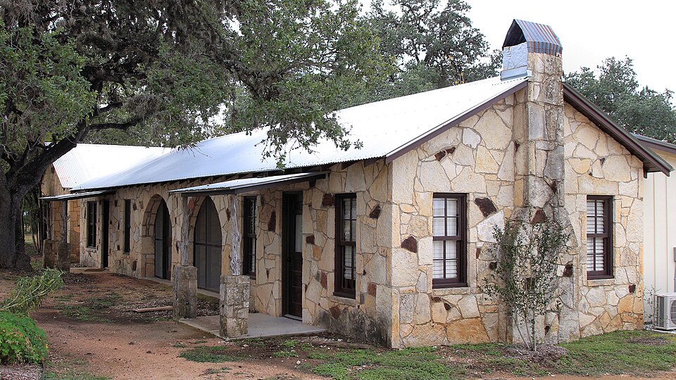
Photograph of River Oaks Courts
Photograph by Larry D. Moore, CC BY 4.0. Via Wikimedia Commons.

River Oaks Courts

Listed on the National Register of Historic Places in 2019.

From the record

“The River Oaks Courts, located at 14349 TX 16 in Medina, Texas, United States, were added to the National Register of Historic Places on January 28, 2019.”

Wikipedia article River Oaks Courts, CC BY-SA 4.0.

One of 5 National Register listings published here for Bandera County · listed in 2019 · category: District.

Sources: the Wikipedia article · the National Register database, National Park Service

The listing

  • Address. 14349 TX 16, Medina, 78055
  • When was it listed? January 2019
  • Category. district
  • Census division. Medina
  • National Register reference number. 100003354 - assigned by the National Park Service when the property was listed.

Fires near this property

3 since 2007

Regional context, not property-specific evidence. The federal wildfire occurrence database lists 3 fires within 5 miles of River Oaks Courts between 2007 and 2010, burning about 850 acres in total. None started naturally. None was recorded as arson. Distance is straight-line from the map coordinates, so a fire counted here may appear on a neighbouring settlement's page as well.

Reported cause Fires
Debris and open burning2
Equipment and vehicle use1

The most recent of them, most recent first, with the day each was reported and the service that recorded it.

DateCause SizeReported by Name on the report
6 March 2007Equipment and vehicle use600 acresTexas A & M Forest ServiceMOFFETT
21 February 2010Debris and open burning100 acresTexas A & M Forest ServiceKROLY ROAD FIRE
15 October 2009Debris and open burning150 acresTexas A & M Forest ServiceHILLSIDE IN MEDINA

Every fire recorded in Bandera County

Storms near this property

30 since 1996

Regional context, not property-specific evidence. The National Weather Service names Medina, the town this property stands in, in 30 storm reports between 1996 and 2024: 23 hail, 5 flash flood, 1 funnel cloud, 1 thunderstorm wind. No death or injury is recorded in these reports. Each account below is quoted exactly as the forecast office filed it, from the NOAA Storm Events Database, and each date opens the federal record of that event.

WhenEvent Place namedHarm What the report says
July 2007Flash FloodMedina$100,000Extremely heavy rainfall was reported from eastern Bandera County into northern Medina County. Most parts of eastern Bandera County reported 3 to 4 inches of rain, but the highest amount was in Bandera where up to 8 inches fell. Flash flooding was both widespread and severe, closing SH16, SH173, FM1283 and FM470.
June 2007Flash FloodMedina$10,000Thunderstorms produced 2 to 3 inch totals from Leakey in Real County eastward to Medina and Vanderpool in Bandera County. Highest totals in Bandera County were 5 inches at Vanderpool. FM187 and FM337 were closed to high water, with severe flooding along FM187.
April 2022Thunderstorm WindMedina$2,000A thunderstorm produced wind gusts estimated at 65 mph that knocked down some tree limbs and small poles in Medina.
May 2024HailMedina-A thunderstorm produced hail up to the size of golf balls in Medina.
May 2022HailMedina-A thunderstorm produced golf ball size hail between Medina and Bandera.
April 2022HailMedina-A thunderstorm produced dime to golf ball size hail in Medina.
April 2022HailMedina-A thunderstorm produced two inch diameter hail in Medina.
April 2022HailMedina-A thunderstorm produced 2.5 inch diameter hail in Medina.
April 2022HailMedina-A thunderstorm produced quarter size hail east of Medina.
April 2022HailMedina-A thunderstorm produced 2.5 inch diameter hail in Medina.
May 2020HailMedina-A thunderstorm produced quarter size hail in Medina.
June 2019HailMedina-A thunderstorm produced quarter size hail in rural Bandera County between Medina and Center Point.
January 2017HailMedina-A thunderstorm produced 2.5 inch hail that broke a sky light in a house.
May 2016Flash FloodMedina-Thunderstorms produced heavy rain that caused flash flooding sending water from the Medina River over Patterson Ave.
May 2014Flash FloodMedina-Thunderstorms produced heavy rain that caused flash flooding. Flood waters, filled with debris, closed numerous roads in Medina.
April 2010HailMedina-A thunderstorm produced three quarter to one inch hail which covered the ground.
July 2007Flash FloodMedina-Scattered thunderstorms over Bandera, Real and Uvalde Counties produced from 3 to 4 inches of rain, causing flash flooding of SH16 at FM2107 northwest of Medina.
January 2017HailMedina-no account filed
March 2016HailMedina-no account filed
September 2011HailMedina-no account filed
March 2006HailMedina-no account filed
April 2006HailMedina-no account filed
April 2005HailMedina-no account filed
May 2002HailMedina-no account filed
February 1998HailMedina-no account filed
May 1996Funnel CloudMedina-no account filed

Every storm recorded in Bandera County

Map coverage status

No historic map-sheet match is published for this property yet. That does not mean no map exists. This record needs a coordinate-quality review before it can be joined to a sheet boundary. Browse the county's mapped places while that work is pending.

Sources for this property

National Archives recordThe nomination case file for reference 100003354 in Record Group 79.
Wikipedia articleCommunity-written account of this property, licensed CC BY-SA.
Bandera CountyAll 5 listed properties in this county.

Provenance

  • Listing record. National Park Service National Register of Historic Places, listed-properties dataset, current to 2026-05-22.
  • Map join. Address geocoded through the United States Census geocoder, then tested against the published boundary of every sheet in the USGS Historical Topographic Map Collection.
  • How this page is made. Listing fields come from federal records; map-sheet coverage is a labelled coordinate-to-boundary calculation, not a source-field claim.
  • Wildfire. Short, Karen C. 2022. Spatial wildfire occurrence data for the United States, 1992-2020 [FPA_FOD_20221014]. 6th Edition. Fort Collins, CO: Forest Service Research Data Archive. https://doi.org/10.2737/RDS-2013-0009.6 Collected with United States Government funding and usable without additional permissions or fees.
  • Storms. NOAA National Centers for Environmental Information, Storm Events Database https://www.ncei.noaa.gov/stormevents/ A work of the United States government, no copyright under 17 U.S.C. 105. Narratives are quoted verbatim from the National Weather Service report and are not edited or summarised.