 Block
BlockFrom the record
One of 9 National Register listings published here for Gregg County · listed in 2019 · category: Building.
Sources: the National Register database, National Park Service
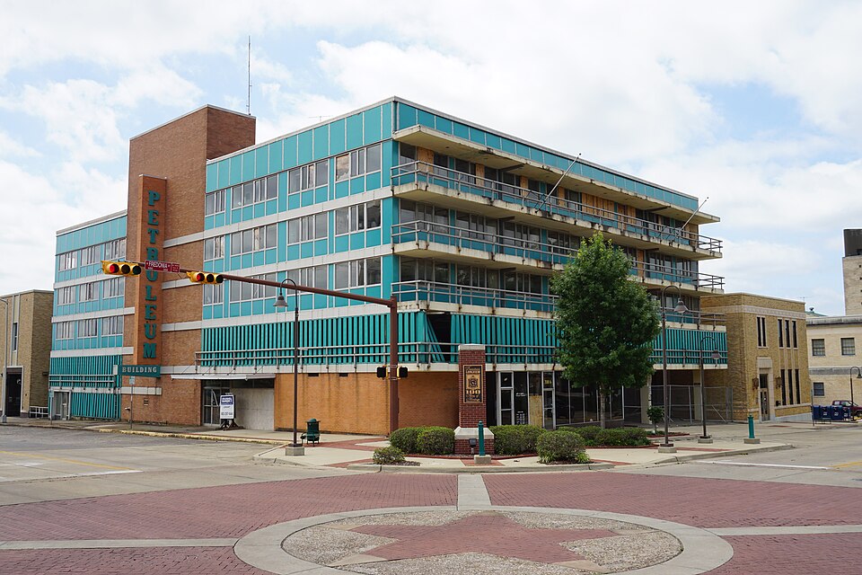
Listed on the National Register of Historic Places in 2019.
One of 9 National Register listings published here for Gregg County · listed in 2019 · category: Building.
Sources: the National Register database, National Park Service
Regional context, not property-specific evidence. The federal wildfire occurrence database lists 360 fires within 5 miles of Petroleum Building between 1992 and 2020, burning about 840 acres in total. 9 started naturally. 11 were recorded as arson. Distance is straight-line from the map coordinates, so a fire counted here may appear on a neighbouring settlement's page as well.
| Reported cause | Fires |
|---|---|
| Debris and open burning | 139 |
| Missing data/not specified/undetermined | 130 |
| Power generation/transmission/distribution | 17 |
| Recreation and ceremony | 16 |
| Equipment and vehicle use | 13 |
| Misuse of fire by a minor | 13 |
| Arson/incendiarism | 11 |
| Natural | 9 |
| Railroad operations and maintenance | 6 |
| Smoking | 5 |
| Fireworks | 1 |
The most recent of them, most recent first, with the day each was reported and the service that recorded it.
| Date | Cause | Size | Reported by | Name on the report |
|---|---|---|---|---|
| 9 September 2019 | Missing data/not specified/undetermined | 1.0 acres | Texas A & M Forest Service | HARRISON 22:15 |
| 9 September 2017 | Missing data/not specified/undetermined | under an acre | Texas A & M Forest Service | 17-0012699 |
| 7 September 2005 | Missing data/not specified/undetermined | 2.0 acres | Texas A & M Forest Service | HENDERSON - 226 |
| 7 September 2003 | Missing data/not specified/undetermined | 5.0 acres | Texas A & M Forest Service | LINDEN - 228 |
| 6 September 2016 | Equipment and vehicle use | under an acre | Texas A & M Forest Service | 16-24851 |
| 6 September 2014 | Missing data/not specified/undetermined | 5.0 acres | Texas A & M Forest Service | 6182 |
| 6 September 2014 | Power generation/transmission/distribution | under an acre | Texas A & M Forest Service | 14-0011382 |
| 6 September 2006 | Debris and open burning | 1.0 acres | Texas A & M Forest Service | LINDEN - 636 |
Regional context, not property-specific evidence. The federal mineral resources record lists 3 workings within 5 miles of Petroleum Building: 3 producers. All of them still produce. What was taken out: Sand and Gravel, Construction. Distance is straight-line from the map coordinates, so a quarry counted here may appear on a neighbouring settlement's page as well.
| Where | Site | Commodity | Status | Recorded |
|---|---|---|---|---|
| A & T Sand Pit | Sand and Gravel, Construction | Producer | ||
| Ingram Pit | Sand and Gravel, Construction | Producer | ||
| Norton Pit | Sand and Gravel, Construction | Producer |
Regional context, not property-specific evidence. The National Weather Service names Longview, the town this property stands in, in 118 storm reports between 1993 and 2026: 49 hail, 42 thunderstorm wind, 22 flash flood, 4 lightning. The reports record 1 death and 1 injury. Each account below is quoted exactly as the forecast office filed it, from the NOAA Storm Events Database, and each date opens the federal record of that event.
| When | Event | Place named | Harm | What the report says |
|---|---|---|---|---|
| September 2007 | Lightning | Longview | 1 killed | A 53 year old man was struck and killed by lightning on Cox Lane. Victim was located approximately 25 feet from a large tree that was struck by lightning. |
| September 2007 | Thunderstorm Wind | Longview | 1 hurt, $100,000 | Numerous trees and power lines were blown down. A few trees fell on top of homes in town. One injury was reported when a tree fell on a home trapping the person inside. |
| January 1998 | Hail | Longview | $1,000,000 | Grapefruit to softball size hail went through the roofs of houses and mobile homes. Two to three inch hail drifts remained along Hwy 300 between Longview and Gilmer 17 hours after it fell. |
| July 1996 | Flash Flood | Longview | $500,000 | no account filed |
| January 1998 | Hail | Longview | $125,000 | Numerous homes suffered severe roof damage resulting in water damage to the interior of homes. |
| June 2004 | Thunderstorm Wind | Longview | $50,000 | Trees down on a home in town. |
| May 1994 | Thunderstorm Wind | Longview | $50,000 | Thunderstorm winds blew a tree down onto a house in northwest Longview. |
| May 1994 | Thunderstorm Wind | Longview | $50,000 | Trees, signs, and traffic lights were blown down by thunderstorm winds. Some windows were blown out. |
| May 1994 | Thunderstorm Wind | Longview | $50,000 | Trees were blown down onto Highway 300 and roofs were damaged. |
| September 1993 | Thunderstorm Wind | Longview | $50,000 | Thunderstorm winds blew down three utility poles and some large tree limbs. |
| July 2007 | Flash Flood | Longview | $25,000 | Numerous streets and the intersection of Loop 281 and Hwy. 80 under water. A tree fell on top of a home in town resulting in moderate damage to the home. The prolonged heavy rain and the super saturation of the soil allowed the tree to fall as the weight of the tree was too heavy for the root system to support it. |
| July 2005 | Thunderstorm Wind | Longview | $25,000 | The roof to a manufacturing plant was damaged. |
| September 2013 | Flash Flood | Longview | $15,000 | Excessive heavy rainfall resulted in two cars being stranded at the intersection of High Street and Common Street. The intersection of Nelson and Green Streets was also closed due to high water. |
| August 2005 | Lightning | Longview | $15,000 | Lightning struck a large oak tree on Pegues Street near 4th Street. The tree split and crashed down onto a home. |
| August 2000 | Thunderstorm Wind | Longview | $12,000 | Loaded utility trailer picked up and blown 100 feet. Large tree limbs up to 4 inches in diameter broken off. Several large trees toppled. |
| April 2012 | Thunderstorm Wind | Longview | $10,000 | A tree was downed on a house in the 400 Block of South Jean Street. |
| August 2005 | Thunderstorm Wind | Longview | $10,000 | Roofs were damaged by winds at the Bobo Lumber Yard. Some trees were also downed on powerlines along Hwy 31. |
| January 1996 | Thunderstorm Wind | Longview | $10,000 | no account filed |
| June 2011 | Lightning | Longview | $5,000 | Lightning struck the Greggton United Methodist Church and tore bricks off the church. |
| November 2005 | Thunderstorm Wind | Longview | $5,000 | A home suffered roof damage from strong winds on North Gilmer Rd. |
| March 1998 | Thunderstorm Wind | Longview | $5,000 | Several trees were toppled in town leading to numerous power outages. |
| May 1994 | Thunderstorm Wind | Longview | $5,000 | Trees were blown down by thunderstorm winds. |
| November 1994 | Thunderstorm Wind | Longview | $5,000 | Trees blown down by high winds, blocked some streets. There was also roof damage from falling trees. |
| August 1995 | Thunderstorm Wind | Longview | $3,000 | A carport was lifted off its concrete foundation and several windows were blown out of a house. |
| August 2005 | Flash Flood | Longview | $1,000 | Water was over the roadway near the Jones Road Bridge. |
| April 2026 | Hail | Longview | - | Quarter size hail reported in Longview, via Mping. |
| March 2025 | Hail | Longview | - | Penny size reported in Longview via Mping. |
| April 2025 | Hail | Longview | - | Ping pong ball size hail fell at the Longview Police Department. |
| April 2025 | Hail | Longview | - | Ping pong ball size hail fell near Christus Good Shepherd Medical Center in Longview. |
| April 2025 | Hail | Longview | - | Quarter size hail fell along West Avalon Avenue in Longview. |
| August 2025 | Flash Flood | Longview | - | Flooding reported with high water covering the roadway on Green Street. |
| August 2025 | Flash Flood | Longview | - | Flash flooding reported with a high water rescue near Green Street and Nelson Street. |
| February 2024 | Hail | Longview | - | Baseball size hail reported via social media. |
| April 2023 | Hail | Longview | - | Ping pong ball size hail fell just southeast of Longview. |
| April 2023 | Hail | Longview | - | Golfball size hail fell throughout much of Longview. |
| July 2021 | Flash Flood | Longview | - | Flooding reported at the intersection of Green and Cotton Street. |
| July 2021 | Flash Flood | Longview | - | Flooding reported at the intersection of Cotton and High Street. Several water rescues were required for stranded motorists in the flood waters. |
| April 2020 | Thunderstorm Wind | Longview | - | Trees were downed on Sabine Street in South Longview. |
| March 2018 | Hail | Longview | - | Quarter size hail in the southeast sections of Longview. |
| October 2014 | Hail | Longview | - | Ping pong ball sized hail was reported just southeast of town. |
| August 2012 | Thunderstorm Wind | Longview | - | A tree was downed on Georgia Richie Road just west of town. |
| March 2008 | Flash Flood | Longview | - | Three foot of water on road near Highway 80 and Green Street. |
| March 2008 | Flash Flood | Longview | - | High water rescue under a bridge on High Street and Cotton Street. |
| July 2007 | Flash Flood | Longview | - | Multiple roads flooded and closed throughout the county. |
| September 2007 | Hail | Longview | - | Penny sized hail fell in Longview. |
| June 2007 | Thunderstorm Wind | Longview | - | Trees and power lines were downed across the northern portion of the county. |
| June 2007 | Flash Flood | Longview | - | Excessive heavy rainfall resulted in flash flooding which washed out a bridge in the northern portion of the county. Several secondary roads were also under water as well. |
| July 2005 | Hail | Longview | - | Hail fell on the northeast side of town on Loop 281. |
| July 2005 | Thunderstorm Wind | Longview | - | Power lines were downed along Hwy 300. |
| July 2005 | Thunderstorm Wind | Longview | - | Trees were downed. |
| August 2005 | Thunderstorm Wind | Longview | - | Several trees were downed. |
| June 2004 | Thunderstorm Wind | Longview | - | Trees and power lines downed on the north side of town. |
| August 2003 | Flash Flood | Longview | - | Numerous streets flooded and impassible in the northwest portion of the city. |
| April 2003 | Lightning | Longview | - | Cloud to ground lightning struck an oil storage tank in northeast Longview just south of FM 2751 and Highway 250 Intersection. The oil tank blew apart and caught fire. The explosion was heard as far as 5 miles away. |
| June 2003 | Flash Flood | Longview | - | Several streets were closed due to high water. |
| December 2002 | Flash Flood | Longview | - | Eastman Road one mile south of Highway 80 and Houston Street at 1104 was underwater from excessive heavy rains. |
| April 2002 | Flash Flood | Longview | - | Numerous city streets underwater. |
| May 2000 | Thunderstorm Wind | Longview | - | Several large trees down. |
| May 2000 | Thunderstorm Wind | Longview | - | Power lines down across the city. |
| August 1999 | Hail | Longview | - | Along Hwy 80. |
No historic map-sheet match is published for this property yet. That does not mean no map exists. This record needs a coordinate-quality review before it can be joined to a sheet boundary. Browse the county's mapped places while that work is pending.
Other National Register properties close enough to walk or drive between, ordered by distance from this one. Both positions come from the same geocoding pass that matched these properties to their map sheets.
| Photograph | Property | Distance | Listed |
|---|---|---|---|
 | Whaley House | under 500 feet | 1980 |
| Longview National Bank | under 500 feet | 2023 | |
| McWilliams Building | 0.1 miles | 2019 | |
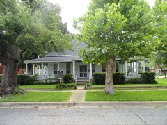 | Frank Taylor and Kate Womack Rembert House | 0.3 miles | 2011 |
 | Northcutt House | 0.4 miles | 1978 |
| Nuggett Hill Historic District | 0.8 miles | 1998 |
| National Archives record | The nomination case file for reference 100003494 in Record Group 79. |
| Gregg County | All 9 listed properties in this county. |