 Block
BlockFrom the record
One of 7 National Register listings published here for Caldwell County · listed in 2021 · category: District.
Sources: the National Register database, National Park Service
Listed on the National Register of Historic Places in 2021.
One of 7 National Register listings published here for Caldwell County · listed in 2021 · category: District.
Sources: the National Register database, National Park Service
Regional context, not property-specific evidence. The federal wildfire occurrence database lists 81 fires within 5 miles of Martindale Central Historic District between 2000 and 2018, burning about 1,950 acres in total. 1 started naturally. 3 were recorded as arson. Distance is straight-line from the map coordinates, so a fire counted here may appear on a neighbouring settlement's page as well.
| Reported cause | Fires |
|---|---|
| Debris and open burning | 43 |
| Missing data/not specified/undetermined | 16 |
| Equipment and vehicle use | 14 |
| Arson/incendiarism | 3 |
| Smoking | 2 |
| Railroad operations and maintenance | 1 |
| Natural | 1 |
| Fireworks | 1 |
The most recent of them, most recent first, with the day each was reported and the service that recorded it.
| Date | Cause | Size | Reported by | Name on the report |
|---|---|---|---|---|
| 6 September 2015 | Missing data/not specified/undetermined | under an acre | Texas A & M Forest Service | HAY HAY |
| 4 September 2011 | Equipment and vehicle use | 3.0 acres | Texas A & M Forest Service | WILLIAM PETUS/21 |
| 23 September 2013 | Equipment and vehicle use | under an acre | Texas A & M Forest Service | 142 |
| 23 September 2011 | Debris and open burning | 1.0 acres | Texas A & M Forest Service | THIRD ST |
| 6 August 2012 | Equipment and vehicle use | under an acre | Texas A & M Forest Service | GRASS FIRE |
| 22 August 2018 | Debris and open burning | 6.0 acres | Texas A & M Forest Service | COW TRAIL FIRE |
| 13 August 2008 | Debris and open burning | 15 acres | Texas A & M Forest Service | not named |
| 5 July 2011 | Debris and open burning | 1.0 acres | Texas A & M Forest Service | PECAN PARK |
Regional context, not property-specific evidence. The federal mineral resources record lists 3 workings within 5 miles of Martindale Central Historic District: 2 producers, 1 unknown. 2 still produce. What was taken out: Sand and Gravel, Construction. Distance is straight-line from the map coordinates, so a quarry counted here may appear on a neighbouring settlement's page as well.
| Where | Site | Commodity | Status | Recorded |
|---|---|---|---|---|
| Cummings | Sand and Gravel, Construction | Unknown | ||
| Mercer Pit & Plant | Sand and Gravel, Construction | Producer | ||
| Thompson Pit & Plant | Sand and Gravel, Construction | Producer |
Regional context, not property-specific evidence. The National Weather Service names Martindale, the town this property stands in, in 22 storm reports between 1996 and 2025: 12 thunderstorm wind, 8 hail, 1 tornado, 1 flash flood. The reports record 2 deaths. Each account below is quoted exactly as the forecast office filed it, from the NOAA Storm Events Database, and each date opens the federal record of that event.
| When | Event | Place named | Harm | What the report says |
|---|---|---|---|---|
| December 2018 | Flash Flood | Martindale | 2 killed | Thunderstorms produced heavy rain that led to flash flooding sending Morrison Creek over SE River Rd. outside Martindale. Two people were killed when their vehicle was swept into the flood waters. |
| June 2003 | Thunderstorm Wind | Martindale | $13,000,000 | As the downburst crossed the Hays County line into Caldwell County, it struck the San Marcos Airport located in extreme eastern Caldwell County. The severe winds caused nearly $7 million in damages to hangars and to between 25 and 30 general aviation aircraft. As it exited the airport, the downburst moved across the Gary Job Corps Center, damaging buildings and knocking over trees. An additional $5 million damage was estimated at the campus. The downburst moved past the campus, across open country and through the town of Martindale. Amateur Radio operators reported trees blown down and damage to numerous roofs, vehicles and fences from west of Martindale and throughout the town. Winds in the event at the airport were estimated at between 80 and 90 knots. |
| April 2007 | Thunderstorm Wind | Martindale | $150,000 | The bow-shaped line along the Hays-Guadalupe-Wilson Counties accelerated as it crossed into Caldwell and Gonzales Counties after 1 am CST. The storms were now producing widespread wind gusts of 60 to 70 knots, with spotty higher gusts approaching 90 knots. Again, most of the damage was in the form of trees blown down, with some damages to roofs of homes. The worst damage was noted in central Lockhart where a old house was blown down. Wind gust estimates at this location were near 95 knots. |
| May 2024 | Thunderstorm Wind | Martindale | $100,000 | A thunderstorm produced wind gusts estimated at 70 mph that damaged trees, power poles, and power lines along the Guadalupe-Caldwell county line near Martindale. |
| November 2000 | Thunderstorm Wind | Martindale | $30,000 | Severe thunderstorms winds blew down power lines in the Martindale area. |
| June 2022 | Thunderstorm Wind | Martindale | $5,000 | A thunderstorm produced wind gusts estimated at 60 mph that knocked down a fence and damaged a roof at Scull Rd. and NW River Rd. in Martindale. |
| May 2017 | Thunderstorm Wind | Martindale | $5,000 | A thunderstorm produced wind gusts estimated at 70 mph that knocked down trees in and around Martindale. |
| October 2000 | Thunderstorm Wind | Martindale | $5,000 | A downburst from a severe thunderstorm damaged trees, homes between Martindale and Kyle |
| October 2000 | Tornado (F0) | Martindale | $3,000 | A small and short-lived tornado touched down briefly near a home. It lifted a metal barn vertically, twisting and tossing it. |
| May 2025 | Hail | Martindale | - | A thunderstorm produced chicken egg size hail in Martindale. |
| April 2023 | Hail | Martindale | - | A thunderstorm produced hail up to quarter size in Martindale. Hail covered the ground. Most of the hail was nickel size and smaller with a few stones up to an inch. |
| June 2019 | Thunderstorm Wind | Martindale | - | A thunderstorm produced wind gusts estimated at 60 mph in Martindale. |
| February 2017 | Thunderstorm Wind | Martindale | - | A thunderstorm produced wind gusts estimated at 70 mph that damaged a barn roof, front porch awning, and knocked down a 100 year old tree. |
| April 2015 | Thunderstorm Wind | Martindale | - | A thunderstorm produced a wind gust estimated at 59 mph by a former NWS employee. |
| April 2006 | Thunderstorm Wind | Martindale | - | Severe thunderstorm winds blew down trees near Martindale. |
| July 2005 | Thunderstorm Wind | Martindale | - | Thunderstorms forming along the northern Texas Hill Country in the late afternoon spread into Caldwell County by late evening. The storms blew down power lines north of Martindale. |
| April 2006 | Hail | Martindale | - | no account filed |
| May 2004 | Hail | Martindale | - | no account filed |
| May 2000 | Hail | Martindale | - | no account filed |
| February 1998 | Hail | Martindale | - | no account filed |
| June 1998 | Hail | Martindale | - | no account filed |
| May 1996 | Hail | Martindale | - | no account filed |
No historic map-sheet match is published for this property yet. That does not mean no map exists. This record needs a coordinate-quality review before it can be joined to a sheet boundary. Browse the county's mapped places while that work is pending.
Other National Register properties close enough to walk or drive between, ordered by distance from this one. Both positions come from the same geocoding pass that matched these properties to their map sheets.
| Photograph | Property | Distance | Listed |
|---|---|---|---|
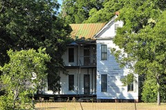 | M. A. Withers House | 7.3 miles | 1976 |
| National Archives record | The nomination case file for reference 100006859 in Record Group 79. |
| Caldwell County | All 7 listed properties in this county. |