 Block
BlockFrom the record
One of 34 National Register listings published here for Cameron County · listed in 2021 · category: Building.
Sources: the National Register database, National Park Service
Listed on the National Register of Historic Places in 2021.
One of 34 National Register listings published here for Cameron County · listed in 2021 · category: Building.
Sources: the National Register database, National Park Service
Regional context, not property-specific evidence. The federal wildfire occurrence database lists 98 fires within 5 miles of Lillian and George K. Aziz Essey House between 1994 and 2020, burning about 1,113 acres in total. None started naturally. 23 were recorded as arson. Distance is straight-line from the map coordinates, so a fire counted here may appear on a neighbouring settlement's page as well.
| Reported cause | Fires |
|---|---|
| Missing data/not specified/undetermined | 37 |
| Debris and open burning | 29 |
| Arson/incendiarism | 23 |
| Railroad operations and maintenance | 3 |
| Power generation/transmission/distribution | 2 |
| Recreation and ceremony | 2 |
| Smoking | 1 |
| Fireworks | 1 |
The most recent of them, most recent first, with the day each was reported and the service that recorded it.
| Date | Cause | Size | Reported by | Name on the report |
|---|---|---|---|---|
| 13 September 2017 | Missing data/not specified/undetermined | 1.0 acres | Texas A & M Forest Service | GRASS FIRE |
| 4 August 1996 | Missing data/not specified/undetermined | 10 acres | Lower Rio Grande Valley National Wildlife Refuge | PHILLIPS |
| 27 August 1998 | Debris and open burning | 10 acres | Lower Rio Grande Valley National Wildlife Refuge | JERONIMO 2 |
| 21 August 2017 | Missing data/not specified/undetermined | under an acre | Santa Ana National Wildlife Refuge | FISH HATCHERY |
| 21 August 2004 | Arson/incendiarism | 2.0 acres | Lower Rio Grande Valley National Wildlife Refuge | WOOD |
| 17 August 2017 | Debris and open burning | 1.0 acres | Texas A & M Forest Service | GRASS FIRE |
| 7 July 2005 | Debris and open burning | 21 acres | Lower Rio Grande Valley National Wildlife Refuge | PHILLIPS BANCO |
| 6 July 2005 | Arson/incendiarism | under an acre | Lower Rio Grande Valley National Wildlife Refuge | VILLA 2 |
Regional context, not property-specific evidence. The federal mineral resources record lists 6 workings within 5 miles of Lillian and George K. Aziz Essey House: 5 producers, 1 past producer. 5 still produce. What was taken out: Fluorine-Fluorite, Chromium, Manganese, Strontium, Fluorine-Fluorite, Barium-Barite. Distance is straight-line from the map coordinates, so a quarry counted here may appear on a neighbouring settlement's page as well.
| Where | Site | Commodity | Status | Recorded |
|---|---|---|---|---|
| Brownsville Minerals Plant | Barium-Barite | Producer | ||
| Brownsville Plant | Manganese | Producer | ||
| C E Minerals Chrome Plant | Chromium, Manganese, Strontium, Fluorine-Fluorite, Barium-Barite | Past Producer | ||
| Brownsville Mill | Fluorine-Fluorite | Producer | ||
| Brownsville Mill | Fluorine-Fluorite | Producer | ||
| Oglebay Norton Fluorspar Plant | Fluorine-Fluorite | Producer |
Regional context, not property-specific evidence. The National Weather Service names Brownsville, the town this property stands in, in 55 storm reports between 1993 and 2024: 23 flash flood, 12 thunderstorm wind, 11 hail, 5 flood. The reports record 5 injuries. Each account below is quoted exactly as the forecast office filed it, from the NOAA Storm Events Database, and each date opens the federal record of that event.
| When | Event | Place named | Harm | What the report says |
|---|---|---|---|---|
| April 2003 | Hail | Brownsville | 5 hurt, $50,000,000 | no account filed |
| June 2018 | Flash Flood | Brownsville | $20,000,000 | One day after 3 to more than 5 inches fell between Brownsville and Los Fresnos during the afternoon and early evening hours, a repeat event occurred, fed by deep tropical moisture and multiple boundaries left behind from devastating morning flooding across western Cameron and eastern Hidalgo County. A persistent line of torrential rainfall dominated through the early evening commute, with another 3 to 6 inches having fallen for a two-day total of 6 to 11+ inches. The second day rainfall produced more widespread flooding across locations in and east of Brownsville and Los Fresnos, with farm and subdivisions under 2 to 3+ feet of water when all was said and done. ||The additional flooding on saturated soils (pump priming from June 19) likely produced more damage this second go-round, including more erosion to drainage canals/ditches and mainly rural roads. Doubling of the damage left a total of around $20 million. |
| November 1998 | Thunderstorm Wind | Brownsville | $76,000 | no account filed |
| April 2006 | Thunderstorm Wind | Brownsville | $50,000 | Estimated gusts were reported by a National Weather Service employee. Widespread minor wind damage was reported in Brownsville, Harlingen and Los Fresnos due to strong outflow winds produced by thunderstorms in the area. |
| March 1993 | Thunderstorm Wind | Brownsville | $50,000 | Thunderstorm winds knocked down a few utility poles and uprooted a few trees. Quarter-size hail was reported in the Lakeway subdivision north of Brownsville. |
| March 2004 | Flash Flood | Brownsville | $25,000 | Heavy rains over Cameron county produced flash flooding. Flash flooding of roads and small streams was reported over western sections of the city of Brownsville and also in the Paseo de la Resaca area. |
| September 2003 | Flash Flood | Brownsville | $25,000 | The general public reported water entering the school buildings at Hanna High School. |
| October 2023 | Flash Flood | Brownsville | $15,000 | Torrential rains of nearly 4 inches in an hour (2 to 3 PM CST; 3 to 4 PM CDT) fell across west Brownsville as a strong cluster of thunderstorms eased through the city. More than 3 feet of water piled up near the B&M Bridge along Mexico Blvd. near the bridge (and in the C and D street vicinity. Several cars were submerged up to the hoods. A CoCoRaHS observer in the Los Ebanos community, 2 miles northeast of the worst flooding, recorded 3.7 inches of rain. |
| October 2021 | Flash Flood | Brownsville | $10,000 | Brownsville Police Dept reported road closures due to flooding on East Washington St in downtown Brownsville. |
| November 2013 | Flash Flood | Brownsville | $10,000 | Between 4.23 to 4.96 inches of rainfall fell in less than 90 minutes across western Brownsville, leading to flash flooding across that portion of the city. The Brownsville Emergency Operations Center reported several businesses with some water in them, numerous thoroughfares with several inches to nearly 2 feet of water on them acorss the area limiting travel. During the peak of the rains, 42 streets had flooding that reduced travel to one lane or less. Some resacas were also reported to have reached bankful or flooded low lying grassy areas. |
| May 2010 | Thunderstorm Wind | Brownsville | $10,000 | A 20 year old cottonwood tree, renowned and visited often for having a purported image of the Virgin Mary on its bark, was blown down by strong thunderstorm winds estimated to have occurred between 905 and 910 AM CST at the intersection of East Levee and 10th Streets in downtown Brownsville. Numerous, varying sized limbs were blown down in Greater Brownsville, with peak gusts recorded at the Brownsville/South Padre Island Airport reaching 54 mph at 928 AM CST, 5 miles east of downtown. |
| December 2006 | Thunderstorm Wind | Brownsville | $10,000 | Off-duty NWS employee reported that a light pole was blown down on top of a car by thunderstorm winds near the intersection of FM Road 802 and Paredes Line Road. |
| June 2023 | Flood | Brownsville | $5,000 | Members of the public shared videos of Mexico Blvd, just north of the intersection with Sam Perl Blvd, under the railroad tracks with an estimated 2 feet of water. One car was stranded and flooded in the video. The car and flooding was still there an hour later showing the car still stranded. |
| April 2016 | Thunderstorm Wind | Brownsville | $5,000 | Brownsville Police Department reported three electrical poles down along U.S. Highway 281. |
| May 2021 | Thunderstorm Wind | Brownsville | $2,000 | Off-duty NWS Employee reported several tree limbs up to 5 inches in diameter snapped off of trees nearby. Time and duration was estimated via radar. |
| September 2024 | Flash Flood | Brownsville | - | There were several reports of flash flooding in the city of Brownsville, mainly bracketed by Price Road and Expressway IH-69E on the west, Price Road and State Highway 48 on the east, extending to the Southmost neighborhood on the south side of the city. Reports included: Multiple intersections along Boca Chica Blvd impassable due to flooded roadways between McDavitt Blvd and Kings Hwy and Boca Chica was nearly impassable, as well as the intersection known as Four Corners at State Highway 4; flooding extending along State Highway 4 to Southmost Blvd., and flooding along and near the frontage road at Price Road and IH-69E, extending to Barnard Road, and to nearby apartment complexes and shopping centers in this area.||While all locations inside the ascribed polygon may not have reached flash flood levels - 3 feet or higher of ponded water - the reports of impassible roads and photographic evidence suggesting pockets of this level of water depth made the case for a flash flood event in these areas.||Damage to any property was unknown as of this writing. |
| April 2023 | Thunderstorm Wind | Brownsville | - | Member of the public shared two large trees either uprooted or snapped near the base of the tree near the intersection of Del Mar and Russell Avenue. Timing based on radar. |
| July 2021 | Flash Flood | Brownsville | - | Brownsville Police reported that about 30 streets in the city were experiencing flooding. Floodwaters were deep enough to prevent cars from traveling through. |
| July 2021 | Flash Flood | Brownsville | - | Pictures received via social media of flooding estimated at 2 to 3 feet of water depth at Old Alice Road and Price Road in Brownsville, with water nearing gas pumps and buildings. This location is a flood-prone area which has seen several similar events since 2010. |
| May 2020 | Flood | Brownsville | - | Picture showing minor flooding at the intersection of Villa Maria Blvd and W. Washington St. |
| October 2014 | Flash Flood | Brownsville | - | Emergency management, local law enforcement, and members of the public reported flash flooding across portions of Brownsville, especially the western and downtown areas. There were several reports of 3 feet or more of water into properties. |
| May 2014 | Thunderstorm Wind | Brownsville | - | NWS employee reported several one to two foot diameter trees snapped with estimated 60 mph wind gusts. |
| May 2014 | Heavy Rain | Brownsville | - | Almost an hour of heavy rain fell across Brownsville during the late afternoon hours of May 28th. CoCoRaHS observers reported between 2 and a little over 2.5 inches of rain across western Brownsville. The downpours resulted in streets in downtown Brownsville being covered in as much 18 inches of water, especially near Palm Boulevard, where trash cans were reported floating along the roadway. |
| December 2009 | Heavy Rain | Brownsville | - | Rain, heavy at times during the daylight hours of the 16th, accumulated between 1 1/2 and 2 1/2 inches between 6 AM and 6 PM in a pocket of central Cameron County along and near Highway 77, between Brownsville and Harlingen. The rainfall caused areas of nuisance (minor) flooding of poor drainage roadways in the area during the daylight hours of the 16th, slowing traffic. Event totals in Cameron County included 4.52 inches in Rancho Viejo, 3.82 inches near Brownsville, and 3.79 inches just west of Harlingen. |
| September 2009 | Heavy Rain | Brownsville | - | Locally heavy rains fell across portions of Deep South Texas during the day September 10th. An upper level disturbance which moved through the County Warning Area during the day triggering showers and thunderstorms which produced locally heavy rains through the day. One observer reported 3.92 inches of rainfall during the afternoon in Cameron County two miles west of Brownsville which caused a lot of street flooding in the area. Several other observers in Cameron County reported rainfall ranging from 2.22 inches northeast of Los Fresnos to 2.78 inches three miles north of Brownsville. |
| September 2009 | Hail | Brownsville | - | The public reported hail up to three quarters of an inch in size fell during a thunderstorm. The hail was observed near the intersection of Elizabeth Street and Central Boulevard. |
| March 2007 | Flash Flood | Brownsville | - | Morrison Road exit at U.S. Highway 77 under three feet of standing water. |
| March 2007 | Flash Flood | Brownsville | - | Forty to fifty cars stalled along Boca Chica Boulevard with water over the wheel wells in some places. |
| March 2007 | Heavy Rain | Brownsville | - | Two inches of rain observed in an hour. |
| March 2007 | Flash Flood | Brownsville | - | Standing water three to four feet deep was reported on Palm Boulevard. |
| March 2007 | Flash Flood | Brownsville | - | Numerous streets and roads under standing water 2 feet deep. |
| July 2006 | Flash Flood | Brownsville | - | Extensive flash flooding of streets was reported in Brownsville by law enforcement and emergency management officials. |
| July 2005 | Flash Flood | Brownsville | - | Heavy rains from the outer rainbands of Hurricane Emily produced flash flooding that resulted in the closing of Highway 4 seven miles north of F.M. Road 511. |
| October 2003 | Flash Flood | Brownsville | - | Heavy rains in Cameron county resulted in the flash flooding of the Resaca Calmada over its banks in the Paseo de la Resaca development. |
| September 2003 | Flash Flood | Brownsville | - | An off-duty NWS employee reported flash flooding of city streets near downtown Brownsville due to heavy rains. |
| September 2003 | Flash Flood | Brownsville | - | Flash flooding of access roads was reported in eastern Brownsville. No flooding of businesses or homes was reported. |
| September 2003 | Flash Flood | Brownsville | - | The resacas in the Paseo de la Resaca development overflowed their banks due to heavy rains, threatening several homes. |
| September 2003 | Flash Flood | Brownsville | - | Flash flooding of Paredes Line road in Brownsville stranded numerous automobiles north of the Paseo de la Resaca development near Cameron Park. |
| November 2002 | Flood | Brownsville | - | Heavy morning rainfall caused some small streams or resacas in Brownsville to overflow their banks. |
| September 2002 | Flood | Brownsville | - | Day-long moderate to heavy rains produced extensive urban flooding as well as flooding of low spots in Brownsville. |
| October 2002 | Flash Flood | Brownsville | - | Intense thunderstorms produced very heavy rains and flash flooding throughout eastern portions of Cameron county. Water entered several homes and businesses in both Brownsville and Laguna Vista. |
| October 2002 | Flood | Brownsville | - | Prolonged rains produced street flooding in Brownsville. |
| October 2002 | Flash Flood | Brownsville | - | Strong thunderstorms produced flash flooding that entered homes in Brownsville. |
| January 1993 | Hail | Brownsville | - | ,Pea to quarter-size hail was reported in Brownsville near the Airport. |
| March 1993 | Hail | Brownsville | - | Thunderstorm winds knocked down a few utility poles and uprooted a few trees. Quarter-size hail was reported in the Lakeway subdivision north of Brownsville. |
| May 2005 | Thunderstorm Wind | Brownsville | - | no account filed |
| April 2003 | Hail | Brownsville | - | no account filed |
| April 2003 | Hail | Brownsville | - | no account filed |
| April 2003 | Hail | Brownsville | - | no account filed |
| April 2003 | Hail | Brownsville | - | no account filed |
| April 2003 | Hail | Brownsville | - | no account filed |
| August 2003 | Thunderstorm Wind | Brownsville | - | no account filed |
| April 1999 | Hail | Brownsville | - | no account filed |
| April 1999 | Hail | Brownsville | - | no account filed |
| August 1996 | Thunderstorm Wind | Brownsville | - | no account filed |
No historic map-sheet match is published for this property yet. That does not mean no map exists. This record needs a coordinate-quality review before it can be joined to a sheet boundary. Browse the county's mapped places while that work is pending.
Other National Register properties close enough to walk or drive between, ordered by distance from this one. Both positions come from the same geocoding pass that matched these properties to their map sheets.
| Photograph | Property | Distance | Listed |
|---|---|---|---|
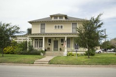 | Hicks-Gregg House | under 500 feet | 2009 |
| Rio Grande Valley Gas Company Building | 0.5 miles | 2022 | |
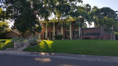 | M.E. and Estela Cueto Garcia House | 0.8 miles | 2017 |
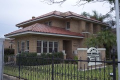 | Manautou House | 0.8 miles | 1983 |
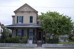 | Browne-Wagner House | 0.9 miles | 1977 |
| Morris-Browne House | 1.0 miles | 2006 |
| National Archives record | The nomination case file for reference 100006889 in Record Group 79. |
| Cameron County | All 34 listed properties in this county. |